Tuesday, December 29, 2020

The Bad, The Good, and The Bad - and Maybe Ugly (12/29/20)

If you didn't get a chance to read the previous post I did on the 24th, click here.  

The advertised precipitation event I discussed back on the 17th, was just a tad slower in evolving.  Some of the precipitation began the night of the 27th with a band of snow that moved across west central Kansas into northeast Colorado, northern Kansas and into Nebraska.  The second wave of precipitation began last night and into this morning (29th).  Here is a precipitation map from late on the 27th until 7 AM this morning....


The rain, freezing rain and sleet that started overnight and continued through much of the day as it shifted east was not necessarily a single storm.  Rather it was a maxima in the upper level wind field that promoted what is called a "warm conveyer belt" and produced lift across the relatively shallow cold airmass aided by a surface warm front that was moving up into southern Oklahoma.   Here is the 24 hour precipitation map for Kansas, ending at 4 PM and provided by the Kansas State Mesonet...


So, the bad.  Well, this "significant" precipitation event was farther east than what would have been preferred for the drought area of the high plains.  That has been a common theme for much of the fall and now early winter.  Comparing the map above to what occurred around in early November...this pattern of precipitation was farther east by about 50 miles (in regards to the heavier precipitation).  These sharp gradients of very little to a whole lot have repeatedly occurred this past 70-80 days.

The Good?  It was another significant precipitation generating weather system for the central U.S. that was "right on track" as far as long range predictability.  This boosts confidence going forward for other potential impacting events.

The bad or maybe ugly?  The same area that has missed the big events may miss many of storms going into spring.  The caveat is that some of the forcing areas around the northern hemisphere generating these storms have changed slightly.  My hope would be the pattern could shift west a little, with time.  

Looking at this mornings upper level chart....

                                                          500 MB - 12/29/20 at 12 Z


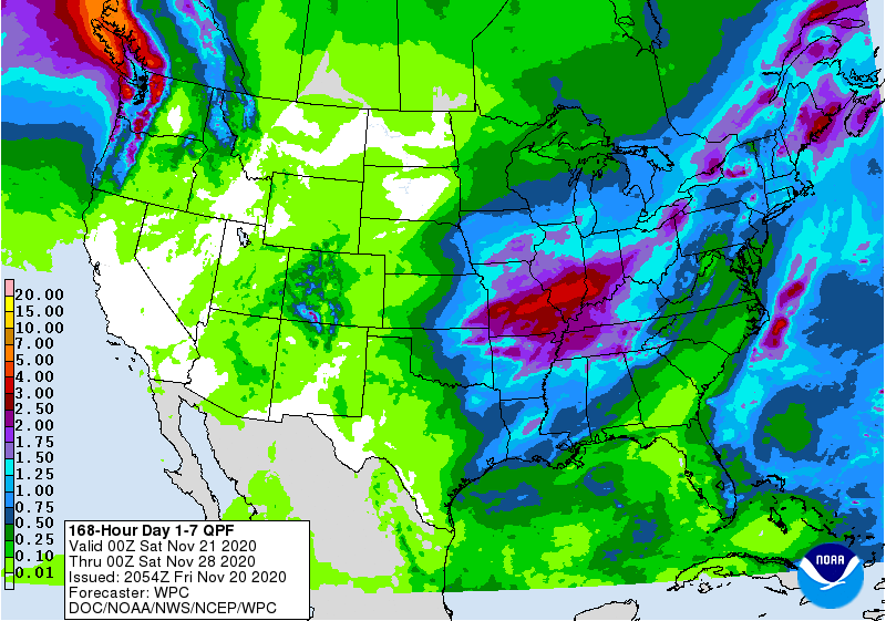
The main upper level storm was located across western Arizona.  Typically this would be a nearly perfect location to impact the high plains.  However, because of upper level ridging across the north Pacific and something referred to as Rosby Wave Propagation across the entire Pacific basin, this upper level low is predicted to take a track closely resembling the red arrow.  That is, the upper level low will intensify/amplify as it dives across northern Mexico before lifting rapidly northeast and then north across the mid-Mississippi Valley.  That will result in a tremendous amount (remarkably high) of precipitation (mainly rain)!  However, that track also keeps the precipitation out of the high plains.  IF, the storm were to take a track annotated by the green arrow, then we'd be in good gravy.  That won't happen (99% chance it won't).  Here is the outlook from the Weather Prediction Center (and keep in mind this in addition to what fell today)...


The western edge may be a bit too far west. 

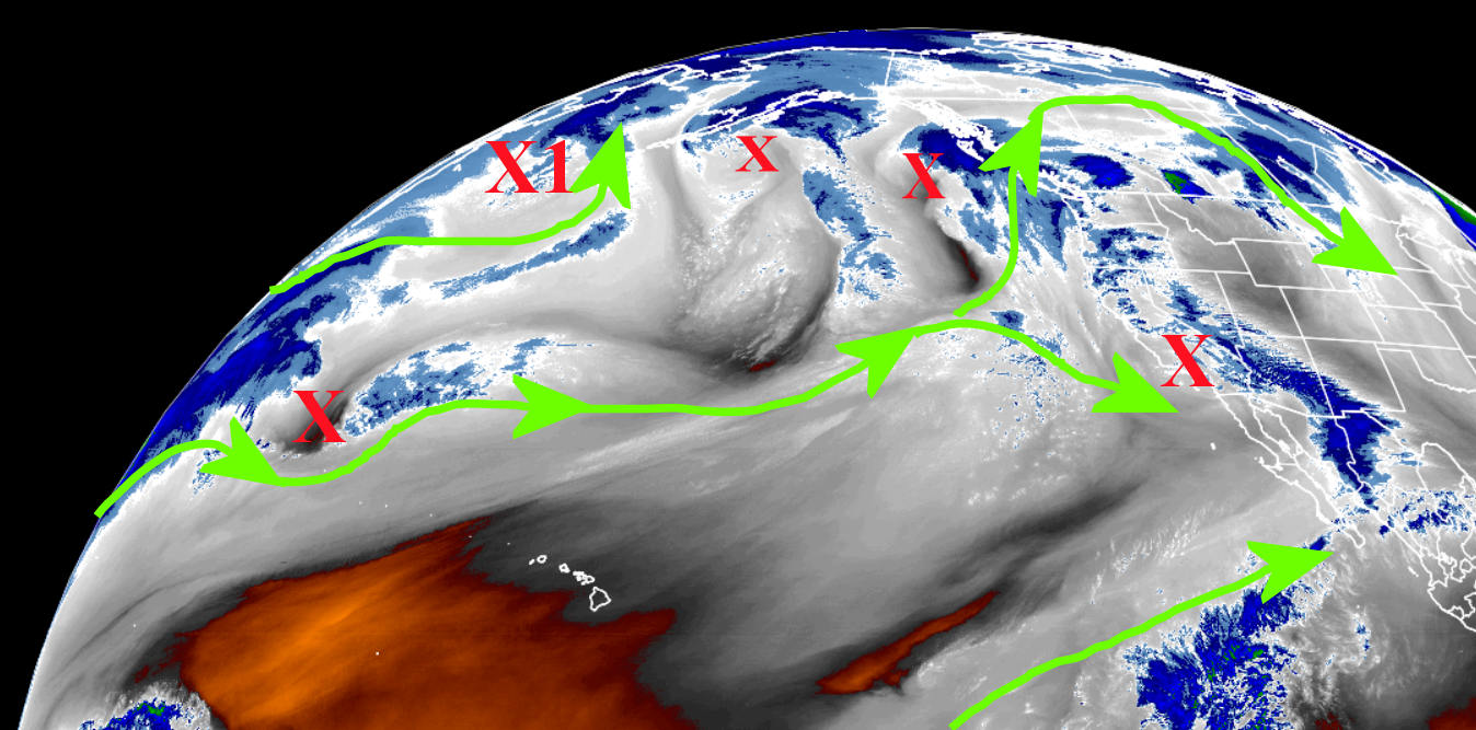
You may also notice lots of precipitation across the west coast.  Great for them!  It also is an indication of an active upper level pattern across the Pacific.   I'm seeing indications of a developing extended east Asian jet stream (very energetic winds coming off the mainland due to very high pressures across Siberia).  That could very well impact the central U.S. once again around January 9, give or take a day.  That should be the next significant chance of precipitation after this Thursday/Friday (again east of the high plains).


Thursday, December 24, 2020

Merry Christmas!

 In the previous post on the 17th, and it was a long one, I discussed a potential significant storm centered on December 27, give or take a day or two.  There was a lot of information in that post and you can read it here.  Ten days away and I put that date out there.  At the time there were NO computer forecast models with anything at all through the end of the year.  As late as 21st there was a lot of social media from various folks discussing above normal temperatures and below normal precipitation with NO storms through the end of December.   I was patiently waiting for those computer models (and the forecasters) to finally pick up on the possibility.   So, here we are on the 24th and I'm sure a lot of you have already heard the chatter about a significant storm next week.  Is it a slam dunk at this point?  No, not yet because of the complexity of what is going on with the jet stream, especially across the Pacific.

Here is a snapshot of the atmosphere late this afternoon....


The winds aloft across the Pacific are active and very complicated.  There are several source regions for energy, both tropical, mid-latitude, and higher latitude influences.  The red X's are disturbances (or storms) aloft with varying intensities.  The one that has my attention I labeled X1 near the Aleutian island chain of Alaska.   This disturbance in the wind field "should" begin to amplify as it approaches the west coast.  If not, there may be another development.  Regardless, amplification of the wind field should occur across the western U.S. starting late in the weekend and the result will be a widespread precipitation event for the central U.S., including much of the plains.

What makes a forecast with any detail impossible at this point is that it is uncertain which disturbance will become the main storm.  How amplified will it be?  What track will it take?  Exactly when does it move across the plains?  How cold will the airmass be?  Will it be cold enough to support all snow?  Freezing rain?  Sleet?  Thunderstorms?  Wow, there are MANY possibilities!  At this point, it's best to follow weather.gov as we get closer to the event.  You will see many computer solutions on social media, and THAT I can be certain about.  Some of these computer model solutions I've seen have ridiculous amounts of precipitation.  Some solutions (from the American model) keep much of the high plains dry while others are very wet.

As for that date of the 27th that I mentioned in that blog posting on the 17th...it looks like there could already be a little freezing drizzle as early as late on the 27th although the main "show" will probably be later on the 28th into the 29th.  

Here is an "early guess" from the Weather Prediction Center on precipitation amounts incorporating this potential storm.  At this point, it's just a broad brush of possible amounts.  Again, details are not possible at this point.  


If I get a bit of time, I may try and update this blog late Sunday or early Monday.


Thursday, December 17, 2020

The pattern has started to repeat - I think (updated 12/17/20)

This one will be a long one....

The previous posting was on the 25th of November (you can read that one here) and I waited to update with a purpose.  As many readers are aware, the repeating or cycling of the "new" weather pattern that develops in the fall and the periodicity of that repeating is not known until the first cycle has ended.  Looking closely at the northern hemispheric upper pattern, I believe pretty strongly that the second cycle has begun and has a relatively short cycle length. So, now there should be slightly higher confidence of what is possible going forward.  However, there is still a small chance that the cycle time may be up to 12 days longer which completely screws up the timing of  forecasting certain high impact events.  I'm going forward right now based on the shorter time scale.

In that previous post, I ended with: "Looking ahead I suspect that mid-December ought to get really interesting based on a hunch, thinking the wavelength is around 55 days give or take."  I now believe the wavelength (cycle) is on a shorter time scale; perhaps as short as 48 days, but that would have still led to an active mid-December for at least southwest Kansas and into western Oklahoma.  As most of you are aware, unless you've been in a coma, it has been pretty active this December.  Now, I do see a problem at the moment.  The geographical region targeted by these storms has been relatively small in areal extent.  Not all locations of the drought area has benefited which continues to be a concern.

For December, there has been what would now be considered a near record amount of snow at some locations.  Look at the closeup of how much snow has fallen in the 3 storms for December!


The 3 storms have targeted basically the same area but with a tight gradient (especially to the north) of very little to a whole bunch! 

The drought map shows improvement where it snowed significantly.  Here is the latest map ...


After this last storm on the 15th, the snow field was pretty impressive viewing from satellite....


Back to the earlier storms, here is a map of snowfall from December 3rd and the view from satellite from that particular storm (sorry I changed the color scale)...


And here is the snowfall map from the storm on the 12th/13th and notice the target area is basically the same....


Imagine trying to forecast for a particular county.  On the 12th/13th event, the snow amounts across Ford County (Dodge City) were from around 2 inches to over 12 inches!

So, now what?

One key element through the end of December will be the Arctic Oscillation.  It has gone strongly negative (very cold air building up in the high northern hemispheric latitude region).  It is also projected to go even more negative by the end of the month. I haven't seen it projected to be this negative in a long time.  But, we'll see if it actually does go that negative.


Essentially this cold air buildup which is reflected in the negative index will help to energize the polar jetstream even more than it has been.  I expect that there will be rapid and significant changes upcoming.  The first impact is what produced the snow across the area a few days ago on the 15th and eventually the mega ice and snow storm across the eastern part of the U.S. (several reports of 4 feet of snow) yesterday and today.   The next two systems impacting the central U.S. will be fast moving with little or no moisture to work with so I don't believe we'll see much precipitation, if any, and only a glancing blow of cold air.

So with a pretty good idea of the cycle length, if I'm right about the time period, then here is what I expect...

1) There should be a pretty good warmup leading up to Christmas.  Now, the snowpack will definitely impact (or mitigate) the amount of warming.  Those areas of the high plains without snow cover will see a few days next week that should be pretty mild!.  Timing of particular fronts will always be a challenge across the high plains, regardless of weather patterns in place. 

2) The next chance for a significant storm will be a day or two centered on the 27th (Dec).  However, if that storm does occur, it is impossible to predict if it will be the southern, central, or northern high plains.  Based on what has been going on this month and with the projected phase of the Arctic Oscillation, I would favor the odds to be closer to southwest Kansas.  The balance of December after the 27th and into the first few days could be pretty cold!

3) Mid-January could be pretty active (8th-20th) but confidence of that period is still very low.

4) I would put high odds of several more BIG storms this winter, including storms in February AND March.

BTW, in the numerous presentations I've done the past few years (and also mentioned in this blog), at Dodge City there had never been more than 3 years in a row with annual above normal precipitation (based on the current 30 year average).  Last year (2019) ended as the 6th year in a row with above normal precipitation.  Just based on laws of averages, that seemed highly unlikely to occur.  So what about making it 7 in a row?  Believe it or not, 2020 will end up with above normal precipitation once again (even if no more falls)!  Absolutely incredible!  Seven years in a row!  If there had been just a bit more precipitation in 2013, then this would be the 8th year in a row!  Records began in October 1874 at Dodge City.  The closest I could find that had this many years in a row of above normal precipitation was from 1922 through 1928 when 5 of 7 were above normal (3 in a row) with the other 2 pretty close to normal.  You know what followed?  The next 11 years (in a row) were below normal on precipitation.  Laws of averages...it's real.

More statistics....

This current weather pattern cycle began around Oct 7.  The amount of precipitation that has fallen in Dodge City from the 7th up through yesterday, the 16th, is the 19th wettest on record (147 years of records).  Of the top 20 wettest periods (10/7 thru 12/16), here is what occurred the following spring and summer...

Out of those 20 years, the following spring (Mar-Apr-May) was drier than normal 9 times.  Of those 9 years the spring was drier than normal, the following summer (Jun-Jul-Aug) was wetter than normal 6 times and the other 3 were not too much drier than normal!  If the following spring was wet, the majority of the summers afterwards were dry.

So, to recap.  I think there will be plenty of opportunities for more moisture going into spring.  But my concern is that those areas largely missing out may continue to miss the majority of those chances.  Typically though, as the jetstream reaches it's maximum intensity (on average) storms become larger in areal extent and intensity.  At least there are chances going forward.

Later this winter I'll jump forward with an outlook for the spring and summer.  I would like to see another cycle of this weather pattern and nail down the actual periodicity. 

I'll try to get an update done right before Christmas to update the thoughts of that late December opportunity of a storm, if it occurs.

Wednesday, November 25, 2020

A Precipitation event! Updated 11/25/20

 In the previous post on the 20th (read it here) I discussed the system that would occur on the 21st and said "In general, amounts will be a quarter of an inch or less.  But there will be bands of precipitation (relatively small) where some will get closer to 1/2 to 3/4 of an inch."  Here is what fell....


Just that one storm is encouraging going forward as it will return later this winter and spring.  

The next system I discussed was to occur Monday with another possible later in the week, based on energy across the Pacific.  It appeared the first system would impact mainly Nebraska and the eastern half of Kansas.  As has been the case with a couple of the systems this fall, the first one amplified way more than expected and thus slowed down.  The precipitation occurred yesterday and was MUCH more than expected! This is yet another encouraging sign!  However, what is still very concerning is that the hardest hit drought area keeps missing out on the heavier precipitation.    Here is a map of the precipitation that occurred yesterday with this storm....


There were reports of over 2 inches of rain across parts of Saline county and up in to north central or northeast Kansas.  And, for the second time this month, there was a lot of lightning and thunder.  That is unusual for November.

Because the upper level low was so compact and energetic it was capable of producing an area of snow.  However, the area was very small compared to the area of precipitation that it produced.  A cold source really was not available (colder yes, but not snow-like).  But, it still produced the snow!  The largest amount I saw was 6 inches with numerous reports of 2 to 4 inches...lesser on the edge of the snowfield. 


So, as I've mentioned a zillion times.  The weather pattern of upper level troughs and ridges and orientation of the jet stream will start to repeat or have very similar characteristics.  I still haven't seen evidence of this repeating but it has got to be getting close.  The pattern started setting up that first week of October and I'm going to say centered on October 7.   Looking ahead I suspect that mid-December ought to get really interesting based on a hunch, thinking the wavelength is around 55 days give or take.

Later this weekend or first of the week there should be another system but at this point it looks like it will stay way south across Texas.  Long range computer models are getting screwy late next week and I think that might be related to an active jet stream across the Pacific.  All bets are off beyond about 5 days.  

I'll try and update around the 1st.

Friday, November 20, 2020

Brief update - 11/20/20

This will have to be brief.  In the last update on the 13th (read it by clicking here) I ended with "There is enough energy across the Pacific Ocean basin that I see a possibility of another amplified system centered around the 21st.  That might be our next shot at precipitation (20th, 21st, 22nd).  Before that, much warmer weather is expected next week."

At this point all is on track.  It was definitely warmer!  In fact, temperatures were 15 to 20 degrees above normal!  That is pretty significant!  The precipitation event expected does look like it will be primarily tomorrow (Saturday the 21st).  In general, amounts will be a quarter of an inch or less.  But there will be bands of precipitation (relatively small) where some will get closer to 1/2 to 3/4 of an inch.  The rain will be widespread and maybe as far west as the Colorado border but again it won't be much.  

The Pacific jetstream moving into the Conus is energetic and there should be a few more systems by Monday and perhaps again later in the week.  The first one will bring the majority of the precipitation to Nebraska, Iowa and the eastern half of Kansas with just widely scattered "stuff" to western Kansas.  Neither system (Saturday and Monday) will do much to alleviate the worsening drought.  

Here is the outlook from the Weather Prediction Center through the end of the next week but it appears they are discounting any late week system....


The possible system towards the end of the next week may or may not be that significant.  I say that because being a week out in the pattern like this it is virtually impossible to predict the time, space and intensity.  But, just know that there "could be" an amplified system.  

As far as the returning systems I discussed in the previous post, I just don't know yet what that repeating cycle length is or will be.  I have a hunch that it is between 50 and 60 days. 

If I don't have an opportunity to update this blog next Wednesday (25th), then I won't get to it until around the 1st.


Friday, November 13, 2020

Update - November 13, 2020

 Sigh...

I had attended to post an update last week.  But, I had to change out laptops and lost a lot of data links and programs I use to keep up on the weather.  Most have been restored.

The most recent precipitation event on November 9th was a bit of a surprise,.. at least it was not expected 3 or 4 days out.  It originally had looked like the system would be too fast and not amplified enough to bring precipitation to areas west of southeast Kansas.  As it turned out, the system amplified into a closed low over the 4 corners region and was then capable of drawing moisture north from the Gulf of Mexico.  Unfortunately for areas hardest hit by the drought very little or no rain fell.  Here is a map of precipitation for the event....


At several locations there was even severe sized hail (1 to 1 1/4 inch in diameter).  So, the system was very energetic.  In this new northern hemispheric weather pattern that developed in early October, this is the second time a strong upper low amplified across the west and benefited at least a big chunk of the central U.S..  Yes, farther west there hasn't been that much.  That IS a concern.  But at the same time, I'm slightly encouraged that there have been these 2 events.  

So going forward into winter and next spring, these 2 episodes will return.  More than likely they will be impacting events (blizzards for the cold season and severe weather in the warm season).  However, what still has me concerned is that there will likely be long stretches of no precipitation going into spring.  Those periods may also be associated with above normal temperatures and lots of wind.  That's not a good combination. 

In the previous post I did on the 29th of October (read it by clicking here) I mentioned November 10-15 being a suspicious period that models were converging on that could bring some weather.  Unfortunately, there just isn't enough amplification of the jetstream to bring precipitation for the high plains.  It looks like southeast Kansas will be as far northwest as we can expect with this one.  Just more wind and warmer weather for the high plains.  Here is the outlook from the Weather Prediction Center through the end of next week....


No help for the drought area....

U.S. Drought map

So, as I've mentioned way too many times, the weather pattern that forms in early fall will begin to cycle at some point.  I don't know if that will be every 30, 40, 50, 60 days, etc. until I see the whites of it's eyes (I can recognize similarities across the northern hemisphere).  There is enough energy across the Pacific Ocean basin that I see a possibility of another amplified system centered around the 21st.  That might be our next shot at precipitation (20th, 21st, 22nd).  Before that, much warmer weather is expected next week.  

I'll try and update later next week.

Thursday, October 29, 2020

Updated 10/29/20

 If you didn't have a chance, please read the post I did on the 22nd.  Click here.

In that post the discussion centered on the cold and then the potential storm for mid-week (which just occurred).  The cold air was certainly very cold.  I said it wasn't going to be record setting but I probably should have looked a records a little closer.  Low temperatures didn't set a record but the very cold calendar day high temperatures did set a few records this past Monday.  There were high temperatures that were only in the teens (I was expecting 20s which for the most part is what occurred).  The attention then turned to this mid-week system.

Here is the important part I discussed in that posting on the 22nd..."But....will it amplify and follow the blue line track?  This would occur in concert with a building ridge (the blue zig-zag) across the eastern Pacific because of the upper low.  That would mean a more favorable storm track and possible significant precipitation event for the central U.S. by mid-week.  This would also be a part of the pattern that would repeat at some frequency during the winter and spring."

The digging of the system I was talking about developed into a huge closed low aloft and well west of the high plains.  It's what I call an anticyclonic wave break.  This event has very SIGNIFICANT implications on this years pattern.  A similar event occurred in September (the previous widespread precip event).  Even though that was part of the former weather pattern, what forced that storm is likely what forced this current storm.  So that part of this new weather pattern will repeat again going through winter and through the spring months (and even into the summer).  However, and as I mentioned in that last post, the big question will be "how often".  Maybe every 30 days - maybe 60.  Unfortunately I won't know until it occurs again.  Plus, the next time it could be farther north...or maybe farther south!  Or maybe too far west or east!  But, what is encouraging is that it actually happened. 

This current storm, that has now moved east, "could of" been MUCH more significant!.  First, if it wasn't for the very cold air moving all the way to the Gulf, the extent of the precipitation would have been bigger and the amounts would have been even heavier.  Second, the hurricane that went into Louisiana also "robbed" the plains system of moisture to work with.   The gradient of who got a lot and who got very little was very tight.  Without the aforementioned hurricane and very cold air, I bet the precipitation would have been farther west and north.

Here is a map of what fell yesterday....


And here is what fell this past week (including Monday and Tuesday's snow and freezing rain) - this map includes additional reports and radar data... 


Look at the snow that fell around the high plains, especially across Texas and Oklahoma!


So, what's next?

The very cold air is not likely to return for at least 2 weeks.  It will be mostly milder with an occasional cold frontal passage (first may be late in the weekend) but no significantly cold air is expected.  Any precipitation would likely remain across the higher terrain of the Rockies .  Here is the expected precipitation (from the Weather Prediction Center) through next Thursday...


Long range forecast models are starting to converge on a possible through (dip in the jet stream) about November 10-15.  That could lead to warm and windy followed by a return of some pretty cold air.  Precipitation would be highly dependent on the amplitude and orientation of the jet stream.  That is impossible to predict at this point.  Again, the weather pattern is just getting set up and return intervals of specific orientations of the jet stream just can't be predicted at this point.  Keep your fingers crossed that we get those amplifying jet streams or anticyclonic wave break storms more frequently and to the west.  I wouldn't count on a frequent occurrence but hopefully enough that others that missed the precipitation this time will benefit the next. 

I'll shoot for an update around the 5th.

Thursday, October 22, 2020

Update for October 22, 2020

 If you haven't had a chance to view the previous post, please read it by clicking here.

There still hasn't been much to discuss as far as the outlook through the winter and into the spring.  Yes, there are major changes occurring with the short term weather.  But what about that outlook?

First this shot of cold air coming in waves (today into Friday and Sunday into Tuesday) will bring an end to the growing season for most vegetation (if it hasn't already due to the drought).  It's not unusual for what we will be experiencing tonight and Friday and into Saturday morning as temperatures will be fall into the 20s.  But the shot of cold late Sunday into Tuesday is touching on unseasonably cold.  Not a record, but pretty dang cold.  Those with pivots running should be prepared as temperatures Monday will likely not get above freezing and lows Tuesday morning will fall into well into the teens at most locations.  I wouldn't be surprised to see a few single digit readings across eastern Colorado and northwest Kansas.

As far as precipitation, there will likely be some, especially Monday and Monday night but it really doesn't look that significant.

Attention turns to what could occur by mid-week.  There are several upper level storms lined up from northwest to southeast.  Look at the map:


The X with the superscript 2 is what I'm watching carefully (plus the upper level low - the red L - across the Pacific.  This just might be a clue for part of the weather pattern this winter and into next spring. 

Will that storm (X2) follow X1 (red dashed line)?  If so then it won't bring much, if any,  precipitation to the central plains. But....will it amplify and follow the blue line track?  This would occur in concert with a building ridge (the blue zig-zag) across the eastern Pacific because of the upper low.  That would mean a more favorable storm track and possible significant precipitation event for the central U.S. by mid-week.  This would also be a part of the pattern that would repeat at some frequency during the winter and spring.

BUT....if there is no linking between the upper low (building ridge) and the developing storm, then it would likely move faster and farther north limiting the extent of precipitation for at least the high plains.  If that occurs, the confidence increases of this terribly dry weather continuing going into winter and into next spring. I'm not saying NO rain or snow this winter, but rather odds would continue to favor below normal amounts.

I'll try and update in about a week.


Thursday, October 8, 2020

Updated 10/8/2020

As many of you know from what I've discussed a million times, the "new" weather pattern starts to develop during the early fall, specifically around the first week of October.  Since that weather regime is just now getting started, there really isn't much to contribute to this posting that is different from the post I did on September 24 or prior on September 15.  I have had concerns during the past 1 to 1 1/2 years of significant dryness returning, which obviously it has.  The question is how bad (what magnitude) and how long it will last.

Here is the latest drought map....and this should be alarming to many folks....


The outlook from the Climate Prediction Center is pretty dang pessimistic through the end of the year.


Again, the pattern is just now getting established so I'm not ready to throw in the towel all together.  But, again it's been expected to turn significantly drier.  Look at the anomaly of precipitation from May 2018 through April of 2019.  When it's THAT wet, the pendulum will swing back the other way.  We just hope not to extreme levels.  Could this be another 2011 coming up?  Again, without the new pattern being fully established, it's pretty hard to say.  I wouldn't discount it completely, although it's not likely to those levels.

Here is that map from May 2018 through April of last year....just as a comparison of where we were then and were we are now.  BTW, that was the wettest 12 month period on record (nationwide)...


As far as the balance of October, many of the long range computer models have absolutely nothing!  That is NO moisture through October 31!  On the other hand, there are a couple of computer models that have a shot of significant precipitation in about a week.  It really is going to depend on amplification of weak weather systems coming out of the Pacific Northwest.  There is just a VERY slight indicator that it could happen.  The dry outlook for the next 10-15 days is much more likely than wet. If there does happen to be amplification of the jetstream during the next week and we get moisture, that will be just one of the clues to the upcoming pattern.  We better hope for that amplification!

BTW, the hurricane will not help for the high plains.

From the Weather Prediction Center into next Thursday the 15th...


Thursday, September 24, 2020

Update - September 24, 2020

Those that might have missed it, after quite an adventure I was able to log in a update this blog last week.  That post can be read here.  In that post I discussed the outlook for the fall, winter and into spring.  If you haven't had an opportunity to do so, please go back and read that.  One aspect I did not mention in particular, is snowfall during the season when a La Nina is present.  For Dodge City (and likely the majority of the high plains), out of the past 21 La Nina events, snowfall for the season (Sept-May) was less than normal 16 times.  But, if the La Nina was weak or moderate then 10 were less snowy that normal.  This year the La Nina will probably stay weak to moderate.  So that is about a 50/50 split!  In my "gut feeling" I said Dodge City would receive more than 20 inches (normal is 21.1").

In that same post I stressed again (I've done that a billion times) that the new pattern does not get going and established until later in the fall.  Until the first full cycle of jet stream orientation of amplitude and wave frequency completes, there really is no way to have an idea what the pattern will bring.  Again, I'm only going off a gut feeling.  

The dry fall sure seems likely though!  Hopefully there will be at least one or two systems that bring moisture, and I think there will be just that. As far as an early freeze...there will be a pretty good shot of really cold air early next week and again in early October.  It doesn't appear like a widespread freeze for the high plains.  However, we're approaching the "normal" date of the first freeze across the western high plains anyway.


During the next few weeks I'm sure a flurry of winter outlooks/forecasts will be flooding social media.  I'm sure those outlooks will be all over the place.  Many/most of these outlooks will be based completely on the fact that La Nina will be in place.  But, every La Nina is different.  Plus there are other factors that I'll look into once the pattern starts to develop that most will ignore.

I'll leave you with this.  In the past 25 years that I've lived at my location northwest of Dodge, I have NEVER seen squirrel behavior like I'm seeing this fall.  I have a ton of oak trees (not just burr).  Those squirrels have been stripping out GREEN acorns and burying them everywhere.  I have not witnessed them taking green ones before they've started drying down and turning.  It sure seems like this is occurring early.  Does this mean anything?  I can't answer that but I do know that animals sometimes have behaviors tied to the weather.  If you have a comment or idea on this behavior, leave a comment here on this blog or shoot me an email (wxmaniam@yahoo.com).

So, let's hope for some moisture for the winter wheat emergence.   Prospects look dismal for a while.. Here is the outlook into the first of October from the Weather Prediction Center (WPC).   Not good.  But, there should be at least some very light rain or drizzle with the first shot of cold air late Sunday or Monday.  It just won't be that much. I'm sure the WPC will update.  


Hopefully there will be a couple of chances in October.  More on that later.

Tuesday, September 15, 2020

He's back! Updated 9/15/2020


WOW!  What an adventure!  I got locked out of my own blog!  For some reason I could not log into this blog in early July. Shoot maybe I said something politically sensitive about weather and was banned for a while?  I tried everything including contacting blogger.com; to no avail.  I thought I would just start over but then I wasn't sure how to let longtime readers know how to get to it!  Then, last week when I was checking my giant pumpkin growing blog I noticed a little checkmark in the edit page to this one once I got logged into blogger.com.  Eureka!  I don't know - I can't explain it.  Regardless....here is the latest.

**********

As expected many months ago, it was fairly likely that precipitation for 2020 would not quite get to normal for much of the high plains.  The drought that developed during the fall was expected to continue but the chances for drought improving rains were also possible.  Some areas got lucky.  Others not so much.  For 2020, here is a look at how much precipitation has been observed through 9/14/20.


And here is the percent of normal.


The drought monitor shows the improvement from recent September rains.


Ups and downs and wild swings in weather are not unusual.
  But what is certainly unusual is the highly abnormal cold that recently impacted the area for 3 days.  Temperature records were smashed!  Is this an indication of what is to be expected later this fall and winter?  Stand by….

Back to the precipitation.  At Dodge City there had never been more than 3 years in a row of above normal precipitation since records began in 1874.  At the end of 2019, the above normal precipitation year ended as the sixth in a row! For 2020 it could be the 7th year in a row IF the airport gets another 3.16 inches.  But that is not likely.


Temperatures so far for 2020 have been mostly above normal, although this summer has not been extremely hot.  However, humidity has been pretty high – especially in July and August which of course can make it feel hotter.


So, the million-dollar question.  Will the early shot of abnormally cold during early September be precursor to what to expect going into Winter?   Short answer – NO!  Again, I've written and stated numerous times that a new weather pattern develops in early October.  This pattern across the entire northern hemisphere will dictate how atmospheric systems will impact our weather during the fall, winter and following summer.  That pattern that sets up is influenced by many elements, one of which is the location and magnitude of cold and warm pockets of ocean temperatures.  Unfortunately, there is NO predictability of what that pattern will look like as of mid-September.

So, an outlook for the fall and winter is nothing more than a wild guess.  Many outlooks will focus on ONLY the equatorial Pacific water temperatures (El Nino, La Nina or both).  Using this technique often leads to a “busted” forecast. 

You may have heard that a La Nina is developing and is expected this winter.  Those using this as a sole predictor have already said dry with normal to above temperatures for this winter.   But you see, all La Nina’s are not the same, especially for the central U.S.!

For example...for southwest Kansas - out of 21 La Nina winters (Dec, Jan, Feb), 3 were wetter than normal.  The other 18 were around normal on precipitation!  None were particularly dry.  Out of those same 21 La Nina winters, 7 were warmer than normal, 11 were colder and 3 were normal.  So, using La Nina as the ONLY predictor, odds favor normal precipitation and odds favor below normal temperatures.  HOWEVER, since the pattern does not even get set up until October, making an outlook is nothing more than a wild guess!  And why do predictions only include December, January, and February!  Shoot winter for southwest Kansas can start in October and last into April!

My outlook (gut feeling and wild guess) ….

In general, the fall will be dry (but with a couple good chances for precipitation).

Snowfall for October through April will be more than 20 inches.

There will likely be several significant storms (at least one major blizzard).  Watch out for that first week of January!

Winter temperatures will average out below normal.

January will be much below normal on temperatures.

Spring may yield an up-tick in severe weather (hail, high wind, and tornadoes).

Please remember that the pattern does not get established until October.  My confidence level on that gut feeling outlook is not high. 

Unless I get locked out of the this site again, I'll try and get another update later next week.  Just in case, if I do get locked out and can't update, I'll put a message on my giant pumpkin growing blog posting.  Those not familiar with that one, go to: https://jeffsgiantpumpkins.blogspot.com/


Sunday, June 28, 2020

Update - June 28, 2020

As discussed in the posting on the 19th (click here), I mentioned that for a couple of months I had concerns about the expanding drought and still did on the 19th, despite a respite of generally wetter weather expected.  As of this posting, my concerns have deepened.  At the moment, I think we're headed for an extended and expanding drought.    The respite in the dry weather pattern was generally brief but at least for most areas there was significant rainfall, but there was also very severe wind and hail - and actually excessive rainfall.  But despite the favorable pattern that brought the increased in rainfall, there were still quite a few locations that did not receive ANY rainfall!  That is concerning!

Here is what fell during the past 7 days....


Although the drought monitor presented below does not take into account all the rainfall (not including the large Mescoscale Convective Systems (MCS) on Friday and Saturday (26th and 27th)), there really wasn't much improvement in conditions except for those lucky ones.  Here was the drought map for the 26th...


What has got to be a big eye operner is how the dryness and drought conditions have been expanding.  The western Cornbelt is seeing conditions deteriorate significantly.  Even other parts of the Cornbelt are now seeing abnormally dry conditions.

For this week the pattern is back to the hot (and very hot), windy and dry weather for most of the region.  This has been expected.  In the previous post I said "Going into July, I think there may be a couple of good chances for thunderstorms but I'm afraid those chances may not be enough to alleviate the drought."

The first chance is a small one and that will be toward the end of this week - maybe late Thursday/Friday?  But at this point it's too early to say if it will be a large MCS or just scattered storms (for the high plains).  The most likely period for thunderstorms (at least several chances) will be between July 6-14.  We better hope that period pans out otherwise going into late July and early August we will probably be looking at a D4 (Exceptional Drought).

To add insult to injury, here is the official U.S. Drought Outlook through the end of September....


I'll try and update toward the end of the week.


Friday, June 19, 2020

Updated - June 19, 2020

In the previous post I did on May 31 (click here), I discussed the ongoing and expanding drought.  I had concerns then and still do today, even though we will be in a "wet" pattern for the next week. 

On February 24 I made a forecast that June 18-19 would be a period that there would either be an outbreak of severe weather or there would be excessive rains!  I then posted in this blog on April 22 about that same period.  This morning (19th) there was a widespread precipitation event that covered much of the central U.S..  At the Dodge City airport this morning there was 2.27 inches of rain in about 2 hours.  There weren't any official reports as of this writing, but it appears that a few 3-4 inch amounts were observed.  Did everyone get that much rain?  Of course not, but there were good rains across much of the area.  And, for a morning event - that is pretty impressive!  Another round is possible this Friday night spreading in from eastern Colorado.  Beyond tonight, there will be yet another couple of rounds through the middle to latter part of next week.  Thus, the earlier thinking that the 2nd half of June could see above normal rainfall is still in play.  Unfortunately, it might be back to a dry stretch after that.

What has really been hurting things is the excessive and persistent wind!   Through June 18, the average wind at Dodge City was 18.7 MPH (that is an average of hourly observations every day) and this is the 2nd windiest June on record, so far!  Plus, dew point temperatures have been lower than average resulting in relative humidities staying quite low during the heat of the day.  That has worsened the drought.


But, at least for now, the humidity will be higher, temperatures lower and like I stated several more chances for thunderstorms.

Going into July, I think there may be a couple of good chances for thunderstorms but I'm afraid those chances may not be enough to alleviate the drought. In fact, here is the latest outlook:


Let's see how this next 7-10 days shakes out.  IF, that's a big if, thunderstorms can be widespread enough with generous rain then this may mitigate the drought impacts at least a little.  I'm only very slightly optimistic about that.  BTW - August 13-14 - could it be another good chance for precipitation?

Here is the precipitation outlook from the Weather Prediction Center through next Friday.


I'll do my best to update towards the end of next week, say ~June 26.


Sunday, May 31, 2020

Update - May 31, 2020

I'll just start this one with - I have some bad news.  Let me go back to the fall when this weather pattern set up.

Back in October when this weather pattern got established and as fall progressed, there was a pretty good signal that there were going to be periods of active weather systems impacting the western high plains.  But, as is often the case for this area, weather systems require gulf of Mexico moisture to become efficient precipitation producers.  Those that have paid close attention; during the fall, winter and early spring there were many cold front passages and weather systems near by.  Sometimes the systems were wet, but mostly they were merely windy and dry.  As we entered spring, these cold fronts pushed the gulf moisture well south and even some times out into the Gulf!  As weather systems approached, the gulf moisture was late in returning, thus much of the area missed out on beneficial rain/snow.  Then to make matters worse, the elevated mixed layer (EML) - essentially the warm layer aloft (Capping Inversion) was a bit strong so that showers and storms formed farther north and east.

I thought April would have at least average precipitation.  But that thought was dead wrong.  I blame it again on the gulf of Mexico moisture being shunted too far south and east (and the airmasses were a tad chilly).  Then for May, I was expecting a particularly active period from May 10-28. That didn't work out too well although there were plenty of systems - just a lack of gulf of Mexico moisture again.  I've rarely seen a May with a lack of surface moisture so often!   In the post I did on May 6, I started stating that uneasy feeling that the high plains were going to be on the edge of the more significant precipitation.  I repeated that once again in the following blog post on May 14.  Now, I'm REALLY worried!

For the past 2 years, I've been stressing that the high plains has been blessed with above normal precipitation - and in some areas excessively for multiple years.  If history was to repeat itself, the pendulum would definitely swing the other way. Unfortunately, I think that has started.  There are now strong signals that dryness will accelerate.  Here is the latest drought map (caution - it's ugly)...


Here is the precipitation map for the past 14 days....


Here is the percent of normal for May (very ugly for the high plains)…


The drought area that developed last fall did see some precipitation this past several weeks but not nearly enough or widespread enough to help much.

Now with hot and windy conditions, it will only get worse.  Will there be some help soon?  Unfortunately, it doesn't look like it.  Here is the satellite image from this evening...


That is not a very typical winds aloft configuration for late May.  One thing of note is the convection (thunderstorms) across Mexico.  I would hesitate to call that the birth of this years North American Monsoon, but it's something to watch.  Another interesting area is the large high pressure center northeast of Hawaii!  Could this be tied to what is now happening with Pacific Equatorial waters?  They have cooled significantly during the past several months.  Here is the latest 7 day average (notice the below normal waters now)….


The prediction is for a La Nina to develop this fall or winter.  Tied with water temperatures cooling down significantly across the north Atlantic could very well contribute to an expanding drought.  But wait!  Remember I said that the pattern that developed last fall had quite a few active systems? Yes, but here is the problem.  We are now in the Summer season.  Weather systems shift north (typically).  So, the active pattern would benefit the northern plains at least, maybe as far south as I-70 in Kansas.
Well then.  Does that mean that the high plains of Kansas will be dry until infinity?  No, I still insist that there will be several opportunities for widespread thunderstorms.  I'm just afraid that those opportunities will be fewer as things have shifted north.  IF during the opportune times that other processes are going on (like the warm layer aloft being too strong, or for what ever reason surface moisture is lacking, etc), then the drought will get worse and may start to expand east, despite some rainfall.

Here is my hope.  Back in one of the blogs I did in April (22nd), I mentioned June 18-19 as a curiously and potentially BIG period.  Could it be for the high plains?  There are hints by some longer range computer models that the last half with odds favoring above  normal rainfall.  I'm not buying in on that just yet.   It's not out of the range of possibilities that as the latter part of June arrives, that we get into a northwest flow aloft pattern.  That could yield what are called MCS's (Mesoscale Convective Systems) that are typically good rainfall producers - but unfortunately often bring a lot of wind.  If we don't get those, then it's going to get really bad.

Lastly, here is the outlook from the Weather Prediction Center through the end of next weekend.  Ugh.


With a lot on my plate (personal obligations) - I may not get another post done until ~ June 10 (the earliest would be the 8th).