Friday, December 22, 2017

Update - December 22, 2017

There has been little change in the outlook from the previous post I did on the 13th (you can read it by clicking here).

The colder air finally arrived for the central part of the county, but because of the dry air and dry ground, temperatures haven't been THAT cold.  More shots of cold will be arriving to finish out the month and year.

Significant precipitation still does not appear to be in the offing, unfortunately. 

Looking at the mornings satellite image...


The system coming up from southeast New Mexico (red X) will spread precipitation to as close as southeast Kansas.  Excessive rainfall will occur from northeast Texas through middle Appalachians through the weekend.  In most years this would be an ideal situation for much of Kansas, Oklahoma and Texas to get a fair amount of precipitation.  Not this year.

On the satellite image the other red X up in the BC region will slide southeast and will bring a band of snow from western Nebraska to northern Missouri, primarily late on the 23rd into Christmas Eve morning.  There was also a very strong storm moving towards the Gulf of Alaska.  Remnants of this storm will likely impact the high plains with cold air, but any precipitation will probably stay north of I-70.  The cold will follow late Christmas Day into the 26th.  Tuesday the 27th will likely be the coldest day of next week.  The precipitation signal remains bleak for a while.  I'm hoping for something around the 2nd of January, give or take a day or two.  But that is a  "hoping", not "expecting".   We'll see.  Otherwise, it looks rather bleak at the moment.

As far as expected precipitation through the end of next week, here is the outlook from the Weather Prediction Center (and it looks reasonable)...


With the very dry pattern this past several months, the drought is expanding.  Here is the latest drought monitor...
And the outlook from the Climate Prediction Center does not paint a favorable outlook through the end of March...

 I'll try and update again later next week.

Wednesday, December 13, 2017

Update 12/13/17

In the previous post I did on the 7th (if you didn't see it you can read it by clicking here), I discussed the dry weather and the brief cold.  I said at the end of the post "There should still be a few opportunities later this month and into early January."  There are finally signs of a change but not necessarily to wet, but definitely to cold!  In November I thought that really cold air could arrive after the 10th (thinking mid-month).  There have frontal passages but without snowcover to the north and with the air being highly modified as it dries coming over the Rockies, all we've got is brief cold but a lot of wind and dry humidity.

The Madden Julian Oscillation (MJO) that I've discussed a million and one times, is still chugging away out across the western Pacific and is finally reaching a location in the Pacific that it will contribute to retrogressing the ridge farther west, at least for a period of time.  Here is the latest satellite showing this ridge (squiggly blue line)...

 
  The really cold air remains in place across Siberia and parts of Europe and Canada.  There is a sharp gradient across the Pacific.  With the MJO arriving in a favorable location, the result will be this retrogression and allowing the cold to shift farther west in the states, once some amplification takes place.  That means that the high plains will finally see a really cold shot of cold air that this time will last more than a day or two.   The most likely time for this to happen will be around December 22 (give or take a day or two).  Into January there should be reoccurring shots of cold (intermixed with a few warmer days).  

But about precipitation....


Normally these Arctic intrusions will also help to "squeeze" out some snow but it is usually dry and fluffy unless there is a storm system interacting with the cold.  At this point, there is a small chance of one of these storm systems around Christmas and perhaps around the New Year.  But I'm not really optimistic about that happening.  But keep your fingers crossed because at least there is a small glimmer of hope.  BTW, if you follow our friend on Facebook that posts output from the notoriously bad GFS - you will probably see maps of excessive snowfall.  This model has produced some heavy snow in it's output, but then followed by absolutely nothing - which is a common occurrence with long range models.  Don't bother reading his explanations of the model output as they are normally riddled with inaccuracies (I'm not sure HOW he got a degree that he claims to have).  Geez!

More next week.

Thursday, December 7, 2017

Update - 12/7/17

Just a quick update with my free-time limited...

In the post I did on the 30th (if you did not read it, you can do so by clicking here), my pessimistic side was showing through.  That "side" is growing!

This morning had the coldest air of the season across the high plains with many areas well into the single digits.  This was expected, albeit a touch ahead of schedule. Initially, I thought the cold for this area would be longer lasting based on the expected pattern.  At this point, even with a massive ridge across the western U.S., this extended period doesn't appear to be the case.  The cold will "reload" and will make another appearance later this month, but for now I'm not seeing much more than an occasional glancing blow, at least for another 7 to 10 days. 

Dryness....I'm getting more and more concerned about this dry period that MOST of the high plains has been in since early October.  Although I still expect 3 or 4 decent storm chances this winter, those dry stretches will likely be rather long.  If we don't get much out of those 3 or 4 chances, it's going to be really ugly for the start of the growing season.

There should still be a few opportunities later this month and into early January.  Nothing is showing up at the present either by computer model or by mere observation of the pattern.  I'll update again next week and see what might be cooking.

Thursday, November 30, 2017

Quick update - 11/30/17

If you haven't read the blog in a while, check back on the last few posts I've done about what to expect this fall, winter and into next growing season.

This is just a quick update.   I'm growing increasingly concerned about the outlook for below average precipitation this winter.  There could still be 3 or 4 decent storms and those alone could actually bring near seasonal precipitation.  If we don't get those decent storms (always a possibility), then below normal will be a given.  But remember, winter precipitation on average is low anyway - it's our DRY season!

If you're an irrigator I would highly encourage you to take advantage of this "mild" weather to dump some water on the fields if you need it, BEFORE the deep freeze arrives!

In the previous post I did on the 22nd (you can read it by clicking here) I had mentioned the possibility of the first good opportunity of a storm between December 3 and 10.  Some of the computer models have occasionally hinted at that also.  But, I'm really starting to lean away from that possibility. I'm NOT liking what I'm seeing.  I also mentioned brutal cold beyond that period. That still looks likely.  The coldest air of the season will impact the midwest at that point, but the high plains will be on the edge of the colder air.

So, again, if you need to put water on the fields, don't hesitate because of the potential brutal cold coming in, especially after the 10th. 

I'll shoot for another update sometime around the 5th.

Wednesday, November 22, 2017

Update - November 22, 2017

Since the last posting on the 3rd of November (read it by clicking here) the weather across the high plains has seen quite a few frontal passages with occasional colder weather (most notable during the overnight) but very little to no precipitation.  At Dodge City (airport) there has only been 0.01" of moisture since October 6th.  Some locations there hasn't been any at all!  Obviously it's getting really dry, especially in the top several inches of the soil.    Unfortunately, the outlook through the rest of November is not good as far as moisture.

In the previous post my early outlook for the high plains was for the following:

For the high plains....
Early fall - drier than normal for an average.  Temperatures near to above on average (but with some brief cold).

Late fall - near normal precipitation on average.  Temperatures near to below on average.

Winter (Dec-Feb) - near to above normal precipitation on average.  Temperatures near average but with a couple of bitter periods (short lived).

Spring - I have no clue - ok, I'll guess normal precip and temperatures

Summer - drier and hotter than normal.


I'm not changing my mind at this point.  At the present time, there continues to be conflicting signals!  First the Arctic Oscillation has dove deep into the negative category!


The North Atlantic Oscillation has also gone negative.


These two indices should be very favorable for a massive invasion of Arctic cold into the states, including Kansas.  As of this Wednesday morning, that cold air was in place to the north.


But there is something else going on and I'm not quite sure what is driving this current weather pattern!  I believe though that the pattern is still setting up and perhaps it will be influenced with a greater contribution from the tropical Pacific.  I'm not sold on that yet, but it's a possibility.  With that being said, looking at the equatorial Pacific, the ENSO has moved more towards a La Nina (at least some of the indices point in that direction).  IF, and that's a BIG if, the equatorial forcing in the Nino 3,4 dominates this winter, the outcome for the plains could go in the direction that we've already seen this fall.   That would be frequent cold frontal passages, which would mitigate precipitation chances, but with wild swings in temperatures.  The Madden Julian Oscillation (MJO) should still be a contributor on occasion so that leaves the door open for a 2 or 3 "wetter" periods or at least opportunities for wet storms out of the southern Rockies as we go into late winter.  We better hope so or it's going to be an ugly, dry and dusty spring!

So, for now, I'll keep with my early outlook.   Perhaps the first good opportunity for a decent storm will be between December 3-10 with brutal cold following for a few days.  Don't count on it yet as there are absolutely no indications - it's just kind of a gut feeling (and that is before it's stuffed with turkey).

 I'll try and update again around the first of December.


Friday, November 3, 2017

Update - 11/3/17 - Conflicting Signals

There really hasn't been much to blog about since my last post I did on the 17th (read it by clicking here).  Precipitation has been pretty dismal since then, but at least it allowed for harvesting of fall crops and planting of the hard winter wheat.  Unfortunately, many areas need some precip to get a good stand of wheat before we go into the dark days of winter.

Looking at the current satellite image, there are several "little" unorganized systems that will impact parts of the central plains by Tuesday or Wednesday. 


Unfortunately they may not get into a configuration to bring much precipitation (if any) to the high plains.  For areas of eastern Kansas and Oklahoma and on east, there shouldn't be a problem.

Here is the latest thinking from the Weather Prediction Center (through the end of next week):

So back to the previous post.  At the end I gave a really early outlook for the fall, winter and into next summer.  As I've stated numerous times, the pattern in the fall and winter is completely unrelated to the pattern from the previous seasons.  The forcing for the pattern might be the same, but the pattern in general is different.  Here is what I wrote back on the 17th in that previous post:


For the high plains....
Early fall - drier than normal for an average.  Temperatures near to above on average (but with some brief cold).

Late fall - near normal precipitation on average.  Temperatures near to below on average.

Winter (Dec-Feb) - near to above normal precipitation on average.  Temperatures near average but with a couple of bitter periods (short lived).

Spring - I have no clue - ok, I'll guess normal precip and temperatures

Summer - drier and hotter than normal.


I'm not going to waver from that very early initial "guess" because I need this new pattern to fully show itself, which it has not done so yet.  But, I'm starting to see some of the clues.  So far temperatures have averaged slightly above normal, although there have been quite a few days of below normal.  That is the first clue.  So far, more frequent cold fronts.

Second, it's been really dry so far with limited storm systems.  That "might" be the second clue. However, it is too early to jump on that as the pattern is still developing.

As I stated in the Oct 17 post, the Madden Julian Oscillation has been very robust and so far has amplified the pattern downstream, as expected.  This might be one of those players this year.  I've also noticed a sub-tropical jet coming out of the eastern Pacific.  One of the biggest keys so far is the massive upper level ridge that has been centered, in general, across the eastern Pacific and into the western U.S. and extending way north where it has shown some blocking characteristics.  There has also been some hint of blocking over Greenland (a big player for cold into the states).  Those features would point to occasional cold outbreaks into the central U.S. and the potential for wave breaking upper systems into the Four Corners region.  IF that occurs, I could see the possibility of several high-impacting major winter storms into the high plains.  BUT I'm not ready to pull the trigger on that outlook yet.

The conflicting signals?  There are some indications of a dry fall and winter and in general near to above normal temperatures for the high plains.  But then there are those signals that point to near to below normal temperatures and near to above normal precipitation.  I've got to have another 3 to 4 weeks to see how this pattern will start to repeat and see what persistent features dominate the pattern. Once I can identify that, I'll have more confidence in going forward through winter and into the next growing season. 

The experts at the Climate Prediction Center have posted the maps below:


This shows the probabilities leaning towards warmer than average temperatures going into January.  There is not much signal for precipitation (not leaning in the direction of wet or dry).  But this appears to be strictly a La Nina composite forecast, and La Nina has NOT formed yet (and may not). 

I won't be able to post again until the week of Thanksgiving.  Hopefully by then a few more of the parts of the puzzle will reveal themselves.


Tuesday, October 17, 2017

Update - October 17, 2017

In the last post I did on the 7th (read it by clicking here) I discussed the brief cold and mentioned that some areas would get down to around freezing and there would be "some" frost.  For the most part, that is indeed what happened.  Otherwise, for the majority of the high plains there has yet to be a killing or growing season ending freeze.  For quite a while (several months) I've held onto the notion that the first widespread killing freeze would be later than normal and towards the end of this month.  To date, that first BIG shot of cold has not been showing up...until now.

Looking at the latest satellite image....


The biggest feature on this map is the position and intensity of the MJO (Madden Julian Oscillation -  I've talked about the MJO a million times over the past several years).   Part of this MJO was a strong tropical storm about 800 miles east-southeast of the Philippines that should become a rather intense typhoon (Typhoon Lan) by late Wednesday or earlier.  It will track towards Japan by the weekend (20th-22nd).  The robust MJO along with the developing typhoon will likely trigger (high confidence) a series of amplifications in the jetstream that will ultimately end up dumping a developing high latitude cold airmass into the U.S..  It usually takes 10 to 14 days for this to happen.  So if I was betting, "good-bye growing season" will occur by Halloween, most likely Oct 27-30.  There could be several shots of the cold into the first few days of November.

Moving on...there has been viral sharing again from a certain person on Facebook that routinely posts computer forecast output when the forecast model shows "big" winter weather in it's solution.  If you are one of those sharing this crap...STOP, PLEASE!  These computer models often fail in the first several days, let alone 10 to 15 days out.  One of these models were showing significant winter weather across Colorado through Kansas around the 27th - for just ONE computer run! The other runs, NOTHING - as should be expected!  Every once in a while, the model is correct.  This time, probably nothing will happen, but at least it is getting to the period when I expect the change to colder.   We'll see.  Prepare for the cold.

Speaking of precipitation - here is the latest thinking from the Weather Prediction Center through October 24....


There will be a decent system coming through this weekend that will impact mainly far eastern Kansas and Oklahoma/Texas (and on east).  There could be some severe weather down towards OKC over the weekend.  Regardless, some areas that have been seeing some drying in that area should get some rain.

Also, here is a map of rainfall since the 1st of the month....


Some locations are probably still too wet to do much, while others have not had much rain in this past 2 to 3 weeks or so and have continued to dry out.

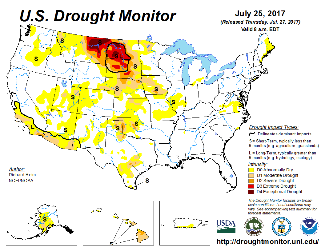
The US drought monitor shows those dry areas, as of last Thursday...


Looking down the road....

For those that have been following this blog for several years, you know that I don't like to make late fall and winter predictions until the pattern establishes - which takes a month or so. The "new" pattern (unrelated to the previous spring/summer, etc.) begins to form during October, or as the jet stream starts intensifying across the northern hemisphere.  Pattern recognition does not really show up until sometime in November. There will be several areas of forcing for the new pattern such as the equatorial Pacific, north Pacific, north Atlantic, land masses being impacted by early snow and ice (higher latitudes), the Arctic Oscillation, North Atlantic Oscillation, small scale interactions that really are not too detectable, etc, etc.

One area that has shown it's early hand, is the robust MJO.  Will this continue off-and-on throughout the winter?  It's something I will watch carefully.  If it does, it would favor occasional periods where storms would intensify into the southwest U.S (usually a wetter signal).   But then the cooling for the equatorial Pacific somewhat signals a drier pattern. The ocean water configuration across the northern Pacific would favor occasional amplification of the jetstream across far western Canada, which could dislodge Arctic air into the states.   But then there was an early indication of a "brief" signal of low pressure across the Arctic, which does NOT favor cold for the high plains.  Thus, there are conflicting signals! The only indicator to go off of is perhaps an analog year, which really isn't statistically that significant.   So what I'm saying is that it is entirely too soon to make a prediction based on anything concrete and scientifically based.

You want a wild guess for the high plains?

Here is my gut spewing, subject to much change after the pattern shows itself....

For the high plains....

Early fall - drier than normal for an average.  Temperatures near to above on average (but with some brief cold).

Late fall - near normal precipitation on average.  Temperatures near to below on average.

Winter (Dec-Feb) - near to above normal precipitation on average.  Temperatures near average but with a couple of bitter periods (short lived).

Spring - I have no clue - ok, I'll guess normal precip and temperatures

Summer - drier and hotter than normal.

Remember - that's just a big ol' guess at this point! 

Once the pattern establishes and starts repeating, then I'll fine tune (and probably completely change my guess).  Your turn...


Saturday, October 7, 2017

Quick post - 10/07/17

I wish I had more time to post but it's not possible, for now.  Since the previous posting I did on the 26th of September, there have been several rounds of precipitation across the area.  Some locations got too much rain (flooding 4 to 6 inches rains in one event and more than 10 inches in the past 2 weeks), others did not get much nearly as much.  But that is the nature of convective events.

The storms that moved through late Friday (6th) unfortunately brought high wind and large destructive hail to some areas.  Other locations got a lot more rain again.  Some not so much or nothing.  Again, that is the nature of convective precipitation.

Here is a map of rainfall over the past 14 days....(click for a large version)


You might be hearing talk about a freeze this coming week.  Indeed a cold shot will be dropping across the plains (not unusual for early-mid October) but I'm NOT seeing a widespread freeze.  I'm sure there will be low lying areas that get down to around 32 and I'm sure there will be some frost at some locations. But it's not going to be a widespread killing and growing season ending freeze.  I still think (as I have posted about the past month or so) that the first widespread season ending cold will be later in the month.

Although there will be scattered showers Sunday night or Monday with the cold front, amounts will be light.  Then we should see a drying trend the remainder of the week.

I'll be at the 3i Show this next week and doing a table top exercise early in the week.  So, I won't have a chance to update this blog until the following week.  The "new" weather pattern is getting established now (and into November) so I'll be gathering some thoughts on what to expect going into winter and into next growing season.  Stay tuned.

Tuesday, September 26, 2017

Quick Update - 09/26/17

Just a quick update.  In the post I did on the 22nd I mentioned the "storm" we just experienced across Kansas.  This is what I said "A few unlucky locations across the high plains will get less than 1/2 of an inch of rain through Monday.  But, some locations will get more than 3 inches through Monday!  It all depends on individual storms and their locations." Well it looks like a few areas "only" got 3/4 to 1 inch but for the most part it was a widespread 1 to 3 inch rain event!  There were quite a few locations that got more than 4 inches.  There were a few 5 to 6 inch reports near Preston and Pratt county.  Here is the map of the 3 day accumulated rainfall (click for a larger version if you want):


The heavier rains will shift into west Texas for the remainder of the week as another system approaches.  Even New Mexico and southern Colorado should benefit. There is a small chance the system gets close enough to Kansas to bring rains back into western Kansas. 

Here is the latest outlook through early next week from the Weather Prediction Center:


Temperatures will remain on the cool side into the weekend.

I'll try and update again next week.

Friday, September 22, 2017

Update on 9/22/17

So far for September it has been very dry for most areas and unfortunately hot and windy at times.  Because of those conditions, the developing drought has expanded. Here is the latest drought monitor map
In the previous post I did on the 7th (read it by clicking here) I mentioned small opportunities for rain around mid-month and there was at least scattered thunderstorms then.  Some locations got a pretty good amount of rain, but most got very little or nothing.


I also mentioned that there were tiny indications for something towards the last week of the month.  That time is now and it "looks" like many areas will benefit.

Here is the latest satellite image....


This appears to be somewhat of a developing pattern as winds aloft begin a slow increase in magnitude.  Every fall a new weather pattern will develop across the northern hemisphere, sometime after the fall equinox.  Once it gets established and set, the pattern will begin an oscillation in time and space and often repeats at a specific frequencies (most often from 40 to 60 days).  That frequency will be unknown until November and maybe even December.

Regardless, this first change in the atmospheric flow will bring several rounds of showers and thunderstorms.  Here is the latest outlook from the Weather Prediction Center....


Don't concentrate on only the amounts or the locations of minimum and maximum amounts.  This is just a general idea of how much rain might fall.  A few unlucky locations across the high plains will get less than 1/2 of an inch of rain through Monday.  But, some locations will get more than 3 inches through Monday!  It all depends on individual storms and their locations.  Through the end of next week it appears parts of west, central and southwest Texas will get deluged!

Even though there will finally be a break in the very warm temperatures starting this weekend, a killing freeze is not showing up.  I still feel the first one will at or after the average date.  Meaning at least mid/late October.  Remember though, the NEW pattern is setting up so there is still some uncertainty.

I will go into an outlook in the next post, but unfortunately I won't have  chance to do that until the first week of October (most likely).


Thursday, September 7, 2017

Update 09/07/17


Obviously the biggest news is the eventual impacts on the southeast U.S. from Hurricane Irma.  For the High Plains (which this blog is about) - nothing from Irma (weather wise).  I do feel  there could be impacts economically from the ripple effect since there WILL be devastation on the mainland.  Just don't know exactly where yet.  Anyway....

In the previous post I did on the 29th (read it by clicking here) I discussed the dramatic change in the pattern across the plains.  There was a weak storm system on the 1st that did bring some beneficial rain to areas of western Kansas.  But the majority received nothing or very little.  Here is the latest drought monitor: (click for a larger version)


As you can see, dry areas have been increasingly getting drier.  Not a good trend.  At this point I don't see much change through at least September 15, although there will still be a few small chances for widely scattered thunderstorms during that period.  There are some tiny indications of a deep system moving into the Rockies mid-September but that would "probably" benefit the northern areas of the high plains.  Don't count on it.  There is also very tiny indications of a few better opportunities towards the last week of September.  Again, don't count on it.  Overall it's looking like September will be drier than average for MOST of the area.  

I'll have to post on the summer precipitation in the next blog entry (around the 18th/19th).

Tuesday, August 29, 2017

Update - 08/29/17

What has happened to the pattern?  Well, it's now late enough in the summer that the upper atmospheric wind currents have reached their lowest average magnitudes (averaged across the northern hemisphere).  The general pattern that developed last fall is falling apart and won't start reorganizing for another 4 to 6 weeks.  I really hope that what we have now persists for that long (i.e., limited rainfall through September).

Since the last post on the 17th (read it by clicking here), the following is the accumulated rainfall:


That is quite a range of totals across the high plains (and especially eastern Kansas and western Missouri).

Here is the latest satellite image:


The North American Monsoon is GONE!  There continues to be scattered late afternoon high terrain showers and storms, only because of the residual moisture.  But the flow from the deep tropics into the west has ceased.  It could come back briefly before the end of September.  Also, the upper ridge across the Rockies is about as strong and robust as it has been all summer.  The resultant flow aloft across the high plains is north to south.  Surface moisture has dried out considerably.  This is partly due to "Harvey" that has pounded Texas and Louisiana. Usually a system in that area of the Gulf states plus the presence of a big upper ridge across the west is detrimental to the high plains receiving any rain.  Since the remnants of Harvey are slow moving, I don't see much hope for improvement in rain chances for at least a week (or more).  So, those areas that have really dried out lately will suffer.

Here is the outlook from the Weather Prediction Center:


BTW, next week or maybe even this Friday I will post about the summer rainfall for the high plains.  It's going to show a remarkable difference across short distances.  More on that later.

Finally, a look at the latest US Drought Monitor.  Some areas have improved, some have gotten drier.


I'll be discussing the fall outlook (and into winter) sometime in September.  I have a week long conference coming up in a couple of weeks and some other issues that need attention, so I'm not sure when I can get to that.  Stay tuned.

Thursday, August 17, 2017

Quick update - 08/17/17

In the post I did on Monday the 14th (read it by clicking here) I discussed the notion that the high plains was going to have an early fall - others ideas, not mine.   More on that towards the end of the post.

First, even though there was "some" rain across the western corn belt, drought conditions have worsened in the past week. Here is the latest available:

There was improvement across TX and OK at least.

For the next week (through August 24) the Weather Prediction Center is expecting some improvement across the corn belt - or at least some rain and with a return of the North American Monsoon (note the precip from Mexico into Colorado).

Back to the "early fall".  I've talked to several folks that are under the assumption that since it's been relatively cool and wet across much of the high plains since the last week of July, that an early fall was in the offing.  I'm assuming they mean we'll have an early freeze.

As I've stated numerous times in this blog, the pattern that produces the spring and summer weather, will change completely during the fall.  Having said that, I wanted to look at some numbers. 

The dramatic cool-down began on July 27 for the high plains.  For "most" of the area, it has been relatively cool and wet since then.   For Dodge City, the average temperature from July 27 through August 17 was about 4 1/2 degrees below normal. Going back since 1875 and looking at that exact period, this year ranks as the 18th coolest.   I took the top 15 coolest periods (again July 27 through August 17) for Dodge City and then looked at when the first freeze (32 degrees) occurred.   The result? On average, the first freezing temperature occurred 7.6 days after the 1981-2010 climatological average.  Only 3 of those years had an "early" freeze, and October 9 was the earliest date.  The first 28 degree temperature (killing freeze) occurred on average 2.7 degrees later than normal.  So what this says, is that based solely on climatology and with a similar cool late July and early August, there most likely will NOT be an early freeze.  Again, the pattern starts to change during the fall so at this point it's impossible to forecast.  Just a guess based on history. 

Here is the graph of those numbers.


Monday, August 14, 2017

Update - 08/14/17

Catching my breath, I can at least briefly post. 

The North American Monsoon (partly responsible for the high plains wetness) has abated, at least temporarily.  More on that below.  First...

Over the past 14 days, there have been incredible amounts of rainfall (August standards) for many locations across the high plains.  BUT, there continues to be those unfortunate ones that keep missing out.  One area is from near Dodge City to Concordia.  You can see that during the past 14 days, there are those heavy rainfall amounts but also the areas that have missed out.  Click on the map for a large (very large) image:


Unfortunately, there has also been a rash of very severe thunderstorms.  The hail and wind across the I-70 corridor on Thursday and also across Barber county on Wednesday was particularity bad.  Supercells (that produced the severe weather) of this magnitude are not unheard of for early August, but relatively rare.

Because of those that have missed out, moderate drought conditions have developed across the central third of Kansas and down into Oklahoma.  The western corn belt and into much of Iowa is getting progressively drier too, although there were some big rains over the weekend at some locations. Here is the latest drought monitor (as of August 8)


Looking at the latest satellite image...

 
Most notably was an anomalously strong upper level system across the western U.S..  The jet stream associated with this system was dipping pretty sharply south!  As this system moves out int the plains later in the week, there should be another a pretty big warmup for the northern plains followed by a cool down.  For the high plains, the result will be a boundary that will be part of the equation that will bring additional chances for thunderstorms.  This time it looks like areas farther east will be targeted, hopefully helping a bit with the moderate drought area.  Here is the latest thinking from the Weather Prediction Center....

I'm not sure if the NA Monsoon will return as strong as it has been during the summer, but it may not matter too much since the grounds are relatively wet and green across much of the high plains.  We'll see, but I would suspect that things will start drying out as September approaches.  You might know what that means.  Just like last year, take advantage of early top moisture for fall planting (for those that have benefited this summer anyway).

I've heard lately from a "lot" of people that because it's been wet and considerably cooler than normal during the past 3 weeks that we're going to have an early fall.  I'm taking that an early freeze would be expected - at least that's what they are saying. 

However, summer weather patterns usually have very little to do with the weather during the following fall (and especially into the winter).  Having said that, I did a really quick glance (since 1875) of late summers (late July into mid August) that were wet and "cold" at Dodge City and found that a very high percentage of those years actually had normal to late first freezes.  I'll do a little more digging into the past data and post here, maybe by Thursday (17th).


Friday, July 28, 2017

Short Update - 07/28/17

This will have to be relatively brief again.  The North American Monsoon that got going about 3 weeks ago has been very robust across the western U.S. and the Rockies and has benefited the central U.S. at times with periodic cooler temperatures and precipitation.  One of the disturbances that was generated from the pattern impacted the Kansas City area a few days ago producing record flash flooding.  Looking at the central U.S., there are areas that received very substantial rains while other areas not too far away have in general missed out.  Those lucky ones that planted dry land corn and have also got the timely rains could use another drink and it looks like they just might be in luck.  The very hot temperatures have only lasted 3 to 4 days before brief cool downs occurred, as was expected.

First, the next two images shows the precipitation that has been observed the past 2 weeks, along with the departure from normal.  Obviously it has really dried out across a lot of the area, but there is also those areas that continue to be wet.


Looking at the satellite image, there is a relatively strong disturbance (the red X across Nevada) that is going to ride across the big upper high that was in place across Oklahoma.  This should help to enhance the overall coverage of showers and thunderstorms, especially Saturday night and Sunday.  The pattern will continue to waffle back and forth going into at least the first week of August.  This means that there will be a periodic chance for additional rains.  At this point, I'm not seeing much indication of the really hot air anytime soon.  In fact temperatures in general will be below average for at least a week.


Here is the expected precipitation during the next 7 days.


As far as the drought, much of the dry area across the panhandles may be wiped out during this wet period coming up.  Farther north, not much luck for the  drought hammered northern plains.  Even for Iowa things are looking a little bleak at the moment.


I'll see if I can write up something again by the end of next week.

Cheers.

Wednesday, July 12, 2017

Typical Summer weather - Updated 07/12/17

The current pattern is rather typical for this time of year.  The North American Monsoon has been established, for now, and cranking up pretty good!  Historically it usually will benefit at least some of the high plains.  That has already occurred with scattered thunderstorms across eastern Colorado and northwest Kansas on Tuesday.  As the upper high meanders from the Rockies to the Mississippi Valley, temperatures will be up and down.  The hottest will likely be as the high is overhead and cloud cover is at a minimum.  Here is the latest satellite image from this morning....(click for a larger image)


 During the next 10 days or so, very little will change in the overall scheme of things.  The issue for the corn across the central part of the country will be the hotter temperatures (over 100) occurring at the wrong time (for pollination).  At least I don't see an extended period of 7 to 10 days of 100+, meaning there should be brief breaks.

Here is the Weather Prediction Center's outlook on precipitation through  next Wednesday to 19th...


Unfortunately for much of the Dakota's where the drought is expanding, the outlook for a lot of rain up there is very small.  Here is the latest US drought monitor...


As far as what has fallen during the past 2 weeks...first for much of the corn belt....


And for the high plains....


I'll be a county fairs next week so won't have a chance for an update until probably the 24th.


Wednesday, June 28, 2017

How ironic - Updated 06/28/17

Moderate drought conditions have been creeping up on northern Missouri.  Here is the latest map for that area:

Then, the following is what is expected over the next 7 days.  Ha!  The heaviest rain is predicted to be in that same location!  This also happened in late April wiping out the drought in southern Missouri, Arkansas and eastern Oklahoma.  The only real area of concern is Montana and North Dakota.


So far, from what I posted on the 23rd (you can read it by clicking here) there really is no change.   I should have some time to go into more detail by the end of next week.  Hopefully most will get the wheat harvested by then. 

Friday, June 23, 2017

Cooler-Hotter-Cooler-Hotter Update 6/23/17

After a brief warmup this week with upper 90s and a little over 100 (with wind), a significant cold front moved through this Friday morning.  Temperatures through the weekend will be some 15-25 degrees below normal!  The pattern that brought this cooler air also was responsible for the thunderstorms this week.  Quite unfortunately, the wind patterns from the surface to the higher levels were very conducive to produce supercell thunderstorms, capable of producing giant hail and wind.  There were good rains though, except that not all locations got wet.  Here is a map of rainfall during the past 7 days:

The best chance for thunderstorms with this current break in the heat will shift into southern Colorado, New Mexico, Texas and Oklahoma through this weekend.  But, then the pattern will shift north again bringing opportunities for thunderstorms into northeast Colorado, Kansas and Nebraska.  And then by the end of next week we're probably going to be back into the really hot air again.  There will be storm chances throughout the week, especially early but then shifting north with the heat.  Here is the precipitation outlook through early next Friday...


I still feel that the pattern won't get "stuck" going into much of July.  Meaning that the hot and dry will be offset by periods of cooler and chances for storms.  I'll try and get a little more detail later next week.

Monday, June 19, 2017

Summertime weather - Updated 06/19/17

As expected (or feared), the weather made a sudden change to a summertime pattern.  A huge upper level ridge/high has set up over the Four Corners region.  Unfortunately for much of the high plains, temperatures in the middle levels of the atmosphere have warmed enough to prevent much in the way of thunderstorms, at least widespread.  Now, what you see on the satellite image below, is actually a favorable pattern to get the North American Monsoon going (in 2-3 weeks).   This upper high (the big ol' ugly blue H) will meander back to the west or even south and southeast at times and will lose it's magnitude too at times.  What this results in is occasional northwest flow events allowing thunderstorm complexes to move into the high plains.  For the next several weeks there will be periods of "turning hot", brief cool downs (significant at times), dry stretches but intermixed with a few opportunities for thunderstorms.  At least it's NOT a "hot and dry for the foreseeable future".

Here is that satellite image:


We just went through one of the hot and dry periods, especially across parts of the panhandles, eastern Colorado and southwest Kansas.  Then one of those brief cool downs occurred yesterday and today.  The flow aloft will be conducive for a few thunderstorm complexes this week, especially during the evening and overnight hours as that high has shifted slightly west.  Unfortunately (or fortunately for those still cutting) not everyone will get much rain. 

The following map shows how much rain has fallen the past 14 days.  As you can see (or probably already know), many areas have received very little or nothing at all. 

Click for a larger version.

After hot temperatures, especially the last half of this week, the high will be suppressed and will shift southwest.  This will allow another cool down this weekend and into next week.  This next cool down will be even cooler than what came through yesterday and today.  That could favor better chances for rain across Texas and eastern New Mexico.  However, this time of year differences can occur easily with just minor changes in the flow (surface and aloft).

Here is the latest outlook from the Weather Prediction Center for the "average" amount of rainfall possible through this coming weekend.  Some will get more, some less (or much less):

  I'll try and update again by the end of the week.