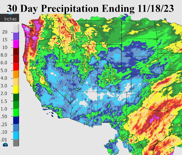
The weather pattern has been flipping between a La Nina response like upper flow and then showing signs recently of a "typical" El Nino weather pattern with rain and snow into California and wetness across southern Texas. Here is the precipitation accumulation for the past month ending the morning of November 18 (and notice the tremendous precipitation accumulation across the northwest U.S., atypical of an El Nino pattern...
If you look at indices of ENSO, then one could argue that a true El Nino (at least a strong one as we have been led to believe) is not in place, at least yet. Sure the equatorial waters of the Pacific support an ongoing El Nino by looking at the Oceanic Niño Index (ONI) three month average where the warmest waters have been in the Nino 1+2 region. But the Multivariate ENSO Index (MEI) and the Southern Oscillation Index (SOI) do not support a true El Nino. One issue has been the warmer than average waters across the mid and high latitudes of the Pacific. The atmosphere has responded at times with storms slamming into the Pacific Northwest and across the northern Rockies and northern Plains. Recently California has joined in the action (more of an equatorial Pacific contribution). Where does that leave us in the plains for the rest of the fall and through the winter? Will the plains benefit from a transition to a more typical El Nino pattern, or will it be back to the drought for those that got the good rains this summer?
For subscribers to Hutton Weather Futures weekly weather outlook reports, those questions will be answered. Although there have been discouraging signs with this weather pattern, I'm seeing some promise buried in the data! But a lot will have to come together before I know for certain that improvement will be made in terms of soil moisture across a large chunk of the region.
To subscribe for weekly reports, go to https://huttonweatherfutures.com for more information.