Thursday, February 23, 2023

Update 02/23/23

As a reminder I will only be updating this blog site on occasion as I move forward with my consulting company, Hutton Weather Futures LLC.  I will provide more detail in outlooks emailed to subscribers and the reports will of course be much more frequent as a subscription service.  That web address is https://huttonweatherfutures.com/  

As I have mentioned in the reports I have been emailing to my customers, weather systems in this current pattern are on schedule.  The next system that I have targeted is for late this weekend.  It will likely be the first severe weather "outbreak" for the central part of the country.  Rainfall on the west end will be limited once again but may be farther west this time.

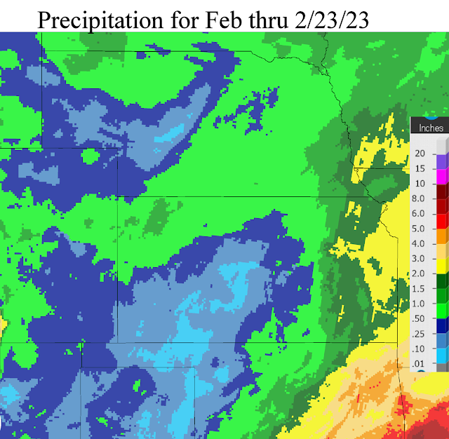
So far for February, the results from the active pattern have been nearly the same (eastern areas benefiting greatly).  Here is a map of precipitation that has fallen this month (February)....


Other systems are due periodically in March with one in particular expected around the spring equinox. 

Hopefully you will consider subscribing to my consulting update reports as I'm certain I can provide useful information (inputs) into making your crop and livestock production profitable.  

Wednesday, February 1, 2023

Weather Systems are on schedule?

 First - if you haven't been visiting this blog site lately, please review the one I did on January 20 (click here) to read up on how this blog will be handled going forward.  With my consulting company, Hutton Weather Futures LLC, I will provide more detail in outlooks emailed to subscribers and the reports will of course be much more frequent as a subscription service.  That web address is https://huttonweatherfutures.com/.  I will only occasionally update this blog site "swkswx.blogspot.com". 

As I have mentioned in the reports I have been emailing to my customers, weather systems in this current pattern are on schedule.  The next system that I have targeted for February 7-8 has been showing up in some of the long-range computer forecast models but with inconsistent timing and inconsistent features.  Confidence is fairly high that there will be impacts across parts of the Great Plains.  Details at this point are uncertain.

Looking at the current upper air map, any potential storm for next week is not really showing up on this map at least as of Wednesday evening (1st)....


The storm moving across northern Mexico has been weakening but still very capable of producing a widespread precipitation event from southwest Texas and eventually into the lower Mississippi Valley.  It is way too far south to impact the central plains.   The strong system across the eastern Pacific (the big red L) will be moving northeast into Canada and will only promote warming for the central plains but with no indication of any moisture.

Any potential storm next week hopefully will benefit the area that has been consistently getting missed as you can see in the precipitation maps for January (the first is the amount and 2nd is the precent of normal).


For January that is a hefty amount of precipitation for Nebraska and northwest Kansas!

Again, I have started the subscription service at https://huttonweatherfutures.com.  I hope you will consider subscribing and join the others receiving these frequent updates of the expected weather as we get into the growing season.