Wednesday, December 30, 2015

California finally catches a break? Updated 12/30/15

In the post I did on the 28th (read it here) I gave a wrap-up of the significant winter storm (that just happened to miss much of Kansas).   Look at the lack of snow...

I could blog about the specifics of the storm and what it did and didn't do and have a really, really long reading.  But I won't this time.

But I do want to remind everyone that weather systems are not a solid object that can be coherently tracked from one location to another.  Weather is NOT one dimensional and is NOT a solid, but rather is 3D (can argue it's actually 4D) and is a fluid that changes continually.  There are around 100 tredecillion (that is a 1 with 44 zeros) molecules that make up the atmosphere.  Computer forecast models attempt to track some of these molecules that are governed by such things as Newton's 2nd Law of Motion, the Ideal Gas Law, Equation of Vertical Motion, Equation of Continuity, First Law of Thermodynamics, etc, etc..  Expert Meteorologists are forced to absorb a torrent of information to make predictions as accurate as possible. That is dealing with a small fraction of the 2.5 quintillion bytes of information that is generated each day - the equivalent of the entire printed collection of the Library of Congress about 3 time per second.

Like a baseball umpire, a weather forecaster rarely gets credit for getting the call right.  So be it.

Go back to posts I did during the late fall.  I had concerns that the "El Nino" would not benefit California until later in the winter.  It looks like that is finally starting to happen.  I can argue that this past Christmas weekend storm could have been influenced heavily by the beginning of these changes. 

Looking at the afternoon satellite image...


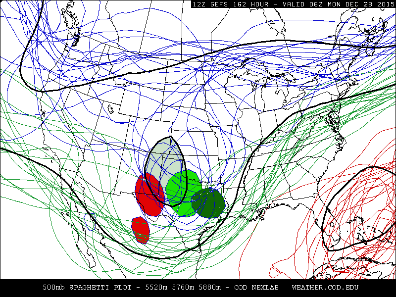
The upper air flow has recently become chaotic.  There is still flow across the central U.S. with minor disturbances that will likely keep cloudiness across much of the area for a few more days.  There was a disturbance (the X across western Canada) that was dropping south that will intensify but should get cut off and meander around the NW U.S. for a while.  The reason it will cut off is the split in the jet stream that is developing (likely because of the strong south to north jetstream that has developed out of the tropics and into Alaska).

The significant changes

There is a new East Asian jetstream that has expanded across the Pacific, but this time much farther south!  The reason for this is a VERY robust Madden Julian Oscillation (MJO).  In fact, looking at a phase-space analysis of this MJO, it is 2 1/2 to 3 standard deviations above normal.  Unreal and significant!  Here is that chart...


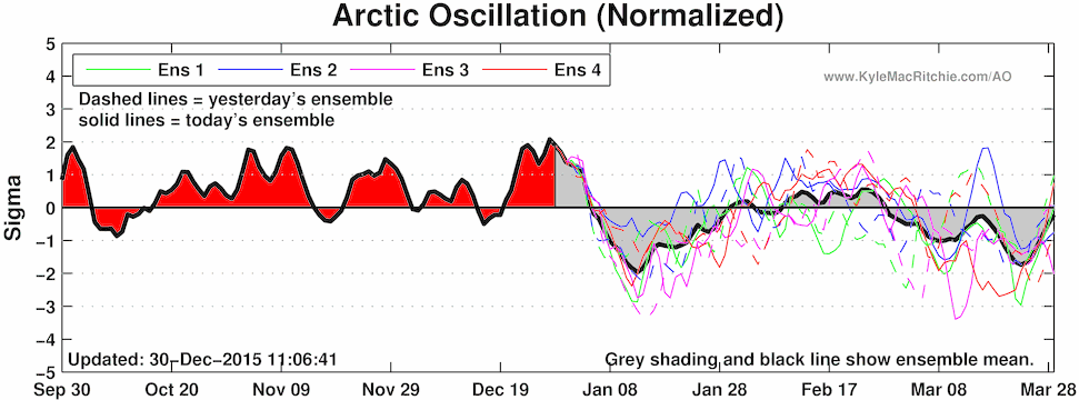
At the same time the Arctic Oscillation is forecast to crash (maybe in the wake of the very temporary storm going through that region raising temperatures)?


So what does this all mean?

The nature of the weather pattern generated early this fall from different source regions forcing the jet stream into a cycling pattern, is set to favor the jet stream to dip into the western U.S. again.  The first evidence of this will be the East Asian jetstream that will bring a significant precipitation event to all of  California.  Look at the prediction from WPC...

 
This system will move out into the central and southern plains late in the weekend or first of next week, but will also be weakening as it does.  There could be a bit of light precipitation for the high plains but it should not be too significant.   I've been expecting a pretty strong storm sometime afternoon the first of the year for some time (centering on late in the first week).  With all the changes going on across the Pacific and with the timing of the pattern, there may very well be a decent storm somewhere around the 7th (give or take a few days).  Nothing is really showing up right now, but that may be changing.  I won't have a chance to post here until probably the 3rd or 4th, so check back then and I'll update on the prospects of the possible storm AND a turn to sharply colder by mid-month.

Monday, December 28, 2015

Update - 12/28/15

What a storm!  From an epic blizzard across eastern New Mexico and far west Texas, to an outbreak of killer tornadoes (at least one an EF4), to record breaking rainfall and extensive flooding!  And then, NOTHING for much of western Kansas and eastern Colorado!  If you have read this blog, or if you haven't (go back and read the past few posts), you will know how much uncertainty there was on the track of this particular storm.

The pattern had been set and an ocean/atmosphere forcing pattern was in place to produce an intense storm that was expected to occur between Christmas and the last few days of the month (I had discussed this several times during the past month).  Computer models started to "hint" at this possibility as early as December 12.  That really was no surprise.  But thanks to the internet, one individual chose to post this one specific solution and it went viral (indicating Dodge City would get 25.7 inches of snow, for instance), and was forever etched in the human mind.  Then for about a week the same computer model showed absolutely nothing, anywhere including West Texas. Again, not surprising as it (flip flopping) happens frequently.

As we got 3 days out, the computer models were showing that the storm would reach maximum intensity somewhere near El Paso and then move east and north from there.  The forecasting problems were many - where would it track, where would the surface response occur, how much cold air would be in place, what would the temperature profile be above the surface, etc., etc..  This particular system had an insane amount of boundary layer moisture to work with.  Low 70 dew points had moved into southeast Oklahoma.  For late December, that is almost unheard of!

When I provided a forecast, I told people that the range of possibilities (for southwest Kansas) were huge, ranging from several feet of snow to virtually nothing!  Why such a large range?  Because for this storm, it would have everything needed to produce an epic amount of snow and wind and could very well track into Kansas.  But at the same time, there was evidence that it would track too far south to produce much in western Kansas.  Even as of the 26th, there was still concern that it would be close enough.  In the post I did on the 26th (read it here), I showed two possible tracks (1 and 2). Obviously it took track #2.  Nobody should have a problem by preparing for a very high impact winter storm, that could have rivaled the January 1886 or the March 1957 blizzard.  The folks of eastern New Mexico and far West Texas probably have a different opinion compared to farther north.

I'm hearing reports that there are still stranded motorists on some roads of eastern New Mexico. Hopefully nobody died in the blizzard.

The following map shows how much precipitation has fallen the past few days.  Epic!


That is 10 to 15 inches of rain across eastern Oklahoma, Arkansas and Missouri!  That is extreme for any month, let alone December.  There may actually be some concern for the reservoirs in these areas being capable of controlling the massive runoff.

As of this morning, here is the satellite image of the storm.


The red dashed line is the track the upper system took...or the southern track.  Also, the storm ingested dry air from the north and made the impacts (as it moved out) a little smaller/tighter.  In the previous posting I discussed the "kicker" and that has dropped into central California as of this writing.

The "kicker" system will move into the plains later Tuesday or early Wednesday.  The system will be lacking moisture to work with but could still produce a small amount of precipitation (most likely snow) but it does not appear to be a big event at all.

Looking ahead into the first of the year, I've been expecting another storm not too far into the first of the year, but I'll have to analyze the situation once I get back to work.  Stay tuned for that one. Overall it should be an active January - and likely colder as well.

Saturday, December 26, 2015

Update 12/26/15 (time sensitive)

This post is time sensitive and will quickly become outdated due to the nature of the December storm that is impacting the central southern parts of the U.S..  Please rely on the National Weather Service for updated specifics for your area.  You will continue to see varying amounts of snow, ice, and rain amounts forecast by different entities (the media sure seems to enjoy this)!

The late afternoon radar showed a huge of rain and thunderstorms spreading north.


As has been expected, the "storm" has intensified into a tight upper level low as depicted by the satellite image from this Saturday afternoon.


There was a deep and moist fetch of air from the tropical regions into Texas and out across the midwest.  An INCREDIBLE amount of boundary layer moisture had moved north into southern Oklahoma.  Dew point temperatures had risen into the lower 70s as far as southeast Oklahoma.  This could be unprecedented for December 26.  As a result, copious amount of rain along with tornadic thunderstorms have already occurred and will continue to be a threat. The surface map following below shows where the front had ended up (north winds on the poleward side, south winds on the equator side of the boundary).


Back to the satellite image.  There is still some uncertainty of the eventual movement of the upper level low with the storm.  The system has not reached it's maximum intensity so could still change directions pretty easily.  Some of the computer guidance suggests that the low will track as depicted by #2 while a handful of other computer models suggest a track closer to #1.  This will have a huge impact on the eventual snow or ice across Kansas.  For west Texas and the panhandle and eastern New Mexico, it appears pretty certain that there will be a major blizzard.  Again, check weather.gov for details for your specific area (click on the map that pops up).

Back to the track.  If the storm eventually turns more like track number 1, the snow amounts will ramp up farther northwest, perhaps into southeast Colorado.  If the track is more like number 2, the snow amounts, for say Dodge City, will be much, much less.  Again, check the NWS products for the details. There will also be heavy sleet on the east side of the snow area.

Another thing that is certain is the extremely high amounts of rainfall that is expected.  Look at the Weather Prediction Center forecast!  This is absolutely incredible for any month, let alone the last part of December.


Sleet and some snow will also spread into eastern Kansas as the storm departs on Monday.

I'll try and update again on Sunday or Monday.

Looking ahead, there could still be a weather maker just after the first of the year.  I'll try and nail down timing of this later in the week.  I've talked about that possibility in the blog several times now so it would fit the pattern.

Thursday, December 24, 2015

Quick update - 12/24/15

Please read the post I did yesterday (click here).

The "storm" is definitely intensifying as expected, but the eventual track and strength is unknown since it STILL was not over the CONUS where weather balloons would be able to sample the atmosphere.  What does this mean?  It means that specific details on the sensible weather that will occur across the plains and adjacent areas is absolutely impossible to nail down with any confidence!  For instance, if you are seeing specific amounts from different sources (the TV weather people are a prime example of this), then these specifics are nothing more than a wild guess.   I know it's hard to prepare for something unknown.  Maybe it's best just to plan for a worst-case-scenario.

Looking at the late afternoon satellite image (go back and compare to the satellite image from yesterday too)....there are several notable features.


X1 has undergone significant development since Wednesday (as was expected) and was becoming pretty intense.   It is this system that will cause the issues.  X2 has dropped south and has pumped up the ridge (blue line) that has contributed to the development of X1.  Now there is an X3 that will become a player.  Let me explain.

X1 will continue to undergo development and become an intense upper low.  There remains a huge question mark about how far south it will go before turning east.  If it turns east too far south, it will keep major winter precipitation out of eastern Colorado and western Kansas and limit the white chaos to areas of eastern New Mexico and west Texas.  If it turns northeast, then much of the high plains will get clobbered and this could extend into other parts of Oklahoma and Kansas.  X3 will be the mechanism that "could" force X1 to turn more northerly.  Confused? 

Bottom line...the most favored area for heavy snow (and likely blizzard conditions) for late in the weekend is probably from near Lubbock to Amarillo and into far western Oklahoma.  But, areas farther north CANNOT be ruled out yet because the eventual track is still unknown.  By late Christmas morning or early afternoon, the situation "should" become a bit clearer.  I might have time to do a quick update, but it's best to just rely on information out of the National Weather Service.

One final bit of info...this system will cause extreme rainfall in the warm sector.  Look at the precipitation map from the Weather Prediction Center. WOW!  There will be major flooding in those areas that receive the extreme rain amounts.


Wednesday, December 23, 2015

Update about the "storm"

Please review the previous post I did on Monday to give you a sense what we're dealing with on this upcoming winter storm.  You can read that post by clicking here.

Unfortunately there are STILL many possibilities with the outcome of this weekend/early week storm.  The main reason is that the storm isn't even a storm yet.  Look at this afternoons satellite image.


The evolution of this potential major winter storm will be VERY complicated!  As of Wednesday afternoon it was only small upper level system over the Gulf of Alaska.  On the satellite image it is denoted by the X1.  The key will be upstream!  There was a deep upper system (denoted by the X2) that was forcing "warm" air north across the Aleutians.  We call this upper level ridging.   This ridging was also phased with ridging along the dashed line extending southeast.  Both the X2 system and this subsequent ridging is directly tied to the MJO that I talked about in the previous post!

X1 will undergo significant development as it dives southeast and again the influences from X2 and it's ridging will determine this eventual development.  If X1 was over the CONUS it would be sampled by weather balloons and I would have a better idea of the this development.

So, as of now (Wednesday afternoon), there are still many, many questions and uncertainties.  It is unclear just how far south this storm will "dig" and then just how far it will get east before eventually  turning north.  Computer forecast models during the past 24 hours have been trending for a track  from northern Mexico to southeast Oklahoma (which is shifting south).  Because of the numerous questions and uncertainties, there really is just no way to get specific about the outcome of the sensible weather.  The range of possibilities is still very large!  But it is looking more likely that much of the precipitation from the eastern Texas Panhandle to central Kansas may fall as sleet or a mixture of sleet and freezing rain which will limit snow amounts.  It's impossible to say where the transition line from rain to sleet/freezing rain to snow will set up.  For NW KS there may be a nothing at all to some snow.  If this system does indeed move farther south, then the heaviest winter precipitation will be limited to the panhandle into central Kansas.  It could even end up being a huge sleet storm too!

The only advice I have at this point is just be prepared and pay close attention to the forecasts and statements that will be issued by the National Weather Service.  The TV stations and Facebook posts will continue to show the output from various forecast models and the output from them will change, perhaps dramatically every six hours.

I do feel confident that travel will become very treacherous from west Texas into central Kansas by Sunday/Monday and perhaps as early as Saturday night.  I'll try and update again sometime Thursday.


Monday, December 21, 2015

The STORM - here we go! Updated 12/21/15

On the 16th I blogged about a viral Facebook post that was circulating throughout the land.  You can read that discussion herePLEASE do read that discussion as I talked about computer models that attempt to forecast weather elements from 1 to 384 hours (and in some cases longer).

In that blog post I also discussed THE referenced graphic of the epic snowstorm that could occur on the 28th.  Since that time this same computer model has forecast absolutely nothing, rain, sleet and snow and anywhere from east central OK, central Texas to Nebraska.  It's a common occurrence for this to happen.  IF that particular model run would verify, it would do so by only dumb luck.  This person on Facebook that posted this model output has since shown almost every other output solution., except for the ones that showed nothing.  Remember, these forecast models will sometimes fail within the first 12 hours, let along 324 hours in the future!  But, sometimes (rarely) they can be close!

Also in that posting I did, you may recall that I said "ironically there could very well be a storm between Christmas and the last few days of December".  The pattern and current atmospheric forcing would lead me to believe the possibility.  That still does appear to be the case!

First, leading up to this "STORM".

In this afternoons satellite image, there were two features that may impact part of the plains states.


The first feature is the X1 over Washington...that feature is going to move rapidly south and east and could bring a few sprinkles to Kansas and Nebraska on Tuesday and snow to the northern Plains. The second feature, the X2, will dive into the plains by Wednesday and will bring additional light precipitation (mostly sprinkles) to the high plains but will become a strong storm for the midwest (liquid) and severe thunderstorms across the lower Mississippi Valley, including the possibility of tornadoes. 

Then attention turns to the STORM.  So, why did I say ironically there could be a storm after Christmas? 

First, the cycling pattern supports the jetstream diving into the Rockies at about that time (I've talked about these cycling patterns numerous times in this blog).  Second, the ocean temperatures and the location of tropical convection (forcing) also supports this diving, or digging, jetstream.

The Madden Julian Oscillation (MJO) supports this eventual transition.  The image below is what is called an MJO composite (there are different phases spaces that can be calculated)...


The transition from phase space 5 into phase space 6 for this time of year supports a trough of low pressure aloft located across the western U.S..

Looking at the satellite image from this afternoon...


The MJO was located across the Maritime Continents.  There was already a coherent response in the from of mirrored upper level flow (both northern and southern hemispheres).  The northern hemisphere flow was enhancing the "East Asian Jetstream" (the green line coming off eastern Asia).  The possible storm that could occur after Christmas was nothing more than a disturbed area in the flow aloft, marked by the X.

So what this means, is that this "X" certainly has the support from tropical forcing and extended East Asian Jetstream to "dig" into the western U.S. or Rockies by the weekend.  But, since this is still many days away, there is just no way to know exactly where the system will end up and how strong it will be.  But everything does support a vigorous storm, anywhere from south Texas to Nebraska.

The Global Forecast System ensemble forecast from this morning shows many possibilities by late Sunday.  Remember from my previous post, an ensemble forecast is attained by the computer model running with slightly different initial conditions.


What the above map shows is that there is still a huge range of possibilities for the position of the storm.  The black outlined light-green/grayed-in circle shows the composite (or average).   As we get closer to the event, I will have more confidence on what to go with.  The gulf of Mexico is very moist and warm and this system will have copious moisture to work with.  I'm very, very confident of flooding rains will occur across parts of eastern Texas, Oklahoma and the lower Mississippi Valley.  Depending on the track and evolution, heavy and flooding rains "could" also occur in Kansas and then the frozen stuff that will fall in the cold sector of the storm as the potential to be heavy.  Again, I'll get a little more specific as time approaches (I'll try and update later Wednesday or early Christmas Eve).  Follow weather.gov for updates (some offices are starting to talk about it).

Wednesday, December 16, 2015

Update - December 16, 2015 - Viral social media posts

In the post I did on the 8th (click here), I mentioned how computer forecast models, that attempt to predict various weather elements, often fail even 12 to 24 hours out.  By changing initial conditions (perhaps temperatures) just a tiny bit, there are often huge differences several days out.  These models are run with these different initial conditions to come up with what we call ensemble forecast solutions.  Often, 5 to 10 days out these different ensemble solutions overlaid on a map look like spaghetti. The following is an ensemble of 20 solutions at 384 hours out using 20 different initial conditions:


What the map shows is that 16 days out, the jet stream configuration could be just about anything. Each different possibility was arrived at by plugging in an initial condition with a small difference.  Essentially what this tells us is that computer forecast guidance that far into the future cannot account for small changes in those initial conditions and should not be used for decision making.  Often the "control" output or solution is plotted instead of the ensemble members.

That "control" solution often changes from run-to-run (computer forecast is generated every six hours), especially in the later periods.  It's nothing new, this has been going on since models have been developed.

Unfortunately, because of the access of this output via the internet and because of social media, these varying solutions can be posted and often are posted.  Take for instance what occurred Tuesday, December 15.  A person on Facebook (his page name is Oklahoma Weather Network) posted output from just ONE computer run from the Global Forecast System (GFS), which has a tendency of exaggerating output elements.  The solution was "off the charts" and he posted it as if it might really happen.  The post has gone viral being shared (as of the 16th) over 10,500 times and likely reaching 100's of thousands of unsuspecting persons.  I've been answering a bunch of e-mails, Facebook posts and text messages inquiring about this "storm".

The following should shed some light on what we're dealing with:

First - the "solution" at 324 hours out valid for 12 PM Monday, December 28 that went viral:


When the same computer model was run 12 hours later the solution for the date was completely different!
 

Then, it was run 12 hours later and now look!  NOT A BIT OF SNOW!


This is a common occurrence with these long range models!

If you have followed my blog, you know that I look for a cyclic pattern and look for areas of forcing (areas of latent heat releases from the oceans and others) to produce these weather patterns.  I'm close to nailing down the cycle length (48 to 52 days I think) but with intermediate cycles embedded in the overall pattern.  Using this information, there actually "could" be a storm around the 28th.  More on that at the end of this post.

December 12-13 storm

Several posts ago I discussed changes in the pattern that would favor storminess starting as early as December 12.  Due to personal obligations (nothing big - just a daughter getting married :-)) I didn't have time to post anything specific.  As you are aware the storm that impacted the center of the country on the 12th and 13th brought a variety of weather.  There was even one tornado reported in the Texas Panhandle!  The amount of rainfall with the storm was epic for December and I saw a couple of 5 inch amounts in central and north central Kansas!

The snowfall was limited to elevation and the temperature profile.  Had the temperatures been just 3 to 4 degrees colder there would have been over 2 feet of snow in some locations!  In Dodge City there was 8 to 9 inches and if the temperature had been just a degree colder and a little sooner there would have easily been 12 to 15 inches!  What a storm!  The following is the snowfall map and a map of the water equivalent or rainfall:


There are areas of southwest Kansas that have recorded over 40 inches of precipitation since the first of the year!  Unreal!  Parts of southeast Oklahoma and northeast Texas are approaching 90 inches for the year!

Here is the latest satellite image:


The green lines/arrows represent the jetstream.  This is actually a-typical of an El Nino!  The strongest and most moisture laden stream of air is slamming into the Pacific Northwest while a typical pattern would be pointed towards California.  I talked about this for months in this blog and to me it's not surprising.  (I still see it possibly changing over the winter).

This afternoon there was a small disturbance over Idaho (not depicted on the satellite map).  It will move southeast and head rapidly towards the central plains  early Thursday and should help to bring more snow to Colorado and perhaps a little bit to western Kansas.  It shouldn't amount to a lot.

There are other systems across the Pacific.  With the cycling pattern, I do see at least a small chance of a minor system around Christmas that could bring some rain or snow to the region.  The bigger storm may be between Christmas and the last days of December.  Then based on the pattern, an even bigger storm could occur the first week of January followed by a "brief" Arctic outbreak.

I'll try and nail down specifics in the next post that I hope to do this weekend or early next week.

Tuesday, December 8, 2015

Update 12/8/15

I'm a little preoccupied at the moment with my daughter getting married this weekend, so this post will be somewhat brief.

In the previous post I did on the 3rd (read it here) in the outlook portion, I said "starting around December 12 and persisting for a week or two, the weather pattern will get active and likely stormy across much of the western and central U.S."Those changes are on track and have been showing up recently on computer forecast models with numerous differences in spatial and temporal solutions.   Here in lies the problem...

There are several global long range computer forecast models.  Most are run every 6 hours with output to many weeks into the future.  The more notable are the GFS and the ECMWF (but there are others).  Many times these (and shorter range models) have numerous errors in the output (forecast elements) and as early as 12-24 hours out!  By 4 or 5 days out these solutions are completely wrong!  It is challenging to forecasters in determining what may or may not be right.

To give an example, the following two images are snowfall for a 48 hour period ending December 18th.  The first had a large area of heavy snow across Kansas.  Just 6 hours later when the same computer model processed data, the solution for the exact same time had absolutely nothing!


This is a common theme with forecast models, especially many days out.  Every 6 hours there typically is a large difference in many elements.

Over the next few days and more, you are going to see and hear of "rumors" of storms or no storms.  Many sources of weather you will see on the internet are often going to post this output, as if it is gospel truth!  For example, go to Accuweather.  Look at specific forecasts in the future.  Check back often and notice the changes for specific days.  Why is this?  Because they typically just post this computer model output.  Many others do the same (The Weather Channel for instance).

What I do is try to look for trends and find repeating patterns and then give the most likely solution.  At this point, since I've been wrapped up in personal issues, I don't have a really confident idea.  But as I stated in the December 3 post, I was and still do expect changes lending to unsettled weather.  From this weekend and for at least 2 weeks (perhaps even longer) there should be quite a few storms across the middle of the country.  Look for a turn to wetter and often colder weather.  Once I get past the wedding (and recover lol), I'll try and pin it down.  Enjoy the rest of this mild December week!

Thursday, December 3, 2015

Update - 12/3/2015

It's been really busy for me personally - thus the gap in postings.


In the last entry I did (read it here) I discussed the well advertised "Thanksgiving storm".   In the end, the freezing precipitation got farther east and south than originally expected.  Major accumulations of ice were noted at many locations across Oklahoma and Kansas.  Liquid, freezing and frozen precipitation amounts were record breakers at some observation sites.  As the storm system finally lifted out of the Rockies and across the midwest, it brought heavy snows to the upper midwest.  All told, the storm system brought copious amounts of moisture.  Here is the estimated precipitation map:

Parts of southeast Oklahoma and northeast Texas are approaching 85 inches of precipitation for the year!  Unreal!

What's next?

In previous posts at various times this past year, I have discussed the weather pattern that establishes in the fall and persists well into the following summer.   I encourage you to go back through some of those postings to get an idea of what I'm faced with in determining the pattern.  Unfortunately, I still don't have a clear and obvious signal, but it's getting closer.  There are apparently intermediate harmonics that formed and which may contribute to a great deal of active weather this winter and following spring.  So the cycle length this year may be as short as 26 to 29 days or as much as 52-58 days.  Hopefully I'll know more in a couple of weeks.

But, regardless, I'm seeing enough evidence from the current upper level pattern and jet stream orientation across the Pacific that it may get pretty active again in 10 days or so.  More on the outlook in a bit.

Looking at the eastern satellite image (looking west) from this morning...


The first item that strikes me is the moisture laden air across the northwest U.S. as a strong system approaches that area.  Extreme amounts of precipitation will fall in that region of the country and southwest Canada through the rest of the week.  Higher elevations will get clobbered by many feet of snow.  If you have been following this blog, you know that during an El Nino this should not be happening!  All the precipitation should be south.  That is why I ALWAYS rely on what really goes on with the atmosphere and not just basing it on an El Nino event.  I think for now the above normal sea surface temperatures that had been across the northern Pacific basin and off the southwest U.S. coast may have a part in this.  But, this type of event should change as we get deeper into winter, i.e., eventually shifting south.

The other thing that has my attention is the jet stream from central Mexico into the southeast U.S..  It has shifted quite a ways east for an El Nino pattern (but will also shift back west, I believe).

Here is a look at the western satellite...


The "X" just west of California will move across the central plains early this weekend but the atmosphere will be too dry to support any precipitation, other than a sprinkle or two.  But as it gets into the Mississippi Valley it will become a decent storm.  And even stronger as it rides up the east coast.

The "L" in the Gulf of Alaska will be a major storm for that region.  The other "L" near the tip of the Aleutian islands  should bring addition rain and snow to the northwest.  Once this system gets to the northwest U.S., it may amplify, IF, the western Pacific behaves as expected.  The jet stream across the Pacific basin will become extended and perturbations flowing along should finally help the jet stream amplify across the western U.S.  The most likely time for this to happen will be towards the end of next week or weekend.  But, there are WAY TOO MANY uncertainties to get specific about any particular event.  I think it's safe to say though, at this point, is that starting around December 12 and persisting for a week or two, the weather pattern will get active and likely stormy across much of the western and central U.S..  I will put this out there...I would not be too surprised to see an outbreak of severe thunderstorms by mid-month (or a little sooner) that could be as far west as eastern Kansas and eastern Oklahoma!  Could we have another December tornado in Kansas like what occurred in Harper County on December 14, 2014?  I'm not saying it will happen (would be extremely rare), it's just something that is in the back of my mind.

Until then, "mild" and dry weather can be expected across the high plains for at least a week or more.