Wednesday, July 29, 2015

Update - July 29, 2015

In the short post I did on Monday (click here) I showed the expected 7 day precipitation forecast from the WPC branch and it appears that spatially it will verify pretty good.  As far as rainfall amounts, many areas will see more than was forecast from that outlook - others will be unlucky and in general miss out.

Another round of thunderstorms spread across Kansas Tuesday night with more on-going this Wednesday afternoon.  A strong cold front moved into Oklahoma but was stalling (as mentioned in the previous post).  This front was the result of an anomalously strong July upper system moving across Canada.  I highlighted this system on the following satellite image.  (as usual, click for a larger version)


The "colder" air by July standards had moved into much of the central part of the nation.  With continued bouts of cooler air moving into the corn belt, the growing degree day accumulations continue to be below normal, especially across Iowa.  I really don't know if this is a big deal or not, but as I mentioned a while back it could be if there is an early freeze.  The latest growing degree day departure from normal map...

 
During the past 28 days (July), rainfall has been very high across many areas of the plains.  For instance, down near Elkhart there have been reports of 10 inches for July...nearing what is "normal" for an entire year!  Many areas have seen amounts nearly double what is normal.  However, at the same time, there are adjacent locations that have somehow missed out!  Click for a larger version...


There really doesn't seem that there will be any "big" changes in the pattern anytime soon.  The North American Monsoon will continue to pump moisture into the plains.  You can see that position on the satellite image.  It appears that New Mexico and extreme southern Colorado and even the panhandles will benefit the most during the next week.  But there should still be at least scattered thunderstorms at times across much of the plains.  The Weather Prediction Center (WPC) offers the following forecast for a 7 day accumulation:

Keep in mind that the forecast amounts are an average.  Some areas will have much more; some will have much less.

With an increasing active Pacific Basin (both western and eastern parts), I don't foresee any long stretches of very hot weather.  In fact, I'm beginning to wonder now if we've seen our hottest weather in terms of daily extremes (which would be unusual)!  If the western Pacific does indeed get very active with more typhoons, there will likely be another surge of anomalously cool (August standards) weather into the plains during the period starting in about 10-14 days.  Then, the outlook for August is for much of the plains to be cooler and wetter than average.  With more rains (as per the WPC outlook), the soil to atmosphere feedback will likely continue keeping temperatures at bay.

Finally, there are already a lot of outlooks for the fall and winter based on the strengthening El Nino.  I will caution you that not all El Nino's are a like.  Meaning for instance and as an example, with a strong El Nino California is very wet 3 out of 5 times.  NOT 5 of 5!  So, just because we will likely have an El Nino, the hemispheric flow (jet stream) can still set up a little differently each time.  The time to watch will be late September into October.  At that time, confidence should increase in determining the expected weather.

Monday, July 27, 2015

Quick Update - July 27, 2015

Unfortunately other obligations have prevented me from updating this blog.  I will not be able to do a full post until Wednesday.

But, just to let you know....

Weekend rains were impressive across much of western and central Kansas and more is on the way.  A front will arrive across western Kansas on Tuesday and it appears it will stall south of Kansas allowing several rounds of thunderstorms to overspread the state.

The only thing I have time to offer is WPC's outlook for the next 7 days. Click for a larger map.

Again, I'll do a full post on Wednesday.

Monday, July 20, 2015

Update - July 20, 2015

In the post I did on the 13th of July (click here) I displayed the 7 day forecast for precipitation provided by WPC.  That graphic is here.  That forecast wasn't too bad except amounts were too light and the axis of heavier rain was a bit south and west.

Over the last 7 days, there was copious amounts of rainfall at some locations.  In general, there was a large area of 2 to 4 inches during that period.  However, the southern part of the precipitation was very light or none at all.  So it goes during the summer!

Click for a larger map.


In the post I did Friday (click here) I discussed the remnants of what was one Hurricane Dolores. The left overs from that system brought unusually heavy rains to parts of southern California and for July this is nearly off the charts!  I had mentioned that the added moisture or even the remnants could impact the plains this week.  As of today (Monday), it appears that the actual remnants will be moving across the central plains on Tuesday into Wednesday.  Combined with an old frontal boundary (or outflow boundary from Sunday nights convection), there should be rather widespread thunderstorms during the period it moves across.  Rainfall in some spots should be very generous.  However, there will still be some "unlucky" ones with much less.  

The majority of the rainfall expected in the next 7 days, as depicted by the WPC, will fall tomorrow and Wednesday.

Click for larger version.

Some spots in the heaviest axis will be 3 or 4 inches, at least.  With the clouds and moisture, temperatures will be moderated significantly (mid 70s to low 80s) where the precipitation persists on Tuesday and Wednesday.

The satellite image from this afternoon shows several disturbances that will impact the central plains.


The "X" off the California coast is what was the center of Hurricane Dolores.  But the"X" over Las Vegas is other remnants too.  This is headed towards the high plains.

In the previous post on Friday I also mentioned a "heat wave" that could develop later this week and stretch into the following week.  Well, now with the added precipitation, I'm hopeful that daytime temperatures will be tempered downward somewhat as there will be a lot of latent heat released from evaporation.  So, even though temperatures will get toasty, I'm now thinking not quite as hot as it could have been.  In other words, typical summer temperatures. 

But, there should be a drying trend in terms of thunderstorm coverage as an upper level ridge strengthens.  The exception will be the center of the corn belt and also across the Rockies were the North American Monsoon will continue.

Friday, July 17, 2015

Short post - 07/17/15

This will have to be brief...

In previous posts the past several weeks, I discussed a cooler and wetter period that was expected.  Well, the wetter worked out across the central part of the country.  But the cooler?  Yeah, cooler by July standards but not that much.

Looking at the satellite image from this afternoon (click for a larger version)


The moisture from the North American Monsoon was stretched across New Mexico, Colorado and into Kansas.  A disturbance in the flow was located across southern New Mexico and will be responsible for another round of thunderstorms (at least scattered) tonight.

The cooler weather that I had discussed previously was to come from the anomalously strong upper system that this afternoon was located across south central Canada.  It certainly IS in position to bring cooler weather.  But, it's a battle between the colder airmass and the summer upper level high (currently located across north Texas).  In the summer it is a battle for cold air to move too far south.  If this was winter, Brrrrrr.   But still, there will be a cold front moving into the central part of the country.  After high temperatures on Saturday that will be well into the 90s and perhaps as hot as 105, there will be a cool down Sunday into Tuesday with temperatures expected to be in the upper 80s to lower 90s.

With the arrival of the front and tropical monsoon moisture in place, there should be another round or two of at least scattered thunderstorms.

The Weather Prediction Center offers their forecast for the next 7 days....


I will caution you that the depiction could be modified significantly as remnants of what was Hurricane Dolores enters the equation.   On the satellite image you can see the tropical storms position headed towards Baja California.  The remnants (and additional tropical moisture) will certainly enhance rainfall amounts across the desert southwest, but "maybe" even into the plains by Monday or Tuesday.  

I'll try and update this blog on Monday to give an idea of what might happen.  I will also look into a potential heat wave that could be developing later next week and into the following week.  I'm not sold on it yet, but it's getting my attention.

Monday, July 13, 2015

Update 071315

In the post I did on Friday (click here), I discussed the upper high that was building and would bring heat to a large part of the central area of the country.  Today, Monday, should be the hottest day during the period.

Here is the forecast from the National Weather Service of expected high temperatures for Monday. (as usual, click for a larger version)


In addition I also mentioned that the shift in the heat and precipitation to the north might be temporary.  I was thinking that the pattern would shift back into a somewhat cooler and wetter regime later this week.  Even though the upper high has expanded, there should still be thunderstorms along the northern periphery of the circulation.  The high should edge south a bit and allow the North American Monsoon moisture to traverse across much of Colorado and Kansas.  With the increase in storms, high temperatures should be "cooler" or should I say not as hot.

The Weather Prediction Center has this outlook for the next 7 days...

That outlook might not be a bad forecast for the plains and corn belt...although I have a hunch that for this 7 day period the axis of heavier precipitation across Kansas and Missouri may be a bit farther south.  Unfortunately, much of Texas (except the panhandle) will probably stay dry and hot.

This axis of precipitation across the central plains will be tied to the monsoonal moisture rotating around the upper high.  You can see that trajectory on the satellite image.  The whiter the color, the more moisture that is present in the column of air.  It will be interesting too to see where the moisture with Tropical Storm Dolores travels.  Will it get caught up in this trajectory?  If it does, it could increase amounts across Colorado, Utah, Arizona and New Mexico and perhaps even into Kansas.


Looking a little bit ahead, there are still those tropical systems across the western Pacific (which typically results in cooler air across the U.S. a week-10 days down the road). 

It is interesting that with the heat (across the central part of the country) is occurring as the Arctic Oscillation has dipped into the negative.  Usually a negative phase allows cold air to spill into the U.S., at least during the winter months.

 
I don't know if there is a correlation (during the summer), but to me it is interesting.  Regardless, I still think that cooler air will invade a large part of the central U.S. during the next 7 to 14 days (centered on the corn belt).  Summertime responses are often modified significantly so how "cold" is all relative.

Finally, here is the latest Growing Degree Day summary map for the corn belt.  The number of days is falling way behind normal across the central part (although these first few days of this current week will help it catch up).


Friday, July 10, 2015

Update - 07/10/15

In the previous post I did on the 2nd (click here) I discussed the anomously cool weather and the potential for wetness that was expected to develop.

The map below shows the departure from normal for daily temperatures for the 7 day period starting July 3 and ending yesterday (Thursday - 9th).  As you will see, that is a large area of below to significantly below normal temperatures! Click for a larger map.


The cold was centered over Iowa and impacted much of the corn belt.  Temperatures for this period were around 10 degree below normal across western Nebraska and this is climatologically very significant! Across the High Plains temperatures were also much below normal.

As for precipitation, the map of expected rainfall provided by the Weather Prediction Center (click here if you want to see that) had a large swath of significant rainfall from northeast New Mexico across Kansas into northern Missouri.  The amounts in general verified, but the location was WAY off!  Why?  It appears the cold front associated with several strong upper systems was just too strong for July and forced everything south.  There were also other mesoscale processes involved.  There was spotty heavy rain (for instance Elkhart, KS and south of Ulysses in southwest Kansas).  Here is the map of 7 day precipitation ending early this morning.  (again, click for larger version).


Looking ahead

The Friday afternoon satellite image  showed a very messy upper level wind field.  There was a anomalously strong upper low across Nevada with a fairly strong (July standards) southwest flow of air at about 25,000 feet extending into the plains.  Around this low there were numerous minor disturbances that could enhance thunderstorms across the mountainous regions.  But, the issue for the plains may be heat that was building in the upper levels associated with a strengthening  upper level high pressure system.  This pattern has also disrupted the North American Monsoon flow (at least temporarily). 


It looks like the high pressure aloft will begin to dominate the southern and central plains weather through at least the first few days of next week.  Surface temperatures will be soaring.  But at the same time, recent rainfall may mitigate daytime readings from getting out of hand.  Also, the best chance for rainfall will be shifting north.  The Weather Prediction Center (WPC) offers this forecast:

This heat and northward shift of rainfall may be temporary though.  Across the Pacific basin there were several typhoons, one of which was a very strong typhoon that was poised to strike China.  With this activity, the pattern may shift back into a somewhat cooler and wetter regime by the mid to late part of next week.  More on that later.


Thursday, July 2, 2015

July - wetter and cooler than normal?

In the post I did yesterday (click 
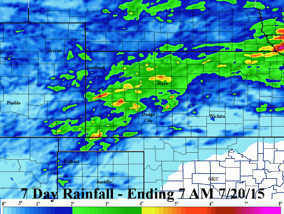
here) I showed a rainfall map of rain that had fallen in the previous 7 days, ending yesterday (July 1) morning.  I failed to display the color scale.  Ooops - here is the corrected map.


If you haven't followed along, in the last few posts I discussed the likelihood of a cool down and deteriorating winter wheat harvest weather.  Everything is falling into place, not only for the opportunities for almost daily/nightly rainfall, but for the impending cool down and increasing humidity. 

Looking at this mornings satellite image...


...the upper level ridge/high has shifted very slightly south since yesterday.  The system that had been over south central Canada yesterday had moved into eastern Nebraska.  An area of thunderstorms had already moved into much of Kansas and more is expected to develop and move across much of the remainder of the state.  Overall the pattern has become favorable for rounds of storms, some of which will bring heavy rain.  Some areas won't get a lot but a larger percentage of the area will be getting wet.

The Weather Prediction Center (WPC) has boosted up rainfall totals for the next 7 days (compared to yesterday).  Not every location that is covered by this outlook will actually get that much.  Some more, some less.  But, the trend is certainly there for a lot of rain over the next week.

With the pattern bringing the rains, cooler temperatures and higher humidities will also be in the offing.  Is this cool down and wetter pattern only temporary?  As I have discussed in the previous posts - no, it does not appear so.

In the post I did on the 25th of June (click here), I mentioned the Southern Oscillation Index (SOI) and I had noted that the index was "crashing" and that was usually an indication of an impending cooling trend.   I also discussed tropical activity across the western Pacific and that has now ramped up with several typhoon's.  This type of activity also supports cooler weather across the central U.S. a week or so after that occurs.

In addition, the Madden Julian Oscillation (MJO) has become VERY strong for this time of year and is predicted to remain very active and coherent as it moves east and then southeast over the next several weeks.   Typically I don't discuss the MJO during the summer as it is often a cool season phenomena that impacts the U.S.  But this one is anomalously strong and influencing!  The last post I discussed the MJO was on January 16, 2015 (click here if you want to read it).

Here is the latest MJO chart...

There are what is called phase spaces corresponding to intensity/magnitude and placement across the Pacific.  The black line represents where the center of the coherent MJO was and the colored lines are various ensemble predictions of where it might be at a later time and in what phase space.  The numbers (-3 to 3) represent the amplitude or strength compared to a standard deviation from "normal".  The prediction for 10 to 14 days from now by some computer models (not shown here) are off the scale!   Regardless, the model depicted above is nearing a standard deviation of almost 3.  This is unheard of for Summer!

A corresponding composite chart shows what can be expected (usually) with varying phases for this time year.  In other words, when an MJO occurs this time of year at a specific location (phase space), the corresponding weather that occurs across the U.S. is composited into an outlook.

 The MJO is historically pretty accurate.

So, putting it all together with the MJO, the tropical activity across the western Pacific and with the crashing SOI, then the outlook for much cooler and wetter across the high plains (and much of the central part of the county) seems on track.  In addition, the cycling pattern, that I have discussed before, is also entering the cool phase of the repeating pattern.  This takes us through the majority of July!

Very long range computer forecast outlooks certainly agree.  Remember, these models are run, in general, every 6 hours with updated inputs.  The solutions that they generate often change significantly from one run to the next.  However, the output recently has been consistently cool and wet.  For example, for Dodge City, look at what the latest shows...

For temperature....

The black line represents the ensemble (more than one solution) mean and the gray shading is the range of the forecasts.  This solution is also very similar across much of the corn belt too.  That might be bad if the growing degree days are lagging.  This is a pretty chilly (comparatively speaking for July) outlook!

For precipitation at Dodge City...WET!


Don't take these numbers literally as they change every time the program is run (and each ensemble is a little different), but the signal has been there for some time and it continues.

I think the screaming message here is....

1) Those that haven't got the wheat cut across Kansas will find fewer and fewer opportunities to do so.  This will also extend into northeast Colorado and Nebraska.

2) The corn "may" have issues?  With this cooler regime, the growing degree units (days) will fall behind normal, if they haven't already.  I guess that is alright unless we have an early freeze this fall.  Speaking of which....well it's too early to say for sure, but I'd would start leaning towards an early one. I'll have to discuss that possibility later this month.

3) Flooding.  Those areas that are hit repeatedly will have flooding.

NOTE

I won't have an opportunity to post again until the 10th at the earliest or 13th at the latest. Thanks for reading....

Wednesday, July 1, 2015

Quick update - 07/01/15

I have limited time but wanted to post a quick update.

Here is the latest rainfall map for the past 7 days ending early this morning.  The bulk of the heavy precip fell across parts of the corn belt.  (click for larger version if you want).


In the previous posts I discussed the change to wetter and cooler weather starting the first week of July.  It still appears that this will be the case.  Today (Wednesday) should be the hottest day of the period (although briefly we may see more heat Monday).  Go back and review those last few posts if you haven't already.

The Wednesday afternoon satellite image showed several features of interest.  The first is the upper level high (ridge) that was parked over the 4 corners. It is responsible, in part, to the heat in the plains (but especially to the Pacific Northwest).  This ridge is being beaten down by increasing flow aloft and upper level systems that are rounding the top and headed southeast.  The first feature over south central Canada (labeled #1 on the map below) will bring a decent front into the central plains Thursday and Friday.  It will bring cooler weather and pretty sizable area of rainfall.  The second feature (labeled #2 on the map below)  will bring a brief one day warmup either Sunday or Monday but once it turns southeast the cooling trend may start in earnest. It will also bring another round of precipitation.  In addition, there may be smaller areas of thunderstorms in between the systems, especially across eastern Colorado.


 The "real" cool down will likely be across the corn belt but it will extend into the plains.  I will discuss in greater detail this coolness, either tomorrow or next week.

In the meantime, here is the Weather Prediction Center's outlook for rainfall through July 7.