The weather pattern continues to change across the high plains - and not necessarily in favor of crop producers! It is VERY early in the stages of the "new" pattern that will persist into late summer of 2020. If you look for a winter outlook on the internet, you'll see everything! Keep in mind that many of the authors of those outlooks are non-meteorologists and are in high school (I know this for a fact)! The "official" NOAA outlook came out yesterday, and even those folks misrepresented or misunderstood their very only maps! Ugh!


What the maps indicate for the high plains is for the odds tilted in favor of above normal temperatures for the entire period of December 1st through February 29th (yes, a leap year). Only odds of this happening! Plus, it doesn't give any information of just how much above - even if it will be.
On Precipitation for the high plains the odds are tilted in favor of above normal precipitation across the northern portions of the high plains. For the remainder of the high plains there is NO tilt in favor of below or above! It really doesn't matter. The outlook is based almost entirely of a composite of ENSO (El Nino/La Nino/Neutral) neutral conditions. A composite! An average of years with similar Equatorial Pacific water temperatures! When is the weather around here ever average?
Other outlooks you may be seeing are based on who knows what. Some are probably done to get you to click on their graphic (click bait). Are any of them going to be right? Yeah, probably but by chance? Do the odds favor what NOAA put out? Yes, but ONLY based on ENSO conditions! So, if ENSO conditions end up being the driving force, then that might be a pretty good outlook. But, will ENSO be the driving force for this new weather pattern? I can't say at this point - there is NO evidence at this point.
What do I think will happen? Go back from the beginning of this blog. There is simply NO concrete evidence of what to expect this early in the fall. Remember, the new pattern just started. I could give you my gut feeling. I might in the next post or two.
Here is what I wrote in the last post I did on the 9th (you can read all of it by clicking here)...
************
Remember, early fall is a tricky time to make a long range outlook. Having said that, some of the signals across the western Pacific point to a possible increase in opportunities for more precipitation starting late next week. No computer models are indicating much of anything for the high plains through the 25th of this month. But, I will be highly surprised if we don't go into a period of increased thunderstorm activity and mild/warm temperatures by the 18th. The main issue I see is getting Gulf moisture back this far if there are frequent fronts. Having said that, the best opportunities will be east of the 100th meridian (not high plains but central and eastern plains).
************
So, I'm not going to say at this point because I'd likely have to change my thinking within a month of so anyway.
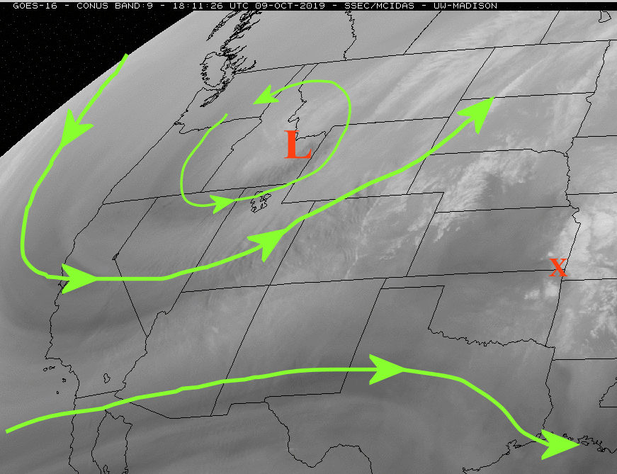
That last part of the paragraph above - No computer models are indicating much of anything for the high plains through the 25th of this month. But, I will be highly surprised if we don't go into a period of increased thunderstorm activity and mild/warm temperatures by the 18th. The main issue I see is getting Gulf moisture back this far if there are frequent fronts. Having said that, the best opportunities will be east of the 100th meridian (not high plains but central and eastern plains). That is actually working out just about right. There will be a system (cold front and then upper level system) coming through this evening that should produce scattered thunderstorms. The issue, as I suspected, is a lack of good gulf moisture. One reason? The development, in the Gulf of Mexico, of a tropical storm "robbing" good inflow of moisture into the central U.S.. I hope a system in the Gulf doesn't repeat too many times this winter. Here was the latest satellite....

The front will be associated with the upper system (red X) moving out of the Rockies. Even with the lack of good Gulf moisture, a few will get some good rains across Kansas but the majority will not.
Beyond this current system the forecast will be very tricky. Looking at the western Pacific Ocean area....

The weather is actually very active which could impact the high plains later next week and into the weekend - and perhaps into the first few days of November. First there were three tropical systems tracking west and northwest towards Asia. The contribution to the Jetstream that is and will occur, will have downstream amplification that could (I really should say "will") cause amplification across the central Rockies around mid-week next week. There should be a pretty cold airmass that sweep across the high plains centered on Thursday (may be Wednesday, may hold off until Friday) that will bring below freezing temperatures again. Depending on just where this amplification occurs, there will be a large range of possibilities for the high plains from nothing but dry, cold, and windy to colder with rain and snow. Start checking local forecasts early next week for those possibilities.
Another important feature on the satellite above is the MJO across the Indian Ocean. It is not robust but it was impacting the jetstream at higher latitudes. Most computer models have this system dying out before it gets too far east. That is questionable but a distinct possibility. The eventual evolution will have HUGE implications on the weather in early/mid November. Stay tuned for later posts about that because I see an opportunity for MUCH below normal temperatures and precipitation during that time frame - albeit with very low confidence at this point. If that MJO continues, confidence increases.
Finally, here is the 7 day precipitation outlook from the Weather Prediction Center...

The precipitation in Kansas that is on the map is solely from the activity tonight (Friday night) and into Saturday.
I'll try and post again toward the end of next week.