Saturday, November 18, 2023

There are a lot of conflicting signals!

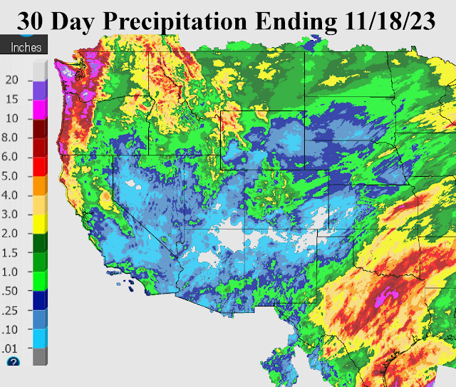
The weather pattern has been flipping between a La Nina response like upper flow and then showing signs recently of a "typical" El Nino weather pattern with rain and snow into California and wetness across southern Texas.  Here is the precipitation accumulation for the past month ending the morning of November 18 (and notice the tremendous precipitation accumulation across the northwest U.S., atypical of an El Nino pattern...


If you look at indices of ENSO, then one could argue that a true El Nino (at least a strong one as we have been led to believe) is not in place, at least yet.  Sure the equatorial waters of the Pacific support an ongoing El Nino by looking at the Oceanic NiƱo Index (ONI) three month average where the warmest waters have been in the Nino 1+2 region.  But the Multivariate ENSO Index (MEI) and the Southern Oscillation Index (SOI) do not support a true El Nino.  One issue has been the warmer than average waters across the mid and high latitudes of the Pacific.  The atmosphere has responded at times with storms slamming into the Pacific Northwest and across the northern Rockies and northern Plains.  Recently California has joined in the action (more of an equatorial Pacific contribution).  Where does that leave us in the plains for the rest of the fall and through the winter?  Will the plains benefit from a transition to a more typical El Nino pattern, or will it be back to the drought for those that got the good rains this summer?  

For subscribers to Hutton Weather Futures weekly weather outlook reports, those questions will be answered.  Although there have been discouraging signs with this weather pattern, I'm seeing some promise buried in the data!  But a lot will have to come together before I know for certain that improvement will be made in terms of soil moisture across a large chunk of the region.  

To subscribe for weekly reports, go to https://huttonweatherfutures.com for more information.

Sunday, September 24, 2023

Changing of the guard - the pattern is changing

For much of 2023 growing season, rainfall was extreme across parts of the high plains with late spring and summer rains. In terms of percent of normal, some locations saw 2 to 3 times what is "normal".   At the same time the eastern part of the plains had limited (seasonal averages) rainfall with increasing drought conditions.   Now that the jetstream across the northern hemisphere is increasing in strength, the weather pattern is in the process of "reforming" into what is hopefully a favorable one for crop producers.  A clear picture won't be known for several months but clues will start to emerge soon.  

Even though rainfall this past few weeks has been minimal for much of the high plains, late August and early September storms brought some decent moisture (except for some up in northwest Kansas).  A map of rainfall this past 30 days ending 9/24 illustrates the beneficial amounts for many locations....


The recent (9/21-23) storms across mainly Nebraska, far eastern Kansas and eastern Oklahoma (and points east) is part of the earlier weather pattern (shifted climatologically east) and perhaps a glimpse into what is starting to develop.  I want to start seeing weather systems deepen into the central and southern Rockies to be encouraged.  Some of the long-range computer forecast models have been hinting at decent moisture for October. I'm not "sold" just yet.  

For the subscribers to my weekly weather outlook reports at Hutton Weather Futures, I will be carefully analyzing the new developing weather pattern and will be looking for "clues" of what may impact the Great Plains later this fall, winter and going through the next growing season. Take advantage of the September special pricing for these outlook reports.  You will get these weekly reports for October and November (2 months for the normal price of 1 month).  You can subscribe using this link  https://pay.huttonweatherfutures.com/September_special  or go to https://huttonweatherfutures.com.


Thursday, August 10, 2023

September is the transition month - what can we expect going into fall?

For many in the Great Plains, July was near normal to above normal, and in some cases, exceedingly wet.  Yet, there was quite a large area (comparatively speaking) that did not benefit from the continued active weather pattern.  Here is a look at the rainfall percent of normal for July....


This was a shift in the pattern from what had been a wet northeast Colorado, northwest Kansas and western Nebraska.  However, so far in August this wet area has shifted back north.  Now the question is will that continue as we transition into fall? 

One good thing about the wetness across what had been the hardest hit area of the drought is that temperatures were highly mitigated due to the wet ground and lush vegetation, 

The upper air map is illustrating an unusual southern shift in a relatively strong jet stream (compared to normal for August).  Here is the map from this Thursday morning...


The shift can be tied to many things going on across the northern Hemisphere (namely areas of forcing and those teleconnections).  This might be a clue going into the fall months and into winter/spring in what we can expect as the new weather pattern (2023/2024) begins to organize.   This is and will be discussed at length in outlook reports that are sent to clients of Hutton Weather Futures.  Consider joining those already subscribed that are informed to make business decisions from accurate long-range forecasts!  Visit my website Hutton Weather Futures for additional information on how to subscribe.

Thursday, June 29, 2023

Wet July?

This crazy weather that went from a significant drought to significant wetness (for many) looks to continue off and on this summer.  The upper-level flow this past 60 days has been unusual at times.  For a while back in May winds aloft were anomalously week for the time of year and actually contributed to westward moving convection and can be attributed to some of the monstrous rainfall totals this past 45 days.  There are rainfall observations of 15 to 20 inches since May 1 and I can find quite a few of those reports in the Texas Panhandle, east central Colorado, western Kansas, and southwest Nebraska.  Of course, as is typical with convection, adjacent locations missed out on some of those bigger rains.  There are locations that have had 5 to 6 times normal rainfall!  Look at the map of percent of normal rainfall in the 60-day period ending 06/25!!


Of course, we should not expect these types of anomalies for the remainder of the summer.  It's not a zero percent chance of that happening, but the atmosphere will likely not allow it.  The upper air map from this morning shows a continued active pattern despite being late June. 


The winds aloft are certainly weaker than they would be earlier in the year, but still strong enough to support occasional complexes of storms, similar to what moved across Nebraska and northern Kansas overnight (6/28).  As long as the upper high across southwest Canada continues to dominate at that location, and the upper air high (currently over Arkansas and Louisiana) doesn't expand into the central part of the country and park there, then I believe there will be continued opportunities for more rain in July.  I don't see much chance of a repeat of July 2022 when the spigot was shut off.

In the reports I send out through a subscription to Hutton Weather Futures, I have detailed and highlighted those periods/days of increased odds of rainfall for July and August.  Conversely, decreased odds of any rainfall have been noted.  Ideas of when the first fall freeze are shaping up and I've come up with odds on that.  Won't you consider joining the growing number of folks that have been reaping the benefits of accurate long-range forecasting!   Visit my website for additional details on how to sign up.

Wednesday, May 10, 2023

May is all over the place!

This past month has seen varying amounts of rainfall (and snow in some areas) which is certainly typical for the Great Plains.  However, the same areas that have been hardest hit from the drought seem to be missing out on many of the opportunities, but yet there was one widespread rainfall event the last week of April that blessed a large part of southwest Kansas.  Look at precipitation this past month....


The colder than normal conditions and precipitation had been expected as I laid out months in advance. Based on the pattern that set up in the fall and timing the harmonics of the wavelength of the pattern, I have identified the most likely periods of opportunity for rainfall going into June.  Of course, it doesn't mean that it will rain everywhere on a given day or period, it is just the time of increased opportunity that the atmosphere may respond with more rainfall.  A sample graph for June is below.  For folks that have subscribed to my outlook reports I will advance this into July and August as well and include periods of when I expect the most heat to be.


Consider joining this premium service that could help you in planning of your operation in the crop and livestock world.  Try it out for a month for $100 and see what you think!


Go to:  https://huttonweatherfutures.com/ to learn more about that opportunity for a premium service.

Thursday, April 6, 2023

Same pattern, same result

The active pattern continues but has produced about identical conditions across the Plains and into the midwest and Mississippi Valley.  The wind and dirt have been brutal, but expected.  The blizzards and heavy snow across the northern parts of the western Corn Belt have been significant.  The severe weather including tornadoes across the midwest and Mississippi Valley have been expected based on my reports I have been providing.  Here is the precipitation totals that have occurred this past 30 days ending today April 6....


Prospects for changes for April are not great.  There are subtle hints of better things to come but it could be a while yet.   In my reports to my customers of Hutton Weather Futures I have addressed these opportunities.  

Consider joining this premium service that could help you in planning of your operation in the crop and livestock world.  Try it out for a month for $100 and see what you think!

Go to:  https://huttonweatherfutures.com/ to learn more about that opportunity for a premium service.

Friday, March 17, 2023

More wind - little precipitation - better days ahead

This past weather system that rolled through yesterday, March 16, packed a punch in terms of crashing temperatures and high wind.  At least a little precipitation was generated. 

Here is a map showing what fell during the 3 day period of March 14-16...


In the report I sent to the subscribers to my longrange outlooks, the next period that "could" bring some precipitation is coming up next week.  It likely won't be just one system, but a series of weaker storm systems.  After that there should be a couple more opportunities going into April.   In the report I sent out to those subscribers and in subsequent reports I'll be sending, more dates of opportunity have been identified.  Please consider joining this premium service that could help you in planning of your operation in the crop and livestock world. 

Go to:  https://huttonweatherfutures.com/ to learn more about that opportunity for a premium service.

Thursday, February 23, 2023

Update 02/23/23

As a reminder I will only be updating this blog site on occasion as I move forward with my consulting company, Hutton Weather Futures LLC.  I will provide more detail in outlooks emailed to subscribers and the reports will of course be much more frequent as a subscription service.  That web address is https://huttonweatherfutures.com/  

As I have mentioned in the reports I have been emailing to my customers, weather systems in this current pattern are on schedule.  The next system that I have targeted is for late this weekend.  It will likely be the first severe weather "outbreak" for the central part of the country.  Rainfall on the west end will be limited once again but may be farther west this time.

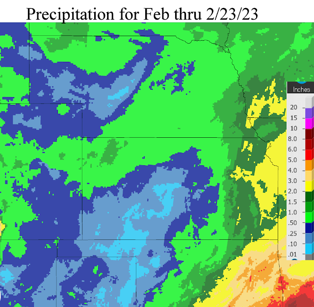
So far for February, the results from the active pattern have been nearly the same (eastern areas benefiting greatly).  Here is a map of precipitation that has fallen this month (February)....


Other systems are due periodically in March with one in particular expected around the spring equinox. 

Hopefully you will consider subscribing to my consulting update reports as I'm certain I can provide useful information (inputs) into making your crop and livestock production profitable.  

Wednesday, February 1, 2023

Weather Systems are on schedule?

 First - if you haven't been visiting this blog site lately, please review the one I did on January 20 (click here) to read up on how this blog will be handled going forward.  With my consulting company, Hutton Weather Futures LLC, I will provide more detail in outlooks emailed to subscribers and the reports will of course be much more frequent as a subscription service.  That web address is https://huttonweatherfutures.com/.  I will only occasionally update this blog site "swkswx.blogspot.com". 

As I have mentioned in the reports I have been emailing to my customers, weather systems in this current pattern are on schedule.  The next system that I have targeted for February 7-8 has been showing up in some of the long-range computer forecast models but with inconsistent timing and inconsistent features.  Confidence is fairly high that there will be impacts across parts of the Great Plains.  Details at this point are uncertain.

Looking at the current upper air map, any potential storm for next week is not really showing up on this map at least as of Wednesday evening (1st)....


The storm moving across northern Mexico has been weakening but still very capable of producing a widespread precipitation event from southwest Texas and eventually into the lower Mississippi Valley.  It is way too far south to impact the central plains.   The strong system across the eastern Pacific (the big red L) will be moving northeast into Canada and will only promote warming for the central plains but with no indication of any moisture.

Any potential storm next week hopefully will benefit the area that has been consistently getting missed as you can see in the precipitation maps for January (the first is the amount and 2nd is the precent of normal).


For January that is a hefty amount of precipitation for Nebraska and northwest Kansas!

Again, I have started the subscription service at https://huttonweatherfutures.com.  I hope you will consider subscribing and join the others receiving these frequent updates of the expected weather as we get into the growing season.

Friday, January 20, 2023

Subscription Services have begun - 2nd and 3rd storms

If you read the previous blog posting on the 27th (read it by clicking here) then you are aware that I retired from my position with the National Weather Service at the end of 2022.  I have since formed my weather consulting company - Hutton Weather Futures, LLC and will be providing a more specific form of weather outlooks that are similar to what you may have read in this blog.  It is a subscription-based opportunity for you to receive valuable insight into what can be expected weather-wise far into extended periods to help in your business needs.  Access to the data is through a weekly (or as needed in between a weekly report) that will be emailed to you.  The pricing structure is stated on my company's website, and that is:

https://huttonweatherfutures.com/

I hope you will consider the opportunity to receive these reports that will be delivered on a consistent basis (with occasional updates).  I will likely "occasionally" post here on this blog site but without as much detail as I hope to provide with the subscription-based service. 

In that previous blog posting on the 27th, I had mentioned three potential systems that could benefit much of the western high plains.  It was unclear on the track of number 2 and 3.  The first system behaved as expected with the biggest impacts being across northeast Colorado and far northwest Kansas and into Nebraska.  Amounts for much of southwest Kansas were very light in most areas, but anything helps settling the dust, I guess.


System number 2 that is expected this Friday evening and into Saturday will be rather compact, but the eventual track will benefit much of the area that was missed by system number 1.  I would not be surprised to see six-inch snow amounts at some locations across western Kansas but especially into southeast Colorado. Unfortunately, there will be a sharp gradient on the south side of the snow area and those south of the gradient will not get much, if at all.  The location of the snow shield will not be known until the event starts.  Moisture content in the snow will be on the wetter side!

System number 3 will impact the region late Sunday into Monday.  The eventual track could be making it an Oklahoma storm, but that track is highly suspect.

Again, please visit my website for details on a subscription-based service...

https://huttonweatherfutures.com/


Tuesday, January 17, 2023

Three storms and who will benefit - plus I'm transitioning to Hutton Weather Futures LLC

As many of you are aware, I retired from my position with the National Weather Service at the end of 2022.  However, I'm not leaving weather as a profession.  I have since formed my consulting company - Hutton Weather Futures, LLC.  I will be providing a more specific form of weather outlooks that are similar to what you may have read in this blog.  It's in the formative stages at this point but will be gaining ground quickly.  It will be a subscription based opportunity for you to receive valuable insight into what can be expected weather-wise far into extended periods to help in your business needs.  At this point, access to the data will likely be a through a weekly or sub-weekly report (or as needed in between a weekly report).  The pricing structure is still be worked on. I hope to have everything ironed out by the end of this week (20th) and details will be shared in this blog.  Stay tuned by checking back. 

In the past week I've spoken at several meetings discussing this awful weather situation that much of the high plains has been in.  The one silver lining is that there have been weather systems, but unfortunately they have not benefited much of the high plains.  Starting tonight and through middle part of next week, there will likely be 3 more opportunities.   Looking at the upper air map from this morning...


A very strong upper level storm was moving towards the Four Corners region.  It has been strong enough to dump copious amounts of snow even as far south as Flagstaff Arizona.  The issue (as is typical) will be the eventual track of the storm as it moves out into the plains.  Unfortunately for much of the high plains of Kansas down into west Texas, the system will track too far north to bring significant moisture.  Northeast Colorado, Northwest Kansas across much of Nebraska there will be a large area of heavy snow.  Across the eastern half of Kansas there will be pretty fair amount of rain and even freezing rain closer to the Nebraska/Kansas border.

A second potential storm, that as of this morning was across the Gulf of Alaska, could impact the plains.  It was set to amplify into the high plains over the coming weekend.  Initial thoughts would have it tracking a farther south so that areas that miss out tonight/Wednesday should get at least some precipitation (likely in the form of snow).  Details are not possible at this point as the system will have to undergo strengthening and amplifying before any idea will come into light.  But, fingers crossed!

A third system is simply a small disturbance aloft that was currently way out in the Pacific.  It is denoted by the red X on the top left corner of the map above.  There is some possibility that it could be a system to watch by the middle part of next week.  There is a tremendous amount of uncertainty.

Here is the early look at what could fall through next Tuesday (image from the Weather Prediction Center)


An important point though is that all three of the systems may miss much of the high plains of Kansas into the southern high plains.  As stated above, there have been systems all fall and winter but most have bypassed the hardest hit region of the drought.

Speaking of which, here is the latest drought map.


California has certainly improved in that category!  Here is a percent of normal precipitation since the beginning of January.  


Some of the snowpack stations are already above the seasonal normal and some are approaching record amounts of moisture in the snow -  already!  If only we could get just a taste of that.

So to recap...

I've started a company - Hutton Weather Futures, LLC.  Frequent (at a minimum weekly, but with updates) reports will be emailed to subscribers.  The pricing structure has not been set but hopefully I will be ready to go by the end of the week.  Details are forthcoming and will be posted in this blog.  BTW, this blog will probably continue but on an in-frequent basis with less detail.