Friday, July 28, 2017

Short Update - 07/28/17

This will have to be relatively brief again.  The North American Monsoon that got going about 3 weeks ago has been very robust across the western U.S. and the Rockies and has benefited the central U.S. at times with periodic cooler temperatures and precipitation.  One of the disturbances that was generated from the pattern impacted the Kansas City area a few days ago producing record flash flooding.  Looking at the central U.S., there are areas that received very substantial rains while other areas not too far away have in general missed out.  Those lucky ones that planted dry land corn and have also got the timely rains could use another drink and it looks like they just might be in luck.  The very hot temperatures have only lasted 3 to 4 days before brief cool downs occurred, as was expected.

First, the next two images shows the precipitation that has been observed the past 2 weeks, along with the departure from normal.  Obviously it has really dried out across a lot of the area, but there is also those areas that continue to be wet.


Looking at the satellite image, there is a relatively strong disturbance (the red X across Nevada) that is going to ride across the big upper high that was in place across Oklahoma.  This should help to enhance the overall coverage of showers and thunderstorms, especially Saturday night and Sunday.  The pattern will continue to waffle back and forth going into at least the first week of August.  This means that there will be a periodic chance for additional rains.  At this point, I'm not seeing much indication of the really hot air anytime soon.  In fact temperatures in general will be below average for at least a week.


Here is the expected precipitation during the next 7 days.


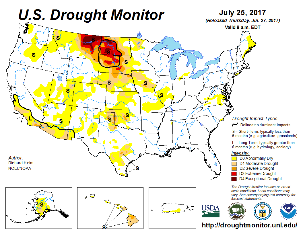
As far as the drought, much of the dry area across the panhandles may be wiped out during this wet period coming up.  Farther north, not much luck for the  drought hammered northern plains.  Even for Iowa things are looking a little bleak at the moment.


I'll see if I can write up something again by the end of next week.

Cheers.

Wednesday, July 12, 2017

Typical Summer weather - Updated 07/12/17

The current pattern is rather typical for this time of year.  The North American Monsoon has been established, for now, and cranking up pretty good!  Historically it usually will benefit at least some of the high plains.  That has already occurred with scattered thunderstorms across eastern Colorado and northwest Kansas on Tuesday.  As the upper high meanders from the Rockies to the Mississippi Valley, temperatures will be up and down.  The hottest will likely be as the high is overhead and cloud cover is at a minimum.  Here is the latest satellite image from this morning....(click for a larger image)


 During the next 10 days or so, very little will change in the overall scheme of things.  The issue for the corn across the central part of the country will be the hotter temperatures (over 100) occurring at the wrong time (for pollination).  At least I don't see an extended period of 7 to 10 days of 100+, meaning there should be brief breaks.

Here is the Weather Prediction Center's outlook on precipitation through  next Wednesday to 19th...


Unfortunately for much of the Dakota's where the drought is expanding, the outlook for a lot of rain up there is very small.  Here is the latest US drought monitor...


As far as what has fallen during the past 2 weeks...first for much of the corn belt....


And for the high plains....


I'll be a county fairs next week so won't have a chance for an update until probably the 24th.