The changing weather pattern continues to get settled into place as of early November. Longtime readers of this blog have heard this before - the "new" weather pattern across the northern hemisphere begins to take shape during the transition from summer into fall as the flow aloft intensifies. Areas of forcing, or contribution to the pattern, are unknown. This forcing might be transfer of latent heat from oceans (tropical to higher latitude), mountain ranges, landmass interactions, and even external forces (energy from the sun), etc. So, this years pattern is really in its infancy and I could only guess what is forcing the flow aloft. Once the flow aloft gets settled, it will transition into cycles of troughs and ridges that tend to get anchored at locations across the hemisphere.
Back on October 18th in that posting (PLEASE take a look at that one by clicking
here) I said right off the bat
"The weather pattern continues to change across the high plains - and not necessarily in favor of crop producers!" I haven't changed that thinking - but that thought was based more on a gut feeling as the new weather pattern was VERY young.
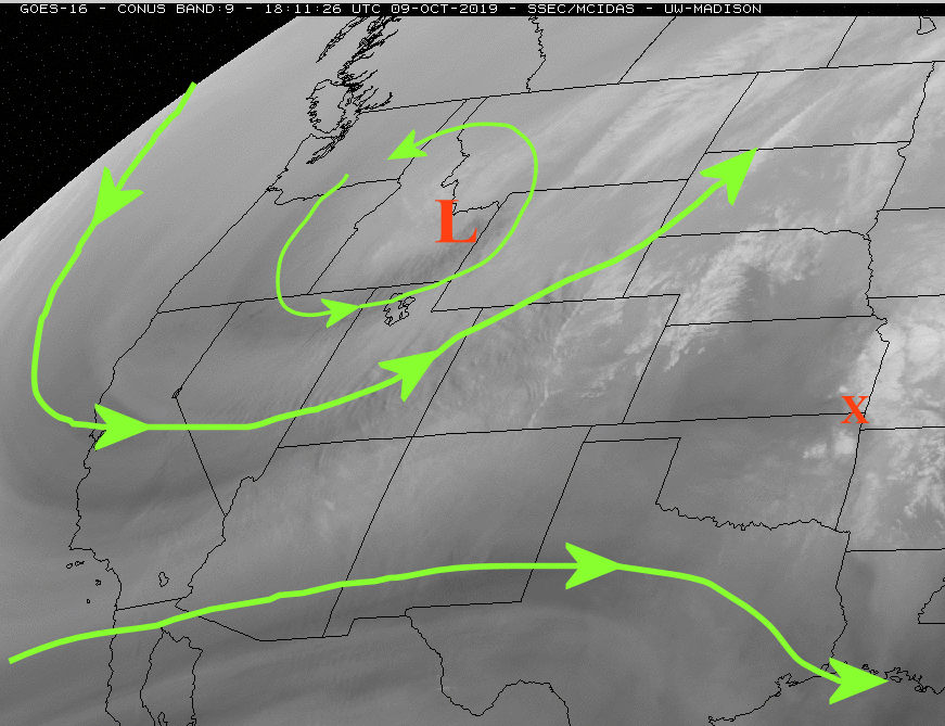
Looking at this mornings satellite image....
There is/was a lot going on across the Pacific. One system will be riding up into southwest Canada and then will drop southeast across the plains by Monday. This will unleash yet ANOTHER very cold airmass! But this cold air will only last a couple of days for the high plains. Farther east and northeast it will persist for a while. This will be one of many strong cold intrusions that we've had so far. That is one clue for this winter and going into the growing season. That is, cold fronts may be numerous this winter which would translate to periods of very cold days/nights. But, because of the flow aloft configuration, the cold will likely be moderated by rapid warm-ups, especially for the high plains. Title this Winter outlook = very changeable Averaging out the very cold to rapid warm-ups should yield temperatures near normal for the winter.
Caution: The pattern is still forming. Is there a chance that the pattern gets "locked into place" at some point? Yes. What would that mean? If it locks into the pattern when intrusions of cold are prevalent then expect below normal temperatures as an average for the winter. Conversely, if the pattern locks into place during the warm phase then it would be warmer than normal. Honestly, I need another 3 weeks (give or take) to get a better feeling as the pattern starts to settle down. I would lean at this point to averaging out to colder than normal.
As far as precipitation - these numerous intrusions of cold and the way the jetstream configuration has been does not bode well for precipitation. Based on what has happened so far, I would lean towards the dry side. But, again the pattern has not fully developed so there is still a bit of hope. There could be a system producing something across the high plains by next weekend (the 16th or 17th). That depends on the evolution of the jetstream across the Pacific.
I'll end this post with something pretty interesting, as far as history of weather is concerned.
At Dodge City, this past October was the 6th coldest on record. At this point, it appears that November "may" end up colder than normal. Looking at the record books, the top ten cold Octobers followed by a colder than average November....1911 was one of those years. There was also very similar Pacific Ocean temperatures in 1911 compared to the current situation. In 1911, the sun spot cycle was somewhat similar (minimum period like now). And even September 1911 was very hot, like this year. Hmmmm.
Oct 1911 -3.0 degrees, 3.2 inches of snow
Nov 1911 -5.1 degrees, 5.1 inches of snow
Dec 1911 -4.9 degrees, 15.4 inches of snow
Jan 1912 -14.2 degrees, 2.9 inches of snow
Feb 1912 -3.9 degrees, 19.7 inches of snow
Mar 1912 -13.9 degrees, 11.2 inches of snow
Apr 1912 -1.1 degrees, trace of snow
May 1912 Frost on the 16th
BRUTAL!
Can that repeat? Yes to an extent. Will it? Highly doubt it but it makes one wonder with the similarities. The current pattern we're experiencing would NOT support that. But again, it hasn't settled into that specific regime yet.
I'll try and update by the 15th.