Friday, August 28, 2015

The pattern is slowly changing? Update August 28, 2015

In the previous post I did on the 24th (click here) I discussed the tropics and how they had become very active (both Atlantic and Pacific basins).    Much remains the same today, if not even more active AND complicated!

As I stated in that previous post, latent heat processes from the tropics into the higher latitudes is what drives much of our weather.  When these releases "ramp up" as they are doing now it can cause chaotic flow at the jet stream level and thus cause headaches in forecasting.

I'm starting to see some subtle signs that the long term weather pattern, which got established last fall, is beginning to change/fall apart.  I can already see that with precipitation and thunderstorm behavior that has occurred recently.

Take, for instance, what happened late yesterday and last night across Kansas.  For much of the summer, the weather pattern across the plains would have been favorable for widespread thunderstorms (and copious amounts of rainfall).  What happened instead yesterday was no rain for some, and a lot of rain for others across a short spatial distance.

In the map that follows (click for a larger version), you can see the huge differences in rainfall in and around Dodge City.  For instance, I only observed 0.07" while just 5 miles away there was 1.5"!


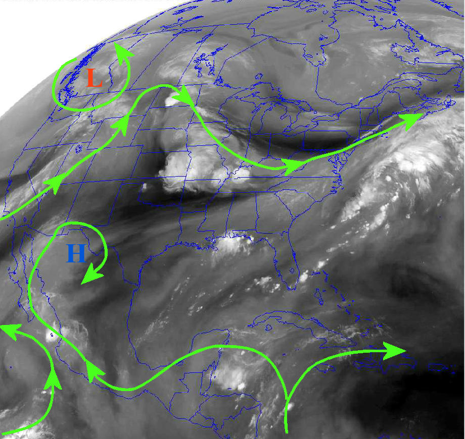
Back to the tropics.  In the following hemispheric satellite image, I've highlighted the jet stream, upper lows (troughs) and 8 tropical systems (disturbances, tropical storms and hurricanes).


You might have heard of Tropical Storm Erika.  I have it labeled as number 6.  Even though the ocean water temperatures are very warm and very favorable for intensification, the upper level winds are such that it may never make hurricane status.  We'll see.  At a minimum it will bring heavy rains to Florida. Then there is Hurricane Jimena (number 3) in the eastern Pacific.  This hurricane is expected to become a major one as it tracks precociously close to Hawaii, likely passing by to the north.

All eight of these systems labeled (as well as other clusters of tropical thunderstorms) are releasing latent heat that is transferring to higher latitudes.  This process, in part, is responsible for the crazy configuration in the jet stream (the green wiggles).  The red "L" with the arrow pointing towards it will likely become an established trough across the western U.S. and may persist until at least September 5th, if not later.  What this means for the high plains is above average temperatures, moderate daytime winds and little to no chance for widespread rainfall through that period.  The only hope is that a weak tropical disturbance is caught in the flow and transported northward towards the center of the country.

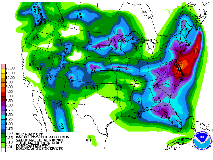
The Weather Prediction Center has the following outlook for rainfall through September 4th.

Ought oh, is there an early fall freeze in the offing?

If there is going to be an early freeze this fall, it WON'T BE because of what has happened this summer.  Rather, it will be the result of a new developing weather pattern.  The only thing I have to go on right now is what some of the long range computer models are suggesting.  For the past week or so the output from these computer models have suggested that an early freeze is possible.  Keep in mind that each time the model is run (every six hours with new data), the resulting outlook and specifics are different.

But, just going strictly on what the contributions from tropical activity have been and is likely to continue during the next month, I'm beginning to lean towards and earlier than normal freeze.

The following map shows the average date of the first 32 degree reading of the fall: 


And a map of the average date of the first 28 degree reading:


The following graph is the output from just one of the long range computer models for Dodge City.  It shows nicely several strong cold intrusions (1 through 4) with the latest one being the coldest.  It looks reasonable but don't take the numbers literally.


For the latitude band of Nebraska and Iowa, take about another 10 degrees off.

BTW, the same computer model has been very consistent with predicting a "wet" fall, which actually looks very realistic.  More on the precipitaton outlook next week.


Monday, August 24, 2015

Update - August 24, 2015 (Can Winter be far away?)

Over the weekend you may have heard about the snow that fell in and around Calgary, Alberta Canada.  Even for that area this is extremely unusual for this time of the year!  The snow was the result of an anomalously COLD airmass that swept across Canada and into the United States.  The cold was felt well south into the plains with several stations reporting record cold low temperatures!


Does this event foretell what is to come this fall and winter?  In short, NO!  This is still related to the pattern than has been in existence since last fall.  The pattern will finally fall apart and a new one will emerge during the next 4 to 6 weeks.  Take any outlook you are seeing right now with a grain of salt.  All of them are mostly made using a composite of El Nino winters, which vary from one to another.  A composite of what has happened in the past is NOT a great indicator of what is upcoming although odds tilt in that direction.

This satellite image from this Monday afternoon depicted the upper portion of the cold airmass, just north of the Great Lakes. 


This pattern has also surpressed the North American Monsoon moisture well south and has scoured out the deep tropical moisture at the surface that had been in place across much of the plains.   The cold has also added to a growing deficit of growing degree days across the corn belt.  I'm still not sure if this is a big deal or not.   The latest map showing the departure from normal follows: (click for a larger map)

The cold front associated with the cold airmass did bring quite a bit of rain to parts of Nebraska and Kansas, although the high plains basically missed out.  Regardless, the long term drought is non-existent across the high plains, according the latest U.S. drought monitor.

 During the next week to 10 days the forecast is very tricky.  The primary reason is that the tropics (both Pacific and Atlantic) are becoming very, very active.  Latent heat release process from the tropics into the mid and upper latitude areas will have an impact.  The problem is there are a lot of unknowns about that extent of these impacts.   Hopefully I'll have an idea by the end of the week.

Here is the latest North America satellite image showing the various tropical systems.  Eight storms or disturbances is a lot!


The Weather Prediciton Center offers the following outlook for precipitation during the next 7 days.  


Wednesday, August 19, 2015

Update - August 19, 2015

Yet another active period just passed this past week across a large part of the high plains.  I traveled to Lubbock this past weekend and was amazed at the water standing, the lushness of the pastures and the stark contrast from just a few years ago. 

The weather pattern that set up last fall has continued into this late summer, but of course with seasonal variations.  How long will this continue?  Typically the pattern starts to decay as we go into late August and September.   It is amazing what happened about 43 days ago.  At that time there were two powerful typhoons in the western Pacific. Today, almost exactly the same occurrence! 


With the active Pacific, cold fronts have been a little more common this summer.  The front that moved through much of the plains on Tuesday (18th) has brought a rather chilly airmass.  Low temperatures this morning were much below normal and highs will struggle to warm much on this Wednesday.  Yet another front is expected over the weekend.

Over the past week, copious amounts of rain fell at a lot of locations! (click for a larger version).


As has been typical of this year, rainfall has varied tremendously from location to another, over a very short distance!  For the year so far it really hasn't averaged out.  Yearly rainfall from one location to the next has also been quite variable.  The following map is for precipitation for the year ending on the 18th of August.


By the way, some observing locations are approaching a record amount of yearly precipitation, all ready!
 
Looking ahead...

This mornings satellite showed an anomalously strong upper level system and also anomalously far south.  This is one reason why the strong cold front (summer standards) has moved so far south.   One thing you might note is the lack of the North American Monsoon moisture which typically extends well into the Rockies.  It has temporarily shifted way south into Mexico.


The flow across the midwest will dominate for another day or so.  Then high pressure aloft will begin to amplify but as it does it will force another front into the central plains later in the weekend.  This should bring another round of rainfall, but this time perhaps farther east.  Thus, the heavier rain with that may be across the EASTERN Lower Plains.

Beyond this weekend the upper pattern is uncertain, primarily because of the tropical activity across the Pacific.  I have a hunch that later next week will warm up significantly again but there may also be more chances for thunderstorms.  But, there is also a possibility that the pattern weakens enough so that the weather gets quiet, but warm.  More later...

Wednesday, August 12, 2015

Update - August 12, 2015

In the post I did on the 5th (click here) I discussed the outlook for the upcoming days being difficult due to a decreasing magnitude of the jet stream and flow aloft.  I also posted the expected 7 day rainfall map from the Weather Prediction Center and suggested that heavier amounts could be farther south.

Here is the 7 day cumulative amounts ending yesterday (11th).  Click for a larger version.


The thing that stands out to me is the exceptionally varying amounts of rainfall that fell during the period.  First, the northern Texas Panhandle and Oklahoma panhandles remain very wet!  Then there are those "isolated" pockets of excessive rainfall across southwest Kansas and eastern Colorado.  Then finally the exceptionally high amounts of rainfall that fell from southwest Nebraska, southeast into central Kansas.    So, some benefited greatly, some missed out and some had way too much rain.

As far as temperatures, there was one very hot day across Kansas, but otherwise temperatures were at least seasonal to below normal.  The growing degree days across the corn belt made positive gains but units are still running below normal for the season.


Looking at the satellite from this Wednesday afternoon...


The upper level ridge of high pressure that has periodically made an appearance this summer, is building again stretching from west Texas into the northern Rockies.  This pattern will shut off rainfall from the midwest into Kansas for at least 3-4 days.  The exception is that a small area of thunderstorms may form during the night time hours across western or central Kansas - similar to what happened early this Wednesday morning.  If this does repeat, it could be both Wednesday night and Thursday night, but is not too likely to happen.

The focus for additional thunderstorms for the high plains (better chances) will occur late in the weekend or first of next week.  See that "L" off the northern California coast?  That will lift north and then east and will usher in a front at that time.  Beyond early next week, any heat should be mitigated with only normal to even below normal temperatures expected.  Additional thunderstorms are possible next week.

Thursday, August 6, 2015

Update - August 5, 2015

We're well into the time of year that forecasting precipitation is extremely difficult since there are a  number of factors that can help and deter thunderstorm development.  Since there are so many mesoscale processes in existence and the fact that just a degree of warming at around 10,000 feet can prevent storms from forming, it is sometimes nearly impossible to accurately predict weather.

Take for instance what happened in July.  I had forecast normal to above normal rainfall for the month for much of the plains.  Indeed some areas were extremely wet, but at the same time there locations even in the same county that did not fare so well.  Look at the map below of rainfall for July.  (click for a larger version)


Look at the amounts just south of Elkhart.  That is between 12 and 14 inches, just for July!  Incredible!  But, then go just 30 miles straight east and only 2 to 3 inches fell.  Predicting that type of occurrence on a spatial scale is impossible.  Roughly 90 percent of the area did have above normal rainfall, but a small percentage was close to normal or below. Who would have predicted 18 inches of rain south of Tulsa?  And then go west about 50 miles from there and there was only 2 to 3 inches.   That's ridiculous!

Anyway, this rainfall that fell in the panhandles for July has continued into August.  Look at the rainfall up until the 4th across the panhandles.  That is more than a months average already at some locations! 


The wet July and rainfall so far this month has had a direct impact on temperatures and humidity.  This afternoon Elkhart and Liberal had a temperature of around 90 and a dew point (measure of moisture in the air) of 72!  This type of occurrence for an afternoon condition in August is exceptional!

Those that tried dryland corn this growing season across the high plains may or may not have benefited from the summer weather so far. I know a few that 1) had adequate sub-soil moisture from awesome farming practices; 2) have had perfectly timed rains; and 3) have had a surplus rains (above normal). They will benefit financially.  But I know of some others (a couple in Stafford county for instance) that have been begging and praying for more rain.  Looking at the map of July rainfall...yep, they somehow have been missing the storms.  Unlucky?  But I guess if you could afford the risk, this would have been the year.

So now what?

The river of air above us (jet stream) is reaching it's weakest point as we get deeper into summer.  It's hard to track systems across the central U.S. and now warming temperatures aloft may impact thunderstorm development. Here is the satellite showing several features:


The upper high pressure ridge centered over northern Mexico will expand rapidly to the north during the next several days.  In essence it will force a lot of the thunderstorm activity well to the north.  

But, at the same time, there was a relatively strong upper system across western Canada that will slide southeast and it's associated front will approach the central plains.  I think several things may happen.  There should be additional thunderstorms complexes that will dump lots of rain on Nebraska and the Dakota's.   A big question mark, and possibility, is that the complexes of storms will produce several outflow boundaries (that act as fronts) that will actually make it all the way south into northern Oklahoma.  This could help shift subsequent thunderstorm complexes farther south.  I think most of Texas (except the panhandle) will stay rain free for the next week to 10 days (through the 15th).  Here is the outlook for rainfall through August 13th provided by the Weather Prediction Center:

I wouldn't be surprised to see a shift in heavier rainfall to the south (covering more of Kansas).  But for that to happen, the complexes of storms across Nebraska will have to produce strong outflow boundaries.