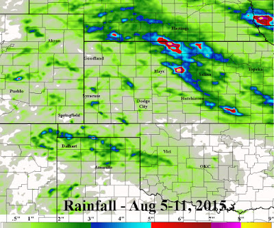
Here is the 7 day cumulative amounts ending yesterday (11th). Click for a larger version.
The thing that stands out to me is the exceptionally varying amounts of rainfall that fell during the period. First, the northern Texas Panhandle and Oklahoma panhandles remain very wet! Then there are those "isolated" pockets of excessive rainfall across southwest Kansas and eastern Colorado. Then finally the exceptionally high amounts of rainfall that fell from southwest Nebraska, southeast into central Kansas. So, some benefited greatly, some missed out and some had way too much rain.
As far as temperatures, there was one very hot day across Kansas, but otherwise temperatures were at least seasonal to below normal. The growing degree days across the corn belt made positive gains but units are still running below normal for the season.
Looking at the satellite from this Wednesday afternoon...
The upper level ridge of high pressure that has periodically made an appearance this summer, is building again stretching from west Texas into the northern Rockies. This pattern will shut off rainfall from the midwest into Kansas for at least 3-4 days. The exception is that a small area of thunderstorms may form during the night time hours across western or central Kansas - similar to what happened early this Wednesday morning. If this does repeat, it could be both Wednesday night and Thursday night, but is not too likely to happen.
The focus for additional thunderstorms for the high plains (better chances) will occur late in the weekend or first of next week. See that "L" off the northern California coast? That will lift north and then east and will usher in a front at that time. Beyond early next week, any heat should be mitigated with only normal to even below normal temperatures expected. Additional thunderstorms are possible next week.


No comments:
Post a Comment