Wednesday, July 30, 2014

Update to widespread rainfall event - 7/30/14

Quick update - got to hit the road so will have a more in depth review perhaps Friday...

Per the previous post (click here), the widespread rain event had moved out of Colorado and was moving into south central Kansas and Oklahoma early this Wednesday afternoon (7/30/14).  The precipitation map shown below is not complete and shows ONLY rainfall up until 700 AM.  Much heavier rains fell and I will update a map on the next post.  The heaviest rainfall I've seen reported in Kansas has been around 5 inches near Greensburg (around 2.50" as of 7 AM).  In general it looks like widespread 1 to 2 inches (some more, some less) across much of the area.  North central Kansas, including the Hays area, mostly missed out on this event.


The setup for this episode was "near perfect" as depicted on the following chart showing conditions around midnight last night.  I'm a little surprised that there weren't more areas that received over 5 inches, but I guess we can't complain about what we got.


If you're interested, here is the discussion from the heavy precipitation forecaster that generated the map (it's technical - just showing what was being discussed)...

DISCUSSION...THE LEADING EDGE OF MONSOONAL UPPER DYNAMICS AND
MID-LEVEL LOW FROM THE CENTRAL ROCKIES IS BEGINNING TO ARRIVE INTO
THE SOUTH CENTRAL PLAINS EARLY THIS MORNING. IN FACT... RADAR
IMAGERY CLEARLY SHOWS MULTIPLE SMALL SCALE MESO LOWS OVER ERN
CO/WRN KS ADVANCING SOUTH AND EAST OR ALONG A SURFACE BOUNDARY
BECOMING BETTER DEFINED OVER TIME. ADVECTING NORTHWARD TOWARD THIS
BOUNDARY AND MESO LOWS IS INCREASING LOW LEVEL MOISTURE AND AN
ACTIVE NOCTURNAL 850MB LOW LEVEL JET... RESULTING IN POOLING OF
1.5-1.6" PWS WHICH MAY INCREASE TO 2". COMBO WATER AND IR SAT
IMAGERY SHOWS A FLOURISH IN COLD CLOUD TOPS INDICATING RAPID
INTENSIFICATION OVER SERN CO/SWRN KS. THIS APPEARS INVOF OF SLIGHT
250MB UPPER JET COUPLING... LEFT EXIT REGION OF A 50KT STREAK OVER
THE FOUR CORNERS REGION AND 90-110KT RIGHT ENTRANCE REGION STREAK
ALONG THE ACTIVE POLAR FLOW OVER THE CENTRAL PLAINS/MID MS VALLEY.
THIS SHOULD RESULT IN A SORT OF ATMOSPHERIC SQUEEZE PLAY OF HEAVY
RAINFALL. THE GREATEST THREAT APPEARS LIKELY NEAR THE FRONTAL ZONE
FROM SERN CO INTO SWRN KS AND MORE ISOLATED THREAT OVER THE OK/TX
PANHANDLES... WHERE THE GREATEST INSTABILITY EXISTS. EXPECT
POSSIBLE RUNOFF AND PERHAPS MORE LONGER DURATION FLOODING THAN
FLASH VARIETY WITH 2-4" INCHES POSSIBLE AND LOCALLY HIGHER VALUES.


The 1115 AM Wednesday morning satellite map shows the transition of the upper feature that was depicted on the previous post.


As of 1210 PM, the rain was exiting southwest Kansas.


I hope to post again on Friday, time permitting.


Tuesday, July 29, 2014

Quick Update - July 29, 2014

Due to time commitments at the office and several workshops I've attended, I will not be able to go into a detailed post.  I just wanted to update on the potential for widespread rainfall (and excessive at some locations).

The latest water vapor imagery below shows a kink in the tropical jet stream (denoted by the L).  This system has tropical origins and thus has already helped to generate very heavy rain across southern Wyoming and Colorado this afternoon and evening.  As of 900 PM rainfall up to 8 inches has fallen near Eads in east central Colorado.


The setup is just right for a band of excessive rainfall from Colorado into Oklahoma.  The excessive rainfall may be narrow in width but some areas from west central Kansas and southeast into Oklahoma will receive over 5 inches of rain from this system tonight and Wednesday.  It is still a little unclear where to pin point this but the heavier rain could end up anywhere from Garden City to Liberal and maybe near Dodge City, Meade and Ashland.  Everyone across the western half of Kansas will get at least some rainfall.  The latest radar as of 925 PM CDT shows an expanding area of thunderstorms with heavy rain over Colorado and far western Kansas with "feeder bands" extending into northwest and central Kansas.  This area was moving east and southeast.


When I get back from my trip (or I might get to it Wednesday morning before I leave) I will give an in depth view of the improving drought situation.  As it stands from the 22nd there continues to be improvement on the long term situation.  More later....


Saturday, July 26, 2014

Short Update - Jul 26, 2014

I'll do a more in depth post this coming week.  But, I just to do this short post because of the outlook coming up.

As expected, it heated up this week with Dodge City finally reaching the century mark on both Friday and today (Saturday).  But, that's it for a while!  A change back to cooler (much like right after the 3i show) weather this coming week is forecast with chances for precipitation.


Looking at the Saturday afternoon satellite image I denoted two areas of interest.  One is the deep southerly fetch of copious tropical moisture moving out of Mexico and into the Rockies and then east into the central plains.  I discussed this a couple of posts ago as being the North American Monsoon.  The second area of interest is the "strong" jet stream coming out of Canada (denoted by blue) and this is what will bring the cool down this week (the associated front will be moving through Kansas Saturday night and Sunday.


But, the  image I wanted everyone to see is the copious amounts of moisture that is forecast for the southern part of Colorado and northern New Mexico.  This forecast is being generated by the Weather Prediction Center out of Washington DC (formally HPC) is shown below and that is the possible rainfall amounts from Saturday (today - July 26) through August 1st.  This is an average, meaning that some areas will get less while others could get a little more.  That amount of almost 9 inches in the southern parts of Colorado is a copious amount!  IF that verifies, there will not doubt be flooding problems.  While some of that will go down the Rio Grande in New Mexico, there will also be a lot of water going into the Arkansas drainage basin.  We'll see how that pans out but the pattern is certainly favorable for this type of event to unfold.  For me, as a Meteorologist, this is really exciting to see how this might pan out because the setup could actually result in flood warnings for the Arkansas River west of John Martin Reservoir and would not be the first time this year.  This will also continue to make a dent in the drought, even for the southern plains and which could also have a feedback mechanism for weather later this fall.


I hope to update this on Tuesday (maybe Wednesday as I have extensive Decision Support training this Monday-Tuesday).  Also, I'm gaining some confidence on the outlook for the Fall/Winter, at least for temperatures and I might touch on that in the next post.

Monday, July 21, 2014

July 21, 2014 Update - Wet and Green - Except for a Few

The past week saw quite a change in weather with record temperatures observed across much of the plains. Normally we talk about record highs, but this time it was for record "cold" temperatures, as was expected and noted in the previous post. See the previous post here.   At the Dodge City airport we had the coldest three day stretch of high temperatures for July since records started back in 1874!  The daily average temperature tied for the coldest stretch too!


Along with the "cold" temperatures there was widespread rain and drizzle but unfortunately (for some) the amounts were rather disappointing.  The heaviest rains fell from Jetmore to southwest Barber county and also across the area from Elkhart to northwest of Liberal.  In these areas amounts of 1 to 3 inches were common with several 4 inch amounts reported.  But, there were also areas that received only a small amount of rainfall.


In the post last week I had mentioned the heavy rains that had fallen across the foothills of Colorado and adjacent plains of southeast Colorado that produced flash flooding.  There was a large volume of water flowing down the Arkansas River, both above and below John Martin Reservoir.  Additional heavy rains fell during the remainder of the week and it appeared that water might actually make it to at least Garden City. Hmmm.  It is SO apparent that irrigation has a dramatic impact on water in the river.  All or almost all the heavy flow of water was diverted into the irrigation ditch system (and into privately owned Lake McKinney in Kearny County).  Water flowing down the Ark had been diverted into four irrigation canals; 1) Frontier Ditch near Coolidge; 2) Amazon Great Eastern Ditch near Lakin; 3) Southside Ditch near Lakin; and 4) Farmers Ditch near Deerfield.  Look at the water flowing through the Amazaon Great Eastern Ditch! WOW!

That is 350 Cubic Feet per Second of water going through just one irrigation ditch! That is a heck of a lot of water!  So, not only has the water NOT reached Garden City, it hasn't even reached Deerfield!  To me that is disappointing and amazing!

Off the soapbox...

The additional rains last week have helped a little in terms of the drought.  Much of Kansas and the central/southern plains still are in an extreme or exceptional drought due to the length of the dry spell before the rains.


At Dodge City we're doing pretty good since October 1, 2013.


But as mentioned in the previous post, there is still a huge deficit since the beginning of Water Year 2010.


Outlook for this week and into August

In a previous post I had mentioned the North American Monsoon (it's not a "real" monsoon).  The pattern is still set up just fine with copious moisture moving north out of the Mexico into New Mexico and Colorado.  The only problem?  Temperatures in the plume are unusually warm which is now preventing widespread thunderstorms!.  The satellite image below shows the flow of moisture.


Typically in this pattern there would be numerous afternoon thunderstorms across the Rockies (as there was last week).   Still, there should be convection, just not quite as widespread as normal and some of this will drift into Kansas.

Our attention is now drawn to the upper low over California (the L) and the jet stream across the Pacific Northwest.  In addition (not on this map) there were several typhoons across the western Pacific.  The typhoons will force the jet stream to buckle and will take the California low north, east and then southeast into the midwest towards the end of the week.  The result will be another cold front into the plains, but not as cold as last week.  The upshot will be cooler (not colder) temperatures and an increase in opportunities for thunderstorms by next weekend (July 26-27).

So, the weather pattern is NOT expected to become stagnant with day-after-day of 100+ degree weather. Rather, there should still be periodic fronts (some stronger than others) for the balance of July and into August.   With these fronts there should be a continued chance for thunderstorms on occasion although nothing widespread is on the immediate horizon.  Hopefully those unlucky ones that have not benefited from this active summer will finally get a rain or two.

Looking deeper into August there are some signals/signs that the month may not be too hot - or dry!  One of the long range computer models actually is forecasting MUCH below normal temperatures across not only Kansas but also across the Corn Belt.  I know that much of the corn was planted late this past spring and we need to start thinking about if the corn in that area will be able to mature before the first freeze.  Something to think about and watch.

August can be a real tricky month to forecast for as the jet stream is typically at it's weakest across the northern hemisphere.  Any notable and repeating pattern usually dies out completely during August so we have nothing to go on other than looking for subtle changes in the flow aloft and at the surface.  If I had to make a guess I would go for near to slightly below normal temperatures and near normal rainfall.  Again there will be those that receive less than normal rain and those that get quite a bit.  There should still be hot stretches but not L O N G stretches.

BTW, we CANNOT make an assumption about early freezes and winter weather based on what happened during the summer.  The pattern will re-establish itself by late September or early October as the flow aloft increases due to the changing of the seasons.  At that time we can get an idea on what is possibly in store.  I will say, however, that looking strictly at records that the following winters after a record cold spell in July that most have tended to be dry and cold.  Caution:  I'm not saying that will be the case this winter.  Give me a month or more to start looking at that.

Lately temperatures across the Arctic have been below normal and the phase of the Arctic Oscillation (AO) has tended to neutral and is expected to go to slightly above.  But, if conditions continue as such across the Arctic and the phase of the AO goes strongly negative then I would expect a VERY sharp cool down into the Midwest and possibly central plains.  I'll keep an eye on that.


I hope to update again around July 30.

Monday, July 14, 2014

Update - July 14, 2014 - Rains and a BIG cool down

As discussed in the June 26th update, the atmosphere finally gave up the fight to summer.  The flow aloft had significantly decreased across North America and the 
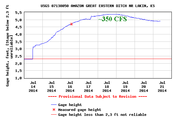
North American Monsoon has commenced.  There has already been heavy rains across parts of the Rockies of New Mexico and Colorado.  In fact, a very heavy rainfall event occurred across the eastern plains of Colorado over the weekend resulting in flash flooding in the Rocky Ford, La Junta and Lamar areas and adjacent areas of southeast Colorado.  The Arkansas River responded with high flow headed towards the Kansas/Colorado border.  There might even be enough flow to eventually make it to Garden City and perhaps even farther east!  The graph that follows shows the increasing flow (cubic feet per second) along the Arkansas River near Granada as of Monday afternoon (July 14).


Now if you read carefully above you might have caught that I said the flow aloft HAD significantly decreased.  But as of this writing the jet stream has strengthened and dipped WAY south into the upper midwest.  It is definitely an anomalously strong dip south and anomalously strong jet stream for mid July.  This dip is sending a significantly strong cold front south into Kansas and eventually into Texas.  Unfortunately it was too strong to help bring widespread thunderstorms to the high plains although scattered storms did develop as they moved into Oklahoma.

The following map shows the position of the jet stream and upper flow and other features...


A notable feature on this image (from Monday afternoon) was the low over northern Idaho.  This system should drop southeast as it rounds the corner from the anomalously strong system over the upper midwest.
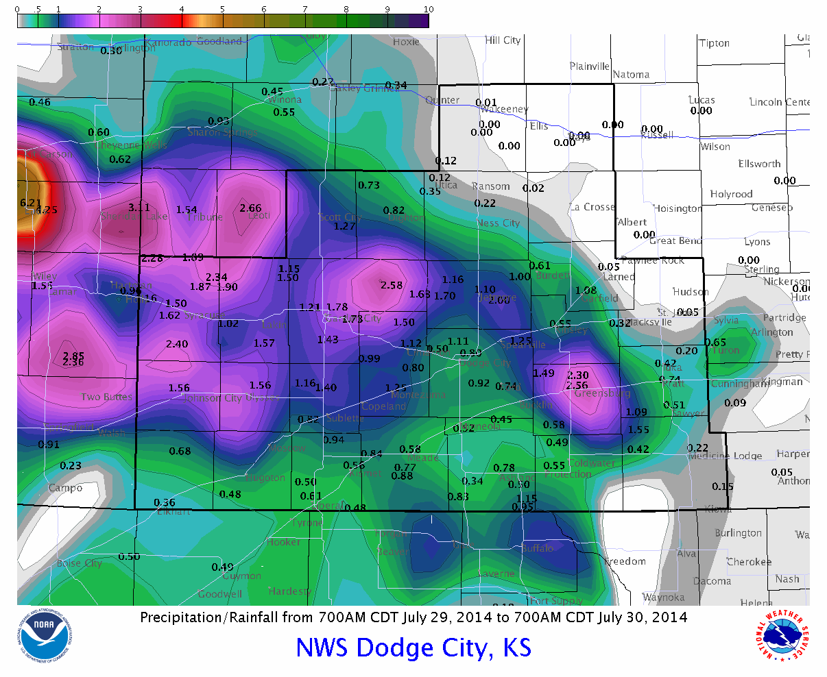
The result should be rather widespread rain and thunderstorms from late Tuesday into early Thursday.  In addition, temperatures across the corn belt and much of Kansas will be much colder than average for the remainder of the week (14th - 19th).  There may be some records set, especially given the fact that highs across the eastern 2/3 of Kansas may struggle to get out of the 60s on Wednesday!  As for rainfall, the Weather Prediction Center is fairly confident with the rainfall.  The following map depicts expected precipitation through Sunday night July 20th.  Not everyone will get this much precipitation, while others will get even more than that!  This is just an expected average.  This is great news from parts of Texas and Oklahoma where it has been getting increasingly dry again...

The convective season (considered to be the warm season months) has brought a lot of rain to much of Kansas but sadly there are still areas that have missed out (by chance).  The following map shows an estimate of rainfall since April 14, 2014...


One area south of Mulliville, KS in Kiowa county has had a little over 20 inches during this period!  WOW! A large part of the region has had much above normal amounts during this 90 day period, while other locations across the far southeast parts of Colorado and southwest Kansas have received much, much less.

Even with the much above normal rainfall for late May and June, there is still a huge deficit of precipitation over a longer period.  At Dodge City at the airport, precipitation was above normal for the period October 1, 2013 through July 13, 2014 (considered part of the 2014 Water Year).


But going back to October 1, 2010 the deficit is pretty clear...


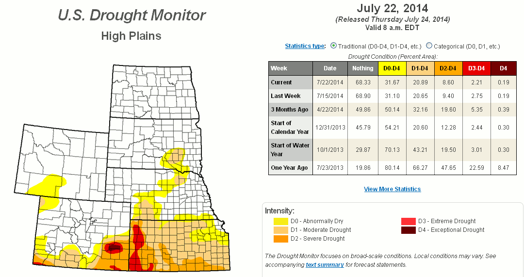
It's much the same across the entire high plains area.  So, it is not surprising that much of the region is still technically in a drought.


Outlook look for the remainder of the summer.

The NA Monsoon mentioned above should continue into early August and will be robust at times.  I'm confident that southern and central Rockies will have above to much above normal rainfall into August.  The adjacent plains should also see above normal rainfall.  There is still a question on how far east this will get into Kansas.  Even though it will be getting hot again across Kansas (and with a smattering of 100's) next week, there will still be additional cold fronts enhancing the opportunity for convective events into August. With moderate confidence, rainfall for all of July should be normal to above (again there will be unlucky ones with below normal liquid).  The average temperature for July should end up below normal across much of the high plains.  Will we reach 100 in Dodge City this year?  Probably, but not many times.  I'm going for 3 so we'll see.

Later in August I'm not seeing a huge change.  There will still be a few fronts but I'm not seeing the blast furnace type of weather that we sometimes get.  Overall for August, I'm looking for near normal temperatures and near normal rainfall, if not above.  More on August at a later time...

Finally, what about El Nino?


The Southern Oscillation Index (SOI) is a measure to where we can see the progress of a developing El Nino or La Nina.  To have an El Nino, the numbers should be significantly negative for an extended stretch (like 3 months).  That green line above should be negative.

If you read back through earlier posts I had mentioned several times that there was a question about the strength of El Nino, or if it might even develop!  Much of the media and national weather enthusiasts have been predicting a "super" El Nino.  I just don't see that happening and I'm really starting to wonder if one will develop at all!  Regardless, other forcing mechanisms across the globe are calling the shots for our current weather regime.  What I'm saying is we don't need an El Nino (ENSO only partly influences our weather across Kansas anyway) to get beneficial weather.

I'll try another update in about a week.  I might even give a hint to some early thinking for the late fall and winter too.  It's still early but I'm starting to have a hunch.

Saturday, July 12, 2014

Update is coming soon...

To those that I visited with at the 3i show in Dodge City this past three days (Thursday - Saturday) and to those that I did not get to visit with...I'll be updating this blog on Monday.  I've had a very hectic schedule recently that has prevented a timely post.  While I'm updating this currently, a large area of rain and thunderstorms had developed late this Saturday afternoon and evening across southeast Colorado (July 12).  This is in advance of MAJOR changes coming this week in terms of colder (not cooler) conditions.

More Monday...