The title - of course there is. All dry periods (droughts too) are broken. But how much can we endure before favorable weather returns? In previous posts going back a long way, I had pointed out numerous times that, for instance, Dodge City experienced 7 years in a row (2014-2020) of above normal precipitation. It was almost 9 in a row as 2013 and 2021 were just a little bit below the annual average. From 1875 through the current time, there had never been more than 3 years in a row. So, this was highly anomalous to have that many "wet" years in a row. The pendulum was going to swing the other way, there was no doubt about it.
Remember, the high plains region is considered to be semi-arid and the farther west towards the front range (from New Mexico into Canada), the more likely it is that the year or season will be dry. That is just a fact of life. Even with dry years (or seasons), crops have been raised without irrigation. Obviously, production will be limited in many cases (depending on the environmental conditions during the growing season). This year and season have been brutal for many. Will it continue into 2023? I wish it was easy to say one or other but there are just so many factors/issues that influence sensible weather, especially across the high plains.
In the previous post I did on October 28 (read it by clicking
here), I discussed again about the new weather pattern that was setting up. The new pattern then and as it is today (the 4th of Nov) was and is still young. I have been mostly discouraged but yet there had been and continue to be at least a few signs of promise. The last one is the system that is moving out of the Texas Panhandle today. Overnight there was a fairly large area of rainfall and here is a map of what had fallen as of 9 AM this Friday morning...
Granted, many of the areas hardest hit by the drought and dryness had largely missed out, AGAIN! But the system was still likely to produce at least some rainfall (and snow) farther west. This type of strong system will make more appearances later this fall and winter. Even though not all areas got or will get precipitation, the evolution of the system is slightly encouraging.
Speaking of precipitation, the October amount was awful. Dodge City (airport) got just a trace, and this has happened only 2 other times in recorded weather history (back to October 1874).
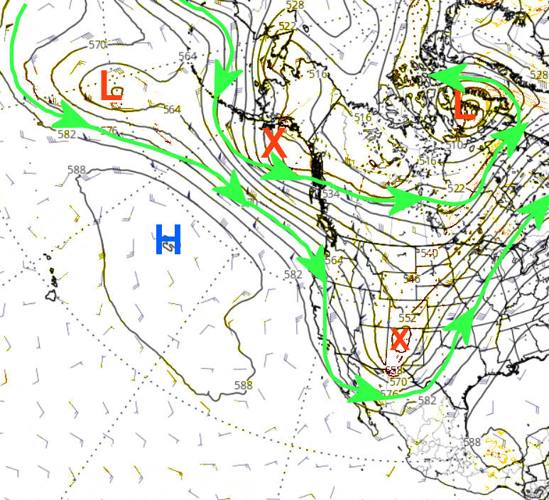
As of this morning, here was the upper level map of the jetstream.
The red X approaching the Texas Panhandle was small but mighty. The red X moving across the Gulf of Alaska will amplify into a deep trough across the western U.S. which will promote warmer and windy conditions across much of the high plains later this weekend and into the first of next week. The eventual evolution of any system moving out into the plains will likely be towards the end of the week but there is much uncertainty.
Not shown by a map or chart, but there is a decent Madden Julian Oscillation across the Western Pacific. Forecasts are pretty consistent on its expected movement and evolution. It would "favor" much colder and perhaps wetter weather centered on mid-November. Maybe between the 12th and 18th. Without knowing much about this new weather pattern, confidence is only slightly there for that mid-November weather outlook.
For an outlook taking us into next spring.. well without knowing details of the behavior of this new pattern that is just developing, I don't really have an answer. Can I look at history? I could, can and will but don't put much stock in it.
As I mentioned in the previous posting, the current La Nina will likely continue through the winter which would be the third winter in a row of a La Nina. This has only happened two other times (1973-1976 and 1998-2001). That is only two events to go off of so that isn't much at all. But lumping the two events together, for the high plains the November-April weather averages out to near normal precipitation and below normal temperatures. Again, don't put stock in it. Once this new pattern has completed its first go round, confidence should increase on an outlook into the growing season of 2023. For now, definately temper expectations. I'll try and update later next week.