Thursday, June 25, 2015

The clock is ticking - update 06/25/15

In the last several posts, I eluded to a continued period of favorable winter wheat harvest weather.  I also mentioned taking advantage of that weather, because I did not believe it would last.  The clock is ticking...

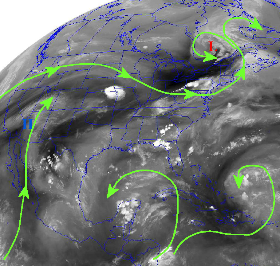
Overnight Wednesday night a huge and very proficient rain producing MCS (Mesoscale Convective System) moved across parts of the corn belt.  Copious amounts of rain (too much in a lot of locations) was observed in parts of Iowa, Illinois, Indiana, and Missouri.  Across the  central High Plains it continued to be dry.  (click for a larger version)


There is a front sliding south into Kansas this Thursday afternoon.  In the upper atmosphere there are a couple of disturbances moving southeast that will enhance the opportunity for storms across the central part of the country.  There will be storms early along the front and then a probable MCS moving out of Wyoming, western Nebraska and Colorado will follow during the overnight hours.


This MCS should impact a large part of the High Plains.  Some areas will receive a pretty good soaking (1 to 2 inches of rain) while others may see on the order of 1/4 to 1/2 inch.  There likely will be quite a bit of wind with the system, but not much if any hail.

Once that system moves by, the majority of Friday will be dry and almost certainly dry over the weekend (with the exception of the Rockies and adjacent foothills).

Looking ahead....

Other than the storms tonight, it should be mainly dry (and cooler over the weekend).  It will be warming during the first of the week and this favorable harvest weather will last until about mid-week next week.  But, as I have stressed in the previous posts here, that favorable window of opportunity to get the harvest completed and other field week accomplished, will be closing fast.

It is starting to look more and more likely that MCS's will begin to impact the plains almost nightly beginning as early as Wednesday night (July 1).  Not everyone will get rain, but a large percentage will.  These nightly occurrences could last through the weekend.

Then, it looks like MUCH cooler temperatures (higher humidity too) and wetness will arrive, most likely after the 4th.

One observation I've made over the years is the trend of what is called the Southern Oscillation Index.  It is a value that is calculated based on surface pressures between Darwin and Tahiti.  It is one measure of an El Nino or La Nina.  I've noted that when the index value crashes (decreases rapidly) it typically is followed by a colder regime across the central part of the country.  I'm not totally confident of a summer-time response, but all indications point to significant cooling.  There is also some tropical weather trying to form across the western Pacific and this would also lead to downstream energy propagation and would support significant cooling.

Here is a chart of the SOI index (click for larger version)....


The two previous SOI "crashes" were followed by much colder weather!

The cooling may last several weeks (on average).  Any additional rains would also act as a feedback mechanism in keeping temperatures down that could even last into August!   One of the longer range forecast models has consistently pointed to a colder than average July.  The latest run continues to support that notion.   In that output denoted below,  the gray areas are ranges of possibilities based on ensembles.  The black line is the average.  If this was to verify, it would have a negative impact on Plains corn growth as the growing degree days will be significantly less than normal.


Next update - probably June 29.


Tuesday, June 23, 2015

Quick update (06-23-15)

In the previous post I did on the 18th (click here), I discussed the drying pattern for the winter wheat harvesting areas.  So far, that has panned out perfectly.  I also mentioned that the window of opportunity might be closing though by the end of the month.  That still appears to be on track.

Looking at the satellite image (click for a larger version),


there were hints of the North American Monsoon starting to form (very early stages) as moisture aloft begins to move north through the Rockies.  What is preventing widespread precipitation across the plains is very warm air aloft and sinking air (from a large upper level ridge).  But this will be breaking down a bit and shifting west.  So, the very warm to hot weather with limited thunderstorms and gusty surface winds is about to be temporarily shut down.  A cold front will move into the central high plains by Thursday and will bring a round or two of thunderstorms and cooler temperatures (and higher humidity).  The WPC has the following solution into next week (for precipitation).


The heaviest rainfall by far will be across much of the corn belt.  Hopefully, there won't be enough rain to completely shut down the wheat harvest, but no doubt a few spots will see a couple day delay.  Towards the end of the week and into early next week there will be limited chances for thunderstorms across the high plains.  Rainfall will, however, be ramping up a bit across the Rockies and adjacent front range.

The kicker will be late next week and into the 4th of July weekend and week.  Significant changes may be taking place, especially towards the 3rd-5th of July.  If the changes take place, that I'm expecting, the opportunity for rainfall will increase significantly and temperatures will drop to below normal.  I guess the headline there would be "Expect Weather Delays Going Into July".  I'll have to have a bit more time to discuss this, and I hope to by the end of this week.

Thursday, June 18, 2015

Improving Wheat Harvest Weather - Updated 6/18/15

Now that the remnants of "Bill" are getting out of the picture, the weather pattern is gradually becoming more early summer-like.  Looking at the satellite image, there are several features of importance.  Click for a larger version if you like.


Obviously the biggest feature is what is left of what was once Tropical Storm Bill.  Along the track of that system there was unfortunately very excessive rainfall and resultant record flooding (on-going).  Probably the biggest element it brought to the high plains was an increase in boundary  layer moisture.  Another feature, that was unexpected by most accounts, was the MCS (Mesoscale Convective System) that brought a late night/early morning round of thunderstorms to Nebraska and northern Kansas this morning.  What was left of that MCS has fired into additional thunderstorms across the northern Texas panhandle this Thursday afternoon.

The other important feature is the "H" across southern California.  This is the beginnings of a ridge of high pressure in the upper atmosphere that will build into the plains for the balance of this week and into much of next week.  A forecast challenge that will exist is just how hot the temperatures will get above the surface (we call this the EML - Elevated Mixed Layer).  If the air gets too warm aloft, it will help suppress thunderstorm activity across the plains.  This is actually the most likely scenario.  That is, for the most part, much drier weather can be expected into the latter part of next week.  Plus, with increasing daytime temperatures, some wind and in general a little less humidity, the opportunity for ripening winter wheat should commence.  There could still be scattered storms around - but the coverage should be at a minimum

Here is the outlook by WPC - the Weather Prediction Center - for the next 7 days.

Even though the weather may become more favorable for grain harvest, haying operations or other field work, there is likely still issues with wet or muddy fields.  I can only imagine this as look at the rainfall for the past 7 days.  (click for a larger version).


It amazes me the amount of rain that fell in parts of Oklahoma the past week.  Nearly 20 inches in some locations!  Parts of Central Oklahoma have had 40 to 45 inches of moisture since the first of the year!

Looking ahead

I'm afraid in a week to 10 days there may be several cold fronts enter the picture.  Not only will they bring cooler temperatures but also an increase in chances for storms and higher humidity.  I can see the pattern becoming more favorable for late afternoon through overnight thunderstorm complexes moving out of the front range areas of the Rockies toward the last 3 or 4 days of the month.  July still looks wetter than average too, at least at this point.  Take advantage of favorable weather while you can.

Monday, June 15, 2015

Drying out across the high plains - but look out to the east (updated 6/15/15)

In the past few posts there was much discussion about copious amounts of rainfall that was possible.  During the past 7 days there was excessive rainfall!  (click for a larger version)


That map would typically look like an entire months worth!  Some areas had a ton of rain while others generally missed out on the heavier amounts.

There are now changes taking place across the northern hemisphere which will bring a drying trend, at least to the high plains.  The jet stream will be become more westerly with time and will shift north.  Although there will STILL be thunderstorms scattered across the plains, the spatial coverage will be decreasing.  There will be one or two higher chances - say mid week and late in the weekend.

However, now attention is drawn to a tropical system gaining strength over the Gulf of Mexico.  Although it won't become a hurricane, what it will become is a tremendous rain producer.

Looking at the satellite...

There is general high pressure building over the south tip of Texas.  North of that high the flow is from south to north and there was a small disturbance across southwest Texas.  This "might" produce more thunderstorms late Monday into early Tuesday moving up into south central Kansas.  The chance is small.  More importantly is the "L" over the gulf. This is the tropical system that will likely become at Tropical Storm before moving ashore.  There is a VERY high amount of moisture available for this system.  Thus, there will no doubt be copious amounts of rainfall along the track of this system during the week as it moves into Missouri.  Some areas will receive enough rain to cause extensive flooding, unfortunately.

CAUTION!

The eventual track of this tropical system is not set in stone.  Here are possible solutions from various forecast models:


The point with a map like the one above is that the threat of heavy rain could be farther west than forecast OR it could end up farther east.  The western and eastern edges will be in the "uncertain" areas.  The Weather Prediction Center (WPC) offers the following outlook for the amount of rain through the week:

The forecast from WPC basically ignores the possibility of the tropical system tracking farther west, like some of the solutions in the track map have.  If this is just based on historical tracks for this time of the year, then the outlook given by WPC is probably not too bad.  At this point, that is what I would lean toward.

I'll try and update in a few days...

Thursday, June 11, 2015

Quick update - 06/11/15

Please read the post I did on Tuesday (click here) for the background synoptic situation pertaining to the heavy rainfall event that is unfolding.

In the previous post I discussed the anomalously high amount of water vapor was being drawn north into the U.S., as much as 300 percent of normal.  That hasn't changed today, except that the deep tropical moisture is now farther north and spreading east.  Click for a larger map.


The upper storm that had been west and southwest of  Los Angeles, CA was now moving toward the Rockies (the "L" near Las Vegas). 

 
At the same time a cold front was dropping into the western high plains.  The stage is set for several days of widespread showers and thunderstorms.  With the atmospheric setup, a lot of the storms will have high rainfall efficiency.  Even as this aforementioned system decays/weakens as it moves into the plains, the atmosphere could remain unstable enough for additional rounds of thunderstorms into next week.  All weather computer models made available have been consistently wet with varying amounts of rainfall.  Each model will have a different solution in both quantity and spatial locations.  But the bottom line, heavy rainfall potential is exists.  Just as an example of the output from one of the models (GFS), look at what it predicted (from last nights iteration)!  This is it's prediction for rainfall accumulation through the end of next week.


DO NOT TAKE THE AMOUNTS OR LOCATOINS AS GOSPEL TRUTH!

 Each time these computer models are run (every maximum of six hours), the location of the heaviest rains shifts in location.  The extreme amounts of rain (13+) is likely overdone in an areal sense,although an isolated spot could get close to that over the next week.

There are two areas of concern during the next 48 hours.  The highest concern is probably along the continental divide and out into the eastern plains of Colorado.   The heavy rains will accentuate the snowmelt producing some serious flooding.  Into Kansas and the panhandles of TX and OK the excessive rains may also cause flooding concerns.  Plus, any planting of fall crops will come to a halt and certainly the early harvest of the winter wheat.   If anything close to the above map comes to fruition, there will be fields under water for weeks.

Tuesday, June 9, 2015

Build an Ark and plant some rice - Updated June 9, 2015

In the previous post I did on the 6th (read that post by clicking here) I discussed the exceptional rains that fell in May across much of the central U.S. and the outlook for additional precipitation, especially for the later part of this week and into next.  As of this morning (9th), the atmosphere is certainly coming together to make that a reality.  And I have some concerns.

First, in that previous post I talked about Hurricane Blanca.  That unusually strong (for early June) and land impacting hurricane came ashore across the Baja of California and has now almost entirely dissipated.  But, it has moistened up the atmosphere across the southwest U.S., to a tune of 300 percent of normal! This is extremely unusual for this time of year.  A Precipitable Water Vapor map, which follows, is a measure of the amount of moisture in the air from surface to the top of the troposphere.  Click for a larger version.


One reason why there should be concern is that this amount of moisture, while being very unusual for this time of year, will be made available for thunderstorms, not only across the plains but also across the high country of the Rockies.  Precipitation efficiency in these storms will be high meaning that heavy rains will be likely.  Snow melt is just peaking (with a lot of snow still up high) and if these storms occur over the basins of the melting snow then flooding (possibly major) will be highly likely!

Into the plains, there should also be heavy rain producing thunderstorms from late Wednesday into next week.  Not only from the remnants from Blanca, but from other weather systems that will be tracking east.  Look at the satellite image.  There is one particular storm just west of LA, California.  Another is southwest of that.  Both will be slowly tracking towards the center of the country during the next week to 10 days.  Excessive rains falling on river basins that are already running high may create some serious flooding!  Obviously this will also come at a time that wheat will be maturing and will disrupt any late plantings of sorghum or beans.


Although specific details will be impossible to predict, overall there should be widespread thunderstorms off and on during the period across the central part of the country.  The Weather Prediction Center forecast for average precipitation into early next Tuesday is pretty impressive, and for what its worth, is probably a pretty good approximation.  That is a lot of rain for areas that had record or near record May rainfall!  NOTE:  NOT ALL LOCATIONS HIGHLIGHTED WILL SEE THIS MUCH RAINFALL!


Even beyond next Tuesday there will be additional rainfall.  In fact, several  of the long range computer models generate a ridiculous amount of rainfall through June 17th for some locations, and there is meteorological reasoning to believe it!


Saturday, June 6, 2015

Shades of '93 - sort of (update 6/6/15)

In the blog post I did on June 1st, I discussed the wet pattern shifting north.  Read that post here.  As expected, the wet pattern did indeed shift north as evident by the copious amounts of rainfall and even severe weather that has occurred from northeast Colorado across Nebraska and into northeast Kansas & NW Missouri.  There have been numerous rivers in flood stage or above, or at least at levels that have not occurred in a long, long time.  Look at the map depicting where rivers are running way above average (denoted by the black circles).  click on the map for a larger version.


Why did I put "Shades of '93 - sort of" in the title?  Not really because of the overall weather pattern (it's different than 1993), but because the area with the abnormally high river levels keep getting MCS (Mesoscale Convective Systems) almost daily/nightly just like in 1993.  Plus, it's really not likely to change much, overall, for the next few weeks.

Look at the percent of normal of rainfall over the past 30 days.  This is VERY impressive!  Many locations have had 2 to 5 times the normal amount of rainfall.  So, add what is expected and what has occurred, and the river flooding (that had been across Texas and Oklahoma) will soon be or is imminent across these other areas.


What is expected during the next 7 days (from the Weather Prediction Center)

With the recent rains the long term drought is just about completely wiped out.


Notice there are still areas that show a moderate drought.  Keep in mind this drought took a while to develop, and it always takes a while to end as this takes into account long time periods. 

The Hurricane

In the previous post I discussed a hurricane and tropical storm.  The tropical storm, Blanca, has since become an intense hurricane south of Baja California.  This occurrence, for this time of year, is extremely unusual as they normally don't get cranked up there until later in the summer (and being so intense this early).  There is still a fair chance that the remnants of this hurricane will impact parts of the plains (most likely late next week).  Already some of this moisture aloft has helped to produce abnormal rains across Arizona.  Flagstaff received more rain in 45 minutes than they normally get the entire month of June!

First, there is a vigorous upper trough across the west. (see the satellite below).  It has already contributed to the severe weather and heavy rains mentioned above.  A separate system (not noted on the satellite image) will drop into the midwest and it's associated front will drop into Oklahoma.  As a result, thunderstorms are expected to occur farther south on Sunday and Monday.  Once that goes by things should dry out for a few days.  But, then attention will turn to Hurricane Blanca.


IF the remnants are carried into the plains, look for more heavy rains late in the week.  I'll be watching this possibility very carefully as it this pans out, the extra moisture and thunderstorms could heavily impact the snowmelt that is on-going across Colorado.  That could result is some pretty serious flooding along the Front Range and mountains so folks out there will want to monitor the weather trends carefully.

Sidenote... I personally would like to see water finally flowing down the Arkansas to at least Dodge City this summer (hasn't happened since 2003).  What that will take is a "full" John Martin Reservoir (JMC) (eastern Colorado) and less demand on irrigation.  JMC has had steady inflow since May 1 with just normal releases and has gone from 13% full to 59% full.  Yes, even though the lake has risen 27 feet, it has a LONG way to go to get full.  But, with the continued runoff from rains and the influx of snowmelt, I think it will rise to full elevation/volume.  With the expected usage of irrigation releases to be less than normal and with the increased releases from a full reservoir, I think the water in the Ark will get past Garden city (99 percent chance) to hopefully as far as Dodge.

Looking ahead...the pattern should be a little more favorable for additional rains across even the central part of the high plains (not just Nebraska and northern Kansas) by the middle to late part of June.  This should be good news for those that run their pivots 24/7.  I still don't see the exceedingly hot weather than many still have been talking about.  The number of 100+ days this year across the central high plains should be limited.

Monday, June 1, 2015

Wettnes Shifts North - For Now (June 1, 2015)

The month of May - what a month!  As discussed often in this blog during the past 4 to 6 weeks and expected, this past month was a record setter at many locations in regards to rainfall and flooding.  Because of extremely heavy rains, many rivers reached record levels and unfortunately resulted in fatalities and copious amounts of damage.

The largest official amount I saw was for a location 8 miles east-southeast of Norman Oklahoma that recorded 29.89 inches...just for May!  In western Kansas there appeared to be many locations that had between 10 and 15 inches.  The largest amount officially recorded was just north-northwest of Dodge City that had 12.35".  At the airport in Dodge City, the official measurement was 10.33" and was the second wettest May on record.

Click on the following map for a larger version....


 For many areas this was 400 to 600 percent of normal, which is incredible!

During just the past weekend, the pattern was changing.  We will see a more typical early June jet stream and subsequent weather, at least for the next 1 to 2 weeks.  For the most part, there will be a lack of widespread and significant rainfall across Texas and Oklahoma.  Temperatures will be warming, but there will be a lot of moderation due to the water and explosive vegetative growth.

As the pattern shifts, the significant and widespread precipitation will shift into the northern plains but still be close to northern Kansas.  The Weather Prediction Center offers the following as a forecast and possibility during the next 7 days (through early June 8)...

 So, is that it?  In a typical early summer, this pattern shift would probably indicate the summer regime was commencing.  However, this year because of the extreme wettness across the central and southern plains, I've got to believe there will be some feedback mechanisms (from the surface to the atmosphere) that will take place.  Plus, the overall hemispheric flow of air should eventually transition back into what we just had, only it will be the summer version.  So, even though I agree with the above precipitation map above, I think that might only be temporary.  

The first clue might be what is happening in the eastern Tropical Pacific.  There are two tropical systems already!  One (Andres) is a hurricane and the second (Blanca) a tropical storm.  There is "some"  possibility that they will eventually turn northeast towards the SW U.S..  If they track this way, then all bets are off about a dry southern Kansas, Oklahoma and Texas.  I'm not buying into it yet, but will be watching closely.   


There will still be scattered convection across the plains, during this "dryer" period, it just won't be nearly as widespread as recent weeks.  Plus temperatures will be much warmer so that we will finally see some decent growing degree days (units).

The pattern this summer will be interesting to say the least.  Although June will be dryer than May, it could still end up normal to above normal.  Keep in mind that June is typically the wettest month of the year across the plains.   A lot of the long term climate models are indicating a response to the growing El Nino, in that some of the wetness may very well last throughout the entire summer.  More on that later.