Friday, March 25, 2022

An active pattern but will it benefit the high plains?

The strong weather system earlier in the week, centered on the 21st, did bring widespread precipitation as expected.  But amounts for some of the region were highly impacted by an early development of rain and thunderstorms across Oklahoma and Texas.    Thus, the storm total under-preformed for much of the high plains - which is obviously very discouraging. 

The large area of rain and thunderstorms mentioned above disrupted the flow of moisture into at least western Kansas.  Amounts therefore were not that heavy.  But as the storm system finally completed it's development and started lifting out into the central U.S., precipitation picked up again in intensity.  Towards the end the intense lifting of the atmosphere it cooled the column enough that snow fell.  It's honestly such a crap shoot to determine location, intensity and duration of precipitation and if it will flip to snow.  There are just so many variables that can impact actual amounts.  One variable is what I mentioned - the large area of thunderstorms that developed across Oklahoma and Texas disrupting the moisture inflow into the storm.  I've recently shared similar charts as the forecast from computer models seen below...

Precipitation forecast for Dodge City...


Here is the precipitation map from Monday into Tuesday....


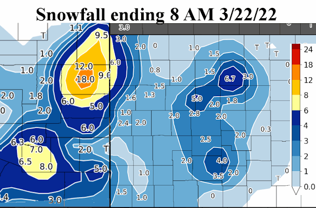
Here is a look of the snowfall for that Monday night (and earlier in eastern Colorado that was hammered).


Overall, here is a look at the amount of precipitation that fell with the storm (just in Kansas)...


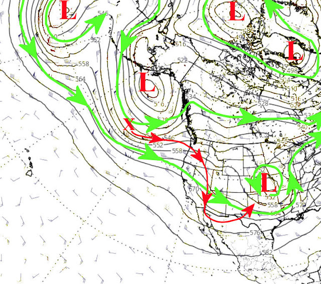
Looking ahead, my analysis does indicate another system for early next week.  But, there is a strong possibility it will move too far north and east of the high plains (and too fast) to bring much precipitation.  Eastern Kansas is another story.  There is hope, I'm just not too optimistic at this point. I'm counting on the remnants of the Madden Julian Oscillation mentioned in the previous blog post (click here to read that one).  Looking at the jetstream map from this morning, the potential system is indicated by the red X across the Pacific with one potential track overlaid on the map.


That system will have to intensify and track in a perfect location to bring much precipitation to the high plains.  Keeping fingers crossed.

Beyond that early week system, my analysis would indicate another possible weather system towards the end of the week.   It does exist just off the jetstream map above.  Surely one of the two will bring some moisture to the high plains.  At least the Weather Prediction Center thinks so.  Here is their map of precipitation for next week.


Going into April, the first 14 days of the month looks to be cooler that normal, on average.  There will be some warmer days though but offset by several more strong cold fronts.  There should be yet another weather system that could bring some moisture - somewhere between the 7th and 10th.  Beyond that second week, some of the computer models are indicating much above normal temperatures for the balance of April, and dry!  My early analysis would lead me to believe the average temperature for the entire month would be a little above normal but with the possibility of a late freeze.  More on that later.  Oh - and for those that have been reading this blog for a while.  Do you remember that magical date of April 20th that I mentioned several months ago?   Let's see what happens.


Friday, March 18, 2022

A temporary change in the pattern?

 Per the headline....the key may be "temporary".  Let me explain.

In the previous posting I did on the 11th (please read it if you haven't already by clicking here), I picked out March 18th as a potential weather event.  It was slightly faster but that is encouraging to me that it occurred across the high plains.  This storm was particularly difficult to predict, in terms of precipitation and especially snowfall.  It was nearly impossible to predict when (and if) the rain was going to flip to snow and just how soon.  The heavier band of snowfall was a bit less than the potential and shifted east by only about 20 miles.  The amount of liquid equivalent was almost spot on for many areas.  Here is a map of the precipitation followed by the amount of snowfall based on reports....


On this Friday mornings satellite you can see the snow left over and again where the heavier snow band set up.  


Leading up to the system, look at the ridiculous range of possibilities from the highest resolution forecast models, ranging from an inch to over 18 inches at Dodge City....

And forecasters are supposed to give you an exact number at your location?  Ha!

Ok, let's look ahead to this next system for next week.

So, again the 18th was a target date.  I didn't have a target date for next week (21st and 22nd), but when I reanalyzed some of my data there is a hint, but just a hint.  I think what maybe helped this system yesterday and last night and then a pretty good potential next week is that the Madden Julian Oscillation (MJO) became stationary and made a loop around the Maritime Continent. 


This "could" have had a temporary influence on the overall pattern.  That influence though will likely go away.  So what does this mean?  The system yesterday and last night was pretty strong.  The hint of a system next week looks to be impactful! 

Looking at the jetstream map....


The red X across the Pacific is expected to amplify (technical terms is a anticyclonic wave break), which should allow it to slow down and deepen into the southern Rockies.  Since the Gulf of Mexico moisture should be readily available, the precipitation  potential across a large part of the central U.S., will be very high.  We haven't had this type of opportunity since the widespread rains of mid-October.  Keep your fingers crossed.  Here is the outlook from the Weather Prediction Center...


I will try and do a brief update early next week.

Friday, March 11, 2022

Everything is still on track

If you go back to the previous post on Feb 24 (read it by clicking here), everything is right on schedule and pretty much as expected.  In the previous posts, even back a month to February 11th, I mentioned March 3-10 as having my attention.  That period worked out almost exactly!  Of course the high plains was too far west to benefit on the earlier systems but at least "most" of the region received some precipitation with the last of the events for this period.

The first event on March 4 had some thunderstorms across southwest Kansas but because of very dry air, only a few hundredths of an inch was observed.


That system eventually produced the deadly outbreak of thunderstorms and tornadoes across Iowa and Missouri.  The second part of the system produced the thundersleet, thundersnow, and freezing rain across south central into northeast Kansas and snow across northwest Kansas.


This has been a theme for many of the systems...just too far east of the high plains.  The last of the systems brought heavy snow across northern Kansas and the second round was less organized and brought several inches to southeast Colorado and into northwest Oklahoma.


In that previous post I also mentioned April 20.  But that is just one date and not a period of unsettledness.  We'll see how that one goes!

Even though I have posted about those two (March 3-10 and April 20), that doesn't mean there won't be other systems.  In fact the another one that shows up in my analysis is March 18.  But as has been the case (and mentioned above), the timing and moisture has shifted the "main" threat east of the high plains.  Maybe at least a part of the high plains will get lucky with that one.  There have definitely been weather systems since the fall, its just that they are NOT targeting our area!  With time, a few will.

As indicated in the previous blog post....

Overall I think March will average out to be above normal on temperatures and probably below normal on precipitation (despite the chance for early March).

April - likely below normal precipitation and near to below normal temperatures.

May - Very warm and likely below normal precipitation, except that with luck on timing of systems, the precipitation outlook for May could be closer to normal or even above.  There is a tremendous amount of uncertainty.  Fingers crossed for sure. 

I don't have any new "clues" to change much.  This cold spell with the March 3-10 period could be enough to skew the average March temperature to closer to normal even with the warming trend expected starting this week.  I also see another cool down and possible storminess the last few days of the month. 

One final thought...

There has been a pretty robust Madden Julian Oscillation (MJO) and I think it has had some impact on our weather systems this past month.  This MJO has actually stalled (probably tied to the colder than normal Pacific waters east of the dateline).  I need to re-analysis any possible connection to our current pattern and see if this new development could give us any hope for this late winter and early spring.  I'm not optimistic.

I hope to post again late next week.  This is one of my busier times of the year (but the big R time is nearing).