Per the headline....the key may be "temporary". Let me explain.
In the previous posting I did on the 11th (please read it if you haven't already by clicking here), I picked out March 18th as a potential weather event. It was slightly faster but that is encouraging to me that it occurred across the high plains. This storm was particularly difficult to predict, in terms of precipitation and especially snowfall. It was nearly impossible to predict when (and if) the rain was going to flip to snow and just how soon. The heavier band of snowfall was a bit less than the potential and shifted east by only about 20 miles. The amount of liquid equivalent was almost spot on for many areas. Here is a map of the precipitation followed by the amount of snowfall based on reports....
On this Friday mornings satellite you can see the snow left over and again where the heavier snow band set up.
Leading up to the system, look at the ridiculous range of possibilities from the highest resolution forecast models, ranging from an inch to over 18 inches at Dodge City....
And forecasters are supposed to give you an exact number at your location? Ha!
Ok, let's look ahead to this next system for next week.
So, again the 18th was a target date. I didn't have a target date for next week (21st and 22nd), but when I reanalyzed some of my data there is a hint, but just a hint. I think what maybe helped this system yesterday and last night and then a pretty good potential next week is that the Madden Julian Oscillation (MJO) became stationary and made a loop around the Maritime Continent.
This "could" have had a temporary influence on the overall pattern. That influence though will likely go away. So what does this mean? The system yesterday and last night was pretty strong. The hint of a system next week looks to be impactful!
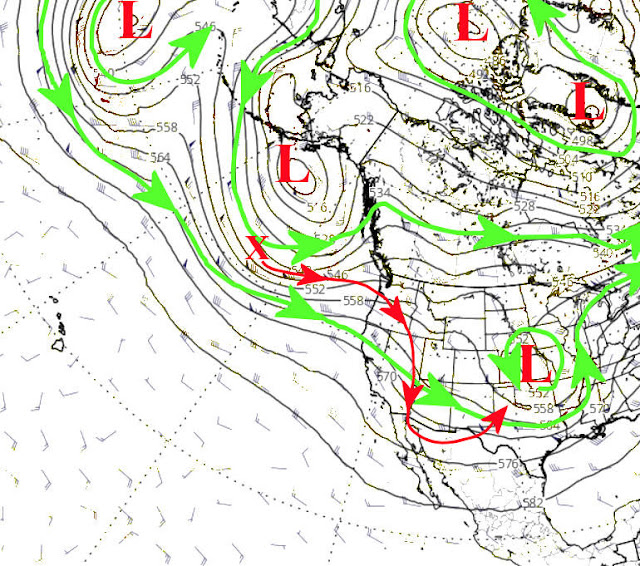
Looking at the jetstream map....
The red X across the Pacific is expected to amplify (technical terms is a anticyclonic wave break), which should allow it to slow down and deepen into the southern Rockies. Since the Gulf of Mexico moisture should be readily available, the precipitation potential across a large part of the central U.S., will be very high. We haven't had this type of opportunity since the widespread rains of mid-October. Keep your fingers crossed. Here is the outlook from the Weather Prediction Center...
I will try and do a brief update early next week.


No comments:
Post a Comment