Friday, March 27, 2015

Update 3/27/15

Unfortunately this is my busiest time of the year and I have limited time to contribute to this blog.

So, very briefly.

Here is the precipitation that has occurred during the past 14 days.  There was some very beneficial moisture for part of the winter wheat areas....


There was also a bit of snow, although the only measureable snow was across northeast Iowa where up to 15 inches was reported.

On the 6th of March I posted a graph showing what had been the temperature departure from normal for Dodge City, and what might happen through April.  That graphic is next...


What actually has occurred and an updated outlook...


Next week I should be able to give an outlook for April....probably on Wednesday.  Stay tuned.

Friday, March 20, 2015

Update 3/20/15

The small weather system that brought widespread precipitation to Colorado, New Mexico, southern Kansas, Oklahoma and Texas on Thursday had rapidly moved out of the area by late in the night.

Unfortunately the program I use to generate maps for rainfall is malfunctioning today, so I can only post the following for the western part of Kansas.

There were good rains that fell into Texas and Oklahoma too!  There is a product available from http://water.weather.gov/ahps/ that shows accumulated precipitation based on rain gauge reports and radar.  However, it appeared that radar output from around the area was over estimating due to what we call bright banding (see an explanation of bright banding by clicking here).  I'm not sure, but I hope the folks making the product will adjust down a little bit.  We could not find any reports of 1.5" to 2.0" that is depicted across southwest Kansas.  (click for a large version)


I won't go into any detail as I'm short on time, but the Climate Prediction Center released the U.S. Seasonal Drought Outlook.  It might be a little optimistic.  I'll come up with a spring precipitation outlook as soon as I get some time. 

Finally, I'm still confident of a major cool down in April with a hard freeze still likely.  I'll update that outlook too sometime next week.

Wednesday, March 18, 2015

Quick update - 03/18/15

Doing presentations on severe weather this time of year takes a lot of time, so I will make this post brief.

Looking at this late evenings (Wednesday) satellite image, there are two features in particular that I want to discuss.  The first is the "X" across northern Mississippi that brought some rain to parts of Kansas and Oklahoma during the day Wednesday.  There other feature, and more important one, is the "L" over southern Arizona.  This Low will move east towards the plains tonight and Thursday.  Widespread rain will develop and overspread Colorado, southern Kansas, New Mexico, much of Oklahoma and Texas.  Snow will fall across the higher terrain of Colorado.


Amounts of precipitation will vary considerably from one location to the next as much of the precipitation will be convective, in other words pockets of heavier rain in the midst of lighter amounts.  One of the computer models suggests the following that could fall by late Thursday morning.


Additional rain will fall across much of the southern part of Kansas and into Texas and Oklahoma during the afternoon Thursday.

More later when I get more time....

Friday, March 13, 2015

Update - March 13, 2015

First, I want to take just a minute and show what the winter temperatures were like across the United States, compared to normal.  Back in early November I did an update to my original winter forecast. That post can be found by clicking here.  My temperature outlook for December-January_February was:


The actual was the following image:

I would say I failed miserably across the northeast but did ok across the remainder of the country.  Do you agree?

The "experts" from the Climate Prediction Center had the following forecast for the same period:


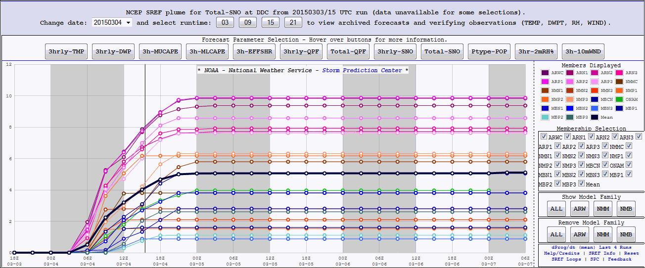
For Dodge City, the following is what it looked like:


We ended up just  a tad above normal for the winter month composite:

Currently:

Wow there is a lot of precipitation falling to the south and east of the central plains!


The cause is a deep upper low over northeast Texas and surface low over southern Arkansas.  But, no snow!  There was light rain and snow across the central and southern Rockies as a moist flow was in place.  Another anomalously deep low over Mexico brought SNOW to  parts of Mexico City!  WOW!


The Outlook

In the previous post done on March 3rd, (see it by clicking here) I briefly mentioned two periods in particular that should be remembered.  The first period I mentioned was from March 21st through 26nd.  The second was April 4th through 24th.

Looking at the patterns established across the northern hemisphere, I think the jet stream and upper level flow should look similar to the following around the equinox of spring:


If this comes to pass, there ought to be a significant cooling period starting around the 21st and it should last several days.  At the same time, there should be at least some precipitation across the high plains.  IF cold air is available, some of this precipitation could be rain.   IF everything comes together just right, there could even be a blizzard with the best chance of that happening across northeast Colorado, northwest Kansas and southwest Nebraska, although other parts of the high plains could be in the mix too.  That is a ways out so details are absolutely impossible to pin point.

After that brief period of cold/possible precipitation, it should warm up dramatically by the 1st of April.  But that will be short lived as the next cold phases gets established.

For the second period of April 4-24, the pattern should look similar to:


If this comes to pass, there will be very cold (April standards) air penetrating into the central plains at times.  Although not every day during this stretch (4th-24th) will see below normal temperatures, the majority of the time it will be colder than normal.  The graph I posted on the 6th still seems very plausible.  You can see that by clicking here.  I still think an April snow or two is likely, especially west of the 100th meridian.


Thursday, March 12, 2015

Spring Weather - for now (updated 3/12/15)

I will update this blog tomorrow (Friday) so check back. 

But I will say for now...these very mild temperatures we're experiencing across the plains were expected (see the previous posts) but unfortunately won't last, and that is actually a good thing. 

Also, in the previous posts I mentioned two periods in particular, March 21-26 and April 4-24.  I'll discuss this in detail in the post I do tomorrow.

Friday, March 6, 2015

Short Update - March 6, 2015

In the last post I showed a snowfall map.  After the event the snow was evident on the visible satellite. Look how narrow that axis of snow was!  WOW! (click for a larger version).


This morning it with nearly all of the snow gone, it appears that there may have a been a few spots in that band down in Seward and Meade counties that may have had six or more inches, based on the melting that occurred yesterday.   Forecasting this narrow of a band with the exact placement is impossible.

In the previous blog on March 3 (click here) I discussed upcoming outlook mentioning the warm period that was about to begin and mentioned some dates for possible snow/rain and a cooling periods.

I put the following graph together giving an outlook of temperatures compared to climatology.  In other words, above or below normal readings. Don't take departures litteraly, but it should at least give you an idea of the trends, and the time scale of such trends. Everything in the box is a forecast and prior to that the departures are the actual temperature departures for Dodge City.  Click for a larger version.


Wednesday, March 4, 2015

Mother Nature throws a sucker punch - March 4, 2015

Weather forecasting can be a real challenge some times.  In the post I did yesterday I briefly discussed what the computer model was forecasting as far as snow is concerned.  That post is here.  The potential snowfall map generated by one of the computer models had a stripe of snow from Elkhart to near Dodge City.  That map can be found here.  The Meteorologist at the Dodge City office where I work was forecasting a swath of 3 to 5 inches based on sound meteorological reasoning and backed up by what forecast models were generating. 

BUT, look at the choices!  The following is a plume of possibilities produced by a bunch of different computer forecasting models, each with slightly different initial conditions.  The possibilities were all over the place! (click for a full size version)

The possibilities for Dodge City generated by the computer at 9 AM Tuesday morning ranged from around an inch to as much as 10 inches!  The median for all of the models was a little over 5 inches. 

But, look what happened!

The axis of snow ended up shifting east by about 30-40 miles.  Such is forecasting when there are 100 quintillion molecules in the atmosphere that make up our weather.  In addition, the storm was still off the coast yesterday morning and was not being sampled by weather balloons.

This also brings me to a point about getting forecast information.  Yesterday all of the TV stations, The Weather Channel, Accuweather, Intellicast, etc. were all over the place with a forecast snow amount.  Why?  Because each probably bases their forecast on just one forecast  model and as you can see from the plume above, the possibilities were (and usually are) all over the place. 

Our forecasters at the local office got it wrong this time (placement), but it certainly is not always the case (based on pure verification, not just some notion that people have).

There will be just a bit more snow today but then the warmup begins (especially during the weekend).  See the previous post from yesterday for that discussion.

Tuesday, March 3, 2015

Brief update - March 3, 2015

Due to other obligations, this will have to be very brief.

The latest satellite image around 9 AM this morning (Tuesday) showed a deep trough and upper low located south of San Diego.  It is in a position to pump copious amounts of Pacific moisture into the southern and central plains, as you can see on the image (whiteness from Mexico into Kansas).  At the same time another Arctic front was surging south.  Normally in these situations this would be a set up for a huge and wet storm for the central plains.  But in this case (and has been the case most of this winter), the low will be undergoing decay as it moves east.  So instead of a deep surface low and what potentially could have been a MAJOR blizzard, the storm will come out in a decaying state.

However, it will still be capable of producing snow across much of the high plains.  Further south and east there will be a major ice storm, or so it appears.


Back to the snow...one of the computer models that we look at offers this solution of possible snow amounts from Tuesday night into early Wednesday afternoon...


Don't take the amounts literally as the weather system is still over water and was not sampled well by the upper balloon network.  The best course of action is to follow your local National Weather Service for the latest thinking and forecast:   www.weather.gov

One of the reasons I wanted to post this morning before I hit the road is to give just a brief outlook for the remainder of March and into April.  Keep in mind, what I'm about to offer is very preliminary and I will be looking deeper into this during the next week or so.

After this shot of cold and snow, the atmosphere will be going back into a "warm" phase.  Since the fall, there have been three distinct "mild/warm" periods and three distinct cold periods.   The atmosphere is heading into the warmer part of the pattern.  Thus, much warmer weather is in store starting Friday and will last into early April.  HOWEVER, there were still be a couple of colder days, but those times of cold won't last too long (day or two).  

As far as precipitation, one period I'm looking at is between March 21 and March 26.  IF, some cold air (not necessarily Arctic) is available, there could be yet another snow this month and most likely during that period.  Historically blizzards are prevalent during the last 10 days of March and this year may not be an exception.  

Following that period of possible storminess, it may get really mild and warm by the first few days of April.  I hope this doesn't bring rapid growth to the wheat. Because?  Because starting around the 4th of April the atmosphere will be going back into the cold phase of the pattern and this may persist until around the 24th of April (with a few above normal days mixed in).  Could there even be an April snow across the plains?  I would bet on it, especially across the higher elevations of the western plains of Colorado and Kansas.

I'll go into more detail and depth as I get a bit more time.