Please see the previous post
here.
Amazing as it may seem, it appears the atmosphere is already starting to transition out of Summer across the northern Hemisphere! There is a lot going on right now. The North American Monsoon (NAM) continues, although farther to the west. Arizona has been getting pounded lately with heavy rain and flash flooding. Rains have diminished across Colorado, and for the most part across much of Kansas. There still have been scattered storms and looking at the map below you can see just where the rains have occurred since August 1st.
The next map shows the percent of normal.
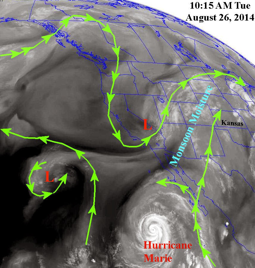
But, even though the NAM continues (albeit farther west) the jet stream winds are increasing across the northern Hemisphere. This is a little ahead of schedule. That could be because of the tropics (land and ocean areas) are continuing to warm while the Arctic, or above 80N is cooler than normal. Looking at the satellite image from Tuesday there are a couple of interesting features across North America.

There is that "low" again across the Great Lakes. Seems as if we've seen that quite a few times this summer. If that repeats again in September....more on that at the end of this post (but don't cheat and skip over the rest of this). The other feature is the low (L) over California. This low will eventually lift out into the Rockies and move east or southeast across the northern and central plains late in the weekend and first of next week. The result will be a cold frontal passage and a dramatic increase in thunderstorms across the plains. Look at the precipitation prediction through early next Wednesday (provided by the Weather Prediction Center)! That is a lot of rain across the northern plains!

You might also notice the generous precipitation signal for the northwest half of Kansas. As we get closer I'm sure this area (and amounts) will be refined. I'm pretty confident that much of northwest Kansas will get quite a bit or rain with lesser confidence into southeast Colorado and the panhandles of OK and TX.
The drought continues! Yes many areas have seen beneficial and sometimes excessive rainfall this summer (but not everyone). However, officially much of the high plains is still in a drought. Why? Because it takes a long time for a major drought to develop, and it takes a long time to get out of one. We're with out a doubt moving in the right direction. But looking at the deficit of precipitation over the past 3 or 4 years there is still a significant one. The following maps show precipitation at Dodge City since October 1, 2013 (considered a water year) and precipitation since October 1, 2010 (combined water years). You will be able to see the deficit I'm talking about...
Officially much of the area is still in a drought (but again it's improving)....
So the outlook through the middle part of next week is for an improving chance for precipitation, especially late in the weekend or early next week. Temperatures should be gradually coming back down after this week. This current week may be about the "hottest" stretch that will occur for the balance of the summer. That may not be good news for the late maturing corn, sorghum and acres of northern cotton . Yes there will be more hot weather but the prospect for a long stretch is very low. In fact, there is some indication that as September approaches there may be quite a few below normal temperature days. That leads me back to the statement earlier in this post about that low over the Great Lakes returning.
Let me first state that weather patterns that become established in the fall will generally repeat at various cycle lengths and amplitudes and continue through the winter, into spring and summer and completely diminish by August or early September. So the pattern that has been in place this year actually started last fall, but is about to "disappear" and re-establish.
If this pattern across the northern Hemisphere can continue and repeat just one more time, then there is a greater than climatological chance of a rather cold airmass invading the U.S. sometime in mid to late September. That would mean a frost or freeze much earlier than normal, especially across the corn belt and perhaps into Kansas. It's not out of the question we could have a hard frost or freeze in Kansas around September 25, give or take 3 or 4 days. However, if that doesn't happen, the new pattern that will be developing will likely set up to be a colder pattern, meaning there could still be an earlier than normal freeze. More on that in a later blog as I attempt to give an outlook for the fall and winter.
Finally, I want to briefly discuss a long range forecast model that is run 4 times a day. It's not precise or extremely accurate but it has shown trends in the weather pattern. When I have an idea of the weather pattern in my mind and if this model supports my notion, then I tend to look at it a little more closely. The model run from yesterday (Aug 19) evenings upper air soundings and global current conditions yielded an extremely wet outlook into early October! It has also been very consistent in showing a wet signal for several days. I was already leaning for above normal precipitation for the early fall - not that I believe this run completely but it's something to consider. The graph below shows predicted accumulation of precipitation for Dodge City through early October. Initial conditions were changed slightly yielding a different outcome providing 5 different solutions or forecasts. The black line is the average of the five different runs. Basically the result is record rainfall between now and October 4th. Do I believe that? No, not really. BUT, it does support my thoughts of above normal precipitation. I guess if somehow the model was completely accurate then there would be major issues of getting fall crops (if they can even mature) out of the fields and get the winter wheat up and growing without getting it washed out of the ground. The same computer forecast model has shown an outlook of below to much below normal temperatures for the fall. I tend to agree with that notion also.

I'll update again next week.
As I mentioned in the last post, if you find this blog useful or helpful please share the link. Again, these are only my thoughts and NOT an official outlook from the NWS or NOAA.