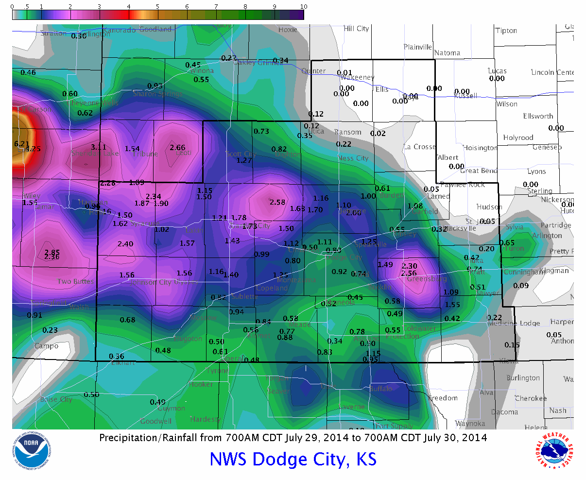
Per the previous post (click here), the widespread rain event had moved out of Colorado and was moving into south central Kansas and Oklahoma early this Wednesday afternoon (7/30/14). The precipitation map shown below is not complete and shows ONLY rainfall up until 700 AM. Much heavier rains fell and I will update a map on the next post. The heaviest rainfall I've seen reported in Kansas has been around 5 inches near Greensburg (around 2.50" as of 7 AM). In general it looks like widespread 1 to 2 inches (some more, some less) across much of the area. North central Kansas, including the Hays area, mostly missed out on this event.
The setup for this episode was "near perfect" as depicted on the following chart showing conditions around midnight last night. I'm a little surprised that there weren't more areas that received over 5 inches, but I guess we can't complain about what we got.
If you're interested, here is the discussion from the heavy precipitation forecaster that generated the map (it's technical - just showing what was being discussed)...
DISCUSSION...THE LEADING EDGE OF MONSOONAL UPPER DYNAMICS AND
MID-LEVEL LOW FROM THE CENTRAL ROCKIES IS BEGINNING TO ARRIVE INTO
THE SOUTH CENTRAL PLAINS EARLY THIS MORNING. IN FACT... RADAR
IMAGERY CLEARLY SHOWS MULTIPLE SMALL SCALE MESO LOWS OVER ERN
CO/WRN KS ADVANCING SOUTH AND EAST OR ALONG A SURFACE BOUNDARY
BECOMING BETTER DEFINED OVER TIME. ADVECTING NORTHWARD TOWARD THIS
BOUNDARY AND MESO LOWS IS INCREASING LOW LEVEL MOISTURE AND AN
ACTIVE NOCTURNAL 850MB LOW LEVEL JET... RESULTING IN POOLING OF
1.5-1.6" PWS WHICH MAY INCREASE TO 2". COMBO WATER AND IR SAT
IMAGERY SHOWS A FLOURISH IN COLD CLOUD TOPS INDICATING RAPID
INTENSIFICATION OVER SERN CO/SWRN KS. THIS APPEARS INVOF OF SLIGHT
250MB UPPER JET COUPLING... LEFT EXIT REGION OF A 50KT STREAK OVER
THE FOUR CORNERS REGION AND 90-110KT RIGHT ENTRANCE REGION STREAK
ALONG THE ACTIVE POLAR FLOW OVER THE CENTRAL PLAINS/MID MS VALLEY.
THIS SHOULD RESULT IN A SORT OF ATMOSPHERIC SQUEEZE PLAY OF HEAVY
RAINFALL. THE GREATEST THREAT APPEARS LIKELY NEAR THE FRONTAL ZONE
FROM SERN CO INTO SWRN KS AND MORE ISOLATED THREAT OVER THE OK/TX
PANHANDLES... WHERE THE GREATEST INSTABILITY EXISTS. EXPECT
POSSIBLE RUNOFF AND PERHAPS MORE LONGER DURATION FLOODING THAN
FLASH VARIETY WITH 2-4" INCHES POSSIBLE AND LOCALLY HIGHER VALUES.
The 1115 AM Wednesday morning satellite map shows the transition of the upper feature that was depicted on the previous post.
As of 1210 PM, the rain was exiting southwest Kansas.
I hope to post again on Friday, time permitting.


No comments:
Post a Comment