Friday, July 29, 2022

Rain event was on schedule!

This will have to be very short as I have very pressing issues...

On June 24th (click here) and again on July 14th I mentioned one of the periods I had picked out to have below normal temperatures and above normal rainfall ("July 25-28 cooler again with a above normal rainfall".).  That was amazingly on target although just a few days early.  Here is the rainfall that has occurred this past 72 hours with the majority falling this past 12 hours ending at 11 AM this Friday, the 29th.


Temperatures have moderated accordingly due to the cloud cover and precipitation that will persist through the weekend.

The heat returns next week but it should be moderated by the amount of rain that has fallen (and will continue to fall this weekend). Humidity will likely be a bit higher with the heat.

The next period I had identified (in June and again earlier this month) is:

August 3-7 Below normal temps and above normal rainfall.

The North American Monsoon will continue and hopefully it will slide over again and influence the high plains weather at that point. I'll do my best to post next week but no guarantees.

Thursday, July 14, 2022

Brief update - this is ugly!

In the previous posting I did a week ago on the 7th (click here to read it), I again listed specific dates that I had first posted on June 24.  The period of July 12-18, I posted "July 12-18 A cooling trend with less hot temperatures.  A better than normal chance for thunderstorms, especially July 14-17"  and ended with "It's going to continue to be a struggle for systems to produce widespread rain events.  The North American Monsoon (NAM) has abated a bit (but still going) and let's hope it can regenerate strongly.".

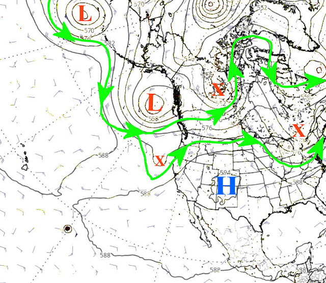
So a little explanation is needed.  The key on precipitation was that last quote, i.e., "it's going to continue to be a struggle for systems to produce widespread rain events".  The cooling did occur, but lasted a whopping 2 days!  That is NOT good!  The 12th and 13th were below normal.  But the remainder of the period is going to be above to much above normal!  That is tied to the expanding upper level high as seen in the upper air map...


That upper high has become very strong, most unfortunately! This will lead to an extended period of very hot temperatures. Those that have missed out on the rains this past 4-6 weeks will suffer the most.

Back to that original post of "A better than normal chance for thunderstorms, especially July 14-17".  The better than normal chance came early with 3 days of thunderstorms on the 11th-13th and because of the expanding upper level high the coverage was dismal.  Here is what fell this past 72 hours....


The North American Monsoon (NAM) has strengthened again but unfortunately has shifted west and too far west to benefit most of the high plains.  But, here is the outlook for precipitation and keep in mind the precip indicated for some of the high plains indicates light amounts...


Hot is here to stay for a while.  In the June posting (and recapped in the July 7th post), I added "July 25-28 cooler again with a above normal rainfall"But keep in mind that it will continue to be a struggle for widespread rainfall.  Essentially there could be 100+ degree temps every day through much of the next two weeks before there is "any" hope of cooling (not that it will be cool by any stretch).   Back in the fall I had made several comments of the similarities to 1956 (the driest year on record at Dodge City).  I'm still holding out on August with some opportunities.  But this might be a run away train at this point so at this time I'm definately not feeling optimistic. 

Thursday, July 7, 2022

Well at least not everyone has been brutally dry!

 In the previous post I did on June 24 (read it here), I put specific periods of opportunities (or not)...

July 4-11  A hotter period with several days, at least, of 100+.  But a few chances of thunderstorms, especially July 7.

July 12-18 A cooling trend with less hot temperatures.  A better than normal chance for thunderstorms, especially July 14-17.

July 25-28 cooler again with a above normal rainfall.

August 3-7 Below normal temps and above normal rainfall.

In between these dates it will likely be HOT and windy!

I was off on the July 7th date by one day as there was pretty good areas of rainfall yesterday (6th).  Even though the following map of rainfall is for a 72 hour period, the majority across the high plains fell yesterday. 


For the past 14 days.....


It's going to continue to be a struggle for systems to produce widespread rain events.  The North American Monsoon (NAM) has abated a bit (but still going) and let's hope it can regenerate strongly.  Colorado and New Mexico have certainly benefited.  Here is the outlook from the Weather Prediction Center through next Thursday (14th)...


I won't be able to update again until at least the 19th...