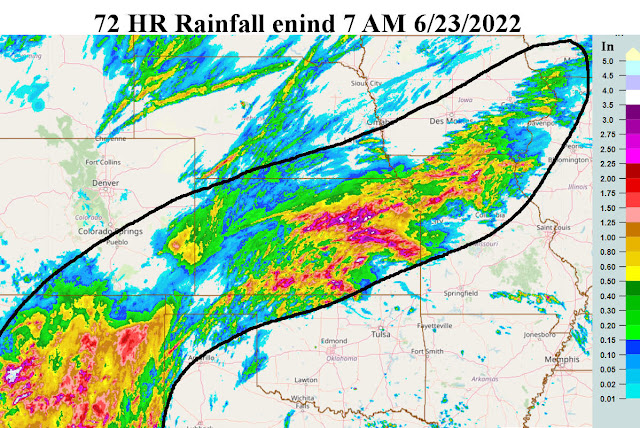
If you had a chance to read the last posting I did on the 15th (read it here) I discussed the glimmer of hope from the North American Monsoon (NAM) during the summer. At the time of the posting there was a NAM on-going and the only hope for precipitation across at least the eastern High Plains would be a shift to the east. That did happen this past 3 or 4 days. However, astonishing (at least to me) is that some locations got completely hosed (in a bad way i.e., NO Rain or very little). Here is a map of the rainfall over a 72 hour period ending yesterday (23rd) morning.
Look how some areas got completely missed! Nine out of 10 times when this shift occurs everyone gets a least a little bit.
Even late yesterday and last night there was additional rain across much of northern Kansas.
For today the heat has returned with a vengeance, but fortunately it will be very short lived. From the upper air map from yesterday (when I started writing), there was a weak upper system over California which had brought scattered thunderstorms out there.
However, that system was weakening and moving northeast. More importantly was the relatively strong upper system moving east out of southwest Canada. That will unleash some anonymously "cold" air that will race into the central U.S. this weekend. With any cloud cover and precipitation, highs may only be in the 60s to low 70s! As far as precipitation with this cooler airmass, much of the influence might be back to the North American Monsoon. As of yesterday, there was still a narrow corridor of moisture coming up from Mexico.
Hopefully that will interact with the cooler air and produce widespread rainfall. The focus will likely be south central and southeast Colorado, New Mexico, and into the panhandles of Texas and Oklahoma. There is a lesser chance into far southwest Kansas but hopefully that area will catch it too. I bet south central Kansas gets it again!
I'm not optimistic for Dodge City though. Geez, my location has missed about the last dozen events.
Here is the outlook from the Weather Prediction Center....
Going into August, I have identified some specific dates/periods. Confidence is not great (given how screwed up this weather pattern is), but at least it's an attempt. Let's see how it shakes out. Again, confidence is not great.
Per the previous post...
June 26-July 3 For the entire period below normal temps (but a couple of hotter days mixed in) and normal to above normal rainfall. Specific date June 30 for another complex of storms.
July 4-11 A hotter period with several days, at least, of 100+. But a few chances of thunderstorms, especially July 7.
July 12-18 A cooling trend with less hot temperatures. A better than normal chance for thunderstorms, especially July 14-17.
July 25-28 cooler again with a above normal rainfall.
August 3-7 Below normal temps and above normal rainfall.
In between these dates it will likely be HOT and windy!
I won't be able to update again until after the 4th. Don't blow anything up, especially your fingers!


No comments:
Post a Comment