Monday, June 28, 2021

Screwed Up Weather Pattern

In the post I did on the 11th (read it by clicking here) I discussed the negative trend I was seeing in precipitation chances.  I was still cautiously optimistic but had concerns about that trend going very dry - and subsequently hot.  Here is the 14 day rainfall ending this morning but in many areas has not been enough to get June to normal or above (mostly below normal) for the high plains.


The headline of this post "Screwed Up Weather Pattern" is no joke.  Look what has happened across the Pacific Northwest with the HUGE and very intense upper high that has developed....


Compare that part of the country to what was going on a little over 2 weeks ago....


That was very unexpected a week out.  I believe that transition to very hot (record heat) in that part of the country is tied directly to the tropics and possibly a Rosby Wave propagation event from a decaying MJO (Madden Julian Oscillation) which has impacted the NW negatively but favorably for parts of the high plains and into the Rockies.   Back to the jet stream map above, the red X over Minnesota with the red dashed line southwest into northern Mexico has helped to bring the clouds, precipitation and cooler weather.  These events above has triggered a favorably environment for tropical activity off the west coast of Mexico (Hurricane Enrique) and has fired up the North American Monsoon which has pumped moisture into the Rockies and west Texas.   This should benefit most of the central and southern high plains with areas of rainfall and continued cooler temperatures through this current week (especially west Texas). Here is the outlook for precipitation from the Weather Prediction Center....


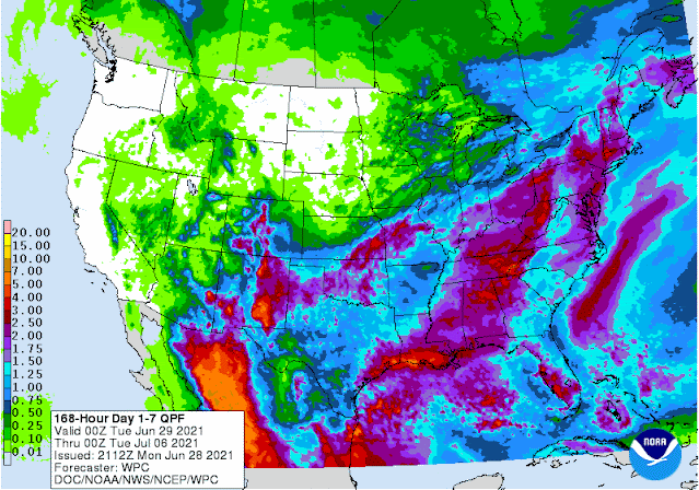
I'm not terribly optimistic with the rain for southwest Kansas but it is possible through period ending Monday July 5.  That is a pretty generous amount of rainfall for Oklahoma (who already got pounded by excessive rainfall this past few days), Texas, New Mexico and the Colorado Rockies.  The rainfall across Oklahoma and Texas could very well have a feedback on July weather.  Even though there will be a window of several days of over 100 the first week of July, the feedback from a "wet" Texas and "wet" Oklahoma and the beginnings of the North American Monsoon may promote July ending up near to below normal on temps (the average for the entire month). That could also favor at least normal rainfall if not above for July.  


Friday, June 11, 2021

I'm Not Liking The Trend

I despise flip flopping on forecasts and outlooks - especially my outlooks.  During the late winter and early spring I was seeing strong signals of the drought expanding and increasing in strength but I wasn't ready to buy in even though in the back of my mind I knew we were due to get extremely dry this year.

By April I then starting to see signals of a wet pattern developing, especially May and I felt very confident that would happen, especially given that the Madden Julian Oscillation (MJO) and the pattern signal of weather systems were seemingly aligned. Indeed it turned wet and wiped out the drought across the majority of the high plains.  Here is the latest map compiled on June 8...


...and the rainfall that fell this past 14 days....


In the posts on May 19 and again on May 28 I was seeing strong signals for normal to above normal rainfall for June.  Long range computer forecast models also supported that idea and with a LOT of consistency from day-to-day which made me feel more confident.  In the previous post on the 28th I was expecting a break in the rainfall with things drying out.  However, I was not expecting the trend to persist like it has.  The surface moisture (humidity/dew point) has been insane!  But because temperatures aloft have been so warm there just has been any real attempt for the atmosphere to convert this moisture into storms.  As of today (Friday) a "cold" front was sweeping through the area dropping the moisture in the air significantly.  The thunderstorms with the system responsible or producing the cold front were WAY northeast!  Here is a look at the jet stream map from this morning...


The jetstream has shifted way north (which is not unusual).  One "bad" signal I've seen during this past week is 1) the warm temperatures aloft, and 2) a ridge aloft developing from western Mexico into the central U.S..   Plus the upper level trough seemingly established off the northwest coast of the U.S..  I hope this breaks a bit during this next week.  If not, I unfortunately will have to do that flip-flop and back off the thought of normal to above normal rainfall for June, which would probably carry into July.  We are due for a dry year.  Dodge City has had 7 years in a row of above normal precipitation.  The greatest streak since 1875 is 3 years in a row.  I'm not ready to throw in the towel but dang I'm having second thoughts. 

So - here is what I hope will happen.  Next week could have increased opportunities for a few thunderstorm complexes, especially overnight.  Another front will be possible by late week.  If there is a void of any storms through the end of next week (say June 18) for the high plains, then I'm afraid what the trend will be going through the remainder of the month and into July.  But as of today (Friday), I'm still cautiously optimistic.  Here is the outlook from the Weather Prediction Center for possible rainfall through 7 AM Friday, the 18th.