Now that the remnants of "Bill" are getting out of the picture, the weather pattern is gradually becoming more early summer-like. Looking at the satellite image, there are several features of importance. Click for a larger version if you like.
Obviously the biggest feature is what is left of what was once Tropical Storm Bill. Along the track of that system there was unfortunately very excessive rainfall and resultant record flooding (on-going). Probably the biggest element it brought to the high plains was an increase in boundary layer moisture. Another feature, that was unexpected by most accounts, was the MCS (Mesoscale Convective System) that brought a late night/early morning round of thunderstorms to Nebraska and northern Kansas this morning. What was left of that MCS has fired into additional thunderstorms across the northern Texas panhandle this Thursday afternoon.
The other important feature is the "H" across southern California. This is the beginnings of a ridge of high pressure in the upper atmosphere that will build into the plains for the balance of this week and into much of next week. A forecast challenge that will exist is just how hot the temperatures will get above the surface (we call this the EML - Elevated Mixed Layer). If the air gets too warm aloft, it will help suppress thunderstorm activity across the plains. This is actually the most likely scenario. That is, for the most part, much drier weather can be expected into the latter part of next week. Plus, with increasing daytime temperatures, some wind and in general a little less humidity, the opportunity for ripening winter wheat should commence. There could still be scattered storms around - but the coverage should be at a minimum
Here is the outlook by WPC - the Weather Prediction Center - for the next 7 days.
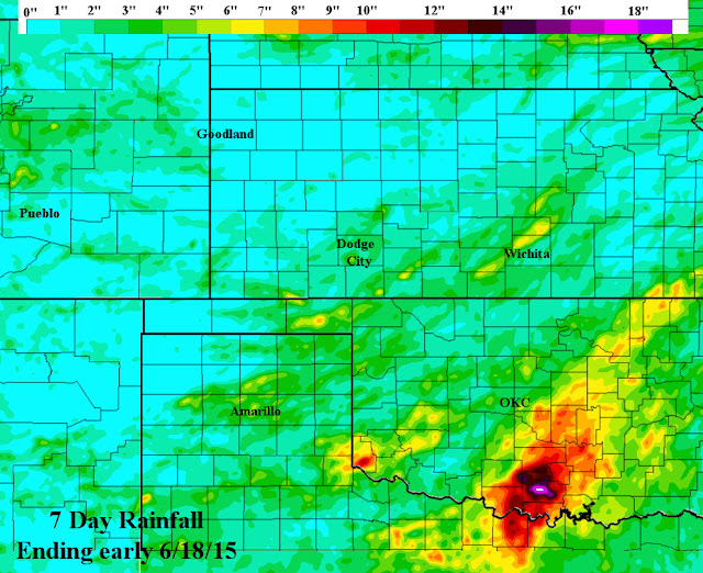
Even though the weather may become more favorable for grain harvest, haying operations or other field work, there is likely still issues with wet or muddy fields. I can only imagine this as look at the rainfall for the past 7 days. (click for a larger version).
It amazes me the amount of rain that fell in parts of Oklahoma the past week. Nearly 20 inches in some locations! Parts of Central Oklahoma have had 40 to 45 inches of moisture since the first of the year!
Looking ahead
I'm afraid in a week to 10 days there may be several cold fronts enter the picture. Not only will they bring cooler temperatures but also an increase in chances for storms and higher humidity. I can see the pattern becoming more favorable for late afternoon through overnight thunderstorm complexes moving out of the front range areas of the Rockies toward the last 3 or 4 days of the month. July still looks wetter than average too, at least at this point. Take advantage of favorable weather while you can.


No comments:
Post a Comment