
Along with the "cold" temperatures there was widespread rain and drizzle but unfortunately (for some) the amounts were rather disappointing. The heaviest rains fell from Jetmore to southwest Barber county and also across the area from Elkhart to northwest of Liberal. In these areas amounts of 1 to 3 inches were common with several 4 inch amounts reported. But, there were also areas that received only a small amount of rainfall.

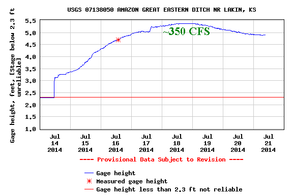
In the post last week I had mentioned the heavy rains that had fallen across the foothills of Colorado and adjacent plains of southeast Colorado that produced flash flooding. There was a large volume of water flowing down the Arkansas River, both above and below John Martin Reservoir. Additional heavy rains fell during the remainder of the week and it appeared that water might actually make it to at least Garden City. Hmmm. It is SO apparent that irrigation has a dramatic impact on water in the river. All or almost all the heavy flow of water was diverted into the irrigation ditch system (and into privately owned Lake McKinney in Kearny County). Water flowing down the Ark had been diverted into four irrigation canals; 1) Frontier Ditch near Coolidge; 2) Amazon Great Eastern Ditch near Lakin; 3) Southside Ditch near Lakin; and 4) Farmers Ditch near Deerfield. Look at the water flowing through the Amazaon Great Eastern Ditch! WOW!
Off the soapbox...
The additional rains last week have helped a little in terms of the drought. Much of Kansas and the central/southern plains still are in an extreme or exceptional drought due to the length of the dry spell before the rains.


At Dodge City we're doing pretty good since October 1, 2013.
 But as mentioned in the previous post, there is still a huge deficit since the beginning of Water Year 2010. |

Outlook for this week and into August
In a previous post I had mentioned the North American Monsoon (it's not a "real" monsoon). The pattern is still set up just fine with copious moisture moving north out of the Mexico into New Mexico and Colorado. The only problem? Temperatures in the plume are unusually warm which is now preventing widespread thunderstorms!. The satellite image below shows the flow of moisture.

Typically in this pattern there would be numerous afternoon thunderstorms across the Rockies (as there was last week). Still, there should be convection, just not quite as widespread as normal and some of this will drift into Kansas.
Our attention is now drawn to the upper low over California (the L) and the jet stream across the Pacific Northwest. In addition (not on this map) there were several typhoons across the western Pacific. The typhoons will force the jet stream to buckle and will take the California low north, east and then southeast into the midwest towards the end of the week. The result will be another cold front into the plains, but not as cold as last week. The upshot will be cooler (not colder) temperatures and an increase in opportunities for thunderstorms by next weekend (July 26-27).
So, the weather pattern is NOT expected to become stagnant with day-after-day of 100+ degree weather. Rather, there should still be periodic fronts (some stronger than others) for the balance of July and into August. With these fronts there should be a continued chance for thunderstorms on occasion although nothing widespread is on the immediate horizon. Hopefully those unlucky ones that have not benefited from this active summer will finally get a rain or two.
Looking deeper into August there are some signals/signs that the month may not be too hot - or dry! One of the long range computer models actually is forecasting MUCH below normal temperatures across not only Kansas but also across the Corn Belt. I know that much of the corn was planted late this past spring and we need to start thinking about if the corn in that area will be able to mature before the first freeze. Something to think about and watch.
August can be a real tricky month to forecast for as the jet stream is typically at it's weakest across the northern hemisphere. Any notable and repeating pattern usually dies out completely during August so we have nothing to go on other than looking for subtle changes in the flow aloft and at the surface. If I had to make a guess I would go for near to slightly below normal temperatures and near normal rainfall. Again there will be those that receive less than normal rain and those that get quite a bit. There should still be hot stretches but not L O N G stretches.
BTW, we CANNOT make an assumption about early freezes and winter weather based on what happened during the summer. The pattern will re-establish itself by late September or early October as the flow aloft increases due to the changing of the seasons. At that time we can get an idea on what is possibly in store. I will say, however, that looking strictly at records that the following winters after a record cold spell in July that most have tended to be dry and cold. Caution: I'm not saying that will be the case this winter. Give me a month or more to start looking at that.
Lately temperatures across the Arctic have been below normal and the phase of the Arctic Oscillation (AO) has tended to neutral and is expected to go to slightly above. But, if conditions continue as such across the Arctic and the phase of the AO goes strongly negative then I would expect a VERY sharp cool down into the Midwest and possibly central plains. I'll keep an eye on that.


I hope to update again around July 30.
No comments:
Post a Comment