
That helped some on the expanding drought (eastern edge) for some but unfortunately not all. Unfortunately for some there was excessive rainfall!
Here is the latest drought map.

Attention turns to this nasty change in the weather coming up. In the previous post, I was NOT anticipating a killing freeze other than the northern plains and upper midwest. There simply were NO signals as of September 28 that there would be a pattern shift to allow for what is about to happen.
Long time readers of this blog have heard this before. The transition from Summer to Fall across the northern Hemisphere is a very tricky time to make long range weather predictions. The westerlies (winds aloft) across the northern hemisphere start to increase in amplitude and at some point in early October start a wave harmonic with emphasis on locations of troughs and ridges changing from year-to-year. These ridges and troughs are likely set based on atmospheric forcing that also changes every year. I can only speculate on which area (oceans, landmass, tropics, etc.) will provide the greatest forcing this time around. Once this wave harmonic has formed, it then propagates across the globe at various speeds. This continues for about 10 1/2 to 11 1/2 months.
So, back to the September 28 posting where there were NO indications of this unseasonably cold that is happening or about to happen. On the 28th, the "new" wave harmonic had not formed. But now, we're in the very early stages of this new harmonic (pattern). There was already anonymously cold air across Canada, just waiting for an excuse to be dislodged south. That excuse appears to be a super typhoon out in the western Pacific. Here is the latest satellite image showing that system (the bright white with a dark hole - the eye)....

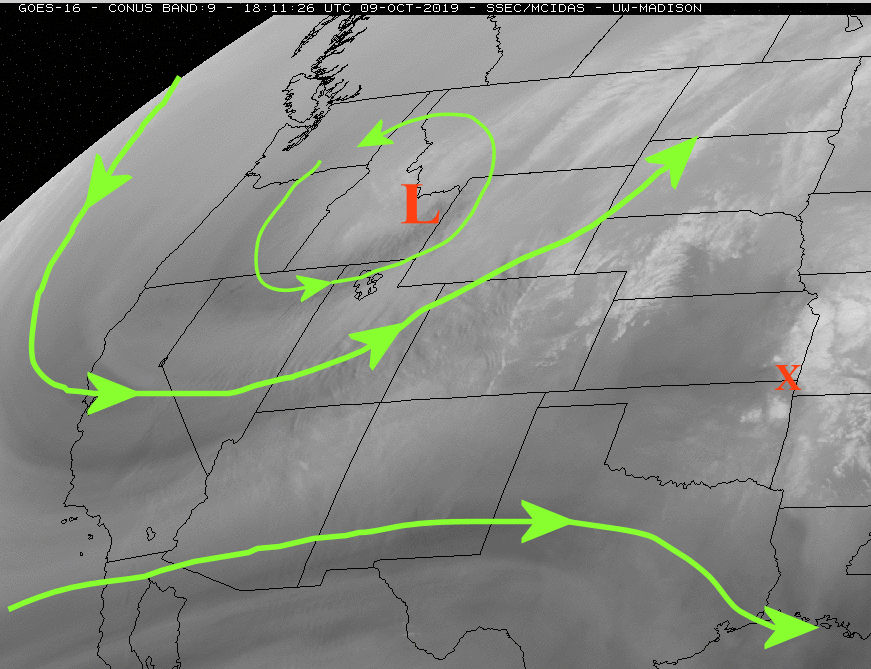
This system was extremely strong and had influenced the jetstream leading to downstream amplification which ultimately was dislodging the cold air. Farther downstream, the amplification was unseasonably strong across the northern Rockies with the center indicated by the red L on the following satellite....
BTW, this location of the upper trough and the amplitude of the cold air that built up just "may" be one part of the pattern we see this winter and next spring! More on that in later posts.
The red X across southeast Kansas was a weak system on the southern periphery of the western U.S. dip in the winds aloft. It brought scattered thunderstorms to much of the southeastern 1/2 of Kansas this Wednesday morning.
So back to this cold air. At Noon today (Wednesday) there was quite a contrast across the central U.S....

The front separating this contrast was racing south and will overspread much of the high plains throughout Thursday. The location of the associated surface low and upper system will favor the Rockies and into the northern Plains as far as precipitation goes. The amount of snowfall, especially across parts of the western Corn Belt may be record breaking for this time of year. For the high plains, we will be mostly on the dry side although there could be just a little bit of rain or even snow (insignificant). The cold, however, will be record breaking for this early in the year. Here are possible low temperatures expected by Friday morning....

Keep in mind, these temperatures will also be associated with a lot of wind so the freezing aspect will be much more extreme than normally experienced for fall systems.
The cold will linger into Saturday but then moderating temperatures can be expected into next week.
Remember, early fall is a tricky time to make a long range outlook. Having said that, some of the signals across the western Pacific point to a possible increase in opportunities for more precipitation starting late next week. No computer models are indicating much of anything for the high plains through the 25th of this month. But, I will be highly surprised if we don't go into a period of increased thunderstorm activity and mild/warm temperatures by the 18th. The main issue I see is getting Gulf moisture back this far if there are frequent fronts. Having said that, the best opportunities will be east of the 100th meridian (not high plains but central and eastern plains).
No comments:
Post a Comment