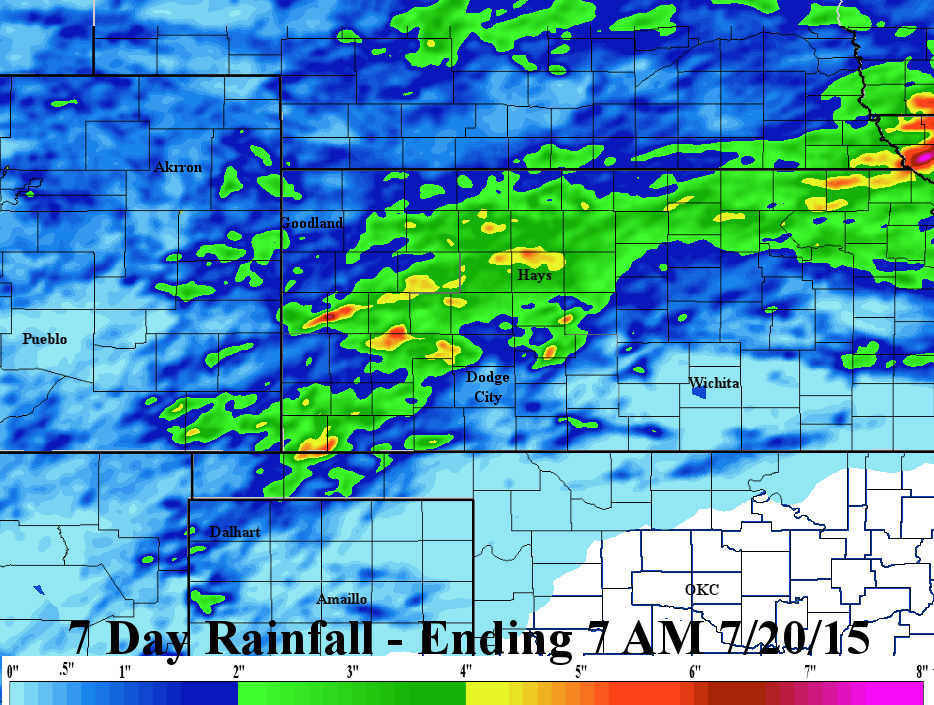
Over the last 7 days, there was copious amounts of rainfall at some locations. In general, there was a large area of 2 to 4 inches during that period. However, the southern part of the precipitation was very light or none at all. So it goes during the summer!
Click for a larger map.
In the post I did Friday (click here) I discussed the remnants of what was one Hurricane Dolores. The left overs from that system brought unusually heavy rains to parts of southern California and for July this is nearly off the charts! I had mentioned that the added moisture or even the remnants could impact the plains this week. As of today (Monday), it appears that the actual remnants will be moving across the central plains on Tuesday into Wednesday. Combined with an old frontal boundary (or outflow boundary from Sunday nights convection), there should be rather widespread thunderstorms during the period it moves across. Rainfall in some spots should be very generous. However, there will still be some "unlucky" ones with much less.
The majority of the rainfall expected in the next 7 days, as depicted by the WPC, will fall tomorrow and Wednesday.
Click for larger version.
Some spots in the heaviest axis will be 3 or 4 inches, at least. With the clouds and moisture, temperatures will be moderated significantly (mid 70s to low 80s) where the precipitation persists on Tuesday and Wednesday.
The satellite image from this afternoon shows several disturbances that will impact the central plains.

The "X" off the California coast is what was the center of Hurricane Dolores. But the"X" over Las Vegas is other remnants too. This is headed towards the high plains.
In the previous post on Friday I also mentioned a "heat wave" that could develop later this week and stretch into the following week. Well, now with the added precipitation, I'm hopeful that daytime temperatures will be tempered downward somewhat as there will be a lot of latent heat released from evaporation. So, even though temperatures will get toasty, I'm now thinking not quite as hot as it could have been. In other words, typical summer temperatures.
But, there should be a drying trend in terms of thunderstorm coverage as an upper level ridge strengthens. The exception will be the center of the corn belt and also across the Rockies were the North American Monsoon will continue.
No comments:
Post a Comment