In that blog post I also discussed THE referenced graphic of the epic snowstorm that could occur on the 28th. Since that time this same computer model has forecast absolutely nothing, rain, sleet and snow and anywhere from east central OK, central Texas to Nebraska. It's a common occurrence for this to happen. IF that particular model run would verify, it would do so by only dumb luck. This person on Facebook that posted this model output has since shown almost every other output solution., except for the ones that showed nothing. Remember, these forecast models will sometimes fail within the first 12 hours, let along 324 hours in the future! But, sometimes (rarely) they can be close!
Also in that posting I did, you may recall that I said "ironically there could very well be a storm between Christmas and the last few days of December". The pattern and current atmospheric forcing would lead me to believe the possibility. That still does appear to be the case!
First, leading up to this "STORM".
In this afternoons satellite image, there were two features that may impact part of the plains states.

The first feature is the X1 over Washington...that feature is going to move rapidly south and east and could bring a few sprinkles to Kansas and Nebraska on Tuesday and snow to the northern Plains. The second feature, the X2, will dive into the plains by Wednesday and will bring additional light precipitation (mostly sprinkles) to the high plains but will become a strong storm for the midwest (liquid) and severe thunderstorms across the lower Mississippi Valley, including the possibility of tornadoes.
Then attention turns to the STORM. So, why did I say ironically there could be a storm after Christmas?
First, the cycling pattern supports the jetstream diving into the Rockies at about that time (I've talked about these cycling patterns numerous times in this blog). Second, the ocean temperatures and the location of tropical convection (forcing) also supports this diving, or digging, jetstream.
The Madden Julian Oscillation (MJO) supports this eventual transition. The image below is what is called an MJO composite (there are different phases spaces that can be calculated)...

The transition from phase space 5 into phase space 6 for this time of year supports a trough of low pressure aloft located across the western U.S..
Looking at the satellite image from this afternoon...

The MJO was located across the Maritime Continents. There was already a coherent response in the from of mirrored upper level flow (both northern and southern hemispheres). The northern hemisphere flow was enhancing the "East Asian Jetstream" (the green line coming off eastern Asia). The possible storm that could occur after Christmas was nothing more than a disturbed area in the flow aloft, marked by the X.
So what this means, is that this "X" certainly has the support from tropical forcing and extended East Asian Jetstream to "dig" into the western U.S. or Rockies by the weekend. But, since this is still many days away, there is just no way to know exactly where the system will end up and how strong it will be. But everything does support a vigorous storm, anywhere from south Texas to Nebraska.
The Global Forecast System ensemble forecast from this morning shows many possibilities by late Sunday. Remember from my previous post, an ensemble forecast is attained by the computer model running with slightly different initial conditions.
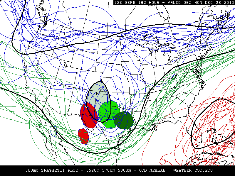
What the above map shows is that there is still a huge range of possibilities for the position of the storm. The black outlined light-green/grayed-in circle shows the composite (or average). As we get closer to the event, I will have more confidence on what to go with. The gulf of Mexico is very moist and warm and this system will have copious moisture to work with. I'm very, very confident of flooding rains will occur across parts of eastern Texas, Oklahoma and the lower Mississippi Valley. Depending on the track and evolution, heavy and flooding rains "could" also occur in Kansas and then the frozen stuff that will fall in the cold sector of the storm as the potential to be heavy. Again, I'll get a little more specific as time approaches (I'll try and update later Wednesday or early Christmas Eve). Follow weather.gov for updates (some offices are starting to talk about it).
No comments:
Post a Comment