Friday, May 20, 2016

Update 05/20/2016 - Active period coming up

In the previous post I did last Friday (read it by clicking here), I discussed the wet and cool period that was expected.   The following map shows the estimated rainfall across the region...(click for a larger map).


There was very generous amounts across a large area.  But there were also areas that did not receive much at all, which is very disappointing (and I hope it's not a trend).

In the last post I also discussed that soil temperatures would likely tumble.  I only have Dodge City as an example, but indeed there was quite a drop.  At 2 inches the temperature varies quite a bit from day-to-day anyway.  But, there was a decrease from a high of 70 degrees to a low of 52.  At the 4 inch depth, the variance went from 67 degrees down to 53.  Also, because of the cloud cover, cold airmass and some precipitation recently, the average temperature during the past 23 days has also plummeted.  At the Dodge City airport, the period from April 27th through May 19th tied as the third coldest  on record.  That is pretty significant.  (click for a large version)


 Now attention turns to a developing May pattern that will likely produce an extended period of daily severe weather.  Initially this weekend the threat will be limited in width (but stretch quite a bit north and south - see the graphic).

For Saturday (approximate location of the greatest threat)


For Sunday (approximate location of the greatest threat)

Monday through Friday the threat will shift east quite a bit.  As far as rainfall, the western fringes will have to battle dry air coming off the higher elevations.  Thus, the following graphic from WPC....

 
If this rainfall prediction for the next week verifies, there will be parts of the far western high plains that will not have received much rainfall for May.  Thus, we might start showing signs of drying out. I still am optimistic for at least June and into July, as far as rainfall possibilities and limiting the scorching windy heat.  More on that later....

Friday, May 13, 2016

Update 05/13/16

In the previous post I did on April 29 (read it here), much of the plains had just experienced one of the wettest Aprils on record (some locations smashed the previous record).  I gave insight to what I was expecting deep into the summer months (June and July in particular) and wrapping up in August.  If you have not read that post, please do so.

I haven't posted since then because of an extremely busy schedule.  Has my thinking changed from the previous post?  No, at least there is nothing popping up that would change my mind at this point.

Since May 1, there has been quite a bit of rain, especially across the corn belt.  The areas that had record April rainfall in Kansas have been missing out (and thus drying out a bit).  But, that is about to change again...(click for a full scale graphic)


In the near-future, there was a big gyrating upper low across southeast Canada and the flow aloft is such that much below normal temperatures will invade much of the midwest and plains.  Freezing temperatures are expected across much of the northern plains and upper midwest.  I have no idea how the corn planting/emergence has progressed up there, but I guess there could be some issues.

Closer to the high plains, it looks like a "cold" and wet period (overall late in the weekend and into the middle part of next week).  I would bet that soil temperatures (at least the top four inches) will plummet at least 10 degrees next week (and 15-20 degrees in the top 2 inches).  We keep track at the NWS office in Dodge City, so I'll try and remember to post what happens in the next blog post.

Here is the potential for precipitation through the end of next week....


Also, if you haven't seen it...the latest drought monitor....


I hope to be able to update again later next week when I find a few minutes.

Friday, April 29, 2016

Update 04/29/16

In the previous post I did on the 25th (read it here) I talked about the changes to the jetstream flow across the western U.S. that was expected to shift precipitation back into the plains.  That certainly has happened with copious amounts of rain last night and today (Friday) and with the potential for heavy front range and mountain snows.  At the Dodge City airport we set a record for April with 7.90" as of noon today, with a potential for a little more into Saturday morning.  I saw several reports over 3 inches from this system.  If I get a chance I might update with a precipitation map.

Looking at the afternoon satellite image...


The upper system (X1) that brought the heavy rain overnight and this morning was located near Garden City and was lifting rapidly north and northeast.  The main system (the L over northern New Mexico) was wrapping heavy snow into Colorado (rain at lower elevations) and was slowly moving east.  But, this system was also beginning to weaken slowly as a lot of the energy will be transferred to X1.  But before doing so, there should be large amounts of precipitation across Colorado, northern Kansas and into Nebraska.

Another system (X2) was dropping south-southeast out west and it could be strong enough to bring another round of precipitation to the Rockies and western plains late Sunday into Monday.  The weather should then settle down for the remainder of next week, but temperatures will remain near or below normal.   Yet another change in the jet stream could setup an active period starting late next weekend or the following week (May 8-13). 

If you go all the way back to the posts I did late last summer and during the fall, I discussed similarities in the indices of El Nino and the Pacific Decadal Oscillation.  It is one of the reasons I wasn't sold on the dire predictions of death and destruction from this years so called Godzilla of all El Ninos.  Go back and take the time to read those posts if you can.  Anyway, I suspected that our weather across the plains could be similar to the 57/58 El Nino event.  So far, that has basically followed suite (with a few differences).  

The following map shows a composite of the precipitation anomaly for June and July 1958.  Look at the above normal precipitation anomaly for that period!


Temperatures were influenced by the rainfall and no doubt lush vegetation.  The following map shows the temperature departure for the same period:


Based on the pattern that has existed since last fall and taking a hunch that this summer may be similar to 1958, the following prediction made by the Climate Prediction Center may not be far off!


What I'm saying is that I'm leaning towards normal to above normal precipitation from Kansas into the Corn Belt, for June and July combined.  Yes, there will be dry stretches though.  The southern plains may begin to start a drying trend but may still get some timely rains.  As far as temperatures, perhaps normal to below in the same area (except from Amarillo south where it will likely be warming up quite a bit).  The bad news is that by the end of the summer (August) will most likely be drying out and heating up, even into the corn belt.  Hopefully all of that will be past corn pollination.


Monday, April 25, 2016

Short update 04/25/16

In the previous post I did on the 20th (read it here) I briefly mentioned that the end of the weekend and the first of the week there could be severe weather as a strong Pacific storm dropped into the west.  Indeed, there was severe weather on Sunday with lots of BIG hail and a couple of short lived tornadoes across parts of Nebraska, north central and northeast Kansas. A more significant outbreak of severe weather is expected tomorrow (Tuesday).  But good news for the high plains, the severe activity will be east again.

I unfortunately am swamped with work and life in general so will have to make this short.  Looking at the satellite image from this morning... 


The "L" over Nevada and Utah is the center of the upper level trough across the west.  The jet stream rotating around this system will impact the central part of the U.S. late tonight into early Wednesday.  But, the good news is that the trough will move only slowly east so that another wave of energy will develop and move out into the central part of the U.S. towards the weekend.  This system should be more favorable to bring precipitation farther west.  I don't have time to analyze that potential but can only provide the 7 day outlook for precipitation provided by the Weather Prediction Center.  IF this occurs, some areas of western Kansas will have had record rainfall for April (for instance, Dodge City needs only 0.46" to set the record).  

More on this as I get time, hopefully by the end of the week.


Wednesday, April 20, 2016

Update 4/20/16

Read the previous post I did on the 15th here.  As advertised, the "bowling ball" brought copious amounts of rain to much of the plains, BUT as advertised there will still some that did not get the heavier rains.  In fact, some locations got only 1/4 to 1/2 of an inch!  Here is a map of estimated precipitation over the past 7 days...(click for a bigger version)


What is striking is the amount of rain that fell near Elkhart in the extreme southwest corner of Kansas.  One observer has had almost 8 inches!  That is over half of what normally falls in an entire year!

But also on the map, you will see the areas that generally missed out, especially across parts of the southern plains and also around the eastern Oklahoma Panhandle.  There will be additional showers and storms later today and into Thursday (20th - 21st) that may catch a few of those spots.

Looking at the satellite image from late morning....


There is still an MJO impacting the flow in the jetstream across the higher latitudes.  There is a strong system across the northern Pacific that should impact the plains by the end of the weekend and first of the week.  Unfortunately the setup by then may be conducive to severe weather (and additional precipitation).  Due to time constraints I cannot go into much detail.  But here is the possible precipitation during the next 7 days courtesy of the Weather Prediction Center.


I may have an opportunity to update this blog by next Monday or Tuesday.

Friday, April 15, 2016

Big Bowling Ball - Updated 4/15/16


In the previous post I did on the 12th (read it here), I discussed the upcoming weather system.  So far it's developing as advertised.  BUT (yep, there is that "but" word) there is still a lot of uncertainty of amounts and where the heavier rain will fall!  In the previous post, this is what I said 

"Will all areas receive this much?  NO!  But, it is possible many locations will.  In general I would feel confident of widespread 1 to 2 inches."

 Let me start with the afternoon satellite image....

 
The upper system is developing as advertised but it is in the initial stages of development.  The X1 on the map near Las Vegas, NV should become the dominant system as it deepens and breaks off from the jet stream across Canada.  The X2 appears to be dropping south and should merge with the other system to form into an intense upper level low.  Gulf of Mexico moisture is somewhat lacking at the moment because of the departing system that over eastern Arkansas.  But, gulf moisture should become plentiful.

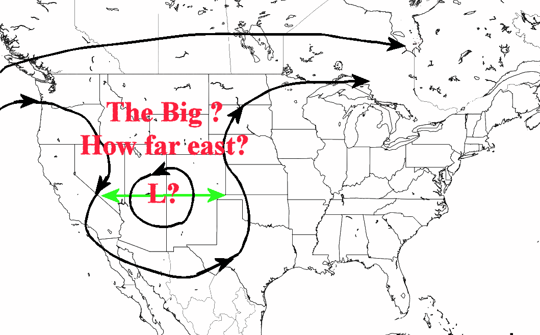
Computer models have been ALL over the place as far as location of heavier rain.  One run it's near the Colorado/Kansas border, then the next over central Kansas (for our local area).  One issue will be just how far east or west the upper low gets. This will have an impact of where heavier rain sets up.  The location is just simply unknown and impossible to predict at this point.


Then, there will be mesoscale processes (small scale features) that will  also impact locations of heavier rain.  There is a very high confidence that excessive rainfall will fall, but the exact location is just impossible to predict because of the large scale and mesoscale processes.  If I pick just one location, let's say Dodge City for instance, the actual possibilities of the amount of rain through Tuesday would range from as little as 0.50" to as much as 6 inches.  That is a HUGE spread but it's the honest truth and just the way it is!  I'll go back to my original statement from the post on the 12th.  I'd feel confident of widespread 1 to 2 inches across much of the plains.

Here is the latest outlook from the Weather Prediction Center (again, don't count on the amounts at any one location, just consider this to be a high end possibility) through the end of next week.  Adjustments will be made with the small scale interactions....

Tuesday, April 12, 2016

It is a start - updated 04/12/2016

In the previous post I did on the 8th (read it here) my optimism for precipitation had increased only slightly.  I've been waiting for a change in the hemispheric weather pattern, similar to what occurred during the fall.  Recently the blocking ridge off the southwest U.S. coast had broken down enough to allow a system to move through and which eventually impacted parts of the high plains and Oklahoma/Texas.  The rainfall during the past two days was generous in some locations, while others missed out completely or received very little.  The map follows (click for a larger version):

 
But, this "might" be a start!  I will feel a whole lot better if the potential for late week and weekend pans out.

Looking at this mornings satellite image:

There is an active MJO (Madden Julian Oscillation) that has enhanced the southern branch of the westerlies (sub-tropical jetstream).  Also, the MJO appears to be influencing the northern branch (jetstream) in that a full latitude ridge may be developing (the dashed blue line).  If this is the case, then the upper level systems across the north Pacific "should" be able to amplify downstream into the western U.S..  At the same time there is apparent blocking across the Atlantic.  IF (a big if but I'm gaining a great deal of confidence) the two aforementioned details come together, then there should be a deep upper system develop across the western U.S. and Rockies by the end of the week (similar to what occurred during the fall).  Gulf of Mexico moisture will become plentiful by then so any system moving into the plains should have no problem in generating badly needed rainfall.  Like I said, I am gaining confidence in this evolution.  The Weather Prediction Center has the following outlook for accumulated moisture through next Monday:


IF everything comes together (the stars align sorta speak), then I have no doubt there will be a lot of rainfall across this area (and perhaps heavy snow in the foothills of the Rockies).  Will all areas receive this much?  NO!  But, it is possible many locations will.  In general I would feel confident of widespread 1 to 2 inches, which will certainly go a long, long way in helping the winter wheat.

I'll update later this week.