Monday, June 28, 2021

Screwed Up Weather Pattern

In the post I did on the 11th (read it by clicking here) I discussed the negative trend I was seeing in precipitation chances.  I was still cautiously optimistic but had concerns about that trend going very dry - and subsequently hot.  Here is the 14 day rainfall ending this morning but in many areas has not been enough to get June to normal or above (mostly below normal) for the high plains.


The headline of this post "Screwed Up Weather Pattern" is no joke.  Look what has happened across the Pacific Northwest with the HUGE and very intense upper high that has developed....


Compare that part of the country to what was going on a little over 2 weeks ago....


That was very unexpected a week out.  I believe that transition to very hot (record heat) in that part of the country is tied directly to the tropics and possibly a Rosby Wave propagation event from a decaying MJO (Madden Julian Oscillation) which has impacted the NW negatively but favorably for parts of the high plains and into the Rockies.   Back to the jet stream map above, the red X over Minnesota with the red dashed line southwest into northern Mexico has helped to bring the clouds, precipitation and cooler weather.  These events above has triggered a favorably environment for tropical activity off the west coast of Mexico (Hurricane Enrique) and has fired up the North American Monsoon which has pumped moisture into the Rockies and west Texas.   This should benefit most of the central and southern high plains with areas of rainfall and continued cooler temperatures through this current week (especially west Texas). Here is the outlook for precipitation from the Weather Prediction Center....
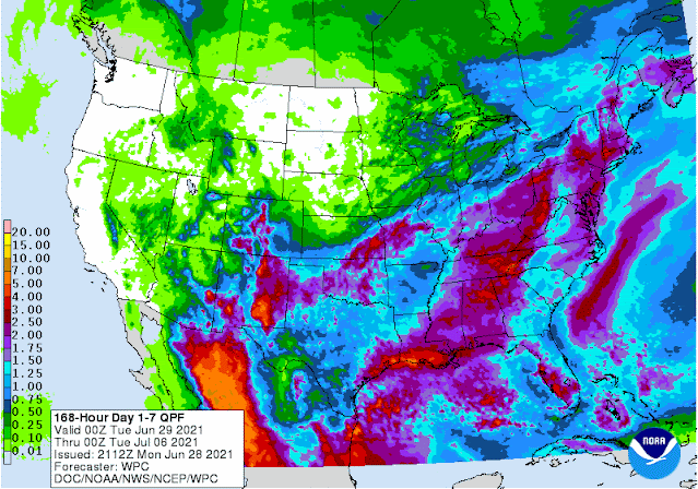

I'm not terribly optimistic with the rain for southwest Kansas but it is possible through period ending Monday July 5.  That is a pretty generous amount of rainfall for Oklahoma (who already got pounded by excessive rainfall this past few days), Texas, New Mexico and the Colorado Rockies.  The rainfall across Oklahoma and Texas could very well have a feedback on July weather.  Even though there will be a window of several days of over 100 the first week of July, the feedback from a "wet" Texas and "wet" Oklahoma and the beginnings of the North American Monsoon may promote July ending up near to below normal on temps (the average for the entire month). That could also favor at least normal rainfall if not above for July.  


Friday, June 11, 2021

I'm Not Liking The Trend

I despise flip flopping on forecasts and outlooks - especially my outlooks.  During the late winter and early spring I was seeing strong signals of the drought expanding and increasing in strength but I wasn't ready to buy in even though in the back of my mind I knew we were due to get extremely dry this year.

By April I then starting to see signals of a wet pattern developing, especially May and I felt very confident that would happen, especially given that the Madden Julian Oscillation (MJO) and the pattern signal of weather systems were seemingly aligned. Indeed it turned wet and wiped out the drought across the majority of the high plains.  Here is the latest map compiled on June 8...


...and the rainfall that fell this past 14 days....


In the posts on May 19 and again on May 28 I was seeing strong signals for normal to above normal rainfall for June.  Long range computer forecast models also supported that idea and with a LOT of consistency from day-to-day which made me feel more confident.  In the previous post on the 28th I was expecting a break in the rainfall with things drying out.  However, I was not expecting the trend to persist like it has.  The surface moisture (humidity/dew point) has been insane!  But because temperatures aloft have been so warm there just has been any real attempt for the atmosphere to convert this moisture into storms.  As of today (Friday) a "cold" front was sweeping through the area dropping the moisture in the air significantly.  The thunderstorms with the system responsible or producing the cold front were WAY northeast!  Here is a look at the jet stream map from this morning...


The jetstream has shifted way north (which is not unusual).  One "bad" signal I've seen during this past week is 1) the warm temperatures aloft, and 2) a ridge aloft developing from western Mexico into the central U.S..   Plus the upper level trough seemingly established off the northwest coast of the U.S..  I hope this breaks a bit during this next week.  If not, I unfortunately will have to do that flip-flop and back off the thought of normal to above normal rainfall for June, which would probably carry into July.  We are due for a dry year.  Dodge City has had 7 years in a row of above normal precipitation.  The greatest streak since 1875 is 3 years in a row.  I'm not ready to throw in the towel but dang I'm having second thoughts. 

So - here is what I hope will happen.  Next week could have increased opportunities for a few thunderstorm complexes, especially overnight.  Another front will be possible by late week.  If there is a void of any storms through the end of next week (say June 18) for the high plains, then I'm afraid what the trend will be going through the remainder of the month and into July.  But as of today (Friday), I'm still cautiously optimistic.  Here is the outlook from the Weather Prediction Center for possible rainfall through 7 AM Friday, the 18th.


Friday, May 28, 2021

More Wet May Weather in Store

 In the previous post I did on the 19th (click here) I discussed another period of precipitation starting as early as the 21st but with increasing likelihood for severe weather.  Unfortunately the severe part became a reality.  As far as rainfall, here is what fell this past 7 days ending this morning (28th)...


With the added precipitation during the past few weeks, there has been a dramatic change in the drought monitor.

Will this trend continue?  In the previous post I mentioned signals pointing to a wetter than average June.  Some of the signals have backed up a bit, but I'm still leaning for near or above normal rainfall for most locations.

For the near term, a cold high pressure system settling into the midwest will promote gulf moisture to return across west Texas and into the high plains.  A weak, but important disturbance aloft will intensify into the southwest U.S. and will help to produce several rounds of showers and thunderstorms over the weekend and into early next week.   The majority of the rainfall will likely be concentrated over the southern High Plains but with a fair amount into Kansas/Colorado. That developing system is denoted by the red X across the eastern Pacific with it's eventual track indicated by the red dotted line/arrow.


There may be a prolonged (3 to 5 days) break beginning mid-week. 

Here is an early look at how much rain "might" fall through late next week, with the majority falling through the 2nd of June.


More on the June and July outlook in the next post.


Wednesday, May 19, 2021

Relief For Most of The High Plains

Very thankfully there has been widespread precipitation during the past few weeks - well actually for much of May so far, without a lot of hail and wind.  In the previous update I did on April 30 (read it by clicking here) the title of that particular post was "Will it be a repeat of 2011?".  For several months I have seen hints of what happened in 2011 - there were actually quite a few similarities in the signal.  That had me concerned but if you had read that posting or go check out the April 30 entry, you will see the following important statement: Am I still concerned?  Yes, but actually just barely. I was finally starting to see signals pointing to an increase in precipitation, for at least May.  The biggest contributor to the possibility was a strong MJO (Madden Julian Oscillation) and subsequent phase space.  "IF" May ended up wet then I had hopes of mitigation to possible dryness for the majority of the growing season into summer.  More on that in a bit.

Another component to my thought process has been looking at the length of magnitude of cycling nature of the upper atmospheric flow across the northern hemisphere.  Both elements have seemed to work in favor of precipitation across the high plains (and associated cooler than normal temperatures).  Here is a look at what has fallen for this May through 7 AM this morning, May 19.


There has been very generous precipitation for most locations with actually too much rainfall in some areas.  Locations in west central Kansas have ALREADY reached the wettest May on record!  Wow!  And look at the area around Salina with over 10 inches so far!

What a change! Especially for the areas with greatest drought impacts!  The drought monitor map has been updated only through the 11th, so much of the latest rainfall has not been incorporated into the drought analyst.  I suspect big improvements on the next issuance.


Here is a look at the jetstream map from this morning (19th)...


The upper low (the red L) over Clayton, NM this morning has been slowly meandering this way for the past week and has contributed to much of the rainfall (and heavy snow in the southern Rockies).   The influence of that feature will be out of here by the end tomorrow (Thursday).  But, we're not necessarily done with the precipitation!

A deep upper trough (the start is the L near Washington State on the map above) will be in place across the western U.S. for the next 4-5 days or so.  This will promote warming temperatures (surface and aloft) across the high plains.  IF the upper level temperatures don't get too warm, then there will continue to be opportunities for rainfall.  However, the bad news is that that precipitation will come in the form of thunderstorms and there will likely be severe weather too.  The most likely time-frame will be early next week, although there could still be at least widely scattered activity starting this Friday the 21st.  Here is the outlook for precipitation through next Wednesday (from the Weather Prediction  Center)...


Finally, I'm seeing strong signals for above normal precipitation for June!  Confidence is increasing anyway.  IF June ends up wetter than normal, then the likelihood that July temperatures will be at or even slightly cooler than average is seemingly becoming a possibility.  More on that later.

I'll do my best to update by the end of next week.

And again, if you haven't had a chance to submit the very short survey....https://www.surveymonkey.com/r/7ZSGTTG


Friday, April 30, 2021

Will it be a repeat of 2011?

For the past few months I've been seeing some similarities to the awful year of 2011 across much of the high plains and briefly mentioned that in several posts.  If you look at the precipitation pattern for January through March of this year and compare it to May 1 through July 31, 2011 I think you can see that there is some similarity, especially for southwest Kansas into southeast Colorado and into west Texas.

Here is the current percent of normal precipitation map for January 1 through March 31 of this year...


Here is the period of May 1 through July 31 of 2011...


It was amazing that in 2011 the very extreme dryness ended abruptly going north into northwest Kansas and western Nebraska.

And here is the precipitation for the first 29 days of April...


That is not a good trend for SW Kansas, SE Colorado and into west Texas. 

Am I still concerned?  Yes, but actually just barely.  There have been systems and the threat that they stay north and east of much of the plains is still there.  However, now I'm seeing some better signs for at least May.  If May can end with decent moisture then that would help mitigate anything very serious in July and August.  

In the previous post I did a couple of weeks ago (you can read that here), I ended with this....

"For this past few months I discussed the period of April 25th through May 2.  The most likely impact would be colder weather (again).  There continues to be a hint of that happening.  I think once we get past the 2nd, there should be a dramatic and pro-longed warmup."

Well that's not working out quite as planned.  Yes the 28th, 29th and today (30th) have been at or slightly cooler than normal, but this weekend should be pretty warm.  A cool down starts Monday the 3rd.  But after looking at the pattern again, I now see the trend to a not so dramatic and pro-longed warmup.  If fact, I'm now leaning in the opposite direction!  Why the change?  I feel confident it can be directly tied to a robust Madden Julian Oscillation (MJO).   Look at the schematic of the MJO back in February when we had that brutal cold weather and what has started earlier in April...


The current MJO is quite strong and is entering a phase space (specific area of the Pacific) 


that in itself can promote a cooler pattern across the high plains.  Based on other MJO's in recorded history and located in a similar area, this is what "could" be expected...

                                                   Temperature anomaly


And perhaps better news, look at what is possible with the same strength and phase space regarding  precipitation!

                                Precipitation anomaly


If anything, this boosts my confidence for much of May.

In the nearer term, there should be a complex of thunderstorms late this weekend or Monday.  The responsible system is the red X on the following jestream map...

The main question is how far south the complex will be.

One or two more chances will be possible, especially between May 6th and May 13th.  Here is the outlook from the Weather Predication Center through next Friday...


Thank you again to those that filled out the quick survey (that link is https://www.surveymonkey.com/r/7ZSGTTG) as that will help me decide what I do with these outlook posts.  If I retire from the agency I work for, I would be able to do these posts more frequently. 


Monday, April 19, 2021

Winter in Spring

 As advertised in the last blog post on the 9th (click here) the advertised cold weather has continued (except for a few brief days of "mild") temperatures.  The 2 and 4 inch soil temperatures plummeted to below climatological normals this past week.  From the Kansas State Mesonet here is a look at the 7 day average 2 and 4 inch soil temperatures around Kansas (as of Monday afternoon the 19th)....


The precipitation this last 7 days was not nearly as significant as I first believed would be possible.  The most widespread shot of precipitation was late on the 16th into the 17th.  There were some decent amounts but what is concerning is the void area across the southwest counties of Kansas.  Here is a look at the precipitation the past 7 days ending this Monday morning (April 19)...


I DON'T like the configuration of the missed area!  During the winter I in the back of my mind I was "thinking" about shades of 2011.  Then with the posting I did on March 5th I mentioned it again.  I'm still not sold on that yet but concern is increasing.  More later.

With the posting I did on the 5th of March I also mentioned the period of April 17-20 and in the warm sector there would be the threat of severe weather and the potential for a blizzard in the cold sector.  Although I'm not expecting a blizzard tomorrow (20th), there will be definitely be widespread snow of varying amounts (accumulations).  Here is just a really quick though from the Weather Prediction Center...


The biggest issue will be the potential detrimental cold expected.  Here is a look at expected minimum temperatures the next 48 hours (and adjustments will be made by the National Weather Service - these are just first guesses by the agency)...

For Tuesday morning (and unfortunately there will be wind with these temperatures)....


For Wednesday morning (less wind)....


The cold air is the result of the same configuration in the jetstream that I discussed in that last post on the 9th.  Compare this upper air chart from this morning to what I posted on that date.  It's very similar with the configuration across western Canada.


Later in the week there is signs of a weak system passing across Oklahoma that "might" bring a little bit of precipitation to parts of the high plains (more likely for eastern Kansas though) on Friday.  I wouldn't get too excited at this point.

Here is the outlook for precipitation through next Monday with the majority of what you see for the central plains occurring with the snow...


For this past few months I discussed the period of April 25th through May 2.  The most likely impact would be colder weather (again).  There continues to be a hint of that happening.  I think once we get past the 2nd, there should be a dramatic and pro-longed warmup.  I'll try and update that possibility in the next post (shooting for 23rd).

And just in case if you haven't had an opportunity to help me out filling out a very brief, short survey...here is that link:  https://www.surveymonkey.com/r/7ZSGTTG


Friday, April 9, 2021

I Wish the Wind Would Blow

I'm sure everyone is ready for this persistent wind to let up.  I know there are many of you that are having difficulties getting the spraying done.  At the airport in Dodge City during March, there were 15 days with winds observed over 40 MPH and 4 of those days had 50 MPH or higher speeds!  That is the most since 1991 and only the 2nd time since 1977 (for March).  April has started off with similar windy days with 6 of 9 having 40+ MPH gusts and 3 of those have had 50+!

In the previous post on the 26th, I had mentioned that the last 2 days of March and the first of April would be much colder.  Lows on those 3 days were pretty chilly!  The 31st had lows down into the teens and 20s across the high plains.  The lowest I saw was 12 in western Nebraska on the 31st.

The next period of interest mentioned in that previous post was April 4-8 with the potential for thunderstorms, some severe.  There was one severe event with the western extent significantly limited due to warm air aloft (the Capp).  Such is life sometimes across the plains during the spring.  The 6th into the 7th saw severe thunderstorms as far west as Edwards and Pawnee counties in Kansas and there were quite a few large hail reports. Wrap around precipitation did occur on the 7th and farther west.  The big winners for that event were parts of Ellis and Rush counties with points north and east with lighter amounts elsewhere.  Here is a map of precipitation the past 14 days but for Kansas it all occurred on the 6th and 7th.


Looking at this mornings upper atmosphere and jetstream image, there was a pretty strong upper level storm intensifying as it was sliding into Kansas.  The eastern part of Kansas may benefit with a pretty good dose of rain.  Very light amounts (mostly sprinkles) this afternoon (Friday) across western Kansas will be quickly gone.  Cold air behind the system will allow lows to get back into the 20s and 30s across the high plains on Saturday morning the 10th.


Now attention turns to the upcoming prolonged cold and potentially wet period.  On the satellite map there was a large circulation aloft across western Canada that was partially the result of ridging (the blue squiggly line extending up into eastern Siberia).  The overall pattern that was established during the fall would support much of that circulation to stay across Canada but with smaller scale systems ejecting across the northern plains.  The result will be another strong cold front moving across the area Monday (12th) with reinforcing shots throughout the week.  Then upslope flow (easterly winds moving up into the front range) will stay locked in bringing several rounds of rain and snow to the western part of the high plains.  The eastern extent is highly uncertain next week but there should be a few bouts of drizzle or very light rain.  The best chance for significant amounts would be towards the end of the week but the timing is unknown this far out.  In previous posts I had mentioned April 17-20th as an interesting period so that is something to watch.  I hoping that on at least one of the days next week the developing areas of precipitation across Colorado will make a run well into Kansas and Nebraska.

As far as the cold temperatures a lot will depend on cloud cover.  If clouds hold in tight, the highs would be 15 to 25 degrees below normal (30s and 40s).  If one of those mornings has a clearing sky, lows could dip well into the 20s.  Again precipitation may not be significant except the higher terrain of the high plains, at least until the end of the week.  Here is the outlook from the Weather Prediction Center....


You may recall that in past posts I had mentioned April 25 - May 2 as a potential cold period.  There is some support of this from long range computer forecast models.  I'm hoping that any "cold" would not be too extreme, i.e., it would not result in a late freeze.  More on that in the next posting.

Finally, thank you again for those that filled out the survey to help me decide the future of this blog.  If you haven't had that chance, here is that link:  https://www.surveymonkey.com/r/7ZSGTTG