Friday, March 6, 2020

Update - March 6, 2020

There is still no sign of the "really" cold air as the jetstream configuration just doesn't support an intrusion...at least yet.  The yet meaning some Arctic type air could still make an appearance before we can start talking about Spring.

In the previous post on the 27th (you can read that by clicking here), I discussed the March 3 system that did take a very southern route and bypass the central U.S. completely.  Here is the precipitation that fell during this past 7 days.


Also in that previous post on the 27th I mentioned a potential for another system around the 10th.  As of today that looks like it will occur a day or two early.  The biggest impacts will be central and Eastern Kansas although there could still be showery type precip farther west, but not significant.

The Madden Julian Oscillation continues to be somewhat robust...at least strong enough that there is a really strong response in the flow aloft moving from the tropics and then north into the higher latitudes. The positioning and strength should favor an active pattern across the central plains for a while longer.  Based on some observations, I think there is a reasonable chance (good) of another system one that might be a strong storm that will impact the central U.S. between the 13th and 15th.  There is really not a storm at the moment to track but it is something to watch.  Based on the cold air being bottled up north, I would imagine that if the storm occurs it will be mostly liquid.  But, hey that is a long time off yet.

Beyond that potential storm, I see the possibility of another storm around or shortly before the spring equinox. It's just more of a hunch at the moment.

Here is the precipitation outlook from the Weather Prediction Center through the end of next week.


I'll try another attempt at updating this blog later next week.


Thursday, February 27, 2020

Update - February 27, 2020

This past week has seen another couple of decent precipitation events for much of the area.  Even parts of the moderate drought area did get at least some precipitation.  The following map shows where the precipitation occurred and how much fell (rain and snow):

With the latest events, the amount of precipitation (rain and melted snow) has been rather impressive for the cold season!  Since January 1st, many areas have had more than 3 times what is normal!  This has also occurred where it has been "wet" for 5 to 6 years!  Here is a map of the percent of normal for the period January 1 through today (Feb 27):


In the previous post I did on the 21st (you can read it by clicking  here), I had mentioned "hints on perhaps another system around the 3rd of March, give or take a day or two".  How does that look?  Well, let's look at the satellite image for today:


The Jetstream continues to be a configuration to "bottle up" the REALLY cold air well to the north.  But it continues energetic enough to keep it active.  There is a pretty wet storm off the California coast.  But, it is not moving much at all, unfortunately.  It appears that it will spin down before making much progress east or before it is able to impact the mainland.  The potential March 3 system based on the pattern cycling is present!   But as of today, it is merely a minor disturbed area of the atmosphere across the northeast Pacific and is denoted by the red circle on the image above.  That is almost 3,500 miles from Kansas! 

There is a really good chance that it will amplify and dive south by the weekend, and into a decent storm!  However, almost every computer forecast model takes it way south and then east across Texas and into the lower Mississippi Valley by next Tuesday (the 3rd).  There is still at least a very small chance that the eventual storm comes out farther north and west which would impact at least the eastern High Plains!  The Canadian Forecast Model has actually had that solution several times in it's model runs of bringing widespread rains back into much of Kansas.  Confidence of this happening though is very low.  We'll see.

Yesterday at a meeting I mentioned the 10th as a potential date for another system.  There continues to be a hint at that also by some of the long range models.  

As far as temperatures - more of the same of ups-and-downs.  But, nothing Arctic in nature is showing up nor is it expected for a while - if at all.

Finally, you probably have seen this image floating around...


That white stripe is only a 8 to 12 mile wide band of snow that fell a couple of days ago.  That was 8 to 13 inches of snow that fell in just 3 or 4 hours!  Either side of it - NOTHING!  That can be attributed to mesoscale forcing that is extremely difficult if not impossible to forecast it's existence or location even 6 hours from occurring!  

A satellite view (green is snow cover in this image)

No photo description available.


Finally....April 21-22, 2020.  Some of you know what that date represents.  More on that in the next post or two.

Friday, February 21, 2020

Update - February 21, 2020

After quite a few weather and climate presentations over the past 2 weeks, I'll share some of those highlights in this posting.

This seasons (since October) forecasting has been particularly challenging (more so than what would be typical) for the central U.S..  Computer forecast models, and not just the American model, have failed miserably many times on type, intensity and location of upcoming weather systems.  For me, I've got some longer range outlooks pretty spot on but have not done so well with others.  

One particular contributor to the weather pattern (at least on a seasonal scale) has been the Arctic Oscillation (AO). In that previous post I did last week on the 14th (you can read that one by clicking here) I mentioned the positive phase of the AO was possibly, and partly, responsible for the relatively mild winter so far.  Lately, the phase has been extremely positive!  My initial outlook back in early November I said "this Winter outlook = very changeable   Averaging out the very cold to rapid warm-ups should yield temperatures near normal for the winter."  Well, there certainly have been many cold fronts but followed with rapid warmups!  But the warmups have lasted longer and the cold has (for the winter) not been overall cold.  The winter (DJF) will end up being anomaly mild (but not a record as many have said).  I did have a cautionary statement since it was early in the new pattern: If the pattern locks into place during the warm phase then it would be warmer than normal.  That's exactly what happened.

As for precipitation in that post: AS far as precipitation - these numerous intrusions of cold and the way the jetstream configuration has been does not bode well for precipitation.  Based on what has happened so far, I would lean towards the dry side.  But, again the pattern has not fully developed so there is still a bit of hope.

For much of the high plains that worked out pretty good.  But other areas have had a pretty good amount of precipitation!  The forcing for more precipitation than expected can be tied to several active Madden Julian Oscillations - and that continues!  But that excessive dry area of especially far western Kansas into eastern Colorado continues to be a concern.

Going forward....

First, here is a map of precipitation that was observed this past 7 days...


That precipitation you see there on the map was primarily snowfall.  That was not well forecast a week in advance.  So, I consider that a "bonus" event which is always good this time of year!

In that previous post I did on the 14th, I discussed the MJO and it's phase and if (emphasized IF) it was one of the strong contributors to the current pattern, then weather systems would get very active at the end of February and into March.  As of this writing, that appears pretty likely.  Here is the current phase of the MJO:


Based on historic MJO events in the current phase space, it gives me more confidence in that increase storm chances going well into March.

Looking at this mornings satellite image:


There was a strong system approaching California and was directly tied to a response in the southern branch of westerlies from that MJO.  This system approaching California will bring widespread precipitation to the central part of the county this weekend.  In fact, I can tie this particular hemispheric upper flow to what happened in late December, producing widespread rain on the 27th and 28th of December! 

Back to the satellite image, the big red X near the top is a disturbance in the strong Jetstream of wind poised to slam into the Pacific NW.  But, the million dollar question is what type of development and eventual path will that take early next week.  There is a small chance that it could strengthen soon enough and dive south where it could provide additional precipitation about Tuesday (for the high plains).  That, IF it happens, would be snow and not rain - along with a lot of wind and much colder temperatures.  Stay tuned with your favorite weather source with that system as we get closer.

Then, based on cycling of the weather pattern, there should be another one of the rapid warmups later in the week.  But, I'm seeing hints on perhaps another system around the 3rd of March, give or take a day or two.  

Going onto March, I think it may stay active with quite a few opportunities for precipitation producing systems.  I'm leaning towards at least normal precipitation.

As I mentioned the past few weeks at the meetings I presented at,  if March ends up near normal in temperatures, then April is almost assuredly going to be "cold".   In fact, lumping March, April and May together I would not be surprised to see that 3 month period average out below normal on temperatures (but as is typical with wild swings of temperatures - especially early).  As far as precipitation, I would lean on those areas that have been wet to continue to be wet.  However, that excessively dry area where the drought developed since fall may have an increased opportunity to get several shots of significant precipitation during that time.  Fingers crossed.   More on that later.

For the next 7 days, here is the outlook for precipitation from the Weather Precipitation Center:


I'll try and update later next week.


Friday, February 14, 2020

Updated - February 14, 2020

Sorry it's been a while since I updated this blog.   Those that have followed this for a while - you know my "excuse"...  Very little free time to get 'er done.

Over the past 30 days, here is a look at how much precipitation has fallen across the central U.S....


The trend of the past few months has continued, not only for temperatures but for precipitation. The Heavy wet snow that fell on the 28th of January made a huge impact on soil moisture.  You can see that impact with the bullseye of precipitation from near Liberal through near Greensburg.  Also, the excessively wet conditions continue across the eastern plains into Mississippi Valley.  The wetness has now shown up across much of Texas!

As far as temperatures, the really cold air this winter has only made brief appearances (such as the current episode).  I really believe the Arctic Oscillation and North Atlantic Oscillation have been mostly responsible for the "mild" winter.  Will that continue?  I have a gut feeling it may not last entirely through late winter.  Based on some cycling of weather patterns, it would appear to me that occasional shots of cold will continue into early March (but also mitigated by brief "mild" periods).  If March doesn't end up that cold, then I bet April will!  More on that later.

What is next?

There is a pretty robust Madden Julian Oscillation and you can see that with the bright colors on the bottom left side of the following satellite image...


There has been a pretty good response to upper flow into North America.  Based on one projection....


IF,, and that is a BIG IF, the MJO carries into phase space 2 on the projection above at a significant standard deviation, then it would appear that storm systems may get really active across the central U.S. at the end of February and into the first week of March.  But, that might impact Nebraska and the upper Midwest, but there is also a distinct possibility the impacts would be farther south into much of Kansas, Oklahoma and Texas.  There is a lot of uncertainty!

In phase space 1 and 2 (getting into March), here is what is strongly possible for temperatures and precipitation....


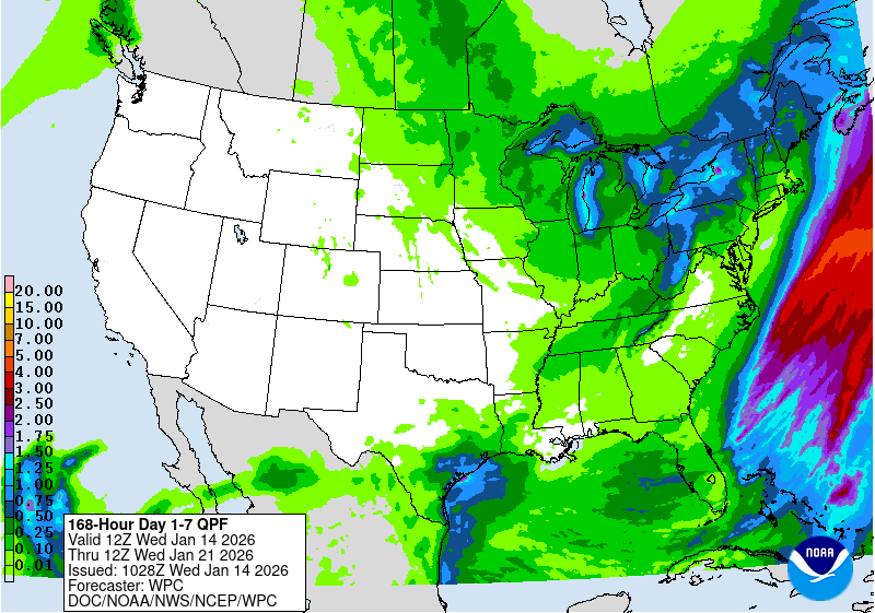
As far as the next 7 days....cold-mild-cold with very little opportunity for significant precipitation.  From the Weather Prediction Center through the end of next week (21st)...


I'll see if I can get an update in later next week....

Thursday, January 23, 2020

Update - January 23, 2020

The active weather regime continues across the central U.S., and has impacted parts of the high plains.  In the previous post I did on the 16th (you can read that one by clicking here), I discussed the MJO that was currently in progress and was probably responsible for the uptick in storms at that time, and that it should continue to provide opportunities for another 10 to 14 days.  I discussed one "small" opportunity due about Tuesday (and it did happen) and perhaps a more impactful storm in the 24th/25th time frame.  There had been little help in forecast models as most had not indicated much at all (at that time).  The possible 24th/25th storms is NOT the one bringing rain and snow to north central/southeast Kansas, Iowa, eastern Nebraska this Thursday afternoon.  That particular possibility of an impactful storm is tied to what "might" happen early next week.  So, that appears to be off schedule by 2 to 3 days.

Before I discuss that possible storm - and beyond....

Here is a map of the estimated precipitation during this past 7 day period....


As expected in that previous post I did, Oklahoma, southeast Kansas and Texas got quite a bit of (mainly rain) during that period.  Farther west, as expected, amounts were quite a bit less but at least there was decent moisture (January-winter standards).  With that additional moisture, a limited area of the drought had improved (mainly eastern fringes).  Here is the latest assessment...


BTW, according to the Climate Prediction Center there won't be much improvement for the High Plains through April.  Texas is another story with removal likely (which would have impacts on the high plains weather this spring).  I'll try and touch on that outlook in later postings when I get an opportunity (free time)....


Looking at this afternoon's satellite image....


An active Madden Julian Oscillation continued impacting the upper level flow across the Pacific and ultimately into the U.S..  It can be partly depicted on the image with the bright colors in the bottom left.  The poleward transport of latent heat release is mirrored on the southern hemisphere side.  The position and intensity of the MJO is resulting in increased momentum in the jet stream impacting the U.S. storms and also into western Mexico.

There is quite a bit of uncertainty going forward with this MJO (that has been pretty robust), depending on what computer model schemes are used.  One, provided by the CPC, has it dying out in about the current position (Western Pacific).


Other schemes have the MJO progressing into phase space 8, 1 and even 2 over the next 3 weeks (influences into the western Hemisphere and Indian Ocean)...


So, going forward for the next month there is quite a bit of uncertainty using the MJO as a predictor.  If the CFS MJO forecast (the image above) is anywhere near accurate, the composites of past MJO's in the predicted phase spaces would yield an increasing threat of cold for February (but not much suggestion for precipitation). Then, using the argument about a cycling pattern (I'm a big proponent)  still points to an active and colder than average February.  However, relying on that technique (soley) led me down the wrong path for December (and it looks like January too) as far as temperatures.  Back in the fall/early winter I suggested that the period December through February would be near to below normal on temperatures.  So far, it's not anywhere close!  If February does end up much colder than normal, then the period of DJF just might average out to what I expected.  But now I'm having reservations about February being that cold.  I'm still going to stick with it with the most likely time for really cold weather from about the 8th through 20th.  I'll adjust that thinking in a couple of weeks.

In addition to the above, the Arctic Oscillation and the North Atlantic Oscillation have been strongly positive (suggesting the really cold air has been bottled up across the higher latitudes).  Those indices are not forecast (accuracy is often poor) to dip much - although that could change as we get into February.


Finally, back to the previous post about the potentially impactful storm for the 24th/25th (which now appears to be early next week instead).  Computer models, at this point this Thursday afternoon, will be of  NO help as their solutions have been all over the place.  My gut feeling is that there will still be a storm.  The million dollar question is will be across Nebraska?  Eastern Kansas?  Oklahoma and east? Or as far west as the high plains?  I still think the high plains could be a target initially and intensifying going east.  But then the question begs "what type of precip?".  At this point, since the potential storm energey is WAY out across the Pacific, there is just no predictability.  Choose your most trusted weather source for local weather and start paying attention later this weekend for details.  I won't have a chance to add anything to this blog until early next week.


Thursday, January 16, 2020

Update - January 16, 2020

In the previous post I did on the 3rd (you can read that by clicking here) I discussed that most of the high plains would be dry through about the 14th through 17th.  For the high plains there wasn't much from the storm that occurred a week ago, but eastern Kansas got a pretty good amount, AGAIN!  Here is the precipitation during the past 14 days....


In that previous posting I also mentioned, that despite computer models being dry through the 20th, that there might be a pretty good opportunity around the 14th through 17th period.  Well, it looks like that is going to pan out pretty nicely! The current storm that is poised to bring rain, ice and a little snow will overspread much of the area through Friday (ending quickly west to east).  Check your favorite weather source for the forecast on this particular storm. Some areas (especially across Oklahoma, southeast Kansas and Texas) are going to get quite a bit of moisture (inches)!  Even parts of the high plains will get measurable moisture (mostly a tenth to a third of an inch - and heavier as you go east).

Here was the satellite from earlier today....


It is a pretty complicated pattern right now with, what I think, is a pretty good contribution to the atmospheric flow from a decent Madden Julian Oscillation (you can see part of that in the bottom left corer - bright colors).   The positioning of the MJO should benefit the high plains for about 10 days to 2 weeks, as far as precipitation.  The opportunities are from the current storm; a small one around Tuesday of next week (give or take a day); and perhaps an even bigger and impactful storm around the 24th/25th time frame!  Here is the latest outlook for precipitation amounts from the Weather Prediction Center through next Thursday.....


One aspect of this pattern is the really cold weather has either been bottled up across the higher latitudes of our hemisphere or has spilled into the Europe and Siberian side.  That might not hold up much going forward.  I'm feeling that the balance of January and for much of February (at least the first 20 days) will be colder than average.  That is NOT saying there won't be mild days, because there will.  But averaging it all out that period should be south of normal.  More on that later as that "could" mean quite a bit of snow during that period too.

I'll try and update again around the 22nd.

Friday, January 3, 2020

Update - January 3, 2020

Happy New Year - and hopefully it will not be a brutal one weatherwise!

December just ended with a very beneficial storm system for a lot (not all) of the high plains.  Here is a map of estimated precipitation:


For a December storm - it was BIG as far as precipitation!  For the cold season very little will be lost to evaporation so this should carry into late Winter, at least.  Will there be more?

In the last posting I did on the 11th (you can read that by clicking here), I said:

Winter (through the end of February) - overall dry with numerous outbreaks of cold, some bitterly.  Now having said overall dry - it will take only a couple of significant storms that "hit" just right and they could bring precipitation amounts to closer to normal.  But, that's an IF they are efficient producing storms.  I do think there will be several of those significant storms.  But there will likely be prolonged dry stretches, with wind unfortunately.

Early Spring - I would count on at least a couple of significant winter storms (i.e, blizzards).


So, there you go.  We just had a significant storm that "hit" just right.  Will there be another?  Most likely but it may be a while.  Plus, the next "big" one could be white with wind.  I should say will be.  It is winter after all.

The precipitation did improve drought conditions.  Here is the latest drought map:


My "gut feeling" for December (temperatures) was  a huge bust!  I thought that December would be colder than normal.  Far from it!  I also thought that significant outbreak of cold would arrive across the high plains the last few days of December and into the first week of January.  NOT!  Now, I did feel pretty good about that feeling a couple of weeks ago.  If you didn't see or hear, Beetles Alaska had all time cold for December and the coldest I saw there was 61 below zero!  Good lord!  That would have been the source to plunge the U.S. into a DEEP freeze.  But, the overall pattern across the northern hemisphere is NOT acting as I thought it would or expected.  So the brutal cold stayed north.  That pattern not behaving could impact my initial thought for the three month winter period as mentioned above in blue.

I'm trying to figure out what is going on.  I might have found an answer, or partial.

The following map of ocean temperature anomalies shows some very interesting data:


First, the warming across the northern Pacific has trended cooler, which isn't too unusual for winter.  The ocean temperatures supporting a weak El Nino continued, especially at the dateline.  So really nothing earth shaking.  But look at the ridiculous warm anomaly east of Australia and the ridiculous cold anomaly west of Australia.   That dipole is crazy!  


That could be partly responsible for the dryness and heat that has persisted down there for some time.  It could also be feeding into the overall hemispheric flow aloft.  That just a speculation.  That same dipole could also be responsible for  a developing MJO across the Maritime Continents .   That location, for January, would favor warmer than normal temperatures across the eastern half of the U.S. but also would favor a period or two of precipitation chances across the high plains going through much of January.

So, even though computer models are suggesting DRY through at least the 20th of January, I suspect that there might be a pretty good opportunity around the 14th-17th period.  Anything before that, if it occurred, would be very minimal as the gulf moisture source is cutoff for now.

It's becoming increasing difficult to update this blog, again as it's on my own time and my own time is limited.  If I every retire from the NWS...well updating this blog daily might be possible.

I'll try again around the 13th.