Monday, June 19, 2017

Summertime weather - Updated 06/19/17

As expected (or feared), the weather made a sudden change to a summertime pattern.  A huge upper level ridge/high has set up over the Four Corners region.  Unfortunately for much of the high plains, temperatures in the middle levels of the atmosphere have warmed enough to prevent much in the way of thunderstorms, at least widespread.  Now, what you see on the satellite image below, is actually a favorable pattern to get the North American Monsoon going (in 2-3 weeks).   This upper high (the big ol' ugly blue H) will meander back to the west or even south and southeast at times and will lose it's magnitude too at times.  What this results in is occasional northwest flow events allowing thunderstorm complexes to move into the high plains.  For the next several weeks there will be periods of "turning hot", brief cool downs (significant at times), dry stretches but intermixed with a few opportunities for thunderstorms.  At least it's NOT a "hot and dry for the foreseeable future".

Here is that satellite image:


We just went through one of the hot and dry periods, especially across parts of the panhandles, eastern Colorado and southwest Kansas.  Then one of those brief cool downs occurred yesterday and today.  The flow aloft will be conducive for a few thunderstorm complexes this week, especially during the evening and overnight hours as that high has shifted slightly west.  Unfortunately (or fortunately for those still cutting) not everyone will get much rain. 

The following map shows how much rain has fallen the past 14 days.  As you can see (or probably already know), many areas have received very little or nothing at all. 

Click for a larger version.

After hot temperatures, especially the last half of this week, the high will be suppressed and will shift southwest.  This will allow another cool down this weekend and into next week.  This next cool down will be even cooler than what came through yesterday and today.  That could favor better chances for rain across Texas and eastern New Mexico.  However, this time of year differences can occur easily with just minor changes in the flow (surface and aloft).

Here is the latest outlook from the Weather Prediction Center for the "average" amount of rainfall possible through this coming weekend.  Some will get more, some less (or much less):

  I'll try and update again by the end of the week.


Thursday, June 8, 2017

Is the gravy train about to leave the area? Update 06/08/17

In the post I did on May 25th (you can read it here), I said...

"Now does this mean this wetness will continue?  Absolutely not!  The faucet could shut off at any time.  But, it's been my experience, and I've talked about it in this blog many times, that once it gets wet and green during the spring across the central plains, there can be a feedback into the atmosphere.  Initially we'll see that with lower daytime temperatures.  I'm going to be optimistic and go with overall above normal precipitation (some areas will be lower) into mid/late summer.  But, I still think there will be dry periods and during those dry periods there should be pretty hot temperatures, just not that long of periods."

It would appear that we are now (after this afternoon's rain) headed into one of the stretches of dry and hot weather.  The question that I'm starting to wrestle with is will the pattern trump the green and wet conditions and have frequent dry and hot periods?

First, here is a map of estimated rainfall during the past 14 days.  Some areas continued very wet (i.e., Ford County where Dodge City is located), while a few others have received below normal rainfall during this two week stretch.  Such is the case with warm season rainfall.

Incredibly, Dodge City is now WAY ahead of the pace to have a record wet year. But as I said, it could shut off at any time.  Is that time now? 

Looking at this mornings satellite image....


There was an anomalously strong upper system moving  into the western US., that will bring much colder weather to the west and then severe weather to the northern Rockies and northern Plains this weekend and into the first of the week.  But for the high plains the EML (Elevated Mixed Layer) will intensify and spread across the area.  This will likely result in temperatures aloft that will be far too warm to allow thunderstorms to occur across the high plains.  It will also result in much hotter temperatures.  As everything passes and digs into the eastern U.S., temperatures aloft "should" cool enough to allow a return of at least scattered thunderstorms by the end of next week.  Thus, it "should" be about a 7-8 day stretch of dry for the high plains.  

Beyond this pattern change and through the end of next week, things get a little fuzzy.  I see some signs of heading into an early summer pattern of hot and mostly dry.  But at the same time, there are still signs of occasional episodes of thunderstorm chances.  Again, once it gets green and wet, there is often feedback into the atmosphere.  But I have also seen patterns of rainfall just completely shut off.  I'm cautiously optimistic that there will still be enough chances for storms that it won't come to a screeching halt with heat getting out-of-control. 

BTW, here is a look at the U.S. drought monitor.  It's pretty impressive the amount of area that have seen a drought removal!  The northern plains (specifically North Dakota) should see some improvement over the next 7 to 10 days.

 ...and the possible precipitation through next Thursday (the precip over western KS was falling today - Thursday)...

 I'll try and post again around the 15th.

Thursday, May 25, 2017

Updated 05/25/17

First let me clear the air.  Several guys have mentioned lately that this free blog isn't being updated that often - and are complaining.

REMEMBER...these posts on this blog are on my own "free" time!  Free time that seems to be diminishing.  My goal is to update often, but dang there is just so much going on!  Anyway, it is what it is. I'll do what I can.

Back to the weather.  As many of you may have remembered, either from posts in this blog or from meetings I've presented at, my thoughts on the growing season and summer were as follows:

In January I was leaning towards an outlook that the warm periods during the growing season would be longer and more intense than they were during 2016.  I was also was leaning towards a drier than normal period (on average for most areas).  However, back on January 25 my confidence of the dryer forecast was decreasing.  The huge storm of rain and ice in mid-January was a sign of changes.  I just wasn't ready to jump on it whole hog.  

Then we got into a LONG dry spell.  In fact at Dodge City we had a 71 day stretch going well into March of only 0.15" of precipitation!  The wind events....the huge wild fire...the blowing dirt!  That had me leaning back strongly towards the drier side as it was fitting the original pattern that established during the fall months.  Also, there just wasn't that much cold air (except for a brief period in December).  Then take into account the following chart of annual precipitation at Dodge City since 1875:

Click for a larger version
In the period of 141 years of record keeping, there has NEVER been 4 years in a row of above normal precipitation at Dodge City!  For 2014, 2015 and 2016 the annual precipitation was above.  So, the odds based strictly on record keeping would support below normal precipitation.  So, for quite a while I felt confident in the original thoughts I had back in January.

But then, WOW!  Mid and late March the upper pattern started resembling the period that brought the huge ice storm, and it hasn't let up since!  Pacific Ocean temperatures along the equator started warming up unexpectedly and the gulf of Mexico remained relatively warm.  Also the energy output from the sun has crashed to low levels!  

At Dodge City (and many areas of southwest Kansas), this has been the wettest start on record (January 1 through May 24)!  Here are the top wettest starts on record:

Of the top 14 wettest starts, all those years ended up above normal for the year except 1978, 1990 and 1999 (at Dodge City).

Of the top six years and cluster of them were very wet for the year.

click for a larger chart


In fact, 1944 ended up as the wettest year on record at Dodge City!


But, not all areas the plains have been as extremely wet.  For instance, there is a stretch around Garden that has been wetter than average, but no where as wet as closer to Dodge City.  Here is the amount and departure from normal for the past 30 days:

 Precipitation amounts (April 26-May 25) - click for larger map
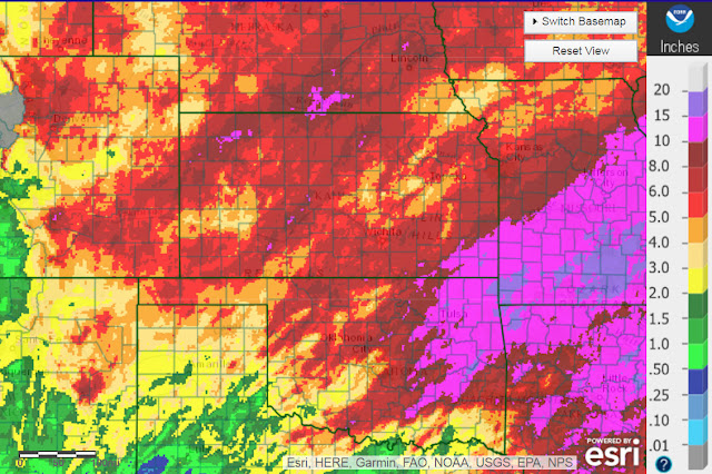
 
 Departure from normal (April 26-May25)

 My gosh!  There are areas of the high plains that have had more than 6 times the normal precipitation for this 30 day stretch (>600 percent of normal)!

Now does this mean this wettness will continue?  Absolutely not!  The faucet could shut off at any time.  But, it's been my experience, and I've talked about it in this blog many times, that once it gets wet and green during the spring across the central plains, there can be a feedback into the atmosphere.  Initially we'll see that with lower daytime temperatures.  I'm going to be optimistic and go with overall above normal precipitation (some areas will be lower) into mid/late summer.  But, I still think there will be dry periods and during those dry periods there should be pretty hot temperatures, just not that long of periods. 

I hopefully can fine-tune this outlook as I get some time.

Btw, the Weather Prediction Center has the following outlook through next Wednesday:


Wednesday, May 10, 2017

Updated 5/10/17

I'll keep this short. In the previous post on Saturday the 6th (you can read it by clicking here) I discussed the storm that is currently upon us.  It's evolution has been almost identical to the ice storm that impacted the high plains on or around the 15th of January.  But, obviously this is May and that January system was during the dead of winter.  The upper level is identical (how it developed, how it has moved, and how it WILL move and weaken) , the impacts will not be.  Here is the latest satellite image as of this Wednesday afternoon:

A close up shows how the air aloft is diffluent and diverging:


The impacts so far for the high plains have been several rounds of at least scattered thunderstorms.  More storms are expected into tonight and isolated to scattered showers as the storm departs and weakens on Thursday.  Here is the expected precipitation amounts, on average through Sunday:

Some will get more, some will get less.

Beyond this system, the atmosphere will become very spring-like.  Each day next week should have a risk of thunderstorms (and some will likely be severe).  This far out, it is impossible to pinpoint just where in the plains.  As we get to that point, I'll try and post an update.  Also next week I'll try and give an outlook going through the remainder of the spring and into the summer.  Stay tuned.

Saturday, May 6, 2017

Update 5/6/17

Well, I wanted to post about the massive amount of rain and snow that fell last week but for the 2nd time I've lost the graphics I was working on.  Ugh.  That will have to come in the next post.  Obviously the storm last weekend was very significant.  Many have said that it's never happened that late before but many have short memories.  One of the latest spring significant snows that have occurred in western Kansas was May 21, 1931.  Another major storm on Mothers Day in (1913?) caused extensive tree and crop damage.  May 2 and 3 of 1978 and again in 1979 there was big snow.  Just 4 years ago on May 2nd there was significant accumulations of snow!  Anyway, the impacts from this latest storm (in the area of the snow) may have been more significant because of the advanced (ahead of normal) vegetative growth.   I hope to do a graphic in the next post when I get a chance next week.  I guess there are all types of issues - plant damage due to the weight of the snow - the freeze - too much water....wait too much after we went through a 2 month period of almost no moisture?  At the Dodge City airport there was a 60 day stretch of only 0.01" (mid Jan - mid Mar) and now it's the wettest start to the year (Jan 1 to May 6) on record!

Currently we're in a transition period with a huge upper ridge across the middle of the county.  The same that "could" bring a brief period of extreme heat this summer.  More on that in later posts...

Another deep weather system will approach the high plains next week.  There are still a lot of uncertainties on the strength and especially the position as it arrives.  I'm not on a computer that I can add my own graphics in this post.  But, this next storm fits perfectly in the cycle of the weather pattern.  This next storm fits the pattern of the mid-January storm.   What this means is that widespread precipitation is expected and amounts will likely be significant.  Here is the latest thinking from the Weather Prediction Center for precip through next Friday (amounts and location will likely change by this time next week):


I hope to have a chance to post later next week to discuss the outlook going into summer.  One thing that I've read and agree with is that the transition month going from spring into summer (May) can be abnormal during the time an El Nino develops.  More on that later...I'll shoot for Wednesday so check back then.

Tuesday, April 25, 2017

Update 4/25/17

In the post I did on Saturday the 22nd (you can read it by clicking here) I discussed the frost or freeze that was impending on the high plains.  I don't know how much wheat was damaged as there were low lying areas that got into the mid/upper 20s on Sunday morning (23rd).  Many areas saw 30 to 34 degrees.   I also mentioned another cold shot slated between April 29 and May 3.  At this point, it looks like freezing temperatures for the high plains are likely, especially for the 30th and 1st.   Believe it or not even snow will be possible at the end of the weekend storm!  That is certainly not unheard of, but given the lack of snow this winter (except earlier this month across far southwest KS and the panhandles).

This afternoon satellite image showed a storm system (the red X) moving towards the high plains:


Boundary layer moisture was just enough that a cold rain (and some thunder) will be likely north of the front that went through Monday night.  The most likely area for 1/2 to 3/4 of an inch of rain will be across southeast Colorado, far southwest Kansas and the panhandles of OK/TX and into northwest OK.  The severe stuff will be far east of the high plains (southeast KS, NE OK and east).

Another system should arrive Thursday bringing additional chances for precipitation.  Then things get interesting.  IF the computer models are correct (and I think they will be to an extent), there should be a deeper and slower moving storm between Friday and Sunday.  There "should" be a prolonged period of precipitation across the high plains of KS/CO and south with snow the primary type across Colorado and far western Kansas during the weekend.  I would not be surprised to see "heavy" amounts too!  I also wouldn't be surprised to see the white stuff as far east as Dodge City.  However, details are highly uncertain at this time.  As the system moves away, minimum temperatures by Monday may be well into the 20s across eastern Colorado and far western KS.

Keep in mind this scenario is still a little iffy (due to the system has not developed and we're still 3 to 5 days out).

Here is the Weather Prediction Center's outlook for precipitation through next Monday.


I won't be able to update this blog until next week due to other obligations.  Stay tuned to local forecasts using weather.gov/

Saturday, April 22, 2017

Update 04/22/17

Time has slipped away with a busy work schedule.  Since I do this blog on my "own" time, it is becoming increasingly difficult to keep up with.

First, in the last post I did on the 12th (you can read it by clicking here), I had mentioned a chilly period between April 23-25.  That time is here and indeed there is some chilly air.  There will likely be frost and a light freeze across the high plains late Saturday night and Sunday morning (23rd).  Then a quick warmup will ensue during the first part of the week.  I had also mentioned another possible period when there "could" be a freeze (with a low probability) for the 29th-May 3.  That is still on track for the high plains. The corn belt will likely see freezing temperatures.   Another "cold" period for the high plains will be during the second week of May but most likely NOT freezing, just below normal temps.

During this past 10 days there have been several weather systems that brought substantial rains to the high plains, but there were also areas that have missed out on much of the rain.  Here is a map of precipitation ending yesterday (Friday) morning and DOES NOT include what fell during the day Friday:


Looking at the satellite image from early this morning,


the system that brought the rains to Kansas had shifted into the Mississippi Valley and was moving away.  High pressure will bring the chance for that frost/freeze this Saturday night.  The red L on the left hand side of the satellite map was a strong storm that will weaken as it moves into the northern Rockies.  The flow aloft will increase and become more westerly which will promote windy and warm weather by Monday and Tuesday.  Any chance for additional thunderstorms this next week will be dependent on how quickly gulf moisture can return into the high plains.  There is some chance that the high plains will be on the "cold" side of additional systems this next week so that the severe weather threat will be farther east.  It looks like at least some precipitation will be possible across western Kansas but I'm not confident at this point since a lot of development has to take place.  Here is the outlook from the Weather Prediction Center through the end of this next week.


Looking further ahead, I still don't have a really good feel for the spring/summer outlook.  I'm leaning slightly on the favorable side for the high plains (NOT west Texas) as far as periodic precipitation and not quite as hot as I thought it could be.  I'll try and nail that down soon.  As far as the corn belt, I still feel that there will NOT be a drought and precipitation should be favorable during the growing season.

Here is the current drought monitor map:


And here is the outlook through July 31 from the Climate Prediction Center:


Wow, that is being optimistic (except the southeast U.S.)!  I'm not saying that it is wrong at this point, but wow!

I'll do my best to update on Wednesday.  If I can't get it done on Wednesday, the next post won't be until May 1.  If only I was retired....