REMEMBER...these posts on this blog are on my own "free" time! Free time that seems to be diminishing. My goal is to update often, but dang there is just so much going on! Anyway, it is what it is. I'll do what I can.
Back to the weather. As many of you may have remembered, either from posts in this blog or from meetings I've presented at, my thoughts on the growing season and summer were as follows:
In January I was leaning towards an outlook that the warm periods during the growing season would be longer and more intense than they were during 2016. I was also was leaning towards a drier than normal period (on average for most areas). However, back on January 25 my confidence of the dryer forecast was decreasing. The huge storm of rain and ice in mid-January was a sign of changes. I just wasn't ready to jump on it whole hog.
Then we got into a LONG dry spell. In fact at Dodge City we had a 71 day stretch going well into March of only 0.15" of precipitation! The wind events....the huge wild fire...the blowing dirt! That had me leaning back strongly towards the drier side as it was fitting the original pattern that established during the fall months. Also, there just wasn't that much cold air (except for a brief period in December). Then take into account the following chart of annual precipitation at Dodge City since 1875:
Click for a larger version
 In the period of 141 years of record keeping, there has NEVER been 4 years in a row of above normal precipitation at Dodge City! For 2014, 2015 and 2016 the annual precipitation was above. So, the odds based strictly on record keeping would support below normal precipitation. So, for quite a while I felt confident in the original thoughts I had back in January.
But then, WOW! Mid and late March the upper pattern started resembling the period that brought the huge ice storm, and it hasn't let up since! Pacific Ocean temperatures along the equator started warming up unexpectedly and the gulf of Mexico remained relatively warm. Also the energy output from the sun has crashed to low levels!
At Dodge City (and many areas of southwest Kansas), this has been the wettest start on record (January 1 through May 24)! Here are the top wettest starts on record:
 Of the top 14 wettest starts, all those years ended up above normal for the year except 1978, 1990 and 1999 (at Dodge City).
Of the top six years and cluster of them were very wet for the year.
click for a larger chart

In fact, 1944 ended up as the wettest year on record at Dodge City!
 But, not all areas the plains have been as extremely wet. For instance, there is a stretch around Garden that has been wetter than average, but no where as wet as closer to Dodge City. Here is the amount and departure from normal for the past 30 days:
Precipitation amounts (April 26-May 25) - click for larger map

Departure from normal (April 26-May25)

My gosh! There are areas of the high plains that have had more than 6 times the normal precipitation for this 30 day stretch (>600 percent of normal)!
Now does this mean this wettness will continue? Absolutely not! The faucet could shut off at any time. But, it's been my experience, and I've talked about it in this blog many times, that once it gets wet and green during the spring across the central plains, there can be a feedback into the atmosphere. Initially we'll see that with lower daytime temperatures. I'm going to be optimistic and go with overall above normal precipitation (some areas will be lower) into mid/late summer. But, I still think there will be dry periods and during those dry periods there should be pretty hot temperatures, just not that long of periods.
I hopefully can fine-tune this outlook as I get some time.
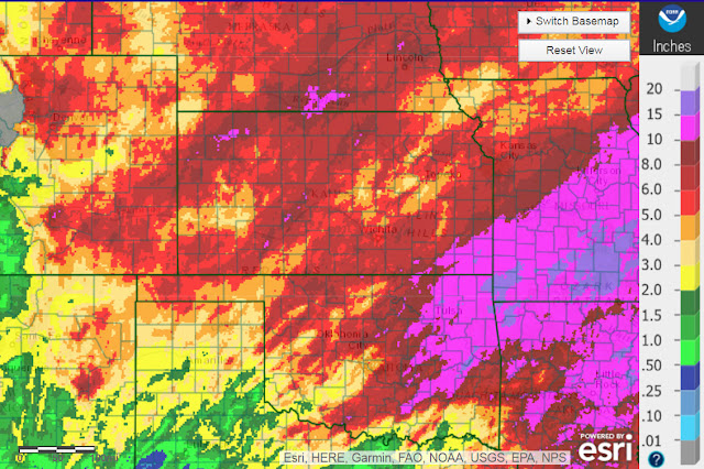
Btw, the Weather Prediction Center has the following outlook through next Wednesday:

No comments:
Post a Comment