Tuesday, February 17, 2015

Update - February 17, 2015 - Unsettled Weather

In the post I did on Friday, click here, I discussed that due to lack of snow cover across much of the northern plains that the Arctic airmass might be modified a bit.  The cold air that arrived Saturday, spreading northeast to southwest, was certainly modified.  While record setting cold has gripped the upper midwest and northeast, here in the high plains it has turned colder but definitely not brutal.

This mornings snow and ice analysis showed more of the country covered - compared to last Friday. 
You can see last Friday's map by clicking here.

One reason the center of the cold, this time, has not impacted the high plains is due in part because of the orientation and location of the upper ridge.  I've marked that location on the satellite image below.  It is farther east this time (as opposed to the November and early January versions).

Another reason, in part, that the Arctic air has not spread back against the Rocky Mountain front range is that the Arctic Oscillation has been strongly positive.  That was unforeseen this go round.


But will both the ridge and AO stay in this configuration?  Not entirely.

The two X's on the satellite image off the Pacific Northwest coast represent two systems in the upper atmosphere that will be rounding the top of the ridge and then will most likely amplify as they turn south.  This should initially bring a brief "warm up" to the area late in the week.  Depending on the amount of amplification and the eventual track, there should be active weather developing in the Rockies by Saturday, and possibly spreading into the plains.  In addition, the amplification will allow the Arctic airmass to move south but also west.  I'll update later in the week, but be prepared for unsettled and increasingly colder weather by the weekend, especially for Colorado.

On the Arctic Oscillation  - if the index dives into the negative during the next 7 to 10 days, then the last week of February would be brutally cold across the area.  I'm not confiident of the severity, but it does look like the balance of the month will be mostly below normal, as far as temperatures.


One of the long range computer forecasting models does show a trend to stay colder than normal right through much of March.  I do think there will be a warmup, but March typically can become pretty variable in terms of weather systems.
 
I would agree that the month on average may end up below normal, but I bet there will be some pretty mild periods too, most likely during the mid part of the month.   This will have to be watched in case it gets "out of control" and gets the winter wheat to break out of dormancy.  Look out for the threat of a March blizzard the last 10 days of the month followed by a significant cold period the first week of April!


Friday, February 13, 2015

Update - February 13, 2015 - The Cold

 In the post I did on Monday (click here) I continued to discuss the cold that I had been expecting.  I  centered the arrival on Valentines day and that appears to be right on track.  In the previous thinking I was expecting about a 10 day stretch with a few days in between of warmer weather.  Even though the computer models have NOT been consistent on the arrival of the cold, I have held steadfast.  Even this morning the models are not that cold.  BUT, I firmly believe we are heading into a cold stretch that may actually last longer than 10 days.  The coldest during that stretch may not be until next weekend, or thereabouts. Yes, there will be a day or two thrown in that "milder" air will briefly return across the High Plains.

Looking at this mornings temperature map the notable cold has shifted east across Canada.  The signal really doesn't support the cold into Kansas, yet.  Initially what will happen is the cold front that moves in tonight and early tomorrow will bring colder air in from the east.  Thus, eastern Kansas will be colder than the high plains. (click for a larger version)


Before I go into more currents and the extended, I thought I would share a graph of the ridiculously mild temperatures we had in Dodge City centered on last weekend.   Although it wasn't the warmest stretch for the winter months (for Dodge), it was certainly significant.   It's interesting that in the record books all these long and mild stretches occurred in February.


Currently 

Looking at the morning satellite of the western U.S. and eastern Pacific, there are several important features.


The first feature is the "L" over the Baja of California.  This is the system I discussed in the previous blog that was to bring a little precipitation to Colorado and near the high plains.  It dropped south through Colorado and now moving southwest to the current position.  It brought pretty good snow and rain and even a little rain into west Texas and the Panhandle.  I don't think this will impact Kansas now that it is were it is.

Another feature is the X headed towards the Pacific Northwest which will help bring in a second front on Monday.  Precipitation with that feature should be confined to Colorado but with a second area forming across eastern Kansas and into the Tennessee valley.

The other significant feature is the "L" that is denoted on the left hand side of the image.  This Low and trough aloft will help pump up of the jetstream and ridge that will eventually unleash some really cold air into the states later next week (and could help bring a day of milder air to the high plains).

Now some of this cold air may initially be modified because of a lack of snow cover across the northern plains.


But with each system some of that bare ground will get a dusting.  The following map is the expected snowfall expected through Monday morning.


Beyond the first of the week the pattern will become complicated and hard to pinpoint. There will be a chance for a least light snow across the plains, but with some amplification there just might be a more significant storm.  I would not expect that possibility until late next week. 

Looking a little further, this cold and unsettled weather may linger into the end of the month. 

More next week.

Monday, February 9, 2015

Update Feb 09, 2015 - Where is the cold air?

First...

As expected this past weekend was ridiculously warm for February with high temperatures on Saturday in the mid 70s to mid 80s across the high plains.  Sunday was a bit cooler but still warm and today (Monday is still on the mild side).  There were daily records set.  But, 80 degree days in February is not that rare as it happens, on average, about once every 7 to 10 years.  So, I would say more unusual than rare.

So where is the cold air I've been discussing for a month or so?  In the last blog, click here, I showed a current temperature map of Canada.  It's amazing, but the map of 2 PM CST temperatures today is just about a mirror image!  Check it out!  Click here for the map from Thursday afternoon and compare it to this afternoons below....

The cold air source is there, it just hasn't moved any.  Part of the reason the cold air hasn't started south is a strong storm moving into southwest Canada from the Pacific.  You can see this storm on the satellite image below...


The storm is broken in two parts but both have forced the jet stream northward.

This storm will turn east and then southeast into the Great Lakes during the next 2 to 3 days.  It will bring snow and ice to the far northern plains and Great Lakes and into the northeast U.S. once again.  Much of the northern plains which does not currently have snow cover will miss out.

The following was the snow cover across North America as of this morning.


Alright, now what about this cold air....  In the blog I did last week I mentioned the cold would arrive during the February 12-16 time period.  At that time the computer forecast models where not even hinting at cold.  In fact, some where keeping mild readings into the last part of February.  But, based on the cycling of the pattern, the extended East Asian Jetstream and the possibility of a storm along the Japan coast, the cold scenario is likely!

In quite a few of the previous posts (please go read them if you have time) I even mentioned that the cold by mid-February could be the coldest of the season.   That is still a possibility.  But even so, what is still very likely is the return of the brutal Arctic air, regardless that the models are not picking up on it.   I'm sticking with my Feb 12-16 period, centered on Valentines Day.   Once the cold arrives there will be about a 10 day period of the cold, but maybe a day or two in between of slight recovery.

As far as precipitation, there should be one or two events during the cold period - which would likely be of the frozen or freezing variety.

I know calving will commence soon for a lot of folks and it just might be during this cold stretch.

I'll attempt an update later this week.

Thursday, February 5, 2015

Update Feb 5, 2015 - Another warm one!

I about choked from laughing recently as I had several people seriously ask me if winter was over for western Kansas.   Hey, warm days come and go this time of year.  Winter "officially" ends later in March during the spring equinox but for North America that really doesn't mean much.  I assure you, there is plenty of winter weather yet to be unleashed.

Another major warmup is in store for this weekend.  I bet there will be plenty of folks on the links, in the yard and maybe even in the fields.  Hopefully homeowners don't get a crazy idea to scalp their fescue or bluegrass lawns this weekend.  I actually saw that happen two weekends ago!  Why not cut?  Because there is still a high probability of very cold Arctic air and the roots will be susceptible to extreme cold causing damage!

I've been advertising the return of an extended period of Arctic cold starting as early as the 2nd week of February.  In the post I did on the 2nd, I said more likely in 10 to 14 days.  That would make it the 12th - 16th (or starting the last part of the 2nd week, right?).   Even though the computer generated forecast models STILL aren't advertising this possibility, I'm still seeing the writing on the wall. 

Looking at the latest satellite image, the flow is characterized as chaotic.  First, the East Asian jet stream has expanded all the way across the Pacific.  This is an unstable configuration.  Second, the flow across the higher latitudes is rather bizarre (see map).  This may have more to do with the weather regime being in what is called a Modoki (pseudo El Nino). It's really strange!  Also, there are numerous upper level disturbances in the flow, most of which are aimed at the west coast.  On the map they are denoted by the red X.  (click on the image for a large version).


Over the next 7 days these storms will hammer the coast from central California to Washington, bringing copious amounts of precipitation.

Some of this energy from the upper level disturbances across the Pacific will drop southeast and then south and produce an unstable flow over the southern Rockies.  In turn, some of this change may very well bring a little rain or snow to the high plains by mid-week (10th - 12th).

That gets us close the period of Arctic air.  As East Asian jet stream buckles the Arctic air should start moving south.  There is already a cold air source (and getting colder).  Look at the Thursday afternoon temperatures!

There is also a storm advertised to form across the far western Pacific, near the eastern Asian continent coast.  Usually, this leads to downstream amplification of the jet stream, which in turn would support the flow to produce much colder weather.

Next week I'll update my thoughts on an increasing probability of a wetter than average late February and March.  Hint - I'm slightly more optimistic than early thinking.

Monday, February 2, 2015

Update - February 2, 2015

In the previous post I did on January 20, click here, I discussed a weather system that was going to impact much of the southern Colorado and into Oklahoma and Texas bringing a lot of snow.  Indeed that did occur, only shifted slight south and east. Click for a large version.


The snow also had a decent amount of moisture in it and will help with short term drought conditions.  But, for the long term very severe drought conditions continue.  The following is the latest drought monitor map:


More recently,  another wet system moved out of the southwest U.S. and combined with an upper level disturbance that had moved out of Canada (and eventually produced near historic snows around Chicago and now - as of Tuesday - heavy snow in the northeast U.S.).  The result of the combination of the two storms produced widespread rain (and some snow) across much of the high plains and especially Kansas.  Click for the largest version


In recent blogs I was discussing the warming that was expected into the last part of January.  The warming the second part of the month pushed the monthly average at Dodge City to above "normal".


In addition, I also discussed the return of brutal Arctic air during the 2nd week of February.  Although there has been a couple of intrusions, those have lasted only a day or two.  What I'm referring to will be an extended period of Arctic air.  So far the computer models have not caught on but I'm still confident that it will happen.

Looking at the latest satellite image, the upper flow across the Pacific is rather bizzare and chaotic. 


Most notable for me is the increasing moisture laden flow that is headed towards the west coast.  With time this should shift south and bring heavy rains (and mountain snows) to at least the northern half of California.  For the high plains, the bizarre flow across the central and northern Pacific should settle down and eventually amplification will take place.  As a result, changes in the flow will lead to a more serious Arctic plunge.  I'm going to hold on to this happening in about 10 to 14 days.  

As far as moisture for the high plains, it looks slim for significant amounts for at least a week.

I'll update later this week.


Tuesday, January 20, 2015

Update - January 20, 2015

In the post I did on the 16th (click here), I discussed the upcoming couple of weeks and forcing from the MJO (Madden Julian Oscillation).  With that forcing would likely be a relatively mild period with a few cooler periods offset by very mild days.  So far, that has worked out.


Also, I mentioned relatively dry weather across the high plains and if there was precipitation it would be minor.  Overnight Monday and early this morning (Tuesday) there was an area of light rain (and snow at higher elevations of the plains) that moved east across Kansas.  Amounts were generally light (less than a 10th of an inch or nothing at all) but there were a couple of 2 inch snow reports near Goodland and points west.

But what I didn't see coming (and perhaps should have) was the system that could break underneath the upper level ridge that has been parked across the west coast.  That weather system is now showing up on today's satellite image.  The X over California denotes the upper levels of the system and it is wet and headed east!


First, the upper system that brought the rain early this Tuesday morning was located across southeast Missouri by Tuesday afternoon.  Another system (X across Montana) will combine with the California system to produce widespread snow Wednesday and Thursday across southern Colorado, far southwest KS, New Mexico and the Texas Panhandle.

The Weather Prediction Center has the following forecast for possible amounts.  That is a pretty robust forecast!  Eventually the system will bring rain to Oklahoma and the remainder of Texas and into the southeast U.S.


Friday, January 16, 2015

Rest of the winter and into the summer - Updated 1/16/15

For those that have followed this blog, I apologize that I haven't updated it since the 28th of December.  Unfortunately my mother passed away unexpectedly on the 2nd and I've been consumed by life's challenges.

In the post on the 28th of December (click here), I discussed a very significant Arctic intrusion that was expected.  Obviously that did verify with the coldest temperatures we've seen in quite a while being observed.  In addition, surface pressures reached record levels at many locations (for December).  That type of cold is likely to return later in February, but I'll discuss that further down in the blog.  With the pattern discussed in the previous blog, it did also bring several rounds of snow.  The most significant occurred on the 3rd of January.

 This Arctic air intrusion is the 3rd major one of the winter (although the first technically wasn't in winter - as you might recall it was around November 11th).  Since November 17, 2015 much of the eastern 2/3 of the country has had below normal temperatures, on average.  And this DOES NOT include that major Arctic outbreak in November!  Yes there has been "mild" periods (as had been expected) but the colder periods have been more severe and has offset the milder conditions.  The map below shows the departure from normal for the past 60 days (11/17/14 to 1/15/15)...


and for precipitation

Notice how wet it has been across parts of California?  That was the result of ONLY about a 2 week period back in December but there really hasn't been much since. Look up there in Montana and Wyoming.  WOW!  The snowpack is getting pretty deep up there which could result in some spring flooding down the Missouri.

Here is a look at the current drought situation:


El Niño or La Nina

El Niño is the warm phase of the El Niño Southern Oscillation (commonly referred to as ENSO) and is associated with a band of warm ocean water that develops in the central and east-central equatorial Pacific. An El Niño is accompanied by high air pressure in the western Pacific and low air pressure in the eastern Pacific. The cool phase of ENSO is called "La Niña" with SST in the eastern Pacific below average and air pressures high in the eastern and low in western Pacific

Back in the summer months there were MANY "experts" claiming a Super El Nino would be coming for the winter.   A so called Super El Nino would be one with a very large anomaly on the warm side.  That type, like what occurred back in the 80s, would normally bring flooding rains from California to Florida.  Some folks, me included, had doubts that a full fledged El Nino would even form and if it did would be weak.  (you can look back at previous posts in this blog) So,what has happened?  It's barely been an El Nino event.  Looking at the Southern Oscillation Index (which can chart and El Niño or it's sister La Nina) there is indications that this very weak El Niño may already be waning.

In the chart above, for an El Niño the index needs to be consistently less than -10 for at least 3 months.  The green line is a 90 day average.  Do you see the trend going back towards the positive?

Ok, so big deal, right?  Well lets look at the following map that shows what the jet stream and sensible weather does (normally) during an El Niño or La Nina.  Keep in mind it's just a composite of events so there are caveats.  


The northern hemispheric wind patterns and sensible weather across the United States has been any BUT an El Niño pattern.   In fact, it more closely resembles a La Nina pattern. So in essence what I'm saying is the wind patterns have been more La Nina like in an El Niño forcing environment.  Confusing I'm sure.   Suffice it to say that one CANNOT predict the weather based solely on ENSO.

So now what?  Well, one of the forcing areas for our weather (even with or without ENSO) is what comes out of the Maritime Continents of the southwest Pacific.  It is called the Madden Julian Oscillation (MJO).  Currently there is a rather coherent signal from a pretty good MJO that is moving across the central Pacific.  The MJO takes about 45-60 days or so to develop and dissipate as it moves east and then southeast across the equator. 

The center of the MJO is denoted on the following map by the big X.  The upper wind field is denoted by the green arrows and is mirrored across the equator.


Currently the forcing is going into what is called the warm phase (6 and 7) and indeed the forcing is being realized across much of the country, including the central plains.  Temperatures as of Friday afternoon were in the 60s across a large part of the area.  I'm expecting, in general, above average temperatures for the next 2 weeks, but with a brief period or two of colder weather.

Along with the warmer weather, it will be mostly dry across the high plains.  There could be a weak system that could bring some precipitation but if so, it would be minimal. 

Changes are then expected towards the end of the month, say sometime after the 23/24th.  It looks like the high plains will go into a more active pattern the last part of the month and into February.  Although an Arctic outbreak is not expected during this period, there will be much colder air (just not severe Arctic) I would bet there will be several high impact storms. As time closes in I will surely update with later thoughts.

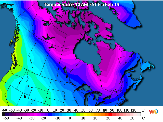
By the 10th-15th of February (probably closer to the 15th) I believe there is a high probability of another major Arctic air outbreak.  This time I would suspect we might see temperatures as cold and maybe even colder than this last one.

Then for the remainder of the winter there will likely be several warm/mild periods followed by more cold. I'm guessing at this point that a late spring freeze will be probable along with a late season blizzard somewhere across the central high plains.  There will also be windy and dry periods too.  As we get later into March and April I would expect several strong cold fronts with high winds and probably episodes of blowing dirt - not good for the winter wheat.

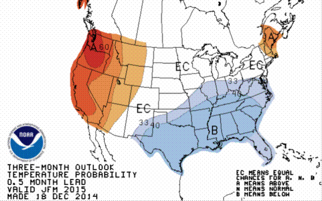
Beyond early spring and into the summer I'll just offer what the "official" outlook is from the Climate Prediction Center and NOAA.  Later this month or by early February I will give my own personal take on it.  Early thinking is the precipitation outlook "may" be optimistic.

Temperatures - the average for January-February-March


Precipitation - the average for January-February-March

Temperatures - the average for March - April - May

Precipitation - the average for March - April - May

Temperatures - the average for June - July - August (Summer)

Precipitation - the average for June - July - August (Summer)