Tuesday, September 30, 2014

Update - September 30, 2014

In the last post (click here) I briefly discussed the substantial precipitation that was expected across the west and for some precipitation for the plains.  I also mentioned the possibility of severe weather.  Those that may have caught the news or surfed the net, there was very severe hail in the Denver area on Monday and there were severe weather reports all the way down into southern New Mexico.  


Today (Tuesday and Wednesday) there is a risk of more severe weather across the central and southern plains.  

Rainfall from the first system that ejected into the plains was very robust across northern Colorado, western Nebraska and into the northern plains.  In the local area there was also generous rainfall across about half of the area.  The map below shows the 24 hour precipitation that ended this Tuesday morning.


There will be a chance for additional rainfall through Thursday.  The best chance for the high plains will be Wednesday night and Thursday as another developing upper system moves out of the Rockies.  As of Tuesday afternoon this system (denoted by the red X on the map below) was moving into the Great Basin.  The first storm (denoted by the red L) will drive a cold front into Kansas and then this front will interact or act as a focus for rainfall as the Great Basin system moves out.  Rainfall will likely be heaviest across eastern Kansas but much of central High Plains should receive at least some rainfall by the end of the week.


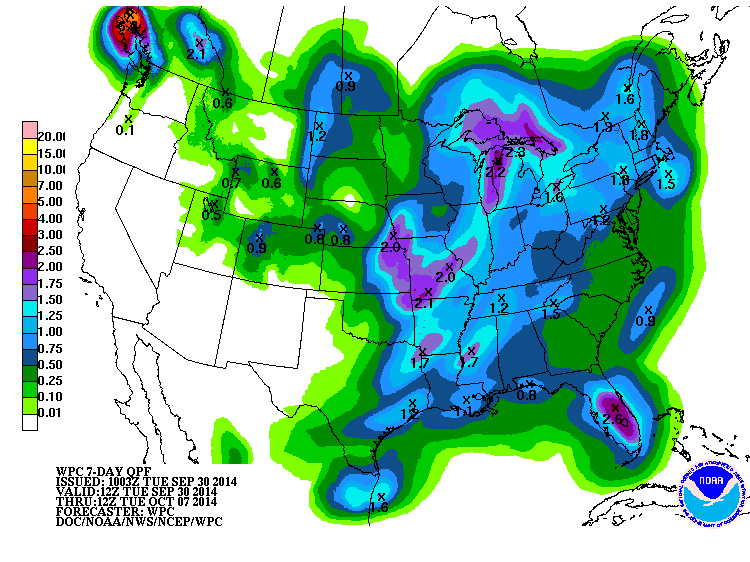
This next map shows the possible precipitation amounts through early next Tuesday.
As the second Great Basin system moves out there will be some chilly air drop south behind it.  I would not be surprised to see low temperatures fall into the mid or upper 30s as far south as Dodge City and Elkhart by Saturday morning.  Freezing temperatures will be likely across the northern plains.

In the context of freezing temperatures, there has been a "killing" freeze across areas that normally see one by this time of year.  BTW, a "killing" freeze is one where temperatures fall to at least 28 degrees for several hours.  The following map shows where a killing freeze has already occurred.


...and this map shows the dates of the average first 28 degrees or colder of the fall...


For much of Kansas the first episode of 28 degrees or colder can vary considerably from year-to-year but the median date runs from October 11-20 across the northwest to November 1-10 across the south central and southeast.  Remember, this is for a "killing" freeze and not frost or light freeze.  

Looking ahead, I'm starting to see SOME indications of an active period from around October 11 - 17 and if this comes to pass I would bet there will be some pretty cold weather following in the wake of that period.  Pretty cold?  A killing freeze.  This scenario is just a possibility since right now there is NO computer model even remotely hinting that this could occur.   In addition to the cold, there SHOULD be an opportunity or two for more precipitation.  There will also be a chance or two for rain during the second week of October.

As we get deeper into October the weather may become increasingly active but confidence at this point is rather low.  I soon as I see a pattern start to evolve, I will put out the seasonal outlook.  Early indications based on some forcing locations across the northern hemisphere is for at least "normal" precipitation for the fall and winter across much of the area.  I'm tilting the odds in favor of a wetter verse dryer pattern. Temperatures may see some wild swings but the average into the winter should favor normal to below.

More later on the outlook - I've got to gather more data!

Remember this is not an official discussion - it's my thoughts only.  

Thursday, September 25, 2014

Update - September 25, 2014

Due to being on travel and attending workshops and meetings this is a late update....

The big news during the past 7 to 10 days is what happened to the remnants of what was once Hurricane Odile that moved up the gulf of California and heavily damaged one of the Mexican resorts.   If you go back an look at the blog post I did on the 15th by clicking here you will see the discussion about what Odile might do.  At the time there was a "chance" that the remnants would curve east/northeast and head towards the central plains, including Oklahoma and Kansas.  There were concerns about the amount of precipitation that might occur.  As it turns out there was SO much convection (thunderstorms) that the latent heat release from those storms (and from interruptions from the mountains of New Mexico) that the storm turned more east and southeast!   It is probably a good thing too as rainfall from the remnants was EXTREMELY robust and there was a lot of flooding issues.   Look at the map of precipitation the past 7 days where there was over 20 inches across southeast New Mexico and west Texas!  WOW!


Across Kansas and adjacent states, the rainfall was more spotty.  Although, there were areas that did receive quite a bit of rain and most of this occurred late on the 23rd.


The rainfall across the southwest U.S. and into Kansas has continued to make a dent in the long term drought or in some cases completely alleviate it.


The Weather Prediction Branch (WPC) of the National Weather Service is indicating some substantial rains during the next 7 days across much of the western U.S.   WPC doesn't have a lot of precipitation across the regional area, but at least some.  There should be another front arrive in Kansas late in the weekend or first of next week so there should be at least a chance.  We'll have to watch that system carefully as the second season of severe weather will be ramping up and it's not out of the question that severe weather could occur during the first part of the week.  It's just too early to give much detail. 

The latter part of the week should see a significant cool down and  even freezing temperatures across the northern plains.  I'll address that in a post next week.  Then, into October some of the long range models are still indicating ample precipitation.  The "wet" computer model I've posted about lately is still indicating above normal precipitation (notice I said precipitation and not rain? hint hint).


With a bit more time on my hands I'll attempt the seasonal outlook in a blog by October 3.

Please feel free to share this blog.

Sunday, September 14, 2014

Update - Monday, September 15, 2014

As predicted the cold shot last week was pretty substantial.  Across much of the midwest and plains states there were NUMEROUS record cold temperatures observed late last week.  In Kansas there were several sites that saw temperatures below freezing.  The coldest I saw in Kansas at an official NWS location was 31 degrees at Ness City.  It got down to 30 at a mesonet site near Jetmore!  High temperatures Friday were only in the 40s and 50s and across Wyoming and the western Dakota's there was heavy snow with as much as 10 inches reported!  I've talked briefly about this in previous posts but I "think" the cold was the result of the pattern that started last fall and was waning during the late summer.  In the same token the pattern that delivered the cold may be tied to forcing that has been in place across the northern Pacific that helped produce the long term pattern in the first place.  Hint - the forcing remains (and is likely to persist this winter).  I will do a fall/winter outlook later this month when I have more time to devote to the outlook.  Look for that outlook around the 24th-26th.

Rainfall this past week was most widespread across Colorado, the northern half of Kansas and into Missouri.  Since the 1st of September there have been quite a few areas that received some beneficial rains, especially across some of the driest areas of the drought. The following map shows the rainfall that has fallen:


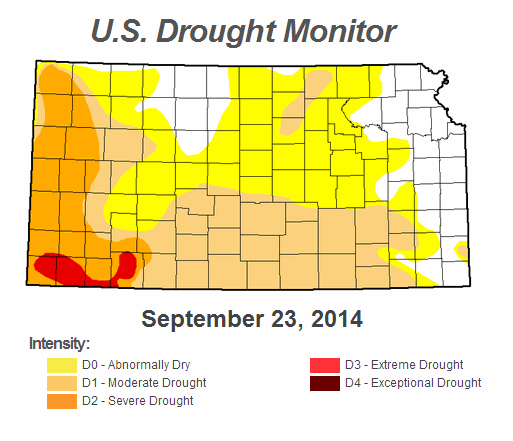
The U.S. Drought Monitor continues to show improvement across the central and southern plains.


Back to the cold.  I'm guessing that the stretch of cold has set back the maturing of the sorghum?  How about the beans and corn?  As I mentioned in earlier posts, September should end up below normal on temperatures.  There will still be some very warm (and windy days) but those days will become less numerous.  As of this writing another significant cold front had moved across much of the area with temperatures only in the 50s.

The next big weather maker will likely be the remnants of Hurricane Odile that was moving into the Gulf of California Monday.  This Monday afternoons satellite image shows the massive amount of moisture associated with the hurricane. 

 
The remnants will help support very heavy rains across the southwest U.S. which has been hard hit this past month.  Currently it appears that the remnants will then move east into the central plains by the weekend and should enhance rainfall chances.

The Weather Prediction Center generated a map this afternoon which showed the possible rainfall amounts during the next 7 days.  The story here is additional significant rains across the drought stricken areas of the plains and even central and northern Texas!

In earlier posts I mentioned the possibility of September being above normal on rainfall.  If the remnants of the hurricane do in fact track as depicted, then yes the month will end up above normal.   One of the computer models (that really is not that accurate but depicts trends) continues to indicate a wet fall.


The map above shows just several ensemble (computer runs with slightly different initial conditions) iterations and most are wet into late October.

What about El Nino?  It is S L O W L Y developing or so it would appear.  Temperatures off the southern part of Australia (southern hemisphere) continue to cool and is increasing the ocean thermal circulations which is helping this warm event (El Nino) develop.


NOTE:  A prolonged period of negative values indicates an El Nino. 

I'll hopefully find some time to post again in a week.  Remember to share the link for this blog (if you find it useful anyway).   The link is:  swkswx.blogspot.com

Thursday, September 4, 2014

Update - September 4, 2014

Did you notice the change to the blog page name?  This is no longer a "Spring and Summer Outlook" as I've been summarizing what has happened, what is occurring and what is in store.  Please share the link swkswx.blogspot.com.  It does take time to put this together and I'm not entirely sure it's worth my time.  The thoughts are mine and not thoughts of my employer.  If you want "official" outlooks, go to the Climate Prediction Center

Also, please visit the previous post if you have not already done so by clicking here.

I'll start this post by showing the precipitation that fell during the previous 7 days (actually from 8/27 through 9/2).


As has been typical for a while, some areas got excessive rainfall while others missed out on getting good rains.

An update to the current drought...


Looking at the precipitation deficit/surplus at the Dodge City airport...we are doing pretty good for this Wateryear (2014 which started Oct 1, 2013).  But the longer term going back to October 1, 2010 is not as rosy but continues to improve.


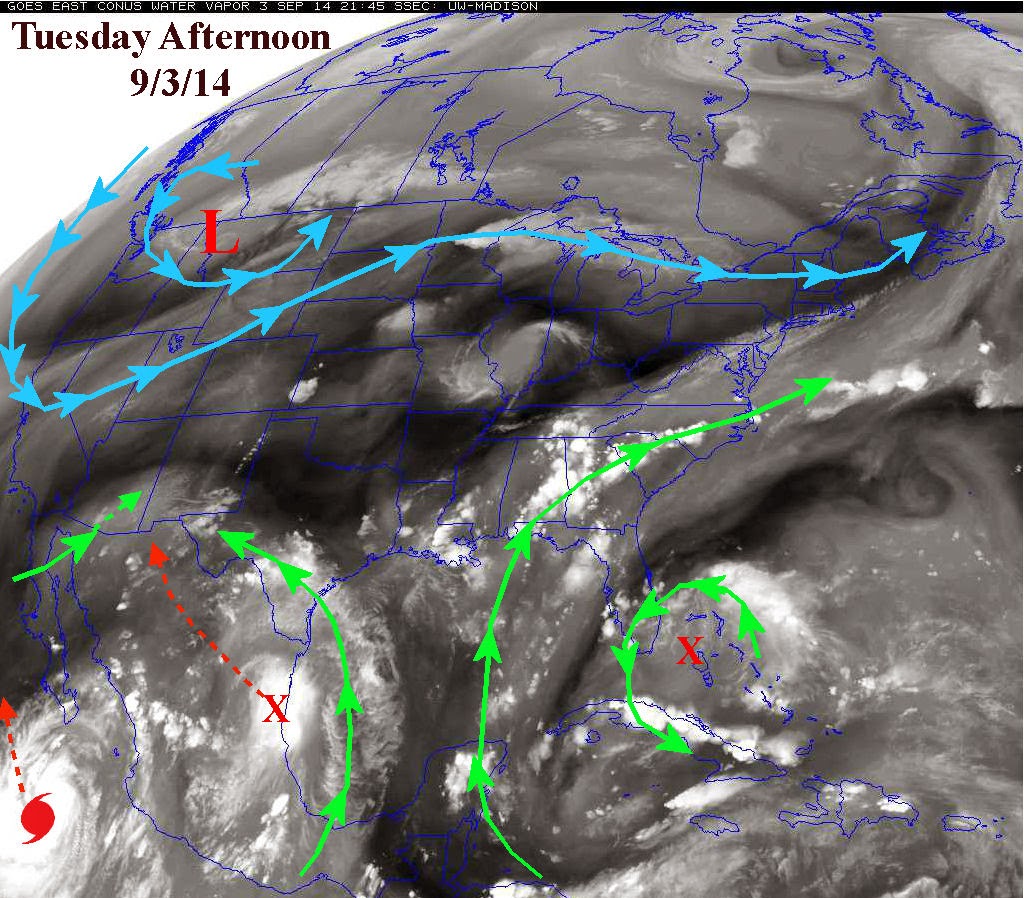
The satellite image from 9/3 shows several interesting and big "play makers".


First there is that low up across western Montana.  The associated jet stream is taking quite a dip into the northwest part of the country.  This will ultimately deliver some rather chilly air into the Conus, including southwest Kansas.  Low temperatures this week will fall well into the 40s across the northern plains and even well into the 50s across Kansas.  This will further delay the maturing sorghum and corn.  This HAS to be of concern, right?

The other features that will impact Kansas is the X across Mexico (depicted in the above map) which will help deliver energy and moisture in the southwest U.S. and even into the panhandles of Texas and Oklahoma, which a glancing blow to southwest Kansas.  The other will be remnants of the hurricane  moving towards extreme southern California.  The result will be copious amounts of rainfall across the southwest deserts and into Texas and Oklahoma and eventually across the corn belt.  The following map is the 7 day estimate of potential rainfall courtesy of the Weather Prediction Center.
I will be doing a fall and winter outlook soon, at least by September 23-24.  In the meantime, there is still NO El Nino, but it is steadily looking like one will develop late this fall and winter.  That would have at least a bit of an impact on sensible weather.  More later....

The following map shows the Southern Oscillation Index - the trend strongly in the negative for an extended period indicates an El Nino.


Tuesday, August 26, 2014

Updated August 26, 2014

Click here for the previous post done on the 20th of August.

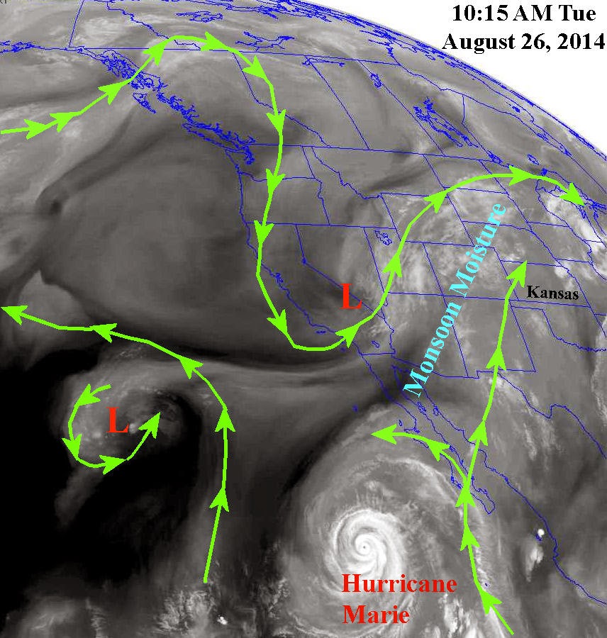
A few more changes are taking place in the overall weather pattern across the northern Hemisphere.  The most notable has been the "strong" upper systems dropping into the Great Basin area.  The first brought copious and excessive rainfall to Montana over the weekend.  There has been major flooding reported from the rains.  The second upper system had dropped into the same location of the west and was lifting out as of Tuesday afternoon.  The result of this was an anomalous increase in the North American Monsoon (NAM) moisture as indicated on the satellite image below.  You might also notice the very intense hurricane (Marie) in the eastern Pacific with some of the moisture being drawn north by the upper system.


The setup is there to produce widespread rains over the next 5 to 7 days across much of the central Rockies and adjacent plains states, especially along and north of a frontal boundary that should set up across northern Kansas and Nebraska.   Looks like much of the corn belt will be receiving a lot of rain...and cooler temperatures. The following map shows expected precipitation amounts over the next 7 days and is courtesy of the Weather Prediction Center from NOAA:


 Adding these amounts to what has fallen between August 20th and today (26th), there are going to be some areas of Colorado, Nebraska and even parts of Kansas that will be quite wet by the end of the month.  The following map is amounts that have fallen in the past 7 days:


In the previous post (please take the time to read by clicking here) I had mentioned the possibility of a wet September and early October.  The "wet" long range computer model I had discussed continues to have a wet outlook, although not quite to the extreme.  This model is not necessarily that accurate but as I mentioned before the trend has been there for some time.


What about El Nino?  It is still struggling to develop but S L O W L Y seems to be developing.  Remember, for an El Nino (and there are several regions that it develops and "lives"), the numbers need to be strongly negative for at least 3 months.  It is trending that way at least.   More discussion on that in  a later post...


All thoughts are my own and are not intended as an official statement.  Please share the link for this blog...

http://swkswx.blogspot.com/


Wednesday, August 20, 2014

Update - August 20, 2014

Please see the previous post here.

Amazing as it may seem, it appears the atmosphere is already starting to transition out of Summer across the northern Hemisphere!  There is a lot going on right now.  The North American Monsoon (NAM) continues, although farther to the west.  Arizona has been getting pounded lately with heavy rain and flash flooding.  Rains have diminished across Colorado, and for the most part across much of Kansas.  There still have been scattered storms and looking at the map below you can see just where the rains have occurred since August 1st.


The next map shows the percent of normal.


But, even though the NAM continues (albeit farther west) the jet stream winds are increasing across the northern Hemisphere.  This is a little ahead of  schedule.  That could be because of the tropics (land and ocean areas) are continuing to warm while the Arctic, or above 80N is cooler than normal.  Looking at the satellite image from Tuesday there are a couple of interesting features across North America.


There is that "low" again across the Great Lakes.  Seems as if we've seen that quite a few times this summer.  If that repeats again in September....more on that at the end of this post (but don't cheat and skip over the rest of this).  The other feature is the low (L) over California.  This low will eventually lift out into the Rockies and move east or southeast across the northern and central plains late in the weekend and first of next week.  The result will be a cold frontal passage and a dramatic increase in thunderstorms across the plains.  Look at the precipitation prediction through early next Wednesday (provided by the Weather Prediction Center)! That is a lot of rain across the northern plains!

You might also notice the generous precipitation signal for the northwest half of Kansas.  As we get closer I'm sure this area (and amounts) will be refined.  I'm pretty confident that much of northwest Kansas will get quite a bit or rain with lesser confidence into southeast Colorado and the panhandles of OK and TX.

The drought continues!  Yes many areas have seen beneficial and sometimes excessive rainfall this summer (but not everyone).  However, officially much of the high plains is still in a drought.  Why?  Because it takes a long time for a major drought to develop, and it takes a long time to get out of one.  We're with out a doubt moving in the right direction.  But looking at the deficit of precipitation over the past 3 or 4 years there is still a significant one.  The following maps show precipitation at Dodge City since October 1, 2013 (considered a water year) and precipitation since October 1, 2010 (combined water years).  You will be able to see the deficit I'm talking about...


Officially much of the area is still in a drought (but again it's improving)....


So the outlook through the middle part of next week is for an improving chance for precipitation, especially late in the weekend or early next week.  Temperatures should be gradually coming back down after this week.  This current week may be about the "hottest" stretch that will occur for the balance of the summer.  That may not be good news for the late maturing corn, sorghum and acres of northern cotton .  Yes there will be more hot weather but the prospect for a long stretch is very low.  In fact, there is some indication that as September approaches there may be quite a few below normal temperature days.  That leads me back to the statement earlier in this post about that low over the Great Lakes returning.

Let me first state that weather patterns that become established in the fall will generally repeat at various cycle lengths and amplitudes and continue through the winter, into spring and summer and completely diminish by August or early September.  So the pattern that has been in place this year actually started last fall, but is about to "disappear" and re-establish.

If this pattern across the northern Hemisphere can continue and repeat just one more time, then there is a greater than climatological chance of a rather cold airmass invading the U.S. sometime in mid to late September.  That would mean a frost or freeze much earlier than normal, especially across the corn belt and perhaps into Kansas.  It's not out of the question we could have a hard frost or freeze in Kansas around September 25, give or take 3 or 4 days.  However, if that doesn't happen, the new pattern that will be developing will likely set up to be a colder pattern, meaning there could still be an earlier than normal freeze.  More on that in a later blog as I attempt to give an outlook for the fall and winter.

Finally, I want to briefly discuss a long range forecast model that is run 4 times a day.  It's not precise or extremely accurate but it has shown  trends in the weather pattern.   When I have an idea of the weather pattern in my mind and if this model supports my notion, then I tend to look at it a little more closely.  The model run from yesterday (Aug 19) evenings upper air soundings and global current conditions yielded an extremely wet outlook into early October!  It has also been very consistent in showing a wet signal for several days.  I was already leaning for above normal precipitation for the early fall - not that I believe this run completely but it's something to consider.  The graph below shows predicted accumulation of precipitation for Dodge City through early October.  Initial conditions were changed slightly yielding a different outcome providing 5 different solutions or forecasts.  The black line is the average of the five different runs.    Basically the result is record rainfall between now and October 4th.  Do I believe that?  No, not really.  BUT, it does support my thoughts of above normal precipitation.  I guess if somehow the model was completely accurate then there would be major issues of getting fall crops (if they can even mature) out of the fields and get the winter wheat up and growing without getting it washed out of the ground.  The same computer forecast model has shown an outlook of below to much below normal temperatures for the fall.  I tend to agree with that notion also.


I'll update again next week.  

As I mentioned in the last post, if you find this blog useful or helpful please share the link.   Again, these are only my thoughts and NOT an official outlook from the NWS or NOAA.

Tuesday, August 12, 2014

Update - August 12, 2014

The previous post on July 30, 2014 (click here) was discussing the heavy rain event that was progressing across the area. There were a couple of locations that had excessive VERY rainfall.  Once was out in eastern Colorado near Eads where amount of 7.64" was measured!  Another was just northeast of Greensburg that had 5.03 inches!  The following map depicts the total ending on the 30th...


For the month of July there was quite a bit of variance across the area, which is very typical for the warm season where the majority of precipitation falls from thunderstorms.  Thunderstorms produce highly variable precipitation rates, depending on many factors.  The following map is for July....


There were only a couple of days that had "hot" temperatures above 100.  At Dodge City we've only had 2 such days this year.  (I have mentioned several times in previous posts that there probably wouldn't be many 100s this summer and so far that has worked out).  The 15th through the 18th had anomalously cold weather with daytime temperatures staying in the low to mid 60s on two of the days and only in the 70s on the other two.  Did this stretch do anything to growth of the corn and sorghum?  The number of growing degree days will undoubtedly be less than normal for this growing season.  This "cold" also has stretched across much of the corn belt.  It will be interesting to see IF these crops can mature before the first freeze arrives.

For the next week or so the pattern will be characterized by a continued North American Monsoon (NAM) and periodic cold front passages.  The  satellite image from a couple a days ago shows several interesting features.  One is the low and moisture that has finally impacted the Pacific Northwest.  Another feature that has been persistent this summer is the little low associated with the NAM poised to move north into the Great Basin and will be moving into the plains (mostly northern) the last half of this week.  Another feature that REALLY has caught my attention is the system over the Great Lakes and which brought very excessive rain to New England this week along with colder air.  If this feature returns in September then we can expect a very early FREEZE across the corn belt.  Could be a major price mover as we get closer?  I'll keep an eye out for this possibility and post at a later date.  Here is the aforementioned map...


With the recent rains this summer the drought has improved at most locations.  There are still those "unlucky" ones that have missed out on the big rains.  Surely that luck will improve?


I'll be posting my thoughts on the fall and winter later this month.  The well advertised El Nino has NOT developed yet.  But, slowly but surely, it's starting to look like it may be developing.  The latest SOI chart below shows the progress.  Remember the indices need to be strongly negative for about 3 months for an official El Nino event.  It's complicated but El Nino is not the only feature that will calls the shots for later this year and into 2015.  Again, I'll post something on this a little later this month.


If you find this blog useful, please pass the link on.  There doesn't seem to be much traffic right now.  As I posted earlier during the spring, this is NOT an official posting from the NWS.  This is ONLY my thoughts.