The big news during the past 7 to 10 days is what happened to the remnants of what was once Hurricane Odile that moved up the gulf of California and heavily damaged one of the Mexican resorts. If you go back an look at the blog post I did on the 15th by clicking here you will see the discussion about what Odile might do. At the time there was a "chance" that the remnants would curve east/northeast and head towards the central plains, including Oklahoma and Kansas. There were concerns about the amount of precipitation that might occur. As it turns out there was SO much convection (thunderstorms) that the latent heat release from those storms (and from interruptions from the mountains of New Mexico) that the storm turned more east and southeast! It is probably a good thing too as rainfall from the remnants was EXTREMELY robust and there was a lot of flooding issues. Look at the map of precipitation the past 7 days where there was over 20 inches across southeast New Mexico and west Texas! WOW!

Across Kansas and adjacent states, the rainfall was more spotty. Although, there were areas that did receive quite a bit of rain and most of this occurred late on the 23rd.

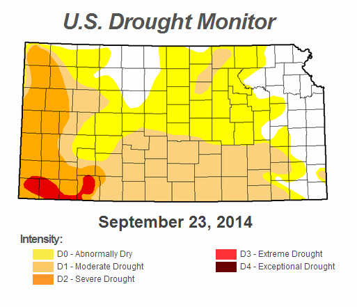
The rainfall across the southwest U.S. and into Kansas has continued to make a dent in the long term drought or in some cases completely alleviate it.

The Weather Prediction Branch (WPC) of the National Weather Service is indicating some substantial rains during the next 7 days across much of the western U.S. WPC doesn't have a lot of precipitation across the regional area, but at least some. There should be another front arrive in Kansas late in the weekend or first of next week so there should be at least a chance. We'll have to watch that system carefully as the second season of severe weather will be ramping up and it's not out of the question that severe weather could occur during the first part of the week. It's just too early to give much detail.


With a bit more time on my hands I'll attempt the seasonal outlook in a blog by October 3.
Please feel free to share this blog.
No comments:
Post a Comment