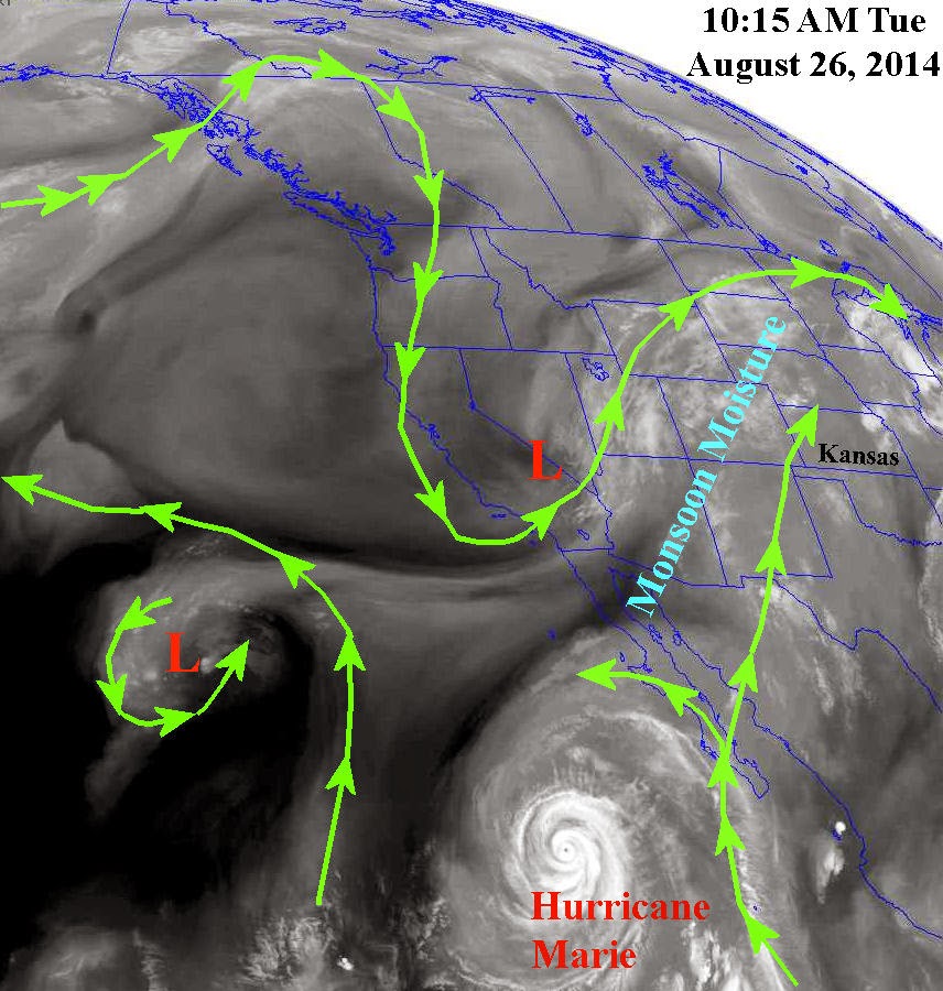
A few more changes are taking place in the overall weather pattern across the northern Hemisphere. The most notable has been the "strong" upper systems dropping into the Great Basin area. The first brought copious and excessive rainfall to Montana over the weekend. There has been major flooding reported from the rains. The second upper system had dropped into the same location of the west and was lifting out as of Tuesday afternoon. The result of this was an anomalous increase in the North American Monsoon (NAM) moisture as indicated on the satellite image below. You might also notice the very intense hurricane (Marie) in the eastern Pacific with some of the moisture being drawn north by the upper system.
The setup is there to produce widespread rains over the next 5 to 7 days across much of the central Rockies and adjacent plains states, especially along and north of a frontal boundary that should set up across northern Kansas and Nebraska. Looks like much of the corn belt will be receiving a lot of rain...and cooler temperatures. The following map shows expected precipitation amounts over the next 7 days and is courtesy of the Weather Prediction Center from NOAA:

Adding these amounts to what has fallen between August 20th and today (26th), there are going to be some areas of Colorado, Nebraska and even parts of Kansas that will be quite wet by the end of the month. The following map is amounts that have fallen in the past 7 days:

In the previous post (please take the time to read by clicking here) I had mentioned the possibility of a wet September and early October. The "wet" long range computer model I had discussed continues to have a wet outlook, although not quite to the extreme. This model is not necessarily that accurate but as I mentioned before the trend has been there for some time.

What about El Nino? It is still struggling to develop but S L O W L Y seems to be developing. Remember, for an El Nino (and there are several regions that it develops and "lives"), the numbers need to be strongly negative for at least 3 months. It is trending that way at least. More discussion on that in a later post...

All thoughts are my own and are not intended as an official statement. Please share the link for this blog...
http://swkswx.blogspot.com/
No comments:
Post a Comment