Friday, September 23, 2022
Transition Time
Monday, September 12, 2022
The bleak outlook continues
At least a "few" areas got some rain with the colder airmass this past weekend but even those that got rainfall, most locations got less than a quarter of an inch, or less. That system producing the rain benefited areas farther northeast, which may an indication of the "new" pattern that is weeks away from setting in motion. Here is the broad and close up look at what fell...
In the posting I did on August 16, I said "a possibility of a decent front centered around September 6 and maybe that could bring some rain that would be key for fall planting later in the month."
I missed that one by 3-4 days. It's most unfortunate that rainfall wasn't widespread and amounts were likely to little to benefit the fall planting.
As mentioned in the posting I did on the 1st (read it by clicking here), September is a transition month from the old to the new pattern that develops during the fall. Predictability really goes in the toilet. At this point I can only go off of some of the computer models. This week will become brutal with a lot of wind and increasing temperatures. By the weekend we could even be flirting with 100 again! The key to this week will be warm air aloft. If it doesn't get too warm aloft, then there should be a few days later in the week when there should be at least scattered thunderstorm activity. Again, unfortunately, any activity will likely be scattered in nature, but least I'm hoping for something. IF I can use some of the knobology from the waning pattern than started last fall, there should be another significant cool down later next week, say between the 20th-23rd. Maybe another shot of rainfall then too?
I'm sure most of you have seen various "forecasts" for the winter. Caution....much of what you see is not based on weather science. There is one map in particular that was first posted 5 years ago and has shown up on social media every year since - the EXACT SAME MAP! Predicting what this winter will be like is nothing more than a guess and a wild one at that. Predictability is ZERO as the new pattern has not set up yet.
Some are making the prediction off of the notion that a third La Nina in a row will exist. And yes, this will be a triple dip (3rd La Nina winter in a row). However, if looking for a predictable weather solution solely off the existence of another La Nina for the high plains - nope. All La Nina events (and El Nino for that matter) have a different outcome for the plains. But, what if....what if we could predict based on the existence of another third La Nina?
I can find 2 back-to-back La Nina events during the past 50 years. 1973-1976 and 1998-2001. The sensible weather for the plains was NOT the same during both events! But taking into account the last year of the two (1976 and 2001), the fall (Sep-Nov) across the high plains was colder than average with near normal precipitation. So, could that same thing happen this fall? I suppose so but at the current time all long range computer forecast models are indicating warm and dry into November. I certainly hope not.
I'll try and update again early next week sometime. Let's hope and pray for something later week.
Thursday, September 1, 2022
Again? Hit and miss rains!
It seems to be a common theme this warm season. There have been locations that have received decent rains while others are missing out completely. It happened again.
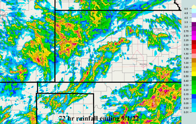
In the previous posting I did on the 19th of August, a carry over period of opportunity that I started discussing back in June mentioned the last of August. That opportunity definately benefited some across the region. Here is the rainfall that fell this past 72 hours ending this morning 9/1....
There were 2 events covering this precipitation.
Prior to that from last week into the weekend...here is the 72 hour map ending 8/29
Back to the post on the 19th, there was quite robust outlook for rainfall across Oklahoma and Texas. This also verified (I'm sure many heard about the flooding in the Dallas area) but the spatial area impacted was perhaps a little less and it was a little farther south.
We are now getting to the time of year that the old pattern that developed last fall is nearing a completion while the next pattern that will be developing this next month. It's going to be really tough giving you any indication of what to expect going into October. All the longrange forecast models I've looked at are indicating a warm and dry September and likely a warm and dry October. There is simply NO skill in forecasting for October at this point since the new pattern will be emerging then and it's impossible to predict what that will be. I do see a few opportunities for rainfall....fist tomorrow into early Saturday and then perhaps towards the following weekend, September 16-18. Skill on those predictions is decreasing rapidly. In the meantime, here is the outlook through next Thursday the 8th.
I'll attempt to update late next week.
Friday, August 19, 2022
Another quick update
If you missed the last post on the 9th, please read it (click here). There really isn't much to add to that post. As we get deeper into September, perhaps I will start to see the evidence of the "new" pattern that will begin to slowly show itself.
In the previous post on the 9th, I said "If fact, in my analysis that I've been using to pick out periods of opportunity, the next date(s) will be centered on August 18, for just a few days. If you miss out on that, then the final opportunity for August should be towards the end of the month. In between - hot and dry.
The date of the 18th worked out for some of you but as is typical, many missed out - again. The significance was the area that "had" been extremely dry across southeast Colorado and far southwest Kansas got a pretty soaking! Here is a map of rainfall for the 72 hour period ending yesterday the 18th (morning)....
Other than what I was expecting for the end of the month and also the period in September mentioned in the previous posting ( a possibility of a decent front centered around September 6 and maybe that could bring some rain that would be key for fall planting later in the month.), there really isn't anything else I can pick out as the weather pattern starts its transition. Hopefully more on that when I get a chance to post again. I know fall prep and planting is coming up later in September. Obviously getting rain this next 2 to 3 weeks will be very critical.
Finally, here is the expected rainfall through the end of next week (provided by the Weather Prediction Center), which by the way is extremely significant for Texas!...
If this amount of rain verifies, will that impact weather going into the fall? I think so. More on that later.
Tuesday, August 9, 2022
Quick update - The weather pattern will be slowly fading
In the previous post I did on the 29th (click here to read it), the final period of opportunity first identified in the June 14th post was August 3-7 Below normal temps and above normal rainfall. The period prior was for July 25-28 and I was off a few days on that, so naturally the August 3-7 would be off a few days too. Although there was cooling from the 105 degree weather, the average temperature was closer to normal and slightly below starting on the 8th but it will be brief. Rainfall was there (so above normal for some, but not all) that started on the 5th. Here is the rainfall for late August 5th through yesterday the 8th.
There was definately a shift farther west and north this time around. The upper level dome of high heights has shifted just far enough west that most of Kansas and Oklahoma will lose almost all opportunity for rainfall for at least a week, if not more. If fact, in my analysis that I've been using to pick out periods of opportunity, the next date(s) will be centered on August 18, for just a few days. If you miss out on that, then the final opportunity for August should be towards the end of the month. In between - hot and dry.
Here is the rainfall outlook from the Weather Prediction Center through next Tuesday...
The weather pattern that was established last fall will be fading away this next month as we go into September. Weather events by September will still be influenced by the same pattern. But as the westerlies (upper level winds) begin to strengthen again across the Northern Hemisphere, we'll start to see a shift as October approaches (a combination of old and new influences). In my analysis, I do see a possibility of a decent front centered around September 6 and maybe that could bring some rain that would be key for fall planting later in the month.
Friday, July 29, 2022
Rain event was on schedule!
This will have to be very short as I have very pressing issues...
On June 24th (click here) and again on July 14th I mentioned one of the periods I had picked out to have below normal temperatures and above normal rainfall ("July 25-28 cooler again with a above normal rainfall".). That was amazingly on target although just a few days early. Here is the rainfall that has occurred this past 72 hours with the majority falling this past 12 hours ending at 11 AM this Friday, the 29th.
Temperatures have moderated accordingly due to the cloud cover and precipitation that will persist through the weekend.
The heat returns next week but it should be moderated by the amount of rain that has fallen (and will continue to fall this weekend). Humidity will likely be a bit higher with the heat.
The next period I had identified (in June and again earlier this month) is:
August 3-7 Below normal temps and above normal rainfall.
The North American Monsoon will continue and hopefully it will slide over again and influence the high plains weather at that point. I'll do my best to post next week but no guarantees.
Thursday, July 14, 2022
Brief update - this is ugly!
In the previous posting I did a week ago on the 7th (click here to read it), I again listed specific dates that I had first posted on June 24. The period of July 12-18, I posted "July 12-18 A cooling trend with less hot temperatures. A better than normal chance for thunderstorms, especially July 14-17" and ended with "It's going to continue to be a struggle for systems to produce widespread rain events. The North American Monsoon (NAM) has abated a bit (but still going) and let's hope it can regenerate strongly.".
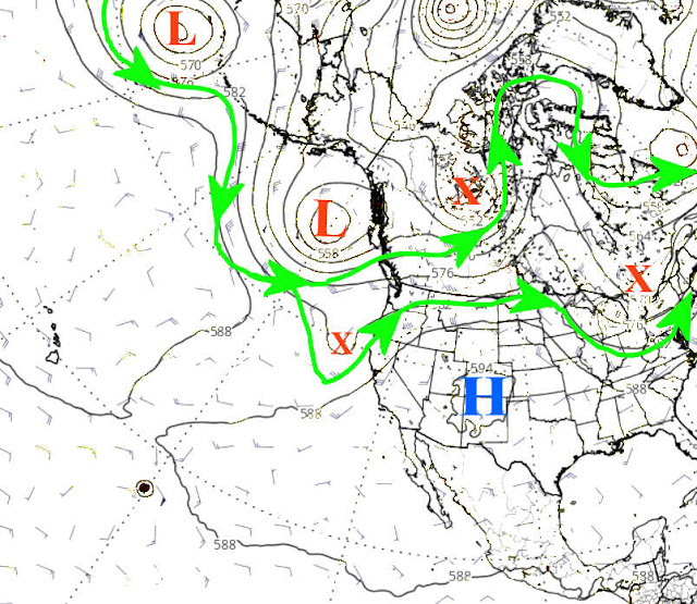
So a little explanation is needed. The key on precipitation was that last quote, i.e., "it's going to continue to be a struggle for systems to produce widespread rain events". The cooling did occur, but lasted a whopping 2 days! That is NOT good! The 12th and 13th were below normal. But the remainder of the period is going to be above to much above normal! That is tied to the expanding upper level high as seen in the upper air map...
That upper high has become very strong, most unfortunately! This will lead to an extended period of very hot temperatures. Those that have missed out on the rains this past 4-6 weeks will suffer the most.
Back to that original post of "A better than normal chance for thunderstorms, especially July 14-17". The better than normal chance came early with 3 days of thunderstorms on the 11th-13th and because of the expanding upper level high the coverage was dismal. Here is what fell this past 72 hours....
The North American Monsoon (NAM) has strengthened again but unfortunately has shifted west and too far west to benefit most of the high plains. But, here is the outlook for precipitation and keep in mind the precip indicated for some of the high plains indicates light amounts...
Hot is here to stay for a while. In the June posting (and recapped in the July 7th post), I added "July 25-28 cooler again with a above normal rainfall". But keep in mind that it will continue to be a struggle for widespread rainfall. Essentially there could be 100+ degree temps every day through much of the next two weeks before there is "any" hope of cooling (not that it will be cool by any stretch). Back in the fall I had made several comments of the similarities to 1956 (the driest year on record at Dodge City). I'm still holding out on August with some opportunities. But this might be a run away train at this point so at this time I'm definately not feeling optimistic.