Friday, February 5, 2021

It is Winter After All - update Feb 5, 2021

For the most part it's been an abnormally mild winter - so far.   With the weather pattern that was established during the fall, the initial thought was that any brutally cold periods could be somewhat infrequent.  Without knowing what the main influence on the weather pattern was, confidence on temperature and precipitation patterns was not very high.  

First - back to the post I did on the 22nd.  I've been discussing a mid-month chance of the next significant precipitation event (for the High Plains), specifically a day or two around the 15th. What is currently going on across the northern hemisphere (and on our side - as opposed to the Asian continent) may mitigate what happens around the 15th.  

First things first.  Those that have read this blog for many years have read about the Arctic Oscillation (AO) and North Atlantic Oscillation being a contributor to our weather, especially during the colder months of the year.  A very high percentage of the time when the index of the AO becomes negative for a period of time, high latitude (particularly Arctic) airmasses are dislodged into the U.S.. Look at the AO for the past 3 months and what is expected for much of February (the gray shade)....


The sigma numbers on the left scale indicate the Standard Deviation from normal (SDN).  A 2 to 3 SDN is extremely significant and for the index to be that low/strong for that long is mind blowing.  Sometimes this means the cold is the other side of the hemisphere but other times it is on our side. But, the cold usually oscillates from "that side" to "our side".  That hasn't happened until currently.  We're about to pay for that relatively mild winter!

Here was this mornings upper air chart....


The big red L up across the Canada is the "polar vortex" (strong upper level low) that has been displaced south and west from a typical winter location.  This is in a perfect position to allow surface high pressure to get very high and move the Arctic air south.  BTW, this setup is a direct result of something called Sudden Stratospheric Warming (Google that if you want to know more) that occurred a couple of weeks ago.  The red X near the Canada/Washington border is a fast moving upper level disturbance that will help spread snow across Nebraska and the northeast half of Kansas late tonight and Friday.  Behind this system will be the first surge of Arctic air into the central U.S..  

But there are other disturbances that will be sliding southeast across the central U.S. into the first of the week.  The Arctic air will mitigate very briefly but then come in with a vengeance Sunday night and stick around through next weekend (the 13-14), at least.  I would not be surprised to see single digit highs later next week with a possibility of low temperatures falling well below zero (-10 to -15 depending on clouds clearing out and any snow cover).  This is for the high plains.  Farther northeast temperatures will be even colder!  

As far as precipitation next week, there should be several rounds of snow that eventually will add up to several inches.  But, it will be a very dry snow with very little moisture with it.  As far as a significant storm around the 15th as indicated in the past few blog posts - there could still very well be one but with the airmass being so cold and eventually very deep (the cold air), an organized storm does not seem likely.  It's still possible, just not likely.  But, there should still be a period or two of snow.  By the 15th and after several rounds of snow, there could be snow depths of at least six inches across some areas of the high plains.  Here is the precipitation outlook through next Friday (from the Weather Prediction Center)...


Since any snow would be dry in nature, it won't help much with the drought.  Here is the latest map valid for February 2.


I'll try and update next week and discuss the trend through the rest of February and into March. 

Friday, January 22, 2021

Update - Jan 22, 2021

 In the previous post on the 8th (read it here) I mentioned the last 7-10 days of January and into the first few days of February should be much colder with a couple of chances of precipitation.  This morning there were single digit temperature readings a few locations across the high plains with mainly teens observed.  This was after a couple of "mild" January days. Single digit temperatures were widespread across the Midwest.  This signals the start of the change.  It is puzzling why the bitter cold air hasn't made much push into the U.S. since the Arctic Oscillation has been extremely negative for a long period of time.  The cold air is there, it's just on the other side of the hemisphere.  I don't know about you, but I'm perfectly fine with that!  So far for December into the 22nd day of January it's been around the 10th warmest start to winter on record! 

On average, the balance of January into early February will be characterized by normal to below normal temperatures - but still with a few days on the mild side.  As far as precipitation (and as advertised in the previous post on the 9th), there will be several opportunities for rain and snow.

Looking at this mornings upper air map...

The atmosphere is set up to deliver several of those opportunities for moisture.  But, as usual, the million dollar question is where and how much!  This morning there was an upper level low across northern California and it was moving east and southeast.  But it will quickly be kicked out and will quickly die out as it swings into the Rockies.  The culprit is a strong disturbance associated with a jetstreak (maxima in the jet stream winds) that will be diving south.  This disturbance will intensify and take a track denoted by the red arrow on the map.  This will be the precipitation maker for late Sunday and Monday.  However, that system has a LONG way to track so it's really up in the air as to the exact track and how the corresponding surface features develop.  Also the area and intensity of the precipitation will be highly influenced by potential thunderstorms across Oklahoma and Texas. The precipitation will be mostly snow across Kansas, Nebraska and Iowa.  You'll want to check with local forecasts from your favorite source for detailed information.  As of this Friday afternoon the bullseye of heaviest snow seems to be from Salina to south central Iowa.  Here is a best guess for 4 inches and higher...


Back to the upper air map.  There was another strong storm out in the Pacific and it appears that it will take the green track.  But there are indications it will undergo weakening as it moves into the plains.  It's impossible to predict eventual surface features and precipitation areas, but it should impact the high plains and points east sometime around mid-week.   Here is the outlook from the Weather Prediction Center through the end of next week (taking into account the two storms mentioned above)...


Beyond the two upcoming opportunities, there should be at least one more system that may impact the high plains around the first couple of days of February.  Confidence is low.

Then, I would wager a quiet period until mid-February.  Around the 15th of February, it has my attention on being the next significant chance for a storm across the high plains.  But, then maybe nothing again until late in the month.  If we miss out on these opportunities this next 40 days, the drought area will start to expand again, even though it's still winter.

I'll end this posting with a discussion about the Madden Julian Oscillation (MJO).  There is a developing MJO that is forecast to become pretty strong.  There is pretty good consistency with computer models on it's eventual evolution.  In previous discussions I talked about the "phase space" for the MJO.  If indeed the MJO becomes as strong as indicated, the impacts typically are noted in the map below going through much of February...


This would favor the areas that have been so wet this past 2 months, especially the mid-Mississippi Valley.  For the high plains there is "some" signal of above normal precipitation.  But I feel there are other contributors to weather pattern so I don't want to get too optimistic for February.  However, that mid-month opportunity could make the entire month, if it occurs.  

I'll try and update again around the 29th.

Friday, January 8, 2021

It's all on track - Updated 01/08/21

 In the previous post (click here) I discussed the storm(s) that were going to impact areas mainly east of the of the high plains.  That did happen, with the exception the the southern high plains got a decent snow from the parting storm.  Here is a look at the precipitation map for the 14 day period ending this morning...


That is an impressive amount moisture for areas of Oklahoma, eastern Kansas and into Texas, especially for the winter time.  With this additional rain (and snow), the drought map shows how much improvement has occurred in that region, and keep in mind this does NOT include what fell earlier this week.

In that previous post I said "That could very well impact the central U.S. once again around January 9, give or take a day.  That should be the next significant chance of precipitation after this Thursday/Friday (again east of the high plains)."  

Once again it looks like a system will indeed be present and is right on schedule!  But this time the main precipitation event (and it appears to be almost all snow) will be farther west and south impacting mainly the southern high plains again and then eventually deep into Texas.  Here is the upper air map...


As of this morning the system was entering the west coast and racing east but had taken a turn southeast as it began amplifying.  Here is the outlook for precipitation through the end of the next week with the the precipitation depicted for the plains occurring late tomorrow (Saturday) into Sunday.


Back to the upper map. There was a very energetic upper level low across the eastern Pacific (depicted by the red L), but it appears that it will rapidly weaken and move north.  This tells me there is a change going on across the Pacific Ocean Basin.  What does that mean for the high plains?  Nothing initially as it fits the weather pattern.  It's too bad as that system, if it were to continue moving east, could have been a big weather maker for the central part of the U.S., but not this time.

So, after this weekend, much of this following week there should be a pretty good warm-up, especially for the northern high plains.  I don't see much chance for any precipitation for the work week.  The next significant change, will probably be around the 18th (give or take a day) with a significant cool down expected and with another chance for precipitation across the plains.  In general, the weather the last 7-10 days of January should be much colder with a couple of chances for precipitation and this should carry into the first few days of February.  Details to follow.


Tuesday, December 29, 2020

The Bad, The Good, and The Bad - and Maybe Ugly (12/29/20)

If you didn't get a chance to read the previous post I did on the 24th, click here.  

The advertised precipitation event I discussed back on the 17th, was just a tad slower in evolving.  Some of the precipitation began the night of the 27th with a band of snow that moved across west central Kansas into northeast Colorado, northern Kansas and into Nebraska.  The second wave of precipitation began last night and into this morning (29th).  Here is a precipitation map from late on the 27th until 7 AM this morning....


The rain, freezing rain and sleet that started overnight and continued through much of the day as it shifted east was not necessarily a single storm.  Rather it was a maxima in the upper level wind field that promoted what is called a "warm conveyer belt" and produced lift across the relatively shallow cold airmass aided by a surface warm front that was moving up into southern Oklahoma.   Here is the 24 hour precipitation map for Kansas, ending at 4 PM and provided by the Kansas State Mesonet...


So, the bad.  Well, this "significant" precipitation event was farther east than what would have been preferred for the drought area of the high plains.  That has been a common theme for much of the fall and now early winter.  Comparing the map above to what occurred around in early November...this pattern of precipitation was farther east by about 50 miles (in regards to the heavier precipitation).  These sharp gradients of very little to a whole lot have repeatedly occurred this past 70-80 days.

The Good?  It was another significant precipitation generating weather system for the central U.S. that was "right on track" as far as long range predictability.  This boosts confidence going forward for other potential impacting events.

The bad or maybe ugly?  The same area that has missed the big events may miss many of storms going into spring.  The caveat is that some of the forcing areas around the northern hemisphere generating these storms have changed slightly.  My hope would be the pattern could shift west a little, with time.  

Looking at this mornings upper level chart....

                                                          500 MB - 12/29/20 at 12 Z


The main upper level storm was located across western Arizona.  Typically this would be a nearly perfect location to impact the high plains.  However, because of upper level ridging across the north Pacific and something referred to as Rosby Wave Propagation across the entire Pacific basin, this upper level low is predicted to take a track closely resembling the red arrow.  That is, the upper level low will intensify/amplify as it dives across northern Mexico before lifting rapidly northeast and then north across the mid-Mississippi Valley.  That will result in a tremendous amount (remarkably high) of precipitation (mainly rain)!  However, that track also keeps the precipitation out of the high plains.  IF, the storm were to take a track annotated by the green arrow, then we'd be in good gravy.  That won't happen (99% chance it won't).  Here is the outlook from the Weather Prediction Center (and keep in mind this in addition to what fell today)...


The western edge may be a bit too far west. 

You may also notice lots of precipitation across the west coast.  Great for them!  It also is an indication of an active upper level pattern across the Pacific.   I'm seeing indications of a developing extended east Asian jet stream (very energetic winds coming off the mainland due to very high pressures across Siberia).  That could very well impact the central U.S. once again around January 9, give or take a day.  That should be the next significant chance of precipitation after this Thursday/Friday (again east of the high plains).


Thursday, December 24, 2020

Merry Christmas!

 In the previous post on the 17th, and it was a long one, I discussed a potential significant storm centered on December 27, give or take a day or two.  There was a lot of information in that post and you can read it here.  Ten days away and I put that date out there.  At the time there were NO computer forecast models with anything at all through the end of the year.  As late as 21st there was a lot of social media from various folks discussing above normal temperatures and below normal precipitation with NO storms through the end of December.   I was patiently waiting for those computer models (and the forecasters) to finally pick up on the possibility.   So, here we are on the 24th and I'm sure a lot of you have already heard the chatter about a significant storm next week.  Is it a slam dunk at this point?  No, not yet because of the complexity of what is going on with the jet stream, especially across the Pacific.

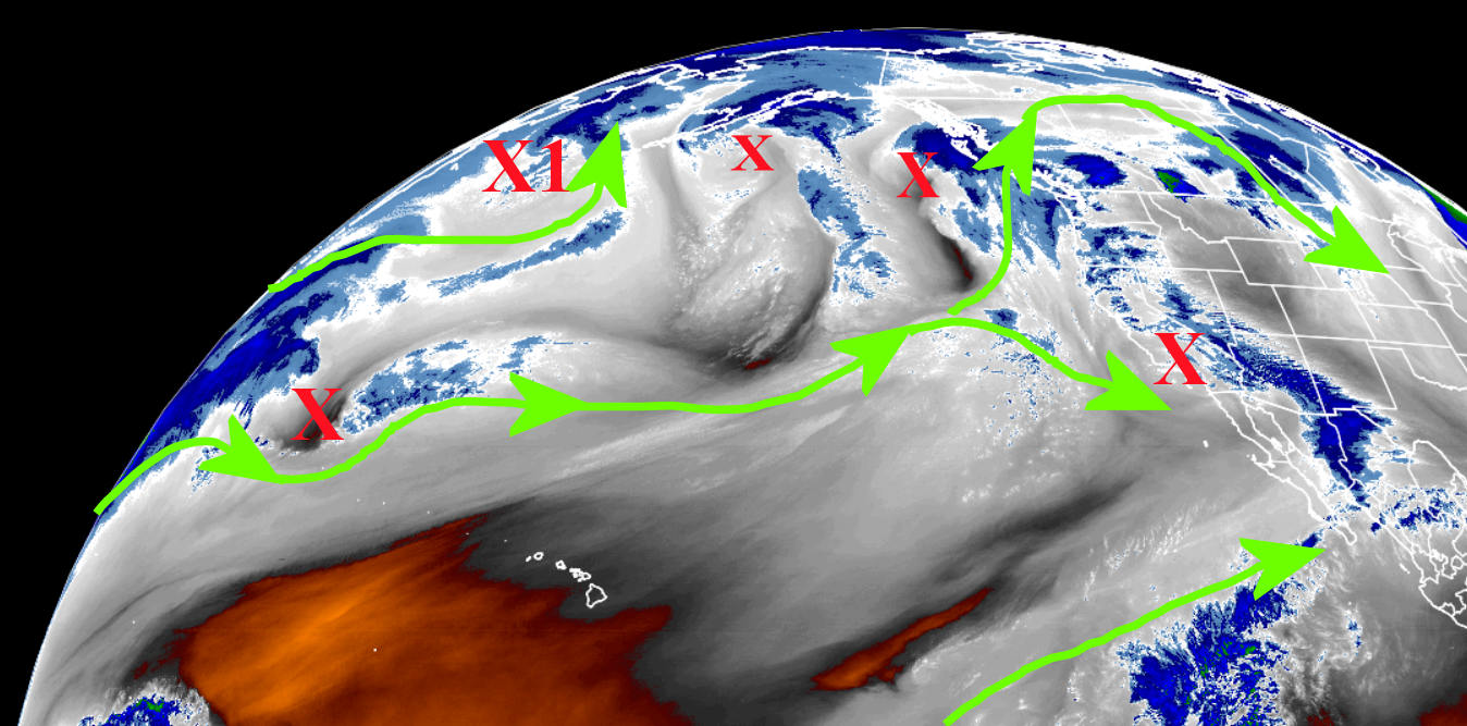
Here is a snapshot of the atmosphere late this afternoon....


The winds aloft across the Pacific are active and very complicated.  There are several source regions for energy, both tropical, mid-latitude, and higher latitude influences.  The red X's are disturbances (or storms) aloft with varying intensities.  The one that has my attention I labeled X1 near the Aleutian island chain of Alaska.   This disturbance in the wind field "should" begin to amplify as it approaches the west coast.  If not, there may be another development.  Regardless, amplification of the wind field should occur across the western U.S. starting late in the weekend and the result will be a widespread precipitation event for the central U.S., including much of the plains.

What makes a forecast with any detail impossible at this point is that it is uncertain which disturbance will become the main storm.  How amplified will it be?  What track will it take?  Exactly when does it move across the plains?  How cold will the airmass be?  Will it be cold enough to support all snow?  Freezing rain?  Sleet?  Thunderstorms?  Wow, there are MANY possibilities!  At this point, it's best to follow weather.gov as we get closer to the event.  You will see many computer solutions on social media, and THAT I can be certain about.  Some of these computer model solutions I've seen have ridiculous amounts of precipitation.  Some solutions (from the American model) keep much of the high plains dry while others are very wet.

As for that date of the 27th that I mentioned in that blog posting on the 17th...it looks like there could already be a little freezing drizzle as early as late on the 27th although the main "show" will probably be later on the 28th into the 29th.  

Here is an "early guess" from the Weather Prediction Center on precipitation amounts incorporating this potential storm.  At this point, it's just a broad brush of possible amounts.  Again, details are not possible at this point.  


If I get a bit of time, I may try and update this blog late Sunday or early Monday.


Thursday, December 17, 2020

The pattern has started to repeat - I think (updated 12/17/20)

This one will be a long one....

The previous posting was on the 25th of November (you can read that one here) and I waited to update with a purpose.  As many readers are aware, the repeating or cycling of the "new" weather pattern that develops in the fall and the periodicity of that repeating is not known until the first cycle has ended.  Looking closely at the northern hemispheric upper pattern, I believe pretty strongly that the second cycle has begun and has a relatively short cycle length. So, now there should be slightly higher confidence of what is possible going forward.  However, there is still a small chance that the cycle time may be up to 12 days longer which completely screws up the timing of  forecasting certain high impact events.  I'm going forward right now based on the shorter time scale.

In that previous post, I ended with: "Looking ahead I suspect that mid-December ought to get really interesting based on a hunch, thinking the wavelength is around 55 days give or take."  I now believe the wavelength (cycle) is on a shorter time scale; perhaps as short as 48 days, but that would have still led to an active mid-December for at least southwest Kansas and into western Oklahoma.  As most of you are aware, unless you've been in a coma, it has been pretty active this December.  Now, I do see a problem at the moment.  The geographical region targeted by these storms has been relatively small in areal extent.  Not all locations of the drought area has benefited which continues to be a concern.

For December, there has been what would now be considered a near record amount of snow at some locations.  Look at the closeup of how much snow has fallen in the 3 storms for December!


The 3 storms have targeted basically the same area but with a tight gradient (especially to the north) of very little to a whole bunch! 

The drought map shows improvement where it snowed significantly.  Here is the latest map ...


After this last storm on the 15th, the snow field was pretty impressive viewing from satellite....


Back to the earlier storms, here is a map of snowfall from December 3rd and the view from satellite from that particular storm (sorry I changed the color scale)...


And here is the snowfall map from the storm on the 12th/13th and notice the target area is basically the same....


Imagine trying to forecast for a particular county.  On the 12th/13th event, the snow amounts across Ford County (Dodge City) were from around 2 inches to over 12 inches!

So, now what?

One key element through the end of December will be the Arctic Oscillation.  It has gone strongly negative (very cold air building up in the high northern hemispheric latitude region).  It is also projected to go even more negative by the end of the month. I haven't seen it projected to be this negative in a long time.  But, we'll see if it actually does go that negative.


Essentially this cold air buildup which is reflected in the negative index will help to energize the polar jetstream even more than it has been.  I expect that there will be rapid and significant changes upcoming.  The first impact is what produced the snow across the area a few days ago on the 15th and eventually the mega ice and snow storm across the eastern part of the U.S. (several reports of 4 feet of snow) yesterday and today.   The next two systems impacting the central U.S. will be fast moving with little or no moisture to work with so I don't believe we'll see much precipitation, if any, and only a glancing blow of cold air.

So with a pretty good idea of the cycle length, if I'm right about the time period, then here is what I expect...

1) There should be a pretty good warmup leading up to Christmas.  Now, the snowpack will definitely impact (or mitigate) the amount of warming.  Those areas of the high plains without snow cover will see a few days next week that should be pretty mild!.  Timing of particular fronts will always be a challenge across the high plains, regardless of weather patterns in place. 

2) The next chance for a significant storm will be a day or two centered on the 27th (Dec).  However, if that storm does occur, it is impossible to predict if it will be the southern, central, or northern high plains.  Based on what has been going on this month and with the projected phase of the Arctic Oscillation, I would favor the odds to be closer to southwest Kansas.  The balance of December after the 27th and into the first few days could be pretty cold!

3) Mid-January could be pretty active (8th-20th) but confidence of that period is still very low.

4) I would put high odds of several more BIG storms this winter, including storms in February AND March.

BTW, in the numerous presentations I've done the past few years (and also mentioned in this blog), at Dodge City there had never been more than 3 years in a row with annual above normal precipitation (based on the current 30 year average).  Last year (2019) ended as the 6th year in a row with above normal precipitation.  Just based on laws of averages, that seemed highly unlikely to occur.  So what about making it 7 in a row?  Believe it or not, 2020 will end up with above normal precipitation once again (even if no more falls)!  Absolutely incredible!  Seven years in a row!  If there had been just a bit more precipitation in 2013, then this would be the 8th year in a row!  Records began in October 1874 at Dodge City.  The closest I could find that had this many years in a row of above normal precipitation was from 1922 through 1928 when 5 of 7 were above normal (3 in a row) with the other 2 pretty close to normal.  You know what followed?  The next 11 years (in a row) were below normal on precipitation.  Laws of averages...it's real.

More statistics....

This current weather pattern cycle began around Oct 7.  The amount of precipitation that has fallen in Dodge City from the 7th up through yesterday, the 16th, is the 19th wettest on record (147 years of records).  Of the top 20 wettest periods (10/7 thru 12/16), here is what occurred the following spring and summer...

Out of those 20 years, the following spring (Mar-Apr-May) was drier than normal 9 times.  Of those 9 years the spring was drier than normal, the following summer (Jun-Jul-Aug) was wetter than normal 6 times and the other 3 were not too much drier than normal!  If the following spring was wet, the majority of the summers afterwards were dry.

So, to recap.  I think there will be plenty of opportunities for more moisture going into spring.  But my concern is that those areas largely missing out may continue to miss the majority of those chances.  Typically though, as the jetstream reaches it's maximum intensity (on average) storms become larger in areal extent and intensity.  At least there are chances going forward.

Later this winter I'll jump forward with an outlook for the spring and summer.  I would like to see another cycle of this weather pattern and nail down the actual periodicity. 

I'll try to get an update done right before Christmas to update the thoughts of that late December opportunity of a storm, if it occurs.

Wednesday, November 25, 2020

A Precipitation event! Updated 11/25/20

 In the previous post on the 20th (read it here) I discussed the system that would occur on the 21st and said "In general, amounts will be a quarter of an inch or less.  But there will be bands of precipitation (relatively small) where some will get closer to 1/2 to 3/4 of an inch."  Here is what fell....


Just that one storm is encouraging going forward as it will return later this winter and spring.  

The next system I discussed was to occur Monday with another possible later in the week, based on energy across the Pacific.  It appeared the first system would impact mainly Nebraska and the eastern half of Kansas.  As has been the case with a couple of the systems this fall, the first one amplified way more than expected and thus slowed down.  The precipitation occurred yesterday and was MUCH more than expected! This is yet another encouraging sign!  However, what is still very concerning is that the hardest hit drought area keeps missing out on the heavier precipitation.    Here is a map of the precipitation that occurred yesterday with this storm....


There were reports of over 2 inches of rain across parts of Saline county and up in to north central or northeast Kansas.  And, for the second time this month, there was a lot of lightning and thunder.  That is unusual for November.

Because the upper level low was so compact and energetic it was capable of producing an area of snow.  However, the area was very small compared to the area of precipitation that it produced.  A cold source really was not available (colder yes, but not snow-like).  But, it still produced the snow!  The largest amount I saw was 6 inches with numerous reports of 2 to 4 inches...lesser on the edge of the snowfield. 


So, as I've mentioned a zillion times.  The weather pattern of upper level troughs and ridges and orientation of the jet stream will start to repeat or have very similar characteristics.  I still haven't seen evidence of this repeating but it has got to be getting close.  The pattern started setting up that first week of October and I'm going to say centered on October 7.   Looking ahead I suspect that mid-December ought to get really interesting based on a hunch, thinking the wavelength is around 55 days give or take.

Later this weekend or first of the week there should be another system but at this point it looks like it will stay way south across Texas.  Long range computer models are getting screwy late next week and I think that might be related to an active jet stream across the Pacific.  All bets are off beyond about 5 days.  

I'll try and update around the 1st.