Just a quick update. In the post I did on the 22nd I mentioned the "storm" we just experienced across Kansas. This is what I said "A few unlucky locations across the high plains will get less than 1/2 of
an inch of rain through Monday. But, some locations will get more than
3 inches through Monday! It all depends on individual storms and their
locations." Well it looks like a few areas "only" got 3/4 to 1 inch but for the most part it was a widespread 1 to 3 inch rain event! There were quite a few locations that got more than 4 inches. There were a few 5 to 6 inch reports near Preston and Pratt county. Here is the map of the 3 day accumulated rainfall (click for a larger version if you want):
The heavier rains will shift into west Texas for the remainder of the week as another system approaches. Even New Mexico and southern Colorado should benefit. There is a small chance the system gets close enough to Kansas to bring rains back into western Kansas.
Here is the latest outlook through early next week from the Weather Prediction Center:
Temperatures will remain on the cool side into the weekend.
I'll try and update again next week.
Tuesday, September 26, 2017
Friday, September 22, 2017
Update on 9/22/17
So far for September it has been very dry for most areas and unfortunately hot and windy at times. Because of those conditions, the developing drought has expanded. Here is the latest drought monitor map
In the previous post I did on the 7th (read it by clicking here) I mentioned small opportunities for rain around mid-month and there was at least scattered thunderstorms then. Some locations got a pretty good amount of rain, but most got very little or nothing.
I also mentioned that there were tiny indications for something towards the last week of the month. That time is now and it "looks" like many areas will benefit.
Here is the latest satellite image....
This appears to be somewhat of a developing pattern as winds aloft begin a slow increase in magnitude. Every fall a new weather pattern will develop across the northern hemisphere, sometime after the fall equinox. Once it gets established and set, the pattern will begin an oscillation in time and space and often repeats at a specific frequencies (most often from 40 to 60 days). That frequency will be unknown until November and maybe even December.
Regardless, this first change in the atmospheric flow will bring several rounds of showers and thunderstorms. Here is the latest outlook from the Weather Prediction Center....
Don't concentrate on only the amounts or the locations of minimum and maximum amounts. This is just a general idea of how much rain might fall. A few unlucky locations across the high plains will get less than 1/2 of an inch of rain through Monday. But, some locations will get more than 3 inches through Monday! It all depends on individual storms and their locations. Through the end of next week it appears parts of west, central and southwest Texas will get deluged!
Even though there will finally be a break in the very warm temperatures starting this weekend, a killing freeze is not showing up. I still feel the first one will at or after the average date. Meaning at least mid/late October. Remember though, the NEW pattern is setting up so there is still some uncertainty.
I will go into an outlook in the next post, but unfortunately I won't have chance to do that until the first week of October (most likely).
In the previous post I did on the 7th (read it by clicking here) I mentioned small opportunities for rain around mid-month and there was at least scattered thunderstorms then. Some locations got a pretty good amount of rain, but most got very little or nothing.
I also mentioned that there were tiny indications for something towards the last week of the month. That time is now and it "looks" like many areas will benefit.
Here is the latest satellite image....
This appears to be somewhat of a developing pattern as winds aloft begin a slow increase in magnitude. Every fall a new weather pattern will develop across the northern hemisphere, sometime after the fall equinox. Once it gets established and set, the pattern will begin an oscillation in time and space and often repeats at a specific frequencies (most often from 40 to 60 days). That frequency will be unknown until November and maybe even December.
Regardless, this first change in the atmospheric flow will bring several rounds of showers and thunderstorms. Here is the latest outlook from the Weather Prediction Center....
Don't concentrate on only the amounts or the locations of minimum and maximum amounts. This is just a general idea of how much rain might fall. A few unlucky locations across the high plains will get less than 1/2 of an inch of rain through Monday. But, some locations will get more than 3 inches through Monday! It all depends on individual storms and their locations. Through the end of next week it appears parts of west, central and southwest Texas will get deluged!
Even though there will finally be a break in the very warm temperatures starting this weekend, a killing freeze is not showing up. I still feel the first one will at or after the average date. Meaning at least mid/late October. Remember though, the NEW pattern is setting up so there is still some uncertainty.
I will go into an outlook in the next post, but unfortunately I won't have chance to do that until the first week of October (most likely).
Thursday, September 7, 2017
Update 09/07/17
Obviously the biggest news is the eventual impacts on the southeast U.S. from Hurricane Irma. For the High Plains (which this blog is about) - nothing from Irma (weather wise). I do feel there could be impacts economically from the ripple effect since there WILL be devastation on the mainland. Just don't know exactly where yet. Anyway....
In the previous post I did on the 29th (read it by clicking here) I discussed the dramatic change in the pattern across the plains. There was a weak storm system on the 1st that did bring some beneficial rain to areas of western Kansas. But the majority received nothing or very little. Here is the latest drought monitor: (click for a larger version)
As you can see, dry areas have been increasingly getting drier. Not a good trend. At this point I don't see much change through at least September 15, although there will still be a few small chances for widely scattered thunderstorms during that period. There are some tiny indications of a deep system moving into the Rockies mid-September but that would "probably" benefit the northern areas of the high plains. Don't count on it. There is also very tiny indications of a few better opportunities towards the last week of September. Again, don't count on it. Overall it's looking like September will be drier than average for MOST of the area.
I'll have to post on the summer precipitation in the next blog entry (around the 18th/19th).
Tuesday, August 29, 2017
Update - 08/29/17
What has happened to the pattern? Well, it's now late enough in the summer that the upper atmospheric wind currents have reached their lowest average magnitudes (averaged across the northern hemisphere). The general pattern that developed last fall is falling apart and won't start reorganizing for another 4 to 6 weeks. I really hope that what we have now persists for that long (i.e., limited rainfall through September).
Since the last post on the 17th (read it by clicking here), the following is the accumulated rainfall:
That is quite a range of totals across the high plains (and especially eastern Kansas and western Missouri).
Here is the latest satellite image:
The North American Monsoon is GONE! There continues to be scattered late afternoon high terrain showers and storms, only because of the residual moisture. But the flow from the deep tropics into the west has ceased. It could come back briefly before the end of September. Also, the upper ridge across the Rockies is about as strong and robust as it has been all summer. The resultant flow aloft across the high plains is north to south. Surface moisture has dried out considerably. This is partly due to "Harvey" that has pounded Texas and Louisiana. Usually a system in that area of the Gulf states plus the presence of a big upper ridge across the west is detrimental to the high plains receiving any rain. Since the remnants of Harvey are slow moving, I don't see much hope for improvement in rain chances for at least a week (or more). So, those areas that have really dried out lately will suffer.
Here is the outlook from the Weather Prediction Center:
BTW, next week or maybe even this Friday I will post about the summer rainfall for the high plains. It's going to show a remarkable difference across short distances. More on that later.
Finally, a look at the latest US Drought Monitor. Some areas have improved, some have gotten drier.
I'll be discussing the fall outlook (and into winter) sometime in September. I have a week long conference coming up in a couple of weeks and some other issues that need attention, so I'm not sure when I can get to that. Stay tuned.
Since the last post on the 17th (read it by clicking here), the following is the accumulated rainfall:
That is quite a range of totals across the high plains (and especially eastern Kansas and western Missouri).
Here is the latest satellite image:
The North American Monsoon is GONE! There continues to be scattered late afternoon high terrain showers and storms, only because of the residual moisture. But the flow from the deep tropics into the west has ceased. It could come back briefly before the end of September. Also, the upper ridge across the Rockies is about as strong and robust as it has been all summer. The resultant flow aloft across the high plains is north to south. Surface moisture has dried out considerably. This is partly due to "Harvey" that has pounded Texas and Louisiana. Usually a system in that area of the Gulf states plus the presence of a big upper ridge across the west is detrimental to the high plains receiving any rain. Since the remnants of Harvey are slow moving, I don't see much hope for improvement in rain chances for at least a week (or more). So, those areas that have really dried out lately will suffer.
Here is the outlook from the Weather Prediction Center:
BTW, next week or maybe even this Friday I will post about the summer rainfall for the high plains. It's going to show a remarkable difference across short distances. More on that later.
Finally, a look at the latest US Drought Monitor. Some areas have improved, some have gotten drier.
I'll be discussing the fall outlook (and into winter) sometime in September. I have a week long conference coming up in a couple of weeks and some other issues that need attention, so I'm not sure when I can get to that. Stay tuned.
Thursday, August 17, 2017
Quick update - 08/17/17
In the post I did on Monday the 14th (read it by clicking here) I discussed the notion that the high plains was going to have an early fall - others ideas, not mine. More on that towards the end of the post.
First, even though there was "some" rain across the western corn belt, drought conditions have worsened in the past week. Here is the latest available:
There was improvement across TX and OK at least.
For the next week (through August 24) the Weather Prediction Center is expecting some improvement across the corn belt - or at least some rain and with a return of the North American Monsoon (note the precip from Mexico into Colorado).
Back to the "early fall". I've talked to several folks that are under the assumption that since it's been relatively cool and wet across much of the high plains since the last week of July, that an early fall was in the offing. I'm assuming they mean we'll have an early freeze.
As I've stated numerous times in this blog, the pattern that produces the spring and summer weather, will change completely during the fall. Having said that, I wanted to look at some numbers.
The dramatic cool-down began on July 27 for the high plains. For "most" of the area, it has been relatively cool and wet since then. For Dodge City, the average temperature from July 27 through August 17 was about 4 1/2 degrees below normal. Going back since 1875 and looking at that exact period, this year ranks as the 18th coolest. I took the top 15 coolest periods (again July 27 through August 17) for Dodge City and then looked at when the first freeze (32 degrees) occurred. The result? On average, the first freezing temperature occurred 7.6 days after the 1981-2010 climatological average. Only 3 of those years had an "early" freeze, and October 9 was the earliest date. The first 28 degree temperature (killing freeze) occurred on average 2.7 degrees later than normal. So what this says, is that based solely on climatology and with a similar cool late July and early August, there most likely will NOT be an early freeze. Again, the pattern starts to change during the fall so at this point it's impossible to forecast. Just a guess based on history.
Here is the graph of those numbers.
First, even though there was "some" rain across the western corn belt, drought conditions have worsened in the past week. Here is the latest available:
There was improvement across TX and OK at least.For the next week (through August 24) the Weather Prediction Center is expecting some improvement across the corn belt - or at least some rain and with a return of the North American Monsoon (note the precip from Mexico into Colorado).
Back to the "early fall". I've talked to several folks that are under the assumption that since it's been relatively cool and wet across much of the high plains since the last week of July, that an early fall was in the offing. I'm assuming they mean we'll have an early freeze.
As I've stated numerous times in this blog, the pattern that produces the spring and summer weather, will change completely during the fall. Having said that, I wanted to look at some numbers.
The dramatic cool-down began on July 27 for the high plains. For "most" of the area, it has been relatively cool and wet since then. For Dodge City, the average temperature from July 27 through August 17 was about 4 1/2 degrees below normal. Going back since 1875 and looking at that exact period, this year ranks as the 18th coolest. I took the top 15 coolest periods (again July 27 through August 17) for Dodge City and then looked at when the first freeze (32 degrees) occurred. The result? On average, the first freezing temperature occurred 7.6 days after the 1981-2010 climatological average. Only 3 of those years had an "early" freeze, and October 9 was the earliest date. The first 28 degree temperature (killing freeze) occurred on average 2.7 degrees later than normal. So what this says, is that based solely on climatology and with a similar cool late July and early August, there most likely will NOT be an early freeze. Again, the pattern starts to change during the fall so at this point it's impossible to forecast. Just a guess based on history.
Here is the graph of those numbers.
Monday, August 14, 2017
Update - 08/14/17
Catching my breath, I can at least briefly post.
The North American Monsoon (partly responsible for the high plains wetness) has abated, at least temporarily. More on that below. First...
Over the past 14 days, there have been incredible amounts of rainfall (August standards) for many locations across the high plains. BUT, there continues to be those unfortunate ones that keep missing out. One area is from near Dodge City to Concordia. You can see that during the past 14 days, there are those heavy rainfall amounts but also the areas that have missed out. Click on the map for a large (very large) image:
Unfortunately, there has also been a rash of very severe thunderstorms. The hail and wind across the I-70 corridor on Thursday and also across Barber county on Wednesday was particularity bad. Supercells (that produced the severe weather) of this magnitude are not unheard of for early August, but relatively rare.
Because of those that have missed out, moderate drought conditions have developed across the central third of Kansas and down into Oklahoma. The western corn belt and into much of Iowa is getting progressively drier too, although there were some big rains over the weekend at some locations. Here is the latest drought monitor (as of August 8)
Looking at the latest satellite image...
Most notably was an anomalously strong upper level system across the western U.S.. The jet stream associated with this system was dipping pretty sharply south! As this system moves out int the plains later in the week, there should be another a pretty big warmup for the northern plains followed by a cool down. For the high plains, the result will be a boundary that will be part of the equation that will bring additional chances for thunderstorms. This time it looks like areas farther east will be targeted, hopefully helping a bit with the moderate drought area. Here is the latest thinking from the Weather Prediction Center....
I'm not sure if the NA Monsoon will return as strong as it has been during the summer, but it may not matter too much since the grounds are relatively wet and green across much of the high plains. We'll see, but I would suspect that things will start drying out as September approaches. You might know what that means. Just like last year, take advantage of early top moisture for fall planting (for those that have benefited this summer anyway).
I've heard lately from a "lot" of people that because it's been wet and considerably cooler than normal during the past 3 weeks that we're going to have an early fall. I'm taking that an early freeze would be expected - at least that's what they are saying.
However, summer weather patterns usually have very little to do with the weather during the following fall (and especially into the winter). Having said that, I did a really quick glance (since 1875) of late summers (late July into mid August) that were wet and "cold" at Dodge City and found that a very high percentage of those years actually had normal to late first freezes. I'll do a little more digging into the past data and post here, maybe by Thursday (17th).
The North American Monsoon (partly responsible for the high plains wetness) has abated, at least temporarily. More on that below. First...
Over the past 14 days, there have been incredible amounts of rainfall (August standards) for many locations across the high plains. BUT, there continues to be those unfortunate ones that keep missing out. One area is from near Dodge City to Concordia. You can see that during the past 14 days, there are those heavy rainfall amounts but also the areas that have missed out. Click on the map for a large (very large) image:
Unfortunately, there has also been a rash of very severe thunderstorms. The hail and wind across the I-70 corridor on Thursday and also across Barber county on Wednesday was particularity bad. Supercells (that produced the severe weather) of this magnitude are not unheard of for early August, but relatively rare.
Because of those that have missed out, moderate drought conditions have developed across the central third of Kansas and down into Oklahoma. The western corn belt and into much of Iowa is getting progressively drier too, although there were some big rains over the weekend at some locations. Here is the latest drought monitor (as of August 8)
Looking at the latest satellite image...
Most notably was an anomalously strong upper level system across the western U.S.. The jet stream associated with this system was dipping pretty sharply south! As this system moves out int the plains later in the week, there should be another a pretty big warmup for the northern plains followed by a cool down. For the high plains, the result will be a boundary that will be part of the equation that will bring additional chances for thunderstorms. This time it looks like areas farther east will be targeted, hopefully helping a bit with the moderate drought area. Here is the latest thinking from the Weather Prediction Center....
I'm not sure if the NA Monsoon will return as strong as it has been during the summer, but it may not matter too much since the grounds are relatively wet and green across much of the high plains. We'll see, but I would suspect that things will start drying out as September approaches. You might know what that means. Just like last year, take advantage of early top moisture for fall planting (for those that have benefited this summer anyway).
I've heard lately from a "lot" of people that because it's been wet and considerably cooler than normal during the past 3 weeks that we're going to have an early fall. I'm taking that an early freeze would be expected - at least that's what they are saying.
However, summer weather patterns usually have very little to do with the weather during the following fall (and especially into the winter). Having said that, I did a really quick glance (since 1875) of late summers (late July into mid August) that were wet and "cold" at Dodge City and found that a very high percentage of those years actually had normal to late first freezes. I'll do a little more digging into the past data and post here, maybe by Thursday (17th).
Friday, July 28, 2017
Short Update - 07/28/17
This will have to be relatively brief again. The North American Monsoon that got going about 3 weeks ago has been very robust across the western U.S. and the Rockies and has benefited the central U.S. at times with periodic cooler temperatures and precipitation. One of the disturbances that was generated from the pattern impacted the Kansas City area a few days ago producing record flash flooding. Looking at the central U.S., there are areas that received very substantial rains while other areas not too far away have in general missed out. Those lucky ones that planted dry land corn and have also got the timely rains could use another drink and it looks like they just might be in luck. The very hot temperatures have only lasted 3 to 4 days before brief cool downs occurred, as was expected.
First, the next two images shows the precipitation that has been observed the past 2 weeks, along with the departure from normal. Obviously it has really dried out across a lot of the area, but there is also those areas that continue to be wet.


Looking at the satellite image, there is a relatively strong disturbance (the red X across Nevada) that is going to ride across the big upper high that was in place across Oklahoma. This should help to enhance the overall coverage of showers and thunderstorms, especially Saturday night and Sunday. The pattern will continue to waffle back and forth going into at least the first week of August. This means that there will be a periodic chance for additional rains. At this point, I'm not seeing much indication of the really hot air anytime soon. In fact temperatures in general will be below average for at least a week.

Here is the expected precipitation during the next 7 days.

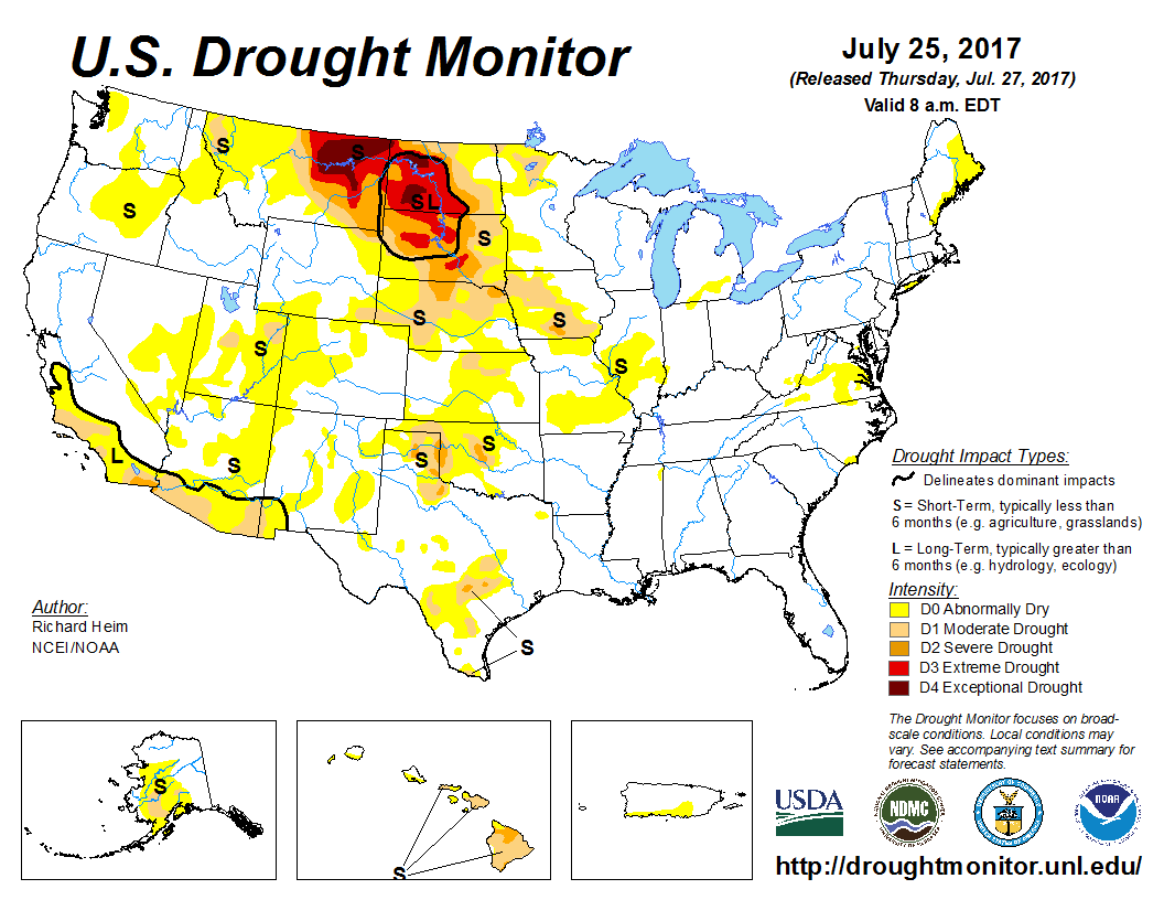
As far as the drought, much of the dry area across the panhandles may be wiped out during this wet period coming up. Farther north, not much luck for the drought hammered northern plains. Even for Iowa things are looking a little bleak at the moment.

I'll see if I can write up something again by the end of next week.
Cheers.
First, the next two images shows the precipitation that has been observed the past 2 weeks, along with the departure from normal. Obviously it has really dried out across a lot of the area, but there is also those areas that continue to be wet.


Looking at the satellite image, there is a relatively strong disturbance (the red X across Nevada) that is going to ride across the big upper high that was in place across Oklahoma. This should help to enhance the overall coverage of showers and thunderstorms, especially Saturday night and Sunday. The pattern will continue to waffle back and forth going into at least the first week of August. This means that there will be a periodic chance for additional rains. At this point, I'm not seeing much indication of the really hot air anytime soon. In fact temperatures in general will be below average for at least a week.

Here is the expected precipitation during the next 7 days.

As far as the drought, much of the dry area across the panhandles may be wiped out during this wet period coming up. Farther north, not much luck for the drought hammered northern plains. Even for Iowa things are looking a little bleak at the moment.

I'll see if I can write up something again by the end of next week.
Cheers.
Subscribe to:
Posts (Atom)