Wednesday, January 25, 2017

1/25/2017 Update

In the previous post I did on the 14th (read it by clicking here), the main focus was on the winter storm that eventually crippled parts of southwest Kansas.  I think you would have to agree that the outlook was spot on in terms of the amount of precipitation and ice (location and amounts).

Ice accumulation (in general) and click for larger map


Liquid equivalent from the storm (click for larger version)
In terms of severity, the storm came no where close as the late December 2006 winter storm.  But, in some areas there was actually more tree damage than in 2006, i.e., in Ford County and Dodge City.  I really feel the severity of the tree damage in this storm was due to the extreme drought centered around 2011 which stressed trees.  Plus, it had been 10 years and the stressed trees had not been trimmed.

Looking ahead....

The afternoon satellite image from the west coast view showed an interesting pattern. (click for a larger version)

The jetstream across the Pacific Ocean basin remains active and strong.  But unlike the past 3 weeks, it is now shifting energy north into Alaska and northern Canada.  There was an upper level ridge centered over western Canada.  Normally this would indicate brutally cold air poised to move into the U.S., but this time there is NOT a powerful upper storm across eastern Canada or the Great Lakes.  There was a storm across Iowa which brought very heavy snow to the Dakotas and into Minnesota, but it is not strong enough to help get the really cold air down into the states.

The pattern for the next week to 10 days will favor a warmup.  There might be a brief cold surge due to the snowpack across the northern plains, but in general look for normal to above normal temperatures, say until about February 4.   As far as precipitation, none to very little should be expected.

Beyond the 4th, the pattern that we had in December should be returning so that cold fronts will become more frequent and more intense.  I think the coldest period will be between February 10 and 24.  There should be a chance that the brutal temperatures that occurred in December will be possible again during that time-frame.  The opportunity for a storm or two should also be increasing.  I will be very surprised if February precipitation ends up below normal across the high plains.  The normal precipitation is not that high so it would take only one good storm. Temperatures should be near normal to a little below (again with a very cold period mixed in).

The Arctic Oscillation would also support that notion of a little colder.  Generally when the index value is positive, the big cold surges are less frequent as pressures are lower than average.  But when the index goes negative and pressures rise, the likelihood of Arctic air into the states is enhanced.  But sometimes the air goes into Europe, Asia and Siberia instead (like it did during the fall).  Forecasts are in grey, and often are not too accurate so we'll see.

A big player in the northern hemisphere pattern has got to be the rapid cooling that has taken place across the northern Pacific since October.

Plus, there really has NOT been a full fledged La Nina like a lot of "experts" claimed was going to happen this winter.  Remember what they said?  Because of La Nina, California was going to continue to have an extreme drought.  LA has had one of it's wettest winters in recent memory. The snowpack in the California Sierra high country is at record levels!

In addition, the Gulf Of Mexico waters continue to be above normal.  This has already impacted the weather at times during the Fall and Winter (Christmas Day tornadoes) and will likely continue to do so as Spring approaches.

As many of you know, I have had a pretty good feeling that going into the growing season and summer that the warm periods will be longer and more intense than they were during 2016.  I also was leaning towards a drier than normal period (on average for most areas).  However, lately my confidence in the drier outlook has decreased a little.  There are conflicting indicators.  There are some that point to at least normal if not above normal precipitation going into the summer.  But there are also indicators that support generally dry weather with increasing drought concerns.  I'm torn right now and just can't say with any confidence.

I need to see how February shakes out.  Plus, I "think" there should be a storm around mid-March.  IF there is indeed a storm around then, and IF it moves across Nebraska and northern Kansas then I might be more inclined to go with that drier outlook (I have reasons).  But, IF it does occur around mid-March and IF it takes a more southern route, I could lean towards a more optimistic outlook.

Stay tuned....(I'll shoot for another post around Feb 1-3)


Saturday, January 14, 2017

Quick update - 01/14/2017

There is a lot to discuss for later in this month and going into February but since I was tied up much of this last week, I will need some time to look at some data.  First things first...

As has been well advertised for the past 6 or 7 days, a potentially crippling storm is STILL headed this way for much of the central plains.  I say STILL because there have been a bunch of folks (primarily down in OKC) that have already (yesterday) poo pooed this storm, well before the expected arrival of the main storm.  There were numerous accidents in Wichita and KC yesterday evening from the first bit of energy that came out.   I'm already hearing grumblings this Saturday morning.  For parts of the high plains it's developing with icing across the panhandles.

This morning the satellite image clearly showed where the storm was.

click for a larger image
The upper part of the system had dropped all the way south off the coast of northern Baja California.  This is serving to tap into tropical moisture (as seen by the green arrow coming up and moving towards the central plains).  This system will NOT lack for surface/mid level/boundary layer moisture.  The big question remains the intensity and duration of freezing rain.  The dashed red line is the projected path of the storm.  Loads of moisture will be lifted over the cold air that is in place.  Speaking of which, the pattern is NOT a cold one.  We got most of all the recent cold (past 3 days) from a huge snowpack that is in place across the northern plains and southern Canada.

I don't recall computer forecast models (not just one) being so consistent in the projected outcome of this storm.  As the upper storm (the red L) gets into the upper balloon network, things may change a bit.  Currently it looks like the bullseye has shifted slightly south. But the amount of moisture that falls across a large chunk of the area will be significant.  Here is one forecast provided by the Weather Prediction Center (WPC) through the upcoming week:

click for a larger version

So, the impacts.  There will definitely be a battle ground between freezing rain and what will eventually be plain ol' rain.  All areas will start out with freezing rain (liquid turning to instant ice as it hits the surface/trees/power lines, etc).  But as the system lifts out towards Oklahoma and Kansas, I think it draws "warm" air north and flips the freezing to above.  But where this ends up is a impossible to say, but most likely from OKC to near KC (and maybe as far west as Wichita).  Just a degree difference will make or break.  There is simply NO way to be accurate with that prediction.  That National Weather Service will stay on top of that so monitor weather.gov and their Facebook and Twitter pages.  The potential exists for 1 inch accumulation or more of clear ice.  Most likely area for this appears to be from like Guymon through Dodge City and to Great Bend and Larned.  But other areas will have extensive ice too.  Significant snow should be limited to areas of east central and northeast Colorado but as storm departs other areas will get just a little snow too, maybe.

Regardless of the amount of ice that accumulates, this will be a very wet system bringing huge amounts of moisture.  Beyond this storm, there is potentially another system that could impact the high plains by the end of the week or next weekend.  If you go back to the satellite image, that potential storm is not showing up but is associated with the system denoted with the red L on the far left hand side.  What produced that storm will produce more.  I need some time to analyze that.  Unfortunately, I'll be pretty busy next week doing three presentations and then will be at the Winter Expo in Dodge City from Friday though Sunday.  I think now through the end of the month will be critical for determining what to expect for the remainder of the winter and going into the growing season.  I'll address that after we get through this period.

Friday, January 6, 2017

Brief update - 01/06/17

In the previous post I did on the 2nd (read it by clicking here), I showed an upper level storm near Washington and Oregon that was going to get cut off from the flow (moving west or southwest) but then would eventually move out into the central U.S..  That particular system was moving by today (Friday) after bringing snow to the high plains (and adjacent areas) yesterday and early this morning.  In Kansas amounts varied quite a bit but in general 2 to 5 inches fell.  Similar or slightly less fell in parts of the Texas Panhandle and across Oklahoma.  Unfortunately there was not a lot of moisture in the snow, but any helps. You can see the position of this system (the red X on the right hand side of the image) on this mornings satellite image (western view)...

click for a large view


Looking at the same satellite image, there was an impressive amount of upper flow across the central and eastern Pacific.  An upper low was over the Gulf of Alaska, but more importantly was the very moist flow meandering across the Pacific Ocean.  The first batch associated with an upper storm was about to slam into California and a second was northwest of Hawaii and will slam into the west late in the weekend or first of next week.  All told there will be feet of rain across much of California and tens of feet of snow in the higher elevation.  It will be highly publicized by our glorious national media (will probably blame it on global warming or climate change).  Good news for that drought stricken state!

Unfortunately for the plains, very little moisture (actually probably zero) will occur as the storms weaken moving into the Rockies.  The reason for the weakening will be the "background" ridge that I've discussed previously in this blog.  This ridge will also help to warm things up dramatically next week.  I'm fairly certain that there will be 60s and perhaps 70s across some areas of the high plains.

But, that warmup will be relatively brief (3 to 5 days) as another surge of Arctic air may ooze into the high plains.  I'm not sold on that just yet but the probability is increasing.

Here is the forecast for precipitation from the Weather Prediction Center for the next 7 days.


I'm going to be strapped for time during this next week.  I'll try and get something put together next Thursday and will discuss the last half of January (which may have an opportunity for another storm and more cold) and into February (that is starting to look pretty wintry).  More on that later.

Monday, January 2, 2017

Back at it....updated 01/02/17

Happy 2017 to all!  My surgery was uneventful and thankfully the issues will require only medication.  Quite a relief.   Since the last post there was definitely some excitement weather-wise!

In that last post I mentioned the T word - as in tornado.  For the first time in our recorded history, there were tornadoes on Christmas Day across Kansas!  In the area that I'm responsible for in the National Weather Service, we had six (6) fast moving and relatively weak tornadoes.  These were not the typical mesocyclone or supercell tornadoes - rather they were QLCS (Quasi-Linear Convective System) tornadoes, or quick spin-ups along the leading edge of a powerful squall line of thunderstorms.  Fortunately there was at least a little rain (some not so much, some as much as 3/4").  It was astonishing for me as a Meteorologist that the dew point Christmas morning reached 60 degrees at my location in Dodge City! It was just absolutely unreal!  Meanwhile across the Dakotas there was a major ice storm and monster blizzard!

Now back to the outlook...

The pattern has returned to a very cold (brutal) one for Eurasia and Sibera and now even across Canada.  The overall jetstream pattern is favorable for this cold to usher into the north central U.S., northern Rockies, parts of the central plains and into the midwest.  BUT, the cold that makes it into the high plains should only be here for a short period of time, as in 3 or 4 days.

First, here were current temperatures (local time)....


Looking at the satellite image, there was one strong storm (that will bring tornadoes to the deep south) moving away from our area.  That is denoted by the red X down in southeast OK.  Another storm (upper level low) was on the Washington and Oregon border area (the red L). 


Another look at the upper low can be seen on the satellite image from a different viewpoint.


Now typically this position of the "L" would be favorable to dive southeast into the at least the central Rockies given the position of the very strong upper level high (the blue H near Alaska).  Given the Arctic airmass that is headed this way, the result for the plains would be at least some snow and opportunities for heavier bands of snow.  BUT (that is a big BUT)....

The upper pattern is screwed up based on a lot of different forcing from various locations in the tropics (and likely higher latitudes).  The low "L" over Washington and Oregon is projected to become cutoff from the flow and drift west!  I think one of the big contributors is the upper flow coming north from the equator region of the eastern Pacific.  That is forcing some weirdness across the norther Pacific. BTW, I will talk about this later this month, but that flow SHOULD NOT BE OCCURRING IF AN LA NINA WAS IN PLACE! (i.e., despite what might have been hearing there is NOT an true La Nina on-going!).

So a BIG forecast challenge will be the eventual evolution and movement of the "L" that will be drifting west.  There is still a pretty good chance that it will impact parts of the high plains IF it moves back east again and into the central U.S. while cold surface air is in place.  That MIGHT occur towards the end of the week.  Thus, I wouldn't be surprised if we get a little snow/wintry mix later in the week.  If it would come out intact and far enough south there could even be some heavy snow across parts of the area. Something to watch.

But cold is a given.  It's the magnitude that is in question for the western high plains.  I think a couple of days with lows approaching zero seem likely.

I'll try and update again towards the end of the week.   By mid-January I'll start tossing ideas and thoughts out about what to expect the remainder of the winter and into the spring. I'm starting to get an idea.

Thursday, December 22, 2016

Quick update - 12/22/16

The brutal Arctic air finally retreated this week.  The coldest reading I saw in Kansas during the cold spell was -27 (yes that is 27 degrees below zero) and that was NOT a wind chill reading.  Many locations observed 18 to 22 below zero.  But now, all that brutal cold air has sloshed back into Eurasia and Siberia, much like it was in November!  I'm betting it will return again this winter!

Here were the current temperatures:


I

In the posts I've done over the past 2 to 3 weeks I discussed two systems for the current period.  The first I thought might move out into the plains around the 22nd, or that would be today.  Indeed there is a system poised to head this way.  It will be weakening as it does move out late tonight and Friday, but it should be strong enough (despite really dry surface air and unfavorable surface conditions) to produce a little rain or light wintry mix later today into early Friday.  It shouldn't be a big deal.

You can see this system on the satellite image:

click for a larger version


In the past 2 to 3 weeks I had also "hinted" at a storm around Christmas.  Well, it does appear that there will be a storm!  But, with the retreat of the Arctic air, any white Christmas snow will end up in the Dakotas!  Such is life in the plains.

In the satellite image, the "developing" system (not yet a storm) is denoted by the blue "M"...

click for a larger version


This developing system (M) should become a vigorous storm as it moves into the western U.S. but it appears that it will move too far north to bring any wintry precipitation to the high plains of Kansas.  BUT, it will likely bring a threat of thunderstorms, at least to eastern Kansas, much of Oklahoma and central and north Texas on Christmas Day!   In the post I did on October 28, I said "I would think the threat of tornadoes across the deep south and perhaps up the Lower Mississippi Valley would surely be higher than normal.  Maybe into Oklahoma and eastern KS?".  

Well, we'll see what happens!

Hopefully the storm will be strong enough to bring at least a brief period of rain or showers to part of the high plains.  I just don't know how far west at this point since the storm has not even developed yet.

Here is the Storm Prediction Centers outlook for severe storms for Christmas Day:


Since I'm headed for surgery, I may not be able to update this blog for a while.

Merry Christmas everyone!

Thursday, December 15, 2016

The Cold and potential for any moisture - update 12/15/2016

I'm sure most of you have NOT enjoyed the cold the plains have been experiencing this past 10 days.  Unfortunately, the coldest air has not occurred yet but is on schedule and will be here very soon.

In the past few posts I had mentioned a "gut" feeling of a storm or precipitation event between the 18th and 22nd.   There is going to be a minor event Saturday (17th) so that would be just a little ahead of schedule, and not that significant as far as snowfall goes.  But what is going to be very impactful is the magnitude of the cold along with wind!

Looking at the satellite image from this afternoon, there were several important features:

Click for a larger map


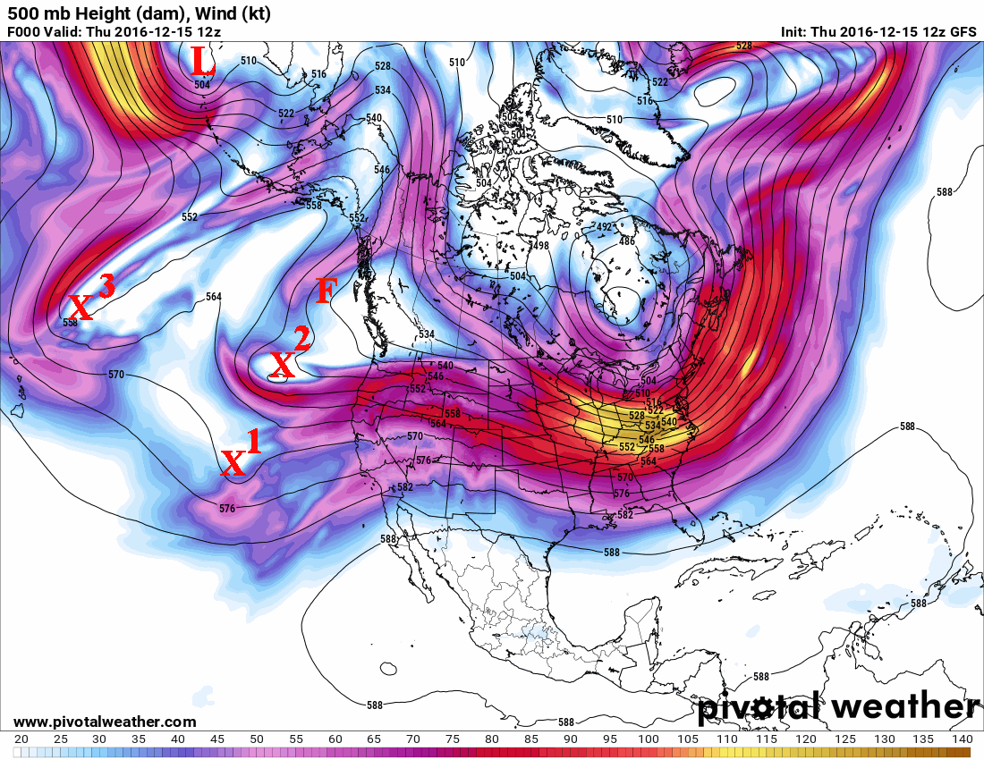
Normally the position of X1 on the map would be ideal to bring a significant storm to the plains.  But this time the flow is rather complicated.  The X2 and X1 will merge into one (maybe), but even if they don't, both will be weakening significantly as they move east and northeast into what I call the "background ridge position".  In other words, the overall pattern is not aligned correctly to allow these systems to retain their amplitude or even intensify.  In addition, the F on the map is a developing system.

BTW, did you ever wonder what  systems denoted on satellite look like on a regular upper level weather map?  The map below shows the level of 500 millibars, or roughly around 18,000 to 22,000 feet.  The solid lines represent a height of the pressure level and in general the wind flow at that level follow these black lines from left to right.  The colors represent the magnitude (speeds) of the wind.


All three systems approaching the central part of the U.S. will interact with a strong gradient of temperatures from the snow packed tundra of the northern plains to relatively warm air across south Texas.  First, the wind machine will crank up across much of Oklahoma and Texas, along with warm temperatures on Friday.  As the systems come out, the surface will be overtaken by Arctic air which will allow temperatures to plunge to values not seen in several years.  Jetstream dynamics will allow for a band of snow to develop in the Arctic air and where ever the energy can consolidate, there may be be a narrow band of relatively moderate snow for several hours.  The snow will be fluffy and will be blown around by the north winds and won't contain much moisture (dry snow).  Temperatures will dramatically fall and even as much as 60 degrees in less than a 12 hour period!  Lows (actual temps - not just wind chill readings) by Sunday morning should be well below zero across the high plains!

Here were the current temperatures across Canada and the northern U.S. at Noon on Thursday. 

The good news is this brutal cold air will move out rather quickly by the first of the week (19th).  But recirculating the cold will result in coldness, just not quite as cold if that makes sense.

You might also be interested in the X3 on the satellite and upper air map.  It was north of Hawaii but instead of moving east and becoming potentially another storm, it appears (according to computer forecast models) as if it will move south and west!  Hmmm.  I need to watch that.

The L (upper level low) west of the Aleutian Island chain will help produce another system that looks like it will drop straight south all the way to the Gulf of California or the Baja.  Now if this happens, eventually it will move east and north and "could" bring some precipitation by the 22nd, give or take a day.  I'll watch that one.

Finally, with the configuration of the upper flow across the north Pacific (including the upper level low west of the Aleutians), that presents an opportunity for perhaps another system around Christmas.  If you remember in that last post, I had a "hunch" of a white Christmas across parts of Nebraska, Kansas (and maybe the panhandles).  But it is WAY TOO early to predict that with any amount of certainty.  What is likely though, is that there will be a significant warm up before Christmas!  More on that as we get closer.

I'll try and update by the 20th.


Saturday, December 10, 2016

Feed bales will be flying - Update 12/10/2016

This is just a quick update on the cold and "potential" for a storm.  On the post I did on the 5th (read it by clicking here), I discussed a system that was dropping southeast out of the far NW and would bring some snow.  After the system went by, the largest amount I saw in the plains was about 4 inches in far north central Kansas.  Light fluffy snow with hardly any moisture content did fall farther south but did nothing to cause problems or unfortunately to benefit soil moisture.  I also discussed the arrival of the cold and the up-and-down that was to be expected for the high plains.  Temperatures have "warmed" up to seasonal values for this current weekend and that will extend into Monday.  But, then the bottom falls out again, and this time it could potentially be even colder than the first surge (I discussed this too and was to be expected).  For a while now I've discussed the brutal cold and snow that had been across the hemisphere (Eurasia and Siberia) and was expected to "slosh" back to this side.  Look at temperatures early this afternoon across Canada!

click for larger map


This is the coldest air so far this season for that part of our hemisphere.   That source region won't change anytime soon.

Looking at the satellite image (click for larger version)...


The red X1 and X2 will move east during the next several days and will unleash more of that cold air across Canada by Tuesday for the central plains.  Hardest hit will be the northern plains and midwest.  But that won't be the only outbreak of cold.  More will be coming later.

In that previous post on the 5th I also mentioned a time frame for perhaps the next potential storm for the high plains.  Despite nothing showing up on the computer forecast models at the time, I had the period from the 18th through 22nd on my mind.  I'm sticking with that period and there is actually something showing up that "might" help that happen!  On the satellite image above, there are two very important features.  One is an anomalously strong and moist flow of air from the deep tropics up across Hawaii and then curving east, slamming into California.  Guess what?  During a La Nina (which the "experts" with the Climate Prediction Center and others have claimed to be going on), this type of flow should NOT exist!  Ha!  More in the coming weeks on this.

Also on the satellite image is the X3.  This appears to be a new system that is just starting to form.  I have a hunch that this particular system just might become a weather maker for the high plains in a week to 10 days.  I'll keep and eye on that and update later in the week.

In the meantime, nothing or very little moisture is expected across the high plains during the next 7 days.  There will likely be fluffy meaningless snow with the cold surges but no impacts are expected.

Here is the Weather Prediction Center's outlook...


Look at how much moisture is expected along the west coast!  WOW!  For the high plains of Kansas through West Texas and eastern New Mexico, as I mentioned, not much if anything.   But maybe there is some hope by next weekend and for the period leading up to Christmas.

The screaming message...a brief "warmup" followed by the deep freeze once again by Tuesday and this should persist for a week or two or three (except maybe a day or two of a brief moderation). At this point it is appearing that average temperatures for December will end up below normal across much of the area.  I'm thinking there will be a lot of breaking of ice and supplemental feeding for livestock.

Also, a gut feeling is for a "white" Christmas for much of Kansas and Nebraska (and maybe even the Texas/Oklahoma Panhandle region. Ha, we'll see how that one goes, i.e. don't tell anyone. ;-)