In the past few posts I had mentioned a "gut" feeling of a storm or precipitation event between the 18th and 22nd. There is going to be a minor event Saturday (17th) so that would be just a little ahead of schedule, and not that significant as far as snowfall goes. But what is going to be very impactful is the magnitude of the cold along with wind!
Looking at the satellite image from this afternoon, there were several important features:
Click for a larger map

Normally the position of X1 on the map would be ideal to bring a significant storm to the plains. But this time the flow is rather complicated. The X2 and X1 will merge into one (maybe), but even if they don't, both will be weakening significantly as they move east and northeast into what I call the "background ridge position". In other words, the overall pattern is not aligned correctly to allow these systems to retain their amplitude or even intensify. In addition, the F on the map is a developing system.
BTW, did you ever wonder what systems denoted on satellite look like on a regular upper level weather map? The map below shows the level of 500 millibars, or roughly around 18,000 to 22,000 feet. The solid lines represent a height of the pressure level and in general the wind flow at that level follow these black lines from left to right. The colors represent the magnitude (speeds) of the wind.
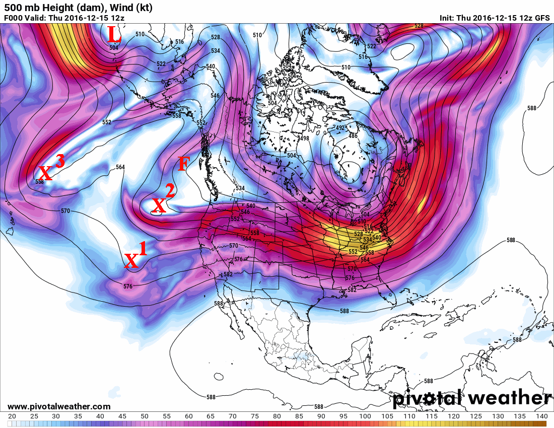
All three systems approaching the central part of the U.S. will interact with a strong gradient of temperatures from the snow packed tundra of the northern plains to relatively warm air across south Texas. First, the wind machine will crank up across much of Oklahoma and Texas, along with warm temperatures on Friday. As the systems come out, the surface will be overtaken by Arctic air which will allow temperatures to plunge to values not seen in several years. Jetstream dynamics will allow for a band of snow to develop in the Arctic air and where ever the energy can consolidate, there may be be a narrow band of relatively moderate snow for several hours. The snow will be fluffy and will be blown around by the north winds and won't contain much moisture (dry snow). Temperatures will dramatically fall and even as much as 60 degrees in less than a 12 hour period! Lows (actual temps - not just wind chill readings) by Sunday morning should be well below zero across the high plains!
Here were the current temperatures across Canada and the northern U.S. at Noon on Thursday.
 The good news is this brutal cold air will move out rather quickly by the first of the week (19th). But recirculating the cold will result in coldness, just not quite as cold if that makes sense.
You might also be interested in the X3 on the satellite and upper air map. It was north of Hawaii but instead of moving east and becoming potentially another storm, it appears (according to computer forecast models) as if it will move south and west! Hmmm. I need to watch that.
The L (upper level low) west of the Aleutian Island chain will help produce another system that looks like it will drop straight south all the way to the Gulf of California or the Baja. Now if this happens, eventually it will move east and north and "could" bring some precipitation by the 22nd, give or take a day. I'll watch that one.
Finally, with the configuration of the upper flow across the north Pacific (including the upper level low west of the Aleutians), that presents an opportunity for perhaps another system around Christmas. If you remember in that last post, I had a "hunch" of a white Christmas across parts of Nebraska, Kansas (and maybe the panhandles). But it is WAY TOO early to predict that with any amount of certainty. What is likely though, is that there will be a significant warm up before Christmas! More on that as we get closer.
I'll try and update by the 20th.
No comments:
Post a Comment