In that last post I mentioned the T word - as in tornado. For the first time in our recorded history, there were tornadoes on Christmas Day across Kansas! In the area that I'm responsible for in the National Weather Service, we had six (6) fast moving and relatively weak tornadoes. These were not the typical mesocyclone or supercell tornadoes - rather they were QLCS (Quasi-Linear Convective System) tornadoes, or quick spin-ups along the leading edge of a powerful squall line of thunderstorms. Fortunately there was at least a little rain (some not so much, some as much as 3/4"). It was astonishing for me as a Meteorologist that the dew point Christmas morning reached 60 degrees at my location in Dodge City! It was just absolutely unreal! Meanwhile across the Dakotas there was a major ice storm and monster blizzard!
Now back to the outlook...
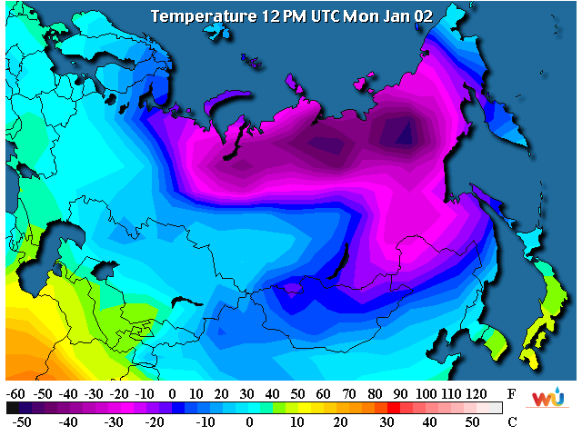
The pattern has returned to a very cold (brutal) one for Eurasia and Sibera and now even across Canada. The overall jetstream pattern is favorable for this cold to usher into the north central U.S., northern Rockies, parts of the central plains and into the midwest. BUT, the cold that makes it into the high plains should only be here for a short period of time, as in 3 or 4 days.
First, here were current temperatures (local time)....
Looking at the satellite image, there was one strong storm (that will bring tornadoes to the deep south) moving away from our area. That is denoted by the red X down in southeast OK. Another storm (upper level low) was on the Washington and Oregon border area (the red L).

Another look at the upper low can be seen on the satellite image from a different viewpoint.

Now typically this position of the "L" would be favorable to dive southeast into the at least the central Rockies given the position of the very strong upper level high (the blue H near Alaska). Given the Arctic airmass that is headed this way, the result for the plains would be at least some snow and opportunities for heavier bands of snow. BUT (that is a big BUT)....
The upper pattern is screwed up based on a lot of different forcing from various locations in the tropics (and likely higher latitudes). The low "L" over Washington and Oregon is projected to become cutoff from the flow and drift west! I think one of the big contributors is the upper flow coming north from the equator region of the eastern Pacific. That is forcing some weirdness across the norther Pacific. BTW, I will talk about this later this month, but that flow SHOULD NOT BE OCCURRING IF AN LA NINA WAS IN PLACE! (i.e., despite what might have been hearing there is NOT an true La Nina on-going!).
So a BIG forecast challenge will be the eventual evolution and movement of the "L" that will be drifting west. There is still a pretty good chance that it will impact parts of the high plains IF it moves back east again and into the central U.S. while cold surface air is in place. That MIGHT occur towards the end of the week. Thus, I wouldn't be surprised if we get a little snow/wintry mix later in the week. If it would come out intact and far enough south there could even be some heavy snow across parts of the area. Something to watch.
But cold is a given. It's the magnitude that is in question for the western high plains. I think a couple of days with lows approaching zero seem likely.
I'll try and update again towards the end of the week. By mid-January I'll start tossing ideas and thoughts out about what to expect the remainder of the winter and into the spring. I'm starting to get an idea.


No comments:
Post a Comment