Friday, July 29, 2022

Rain event was on schedule!

This will have to be very short as I have very pressing issues...

On June 24th (click here) and again on July 14th I mentioned one of the periods I had picked out to have below normal temperatures and above normal rainfall ("July 25-28 cooler again with a above normal rainfall".).  That was amazingly on target although just a few days early.  Here is the rainfall that has occurred this past 72 hours with the majority falling this past 12 hours ending at 11 AM this Friday, the 29th.


Temperatures have moderated accordingly due to the cloud cover and precipitation that will persist through the weekend.

The heat returns next week but it should be moderated by the amount of rain that has fallen (and will continue to fall this weekend). Humidity will likely be a bit higher with the heat.

The next period I had identified (in June and again earlier this month) is:

August 3-7 Below normal temps and above normal rainfall.

The North American Monsoon will continue and hopefully it will slide over again and influence the high plains weather at that point. I'll do my best to post next week but no guarantees.

Thursday, July 14, 2022

Brief update - this is ugly!

In the previous posting I did a week ago on the 7th (click here to read it), I again listed specific dates that I had first posted on June 24.  The period of July 12-18, I posted "July 12-18 A cooling trend with less hot temperatures.  A better than normal chance for thunderstorms, especially July 14-17"  and ended with "It's going to continue to be a struggle for systems to produce widespread rain events.  The North American Monsoon (NAM) has abated a bit (but still going) and let's hope it can regenerate strongly.".

So a little explanation is needed.  The key on precipitation was that last quote, i.e., "it's going to continue to be a struggle for systems to produce widespread rain events".  The cooling did occur, but lasted a whopping 2 days!  That is NOT good!  The 12th and 13th were below normal.  But the remainder of the period is going to be above to much above normal!  That is tied to the expanding upper level high as seen in the upper air map...


That upper high has become very strong, most unfortunately! This will lead to an extended period of very hot temperatures. Those that have missed out on the rains this past 4-6 weeks will suffer the most.

Back to that original post of "A better than normal chance for thunderstorms, especially July 14-17".  The better than normal chance came early with 3 days of thunderstorms on the 11th-13th and because of the expanding upper level high the coverage was dismal.  Here is what fell this past 72 hours....


The North American Monsoon (NAM) has strengthened again but unfortunately has shifted west and too far west to benefit most of the high plains.  But, here is the outlook for precipitation and keep in mind the precip indicated for some of the high plains indicates light amounts...


Hot is here to stay for a while.  In the June posting (and recapped in the July 7th post), I added "July 25-28 cooler again with a above normal rainfall"But keep in mind that it will continue to be a struggle for widespread rainfall.  Essentially there could be 100+ degree temps every day through much of the next two weeks before there is "any" hope of cooling (not that it will be cool by any stretch).   Back in the fall I had made several comments of the similarities to 1956 (the driest year on record at Dodge City).  I'm still holding out on August with some opportunities.  But this might be a run away train at this point so at this time I'm definately not feeling optimistic. 

Thursday, July 7, 2022

Well at least not everyone has been brutally dry!

 In the previous post I did on June 24 (read it here), I put specific periods of opportunities (or not)...

July 4-11  A hotter period with several days, at least, of 100+.  But a few chances of thunderstorms, especially July 7.

July 12-18 A cooling trend with less hot temperatures.  A better than normal chance for thunderstorms, especially July 14-17.

July 25-28 cooler again with a above normal rainfall.

August 3-7 Below normal temps and above normal rainfall.

In between these dates it will likely be HOT and windy!

I was off on the July 7th date by one day as there was pretty good areas of rainfall yesterday (6th).  Even though the following map of rainfall is for a 72 hour period, the majority across the high plains fell yesterday. 


For the past 14 days.....


It's going to continue to be a struggle for systems to produce widespread rain events.  The North American Monsoon (NAM) has abated a bit (but still going) and let's hope it can regenerate strongly.  Colorado and New Mexico have certainly benefited.  Here is the outlook from the Weather Prediction Center through next Thursday (14th)...


I won't be able to update again until at least the 19th...

Friday, June 24, 2022

Well that glimmer worked for some but not others

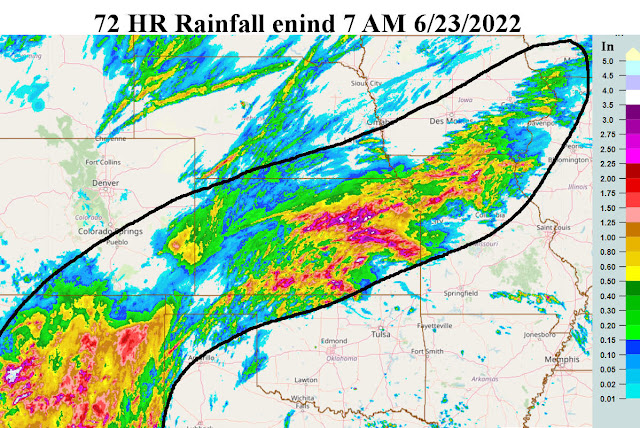
 If you had a chance to read the last posting I did on the 15th (read it here) I discussed the glimmer of hope from the North American Monsoon (NAM) during the summer.  At the time of the posting there was a NAM on-going and the only hope for precipitation across at least the eastern High Plains would be a shift to the east.  That did happen this past 3 or 4 days.  However, astonishing (at least to me) is that some locations got completely hosed (in a bad way i.e., NO Rain or very little).  Here is a map of the rainfall over a 72 hour period ending yesterday (23rd) morning.


Look how some areas got completely missed!  Nine out of 10 times when this shift occurs everyone gets a least a little bit.  


Even late yesterday and last night there was additional rain across much of northern Kansas.

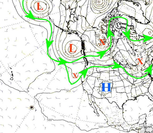
For today the heat has returned with a vengeance, but fortunately it will be very short lived. From the upper air map from yesterday (when I started writing), there was a weak upper system over California which had brought scattered thunderstorms out there.  


However, that system was weakening and moving northeast.  More importantly was the relatively strong upper system moving east out of southwest Canada.  That will unleash some anonymously "cold" air that will race into the central U.S. this weekend.  With any cloud cover and precipitation, highs may only be in the 60s to low 70s!  As far as precipitation with this cooler airmass, much of the influence might be back to the North American Monsoon.  As of yesterday, there was still a narrow corridor of moisture coming up from Mexico.


Hopefully that will interact with the cooler air and produce widespread rainfall.  The focus will likely be south central and southeast Colorado, New Mexico, and into the panhandles of Texas and Oklahoma. There is a lesser chance into far southwest Kansas but hopefully that area will catch it too.  I bet south central Kansas gets it again!

I'm not optimistic for Dodge City though.  Geez, my location has missed about the last dozen events. 

Here is the outlook from the Weather Prediction Center....


Going into August, I have identified some specific dates/periods.  Confidence is not great (given how screwed up this weather pattern is), but at least it's an attempt.  Let's see how it shakes out. Again, confidence is not great.

Per the previous post...

June 26-July 3 For the entire period below normal temps (but a couple  of hotter days mixed in) and normal to above normal rainfall. Specific date June 30 for another complex of storms.

July 4-11  A hotter period with several days, at least, of 100+.  But a few chances of thunderstorms, especially July 7.

July 12-18 A cooling trend with less hot temperatures.  A better than normal chance for thunderstorms, especially July 14-17.

July 25-28 cooler again with a above normal rainfall.

August 3-7 Below normal temps and above normal rainfall.

In between these dates it will likely be HOT and windy!

I won't be able to update again until after the 4th.  Don't blow anything up, especially your fingers!


Wednesday, June 15, 2022

It's looking grim but with one hope

That isn't a very optimistic title to this blog.  Fears of a dry May and June that I had discussed in blog posts during the late winter and early spring are coming to fruition.  The widespread rains a week ago (although not every one benefited) were a blessing and somewhat of a "fluke" in the overall pattern impacting the high plains.  I'm not liking the trend as this may become a run-away-train for the high plains.  In the title "with one hope" appears to be the only chance for a saving grace.  That hope?  The North American Monsoon (NAM).  The NAM has already shown some development and is still set up to become even more active.  You can see that on the upper air chart.


The hope for the high plains is that it shifts periodically eastward at times during the summer.  That certainly does not look to be the case for the near future.  In fact, the upper level ridge (the center of the southeast on the map) looks to expand westward through the weekend and into next week.  That will only exuberate the heat and wind.  I guess that will be good for those lucky ones that have winter wheat to harvest. 

After that wet period earlier in the month, there still has been some rain but really it's been pretty scattered for the high plains with most areas receiving zilch.  Here is a look at what has fallen this past 7 days.


And combine the lack of precipitation this past week with the ridiculous wind combined with hot afternoon temperatures - not a good combination at all. 

The drought monitor was updated just as the last of the heavier rains fell last week and I'm not sure impacts from the rain were incorporated into the drought map.  It doesn't matter....that was short term event whereas the drought is long-term. 


Other than the glimmer of hope for the NAM this summer, I do see a very small chance of a brief pattern change the last few days of June and into the first week of July.  I would bet there were will be some really hot (well over 100 degrees) but hopefully one or two thunderstorms complexes coming off the lee slope of the Rockies, at least for Kansas and Nebraska.  That would also moderate daytime temperatures and increase humidity.  That pattern shift should be temporary.  

Overall I think July will have daily temperatures above normal and precipitation will be below, for most of the area.  August could surprise me.  I've seen late summer shifts that could benefit the area setting up for precipitation into September which would obviously help in the fall planting - and hopefully salvage any warm season crops that may have struggled to survive to that point. 

I'll attempt an update later next week.

Wednesday, June 8, 2022

It rained?

Finally over the hardest hit areas of the drought,  "most" locations got quite a bit of rain this week!  But others?  Not so much.

In the previous post on the 26th of May (click here), I mentioned that there would be a lot of mesoscale processes that would dictate the high plains rainfall chances.  Those processes did occur with several Mesoscale Convective Complexes impacting the high plains.  Initially everything was east of the high plains (as the Elevated Mixed Layer or warm air aloft dominated).  But eventually the MCS's developed far enough east that most of the central high plains got some good rain.  Here is what occurred this past 14 days...


And for the past 72 hours....


One of the hardest hit areas of the region (drought perspective) got some really got amounts.  But, there are still those unlucky ones that, in general, missed out on the heavier amounts (my giant pumpkin growing plots included). 

This blog post will have to be cut short with other obligations to tend to.  Going into mid-June, the heat looks to return with some chances for overnight storms for the high plains, but in general it should be relatively dry.  Again, there will be those lucky and unlucky ones.

For the next 7 days, here is the outlook from the Weather Predication Center....


I'll attempt to update with a look into the remainder of the summer.  Maybe by early next week?

Thursday, May 26, 2022

A good one but not for everyone

In the post I did on the 20th (read it here) I discussed the "glimmer of hope" that would be possible in May.  We got two of those glimmers, but really only benefited from this last one.  On the 20th there was an upper system WAY out in the Pacific and it had a long way to go to get in an ideal position to bring what appeared to be a pretty decent chance for widespread precipitation for this week.  Indeed the system did impact the high plains (and much of the central U.S.) with widespread rainfall.  Some got way more than expected, others fell short once again.  It's the way it is with weather.  Here is a map of rainfall the past 72 hours...


and a little bit of a close-up of the high plains...


I ended that last post with "But, then beyond mid-week, it looks dismal again.  What the atmosphere will be fighting is a very warm Elevated Mixed Layer (EML) or capping with warm air aloft.  I'm afraid going forward that it will have to be a case of good luck to get mesoscale processes lined up to produce opportunities for rainfall. "

Which brings us to the latest upper level map...


The departing storm that brought all the rain was located over southwest Missouri this morning but had loosened it's grip on the high plains.  Now attention is drawn to the jetstream over the Pacific.  The pattern will be active going into June for the northern plains initially but then down into the southern plains.  As I mentioned in that quote above, most of the high plains region will be fighting the warm air aloft (capping).  Surface and boundary layer moisture will be making a return but the main questions will be how far west the moisture can get and if the air aloft will be too warm to prevent thunderstorms.  Again, as mentioned, it will probably boil down to mesoscale processes (small scale features and interactions with overnight storms later in the week) that will spell doom or gloom in regards to precipitation.  Some of the models and official NWS forecasts are someone robust in the output.  Here is the latest map of possible precipitation amounts from this Thursday afternoon into the start of the next weekend....


It will be a day-to-day type of situation.  The first opportunity for the Kansas region of the high plains may be as early as Monday of this next week with several opportunities throughout the week.  I'm afraid to get too excited as this last system may have gotten some hopes up.   For the eastern part of the high plains, yeah it sure looks good (and many may actually have gotten too much rain so far).  But I just have a sneaking suspicion that the warm air aloft may win out on most days for the high plains.  Again, it will be these mesoscale processes that might call the shots.  Fingers crossed. 

I still intend to address the remainder of the summer in later posts...