Monday, January 31, 2022

Here we go again - on several levels

If you didn't get to see the brief posting I did on the 24th, you can read it here.  Actually please do read that submission.   In that post I discussed the large range of possibilities of snowfall amounts that were expected with the upcoming storm.  Forecasting snow totals is a complete WAG as there are so many unknowns.  The storm in question definitely produced banded snowfall as I expected.  But for that main band to produce 18-24 inches is WAY off the charts!  There is simply no way to expect that type of snow generation from any storm.  

I've mentioned in several presentations I've done that snow making by the atmosphere is highly dependent on many variables, but is REALLY impacted the greatest by what is called the dendritic growth zone.  If there is solid ascent (rising) of the air in this zone (between -12 and -18 deg Celsius) with ample moisture (saturated air), then heavy snow can develop.  But typically this growth only last several hours and the zone of growth moves around.  During banded events, the snow can become intense and then when these bands remain stationary the amounts add up fast, such as what happened on the 25th.   

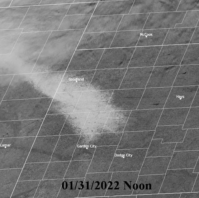
The band of very heavy snow (greater than 18 inches) was no more than 10 miles wide but the area of amounts greater than 10 inches was a bit wider.  The day after the satellite image showed the snow field...


Even as of this morning (31st and 6 days later) you can see how much was still around!

Different topic....

My extreme pet peeve....FAKE WEATHER!   There are so many people that post graphics and pretend to be Meteorologists and SO many people that follow them (and then often share the crap that is displayed).  I talk about it in every presentation I do.  The latest example from a few days ago by a Facebook poster that TOO MANY people follow him/her....  here was that post....


This one REALLY ticked me off because people I know started sharing it.   In reality, lows up in the Dakota's and Minnesota might get as cold as -30.  Typical for most winters up there.  This person also indicated 2 feet of snow across Nebraska and Iowa.  They might not even get a dusting.   This type of fear mongering goes on way to much in social media.  

 Off my soap box.

I still need to do more analyzing before I venture into the spring and summer outlook.  For now we'll be dealing with another storm, unlike last Tuesday but impactful just the same across a much larger area.  Just like the last event, computer forecast models are pretty useless.  Look at the outlook from various models for Dodge City as an example.  A dusting to 12 inches!  


Look at Kansas City....3" to 25"!  


Come on...are you serious?  This time the actual track of the upper storm will be most critical, plus a big question is will the storm come out in pieces (less snow) or be more concentrated?  Given the lift of moisture across Texas up and over the increasingly cold airmass with at least some upper level forcing, I think a large area of 4 or more inches can be expected across the high plains of Kansas, Colorado and into the panhandles and points east. I'm sure there will be pockets of 6 plus.  Actual moisture content may end up between 1/4 and 1/2 inch but the snow will blow around.

After this event, it appears we might be going back into a drier trend and eventually much warmer once the snow melts.  I'll see if I can finetune that outlook and dig into the later winter and spring outlook in the next posting.


Monday, January 24, 2022

Brief update - Jan 24, 2022

 Before I get into the meat of the outlook for the spring-summer-end of the growing season, I'll need a bit more time to do some more analyzing.  The picture is becoming a bit more clear but I need to look a bit more data.  

I thought I'd just briefly mention some of the difficulties in making a "short term" forecast for the high plains.  Take this upcoming event as an example.  Looking at the upper air chart this morning...


A disturbance in the upper atmosphere over southwest Canada was moving south-southeast this morning  It is expected to intensify as it drops south before turning east.  Forecasts being made for the expected surface weather across the high plains for tomorrow (Tuesday) and into Wednesday will have to settle in on several assumptions, some assumptions that won't verify.  

1) Will the system take a track as indicated by the red line?

2) Will the system continue to intensify as it drops south?

3) What will the impacts be if the system turns east more quickly, or even later and farther south?

4) What will the moisture profile be like to feed this system?

5) What will the ice crystal and eventual snowflake temperature profile be like - all dependent on the growth zone of the ice crystals.

It is certain (100 percent) that this system WILL produce an area of snow across the high plains.  But what will the areal extent be (how far east) and coming up with an amount for any one location (both snowfall and moisture content) is purely speculation and a WAG.   You might ask, "won't computer forecast models help out since the event is less that 24 hours away?"   Ha!  Look at what the various computer forecast models have for Dodge City.  That is a range from a dusting to almost 8 inches!  Ridiculous! 


The same extreme variance is indicated for other locations.  Since this system is likely to produce banded snowfall, there should be NO confidence until the snow actually starts to develop and the upper system has made it's turn.  That means that the lead time with confidence may only be hours.  It's the way it is with forecasting sometimes.

That leads me to the outlook for the growing season.  If there is this much difficulty with just one minor weather system, how can forecasts months and seasons in advance have any validity?  It's tough!

What I try to do is pick out periods of opportunity.  For instance, in my last post I did on the 12th, I said "Other than a few days of possible precipitation with the cold air later this month, I'm afraid that February may follow January with several outbreaks of cold but with not many chances for precipitation = maybe just a couple."  This storm for tomorrow may be it for the balance of the month. Another shot of cold or two so nothing mild or warm is expected.  There is "some" hint of changes for that first week of February and I'll address that on the next blog posting (hoping to do that before the end of the month).

But for now, let's hope this system brings at least a small gift for many of us.  Those that get under the bands will benefit the most and may get up to 1/2 inch of moisture in the snow.  Others it should be under 1/4 of an inch, but at least it's something.

Wednesday, January 12, 2022

Pathetic weather continues unabated - Part 2

Since the last posting on the 23rd of December (you can see that here), there was at least a little bit of precipitation - an actually a fair amount for select areas (all things considered for the winter time).  Two separate snow events (Jan 1 and Jan 6) dumped 6 to 10 inches on an area of western Kansas.  A satellite image from Monday shows what is left (the bright area was the heaviest)....


Unfortunately, most of us had less than 1 to 4 inches and the snow was accompanied by wind.  The snow really wasn't as dry as might be expected but it really did not help with the drought situation (other than that small area noted above).

Instead of posting the drought map as I usually do (which takes into consideration hydrologic data - not just precipitation), I'm posting the Palmer Drought Index which can be more representative of soil moisture in addition to precipitation deficits.


The pattern is cycling, just like it does every year, but I'm having a difficult time discerning the actual time scale.  I see evidence of 41 to 44 days but also as long as 82 days.  There was some thought too of around 60-65 days but I'm just not seeing it at this point.  Regardless, it is a really awful pattern as far as getting a decent amount of moisture.  There is hope for spring but I'm afraid that the pattern will yield the best chance farther east.  For the high plains that would equate to some really windy, warm and dirt storm days, much like occurred December 15.  I'm not ready to panic on the March through May period just yet - so hold on.

In the near term, there will be an impactful storm at the end of the week but it will not bring much if anything to the high plains, other than another bout of high wind and brief colder temperatures. Looking at the jetstream map....


The big red X off the northwest U.S. coast is the storm that will take the track as indicated by the red dashed line.  It will be referred to an Alberta Clipper (common winter type storms).  It will then tap into the Gulf and become a MAJOR winter storm for the eastern part of the country over the weekend.  They will get pounded!  

Any hope for something for the high plains may come with the next shot of really cold air and that is due around January 22, give or take a few days.  I see strong possibilities of a 2 to 4 day period of much below normal temperatures.  Details this far out are unknown, but I would think it will be at least as cold as it was the first few days of this month, i.e., a couple of days of sub zero temperatures (highs in the single digits).  The good news is that the cold stretch should not be prolonged.    With that cold air, I see a pretty good chance of some precipitation - likely in the form of frozen.  But unfortunately, it probably won't be a huge amount but I guess anything would be good at this point.

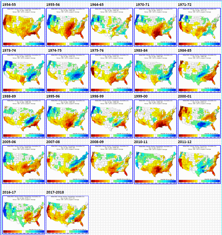
So is this awful pattern the result of La Nina that I'm sure everyone has heard about?  I've said it before.  La Nina or El Nino only "contributes" to the pattern.  We are in a pretty good La Nina at the current time.  But to make a forecast based on that?  Look at what has happened during past La Nina events.  No two are alike and we often see a wide range of weather across the high plains during each one.  

Here is the anomaly of precipitation during La Nina events (November through March)...


Here is the anomaly of temperatures during La Nina events (November through March)...


So with the vast differences from one to another, how can one make an accurate predication of what is to be expected based on La Nina (or El Nino)?  

The current sea surface anomaly has this....


The cooler than average (La Nina event) definitely is notable from south America west along the equator.  But what about that warm blob across the north Pacific?  What about that cool area in the gulf of Alaska?  That may or may not have an impact.  Believe it or not, the northwest Atlantic warmer than normal waters may also be having an affect.

One huge concern I have is the above normal waters in Gulf of Mexico.  There will likely NOT be major intrusions of Arctic air into the gulf this winter (maybe very briefly).  Thus, I suspect that waters there will be very warm as spring approaches.  I already mentioned in posts this past fall that the pattern was set up for above normal tornadoes for Kansas for 2022.  I'm not completely sold on western Kansas but eastern Kansas (and points north and south) will likely be under the gun several times.  This warm gulf will be the source for the rich moisture needed.  Hopefully though, this would also equate to a potential source for moisture for some of the high plains if a weather system can get going west of us.  More on that later....

So, going forward.  Other than a few days of possible precipitation with the cold air later this month, I'm afraid that February may follow January with several outbreaks of cold but with not many chances for precipitation = maybe just a couple.  Fingers crossed.  As March arrives, perhaps there will be an improved chance for beneficial precipitation, but I'm not getting my hopes up for now.

Next week (Tuesday and Wednesday, 18th-19th) I'll be presenting at the Cover Your Acres Winter Conference   in Oberlin.  Perhaps I'll see a few of you there. 


Thursday, December 23, 2021

Pathetic weather continues unabated

 I'm now pretty confident of the cycle length of this years weather pattern which started setting up in early October.  Results of sensible weather (what to expect for you and me) will be different during the fall and spring verse the driest part of the year - Winter.  It is still unknown what part of the weather regime across the northern hemisphere is "forcing" the pattern itself, and what if any changes will occur going forward.

I'm sure most of you have heard that we are in a second, back-to-back La Nina pattern and it is actually bordering on a moderate event.  Looking at composites of previous La Nina winters from history does not support what is going on across the west, especially the southwest part of the country.  For the high plains of Texas, Kansas and Nebraska (and of course eastern Colorado), the composites of years past have been all over the board from wet to dry and from cold to warm.  Obviously at this point our region has been in the "warm and dry".  Will this continue?  If only I knew but unfortunately question is very complicated.

Recently I believe the Madden Julian Oscillations (MJO) has been calling the shots.  A fairly robust MJO across the western Pacific (phase space 7) has stalled.  Looking at composites of previous MJO events across the that part of the globe for December has yielded dry but increasingly cold.  Here is a look at the current chart of where the MJO is and where it is expected to go....

In that previous post (click here) I had mentioned the brutal winter conditions that had been stuck across the other side of the hemisphere (Siberia and Europe primarily).  A severe energy crisis is ongoing in that part of the world.  In that previous posting I saw hints that some of this cold could impact our area late December into early January.  That seems plausible as the MJO location is favorable and the Arctic Oscillation Index has gone sharply negative (usually when this happens cold is dislodged towards the equator).   This morning some really cold air was in place across Canada.


Based on the cycling nature of the weather pattern, any really cold air that moves into the high plains might not last too long (a week to 10 days).  Again, the target date is the last few days of December and into the first week of January.

As far as significant precipitation - at this point for the high plains it does not look favorable.  Yes, there could be some with the cold air but I'm afraid that anything meaningful may not materialize.  I'll address that later.  We could really use something.  For the past 60 days, here is a look at how much has fallen - or not even occurred.


And as many are aware, this dryness this past 60 days has contributed to the drought conditions (and it happens more slowly during the dry winter months...


The jetstream as indicated on this map....


...is in a perfect position to bring wetness to the western U.S., including the arid southwest and into the Colorado Rockies, but is NOT favorable to bring meaningful precipitation to the high plains.  The pattern is just too far west and too progressive (systems are moving across the central U.S. too quickly to draw up moisture).

So, for January and February, at this point, I don't see a really wet pattern developing.  We might get lucky with a storm or two close enough and slow enough to bring at least something.  But enough to make a dent into the drought just doesn't seem to be in the cards.  This will be REALLY bad for fire concerns as there will be those periodic systems with a lot of wind and unfortunately there is a lot of fuel (grasses) present. 

As another cycle of this weather pattern transpires, I hope to have a little more confidence going forward.  More later...


Friday, December 10, 2021

This is complicated and where did my post go?

I went back to look at the previous post I did on December 1st and I can't find it!  Well crud - I bet I didn't save or publish. So - it's been a while.  On that last actual posting on the 19th (Nov), the theme was trying to figure out the cycle length of the newly developed weather pattern and impacts.  I'm puzzled.  This one is not easy to analyze (well it never is, but some years it's a bit more clear).  Last year the pattern was reoccurring somewhere between 45 and 47 days.  This year it may be much longer!  There are conflicting signals.

For those that may be relatively new to this blog...

Weather patterns that exist and cause various types of weather across the high plains, develop and establish every fall and every year are different from the previous year.  The results can be the same, but the actual pattern that produces the weather will be different.  Unfortunately for the high plains, weather is heavily influenced by the big rock pile to the west (Rocky Mountains) and influenced by the availability of gulf moisture.  Geographically the high plains is located in a semi-arid region (some years wet, some very dry, others in between).  Look at variability of yearly precipitation (in this case Dodge City)....


There is tremendous variability from year-to-year, let along variability on a very small scale with regards to precipitation patterns even when a weather regime is similar (not the same though).

I've been to several meetings this past month and have hinted pretty hard that December could turn out pretty cold but that was based on a hunch and analysis of where the early buildup was occurring.  The airmasses that would support a cold December have definitely been in place, but on the other side of the hemisphere!  

I'm sure some of you have heard news reports (if they can believed - I know it's hard).  The ice build-up at the higher latitudes oceans and waterways was strong and early.  See my last post I did (that was published) back in November at https://swkswx.blogspot.com/2021/11/uncertainty-is-high-and-is-real-cold.html.  Europe and Siberia have been hit particularly hard with the cold that has now produced some energy shortages - ALLREADY!  But why hasn't that cold been displaced towards our neck of the woods?  Well, to get that to happen the atmospheric river of air above us (the jetstream) will have to become oriented in such a way to deliver the cold south into North America.  Very recently the cold has spilled across the eastern Pacific.  The higher elevations of Hawaii was hit hard with blizzard conditions while the lower elevations got pounded by excessive rainfall. 

A slight shift in the flow was now occurring producing an onslaught of rain and snow due for the western U.S., and finally some decent snows for the Rockies. Look at how much precipitation is expected during this next 7 days (through the 17th)....


This similar situation occurred around mid-October.  Unfortunately that is a lot of "white" of no precipitation for the central and southern high plains.  The weather system moving through today (Friday) and the one during the middle part of next week will produce nothing but WIND.  

So is there any hope for precipitation beyond this period?  Computer models that go out a ways, and often with many errors, are all over the place.  Most of them keep the weather dry with little to nothing and some even keep it dry on through all of  December! However, every couple of days, one or two "hint" at some decent precipitation.  Those infrequent computer "runs" that have precipitation just might be the reason that some recent outlook maps from the Climate Prediction Center look similar to this...


No one should get excited by this.  First, this is a probability of leaning towards above normal precipitation.  It doesn't imply a "lot", just that the odds have been shifted towards the above category.  Anything would be nice at this point.  Again, computer forecast models have been all over the board with the majority pointing towards continued dry.  However, looking at the cycle length of returning weather systems, I do see at least a small chance (at this point) of something between December 18 and 21.  That would simply be a "finger crosser" for now.  A lot of changes would need to take place first so I'm not terribly optimistic, but still slightly hopeful.  If that doesn't pan out, it doesn't look too good going into the first of the year.

As for really cold air?  Yeah there is some hint for later this month and into the first week of January but I need to analyze that length of returning systems.  I'm kind of fearing that the ocean temperatures of the equatorial Pacific may be the biggest contributor of the current weather pattern across the Northern Hemisphere.  Why would I fear that?  Because of similarites from the past.  In example, the fall and winter of 2009.   I'll address that in the next posting - and I'm going to attempt to do that next week.


Friday, November 19, 2021

Uncertainty is high and is the REAL cold weather too far away?

With the new weather pattern showing several different "clues", I'm getting closer to getting an understanding about the set up for this winter and what will carry into 2022.  I need another week to analyze the upper air pattern across the northern hemisphere.  There may be a big of indication that the repeating of features may be starting (or it may be another week to go).  I hesitate to make much of a prediction at this time. 

Back in late October I was seeing some forcing and subtle indications that a pattern change could occur during Thanksgiving week.  Of course that far out it timing down to a few days was impossible (or at least just throwing something against the wall to see if it would stick).  I had enough information, or at least a gut feeling, that the Thanksgiving week would be at least colder but with the possibility of an impactful storm at least within a days travel of central Kansas.  Computer forecast models this past week have been all over the place from very dry to a significant storm, but heavily leaning towards very dry. 

Looking at this mornings upper air chart....


 So far the upper air pattern has not been favorable for an significant and prolonged intrusion of cold air into the states.  There is a northern jet stream that has not "buckled" or amplified - yet.

There has been bitter cold air building across the higher latitudes of the northern hemisphere since October, just waiting for an excuse to surge south into lower latitudes.  So far, it appears parts of Europe have been hit the hardest with there ALREADY being natural gas shortages.  That is NOT a good sign as I fear the same may eventually occur across the U.S. this winter.  I have been mentioning that December could be below normal on temperatures.  Yet, long range outlooks and computer forecast models have been indicating exactly the opposite.  Another indication of this buildup of very cold air can be gathered from just this headline (about the Arctic)...


And the cold persists....look at the temperatures as of this early Friday evening (19th)...


That's a pretty big area of below zero air!  So, when will it surge south and when it does will it move into the U.S., or will it travel into Siberia and Europe?  Unfortunately, I really don't have a feeling one way or another, at least for now.  Again, I need another 10 days or so to analyze this pattern.

A couple of things that have caught my eye though....one is the North Atlantic Oscillation has it has gone negative and is expected to bottom out significantly negative.


That would promote an amplification of the upper air which "could" lead to that intrusion south.  And at the same time the Arctic Oscillation index has been trending negative which would also promote a southward movement.


Even with much colder air for a few days around Thanksgiving, the "real" push of cold into the states (including the high plains) is looking more and more likely during late November or early December.  I hope to refine that thought in the next blog posting.

As far as precipitation, at this point, it's looking fairly scarce for the high plains.  I think any storm development around Thanksgiving may favor the southern high plains and into the Ark-la-tex region but check your local weather sources as we get closer to mid-week.  Or - I just might get a chance to update by then.

And to end this posting - I'm sure this map is no surprise to anyone...


Unfortunately this stretch of dry weather for the high plains is one of the parts of the pattern that will return during the winter, spring and into summer.

Thursday, November 4, 2021

"Early Winter" will be making a retreat

The advertised cold that persisted this week is starting to retreat, as it should this time of the fall.  The lowest temperatures with this event fell into the middle 20s across many areas of high plains, with just about every location reaching at least freezing.  This morning (Thursday) the coldest reading I saw was 24 at several locations, but I'd bet there were colder temperatures in preferred lower lying areas.  The advertised precipitation this week fell as mainly liquid although there were occasional bursts of sleet and wet snow.  Here is a map of precipitation, which where it did fall was actually a bit higher than expected....


Now it appears the pattern will go back into the expected drier regime for the high plains, and initially much warmer.  There will be another cold front early next week but it won't be too cold, just not as warm.  Later in the week another cold shot will arrive and it should get as at least as cold as this weeks.  At this point there is NO indication of a wet storm through at least the first part of Thanksgiving week.

This mornings upper air chart...


The stage is starting to set up for a build up of very cold air across the higher latitudes of Siberia and higher latitudes of Europe.  It will likely be a while before that is unleashed into the lower latitudes.  There has been a strong hint of this happening around Thanksgiving but at this point it could occur across the eastern U.S., or even stay across the "other side".  Any precipitation of significant should stay way out west and also east of the high plains, at least until at least Thanksgiving week.  Of course, the pattern is still in the formative stage so a "surprise" pattern shift is still possible.   

As far as a winter outlook, I'm holding off just a bit longer to access the early stages of this new pattern. There are already forecasts in place by various sources but those are based on the fact that La Nina is in place.  As I'll show in the next posting, the average weather (both temps and precip) has been extremely variable in those La Nina winters.  More next time....

The outlook from the Weather Prediction Center through next Thursday....