If you didn't get to see the brief posting I did on the 24th, you can read it here. Actually please do read that submission. In that post I discussed the large range of possibilities of snowfall amounts that were expected with the upcoming storm. Forecasting snow totals is a complete WAG as there are so many unknowns. The storm in question definitely produced banded snowfall as I expected. But for that main band to produce 18-24 inches is WAY off the charts! There is simply no way to expect that type of snow generation from any storm.
I've mentioned in several presentations I've done that snow making by the atmosphere is highly dependent on many variables, but is REALLY impacted the greatest by what is called the dendritic growth zone. If there is solid ascent (rising) of the air in this zone (between -12 and -18 deg Celsius) with ample moisture (saturated air), then heavy snow can develop. But typically this growth only last several hours and the zone of growth moves around. During banded events, the snow can become intense and then when these bands remain stationary the amounts add up fast, such as what happened on the 25th.
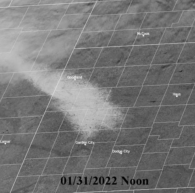
The band of very heavy snow (greater than 18 inches) was no more than 10 miles wide but the area of amounts greater than 10 inches was a bit wider. The day after the satellite image showed the snow field...
Even as of this morning (31st and 6 days later) you can see how much was still around!
Different topic....
My extreme pet peeve....FAKE WEATHER! There are so many people that post graphics and pretend to be Meteorologists and SO many people that follow them (and then often share the crap that is displayed). I talk about it in every presentation I do. The latest example from a few days ago by a Facebook poster that TOO MANY people follow him/her.... here was that post....
This one REALLY ticked me off because people I know started sharing it. In reality, lows up in the Dakota's and Minnesota might get as cold as -30. Typical for most winters up there. This person also indicated 2 feet of snow across Nebraska and Iowa. They might not even get a dusting. This type of fear mongering goes on way to much in social media.
Off my soap box.
I still need to do more analyzing before I venture into the spring and summer outlook. For now we'll be dealing with another storm, unlike last Tuesday but impactful just the same across a much larger area. Just like the last event, computer forecast models are pretty useless. Look at the outlook from various models for Dodge City as an example. A dusting to 12 inches!
Look at Kansas City....3" to 25"!
Come on...are you serious? This time the actual track of the upper storm will be most critical, plus a big question is will the storm come out in pieces (less snow) or be more concentrated? Given the lift of moisture across Texas up and over the increasingly cold airmass with at least some upper level forcing, I think a large area of 4 or more inches can be expected across the high plains of Kansas, Colorado and into the panhandles and points east. I'm sure there will be pockets of 6 plus. Actual moisture content may end up between 1/4 and 1/2 inch but the snow will blow around.


No comments:
Post a Comment