Friday, December 9, 2022

The pattern may be set

In the previous post on 11/23/22 (read it by clicking here) the headline was "another swing and a miss?".  I also discussed that this year's pattern was not quite set, or so it would appear.  With the system this week (southeast of the area across mainly Oklahoma but a secondary moving well north) and the system moving by this Friday night and Saturday (again mainly southeast of the area), I believe I have a pretty good idea of the nature of the pattern.  Is it concerning that much of the high plains has been left high and dry?  Absolutely.  But with the changing of the seasons (fall into winter, winter into spring, and spring into summer), the pattern will shift around enough that it won't be totally gloom and doom.  Now to time it.

The system(s) the past 2 days brought good moisture to Oklahoma again (and into the Corn Belt).  Here is a map of that precipitation. 


During the past 2 weeks there was "some" precipitation farther into the plains, but not a lot.


The biggest weather news this next week will be a monster storm that is going to impact much of the central part of the country with a blizzard across Nebraska and the Dakotas and severe convective weather farther south and east.  There will be a big concern for a possible outbreak of tornadoes across the Mississippi Valley.  For the high plains (at least the central and southern high plains), it looks like more of the same with dry and way too much wind.  But....

In the past few meetings and presentations that I have been doing, I mentioned the second half of December could be active and very cold.  I've expected this for several weeks because of some connections to the tropics with the higher latitudes; possible blocking of the jetstream;, and a buildup of snowcover across the northern hemisphere. One thing I look at in a shorter time frame (less than 30 days) is the indices of the Arctic Oscillation and the North Atlantic Oscillation. 


It's not unusual for these indices to go strongly negative.  When the Arctic Oscillation goes strongly negative, it is often followed by a deep intrusion of Arctic air into lower latitudes.  Sometimes it's across Europe or Eurasia and sometimes into North America.  It just depends.  When the North Atlantic Oscillation goes deeply negative, there is usually blocking of the jetstream across the Atlantic and into Greenland.  When this happens weather systems tend to slow down and move more meridional. But, when both the AO and NAO go negative, there is quite often a major intrusion of Arctic air into North America, including the U.S..  That is one clue that December is about to get frigid.  Then top it off with the snow that has built up across the northern hemisphere...


BTW, that area of snow cover across the northern hemisphere had been above record levels and still is above the 56 year mean.  Interesting. 

With all this going on and with the pattern that is setting up, the jet stream flow is going to become (or has become) very energetic and volatile.   After this major storm moves by early next week, the remainder of December will, on average, be colder than normal with periodic episodes of snow (including snowfall for the high plains).  The way I see it, many locations across the central and northern U.S., will have a white Christmas or at least the odds favor such.

As far as precipitation, here is what the Weather Prediction Center is expecting through the end of next week.


That is definately a concerning image for the central and southern high plains, especially knowing that there is going to be more wind.  The periodic snow I'm expecting towards the end of the month will help a little.  I would expect those opportunities to repeat a couple of times going into spring.  

My gut feeling going farther into 2023?  It will be a “normal” winter, active spring and probably a dry and hot summer – all subject to updates as the pattern becomes evident.  

With me wrapping up my career in Meteorology with the NWS, I'm not having much time to update this blog but I will attempt to do so again next week.  As mentioned, a month ago or so, changes will be coming to this blog.  More later.


Wednesday, November 23, 2022

Another swing and a miss?

Before I get into the woods....here is the system precipitation that impacted some of the area with rain and snow on the 14th.  At least it was something.


Another strong storm will impact the southern High Plains this holiday but largely miss the central and northern parts of the HP.  This sign is both discouraging but encouraging.  Why encouraging?  Because the atmosphere is capable of intensifying storms "nearby". 

Looking at this morning's upper air map


An intensifying and strong upper system over Wyoming was dropping south.  Unfortunately for much of the high plains of Kansas/Nebraska it will "dig" way too much to benefit much of our area.  It will, however, likely bring very heavy precipitation to west Texas (and some of the panhandle) into Oklahoma.  Some of this will be very heavy snowfall too.  This will be the 3rd or 4th time this fall that a system has behaved in this manner.  That "could" benefit the rest of us later this winter and into the spring.  More on this in later posts. 

The exact track and behavior of this system is still unknown, even though it's 24 hours away!  These types of developing and intensifying systems are just plain unpredictable in terms of location and specifics

Computer models will be ALL OVER THE PLACE!  This leads me into a topic that I have discussed numerous times.  Social Media is a platform that misinformation will be shared routinely.  Computer models struggle mightily.  Here is an example of a computer model solution generated on 11/15 and valid for this week (ending Saturday).


Look at those ridiculous snowfall amounts!  And the placement (WAY OFF).  Just 6 hours later when the same forecast model generated data for the same period, this is what it was showing.  


This type of behavior is not unusual.  The models forecasting many days out just can't be trusted.

In later posts I'll do late next week or the following week, I will dive into the outlook going into spring.  I'm starting to see signs that the first cycle of this year's pattern is about to be set.  I should know more in a couple of weeks or three.


Friday, November 4, 2022

Is there any hope?

The title - of course there is.  All dry periods (droughts too) are broken.  But how much can we endure before favorable weather returns?  In previous posts going back a long way, I had pointed out numerous times that, for instance, Dodge City experienced 7 years in a row (2014-2020) of above normal precipitation.  It was almost 9 in a row as 2013 and 2021 were just a little bit below the annual average.  From 1875 through the current time, there had never been more than 3 years in a row.  So, this was highly anomalous to have that many "wet" years in a row.  The pendulum was going to swing the other way, there was no doubt about it.

Remember, the high plains region is considered to be semi-arid and the farther west towards the front range (from New Mexico into Canada), the more likely it is that the year or season will be dry.  That is just a fact of life.  Even with dry years (or seasons), crops have been raised without irrigation.  Obviously, production will be limited in many cases (depending on the environmental conditions during the growing season). This year and season have been brutal for many.  Will it continue into 2023?  I wish it was easy to say one or other but there are just so many factors/issues that influence sensible weather, especially across the high plains.

In the previous post I did on October 28 (read it by clicking here), I discussed again about the new weather pattern that was setting up.  The new pattern then and as it is today (the 4th of Nov) was and is still young.  I have been mostly discouraged but yet there had been and continue to be at least a few signs of promise.  The last one is the system that is moving out of the Texas Panhandle today.  Overnight there was a fairly large area of rainfall and here is a map of what had fallen as of 9 AM this Friday morning...


Granted, many of the areas hardest hit by the drought and dryness had largely missed out, AGAIN! But the system was still likely to produce at least some rainfall (and snow) farther west.  This type of strong system will make more appearances later this fall and winter.  Even though not all areas got or will get precipitation, the evolution of the system is slightly encouraging.

Speaking of precipitation, the October amount was awful.  Dodge City (airport) got just a trace, and this has happened only 2 other times in recorded weather history (back to October 1874).   


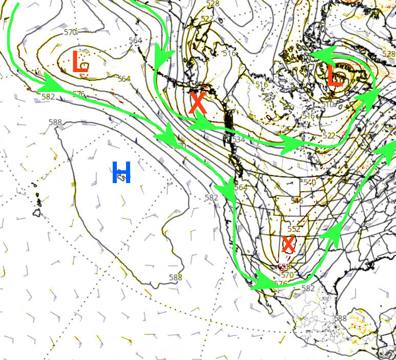
As of this morning, here was the upper level map of the jetstream.


The red X approaching the Texas Panhandle was small but mighty.  The red X moving across the Gulf of Alaska will amplify into a deep trough across the western U.S. which will promote warmer and windy conditions across much of the high plains later this weekend and into the first of next week.  The eventual evolution of any system moving out into the plains will likely be towards the end of the week but there is much uncertainty.

Not shown by a map or chart, but there is a decent Madden Julian Oscillation across the Western Pacific.  Forecasts are pretty consistent on its expected movement and evolution.  It would "favor" much colder and perhaps wetter weather centered on mid-November.  Maybe between the 12th and 18th.  Without knowing much about this new weather pattern, confidence is only slightly there for that mid-November weather outlook. 

For an outlook taking us into next spring.. well without knowing details of the behavior of this new pattern that is just developing, I don't really have an answer.  Can I look at history?  I could, can and will but don't put much stock in it.  

As I mentioned in the previous posting, the current La Nina will likely continue through the winter which would be the third winter in a row of a La Nina.  This has only happened two other times (1973-1976 and 1998-2001).   That is only two events to go off of so that isn't much at all.  But lumping the two events together, for the high plains the November-April weather averages out to near normal precipitation and below normal temperatures.  Again, don't put stock in it.  Once this new pattern has completed its first go round, confidence should increase on an outlook into the growing season of 2023.  For now, definately temper expectations.  I'll try and update later next week.

Friday, October 28, 2022

I'm back - sort of

Well, it's been over a month since I've updated this blog due to moving and getting settled in at the new hacienda (see the last post on September 23 by clicking here).  Even though I no longer reside in Dodge City, I'm not retired yet and regardless will still have a strong passion for high plains weather.  So, the title of being back "sort of".  I've now getting some time to get back into routine of figuring out this ridiculous dry pattern we're in.  I'm just now getting "back in the groove" so it will be a bit before I go hog wild into it.

First, a look at the last 30-day rainfall map.  I really don't need to show it as it's pretty obvious - we've been missing the rain.  (click for a large version)


It's somewhat interesting that the southern plains have been a target so far this fall.  Perhaps that is a clue.  Also - the brutal cold that moved into the eastern half of the U.S. last week.  That could also be a clue to this pattern.  There is a LOT to analyze during this next 2 to 4 weeks. 

Those that have read my blog or heard me speak know that the weather pattern that is setting up will be unrelated to what happened in 2021/2022.  It's young, meaning it just started developing this past 3 to 4 weeks.  I have been mostly discouraged, but yet there are a few elements that "could" show some hope.  I plan to be able to address this in more detail the first week of November. 

There is another "sign" that I'm anxiously waiting for which should show itself next week.  I will watch the transformation of energy across the west by mid-late next week and how the eventual system (if it develops) behaves as it moves into the plains.  I will be looking at much, much more but that could be another piece of the puzzle.

Many of you may have heard that this will be a "Triple Dip" La Nina this winter.  I will address what this means in the next post.

Ok - fingers crossed that I can update again later next week. 

Friday, September 23, 2022

Transition Time

The title of this post - "Transition Time".  Not only for the weather but for me personally.  As many of you know I'll be retiring at the end of the year from my agency.  On top of that, I'm moving at the end of this month to Kingman (KS).  It's a hectic time so this post will be very short.  Plus, changes will be coming to this blog by the end of the year.  More on that later...

In the last posting on the 12th (read it here) I began the process discussing global influences that might hurt (or help) the situation for the next 10-12 months, weather-wise.  Remember, September is the transition time between the old and new patterns.  I'll be discussing the new pattern whenever I get a chance later in October.

The cold front (finally a real one to knock back the heat), was probably related to the old pattern but the couple of rainfall events?  Maybe old, maybe new or maybe just a combination of the two.  While it was nice (for most of us), don't be led into a false sense that it might occur again anytime soon.  I mean it is a possibility, but we can only hope and pray.  But the new pattern that is setting up hasn't shown any teeth yet.  Fingers crossed.

For the past 72 hours, here is a map of rainfall.  Some areas got a pretty good soaking!  If only it impacted everyone. (click for a larger version)


Again, I'm moving very soon so I won't have any opportunity to update, at least for another couple of weeks.  See ya on the flip side!


Monday, September 12, 2022

The bleak outlook continues

At least a "few" areas got some rain with the colder airmass this past weekend but even those that got rainfall, most locations got less than a quarter of an inch, or less.  That system producing the rain benefited areas farther northeast, which may an indication of the "new" pattern that is weeks away from setting in motion.  Here is the broad and close up look at what fell...


In the posting I did on August 16, I said "a possibility of a decent front centered around September 6 and maybe that could bring some rain that would be key for fall planting later in the month."

I missed that one by 3-4 days.  It's most unfortunate that rainfall wasn't widespread and amounts were likely to little to benefit the fall planting.

As mentioned in the posting I did on the 1st (read it by clicking here), September is a transition month from the old to the new pattern that develops during the fall.  Predictability really goes in the toilet.  At this point I can only go off of some of the computer models.  This week will become brutal with a lot of wind and increasing temperatures.  By the weekend we could even be flirting with 100 again!  The key to this week will be warm air aloft.  If it doesn't get too warm aloft, then there should be a few days later in the week when there should be at least scattered thunderstorm activity.  Again, unfortunately, any activity will likely be scattered in nature, but least I'm hoping for something.  IF I can use some of the knobology from the waning pattern than started last fall, there should be another significant cool down later next week, say between the 20th-23rd.    Maybe another shot of rainfall then too?

I'm sure most of you have seen various "forecasts" for the winter.  Caution....much of what you see is not based on weather science.  There is one map in particular that was first posted 5 years ago and has shown up on social media every year since - the EXACT SAME MAP!   Predicting what this winter will be like is nothing more than a guess and a wild one at that.  Predictability is ZERO as the new pattern has not set up yet. 

Some are making the prediction off of the notion that a third La Nina in a row will exist.  And yes, this will be a triple dip (3rd La Nina winter in a row).  However, if looking for a predictable weather solution solely off the existence of another La Nina for the high plains - nope.  All La Nina events (and El Nino for that matter) have a different outcome for the plains.  But, what if....what if we could predict based on the existence of another third La Nina?

I can find 2 back-to-back La Nina events during the past 50 years.  1973-1976 and 1998-2001.  The sensible weather for the plains was NOT the same during both events!  But taking into account the last year of the two (1976 and 2001), the fall (Sep-Nov) across the high plains was colder than average with near normal precipitation.  So, could that same thing happen this fall?  I suppose so but at the current time all long range computer forecast models are indicating warm and dry into November.  I certainly hope not.  

I'll try and update again early next week sometime.  Let's hope and pray for something later week.

Thursday, September 1, 2022

Again? Hit and miss rains!

 It seems to be a common theme this warm season.  There have been locations that have received decent rains while others are missing out completely.  It happened again.

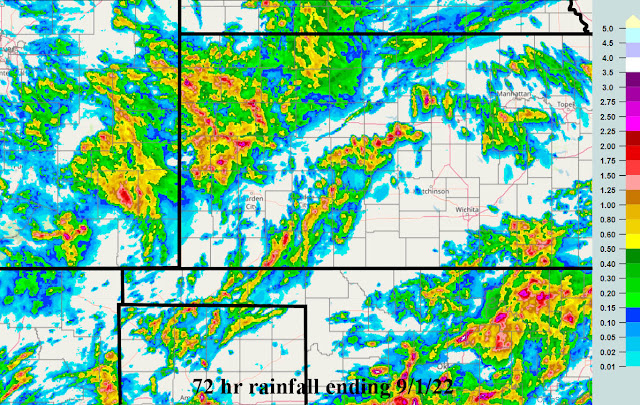
In the previous posting I did on the 19th of August, a carry over period of opportunity that I started discussing back in June mentioned the last of August.  That opportunity definately benefited some across the region.  Here is the rainfall that fell this past 72 hours ending this morning 9/1....


There were 2 events covering this precipitation.

Prior to that from last week into the weekend...here is the 72 hour map ending 8/29


Back to the post on the 19th, there was quite robust outlook for rainfall across Oklahoma and Texas.  This also verified (I'm sure many heard about the flooding in the Dallas area) but the spatial area impacted was perhaps a little less and it was a little farther south.  

We are now getting to the time of year that the old pattern that developed last fall is nearing a completion while the next pattern that will be developing this next  month.  It's going to be really tough giving you any indication of what to expect going into October.  All the longrange forecast models I've looked at are indicating a warm and dry September and likely a warm and dry October.  There is simply NO skill in forecasting for October at this point since the new pattern will be emerging then and it's impossible to predict what that will be. I do see a few opportunities for rainfall....fist tomorrow into early Saturday and then perhaps towards the following weekend, September 16-18.  Skill on those predictions is decreasing rapidly.  In the meantime, here is the outlook through next Thursday the 8th.


I'll attempt to update late next week.