Monday, July 21, 2014

July 21, 2014 Update - Wet and Green - Except for a Few

The past week saw quite a change in weather with record temperatures observed across much of the plains. Normally we talk about record highs, but this time it was for record "cold" temperatures, as was expected and noted in the previous post. See the previous post here.   At the Dodge City airport we had the coldest three day stretch of high temperatures for July since records started back in 1874!  The daily average temperature tied for the coldest stretch too!


Along with the "cold" temperatures there was widespread rain and drizzle but unfortunately (for some) the amounts were rather disappointing.  The heaviest rains fell from Jetmore to southwest Barber county and also across the area from Elkhart to northwest of Liberal.  In these areas amounts of 1 to 3 inches were common with several 4 inch amounts reported.  But, there were also areas that received only a small amount of rainfall.


In the post last week I had mentioned the heavy rains that had fallen across the foothills of Colorado and adjacent plains of southeast Colorado that produced flash flooding.  There was a large volume of water flowing down the Arkansas River, both above and below John Martin Reservoir.  Additional heavy rains fell during the remainder of the week and it appeared that water might actually make it to at least Garden City. Hmmm.  It is SO apparent that irrigation has a dramatic impact on water in the river.  All or almost all the heavy flow of water was diverted into the irrigation ditch system (and into privately owned Lake McKinney in Kearny County).  Water flowing down the Ark had been diverted into four irrigation canals; 1) Frontier Ditch near Coolidge; 2) Amazon Great Eastern Ditch near Lakin; 3) Southside Ditch near Lakin; and 4) Farmers Ditch near Deerfield.  Look at the water flowing through the Amazaon Great Eastern Ditch! WOW!
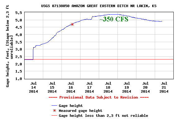
That is 350 Cubic Feet per Second of water going through just one irrigation ditch! That is a heck of a lot of water!  So, not only has the water NOT reached Garden City, it hasn't even reached Deerfield!  To me that is disappointing and amazing!

Off the soapbox...

The additional rains last week have helped a little in terms of the drought.  Much of Kansas and the central/southern plains still are in an extreme or exceptional drought due to the length of the dry spell before the rains.


At Dodge City we're doing pretty good since October 1, 2013.


But as mentioned in the previous post, there is still a huge deficit since the beginning of Water Year 2010.


Outlook for this week and into August

In a previous post I had mentioned the North American Monsoon (it's not a "real" monsoon).  The pattern is still set up just fine with copious moisture moving north out of the Mexico into New Mexico and Colorado.  The only problem?  Temperatures in the plume are unusually warm which is now preventing widespread thunderstorms!.  The satellite image below shows the flow of moisture.


Typically in this pattern there would be numerous afternoon thunderstorms across the Rockies (as there was last week).   Still, there should be convection, just not quite as widespread as normal and some of this will drift into Kansas.

Our attention is now drawn to the upper low over California (the L) and the jet stream across the Pacific Northwest.  In addition (not on this map) there were several typhoons across the western Pacific.  The typhoons will force the jet stream to buckle and will take the California low north, east and then southeast into the midwest towards the end of the week.  The result will be another cold front into the plains, but not as cold as last week.  The upshot will be cooler (not colder) temperatures and an increase in opportunities for thunderstorms by next weekend (July 26-27).

So, the weather pattern is NOT expected to become stagnant with day-after-day of 100+ degree weather. Rather, there should still be periodic fronts (some stronger than others) for the balance of July and into August.   With these fronts there should be a continued chance for thunderstorms on occasion although nothing widespread is on the immediate horizon.  Hopefully those unlucky ones that have not benefited from this active summer will finally get a rain or two.

Looking deeper into August there are some signals/signs that the month may not be too hot - or dry!  One of the long range computer models actually is forecasting MUCH below normal temperatures across not only Kansas but also across the Corn Belt.  I know that much of the corn was planted late this past spring and we need to start thinking about if the corn in that area will be able to mature before the first freeze.  Something to think about and watch.

August can be a real tricky month to forecast for as the jet stream is typically at it's weakest across the northern hemisphere.  Any notable and repeating pattern usually dies out completely during August so we have nothing to go on other than looking for subtle changes in the flow aloft and at the surface.  If I had to make a guess I would go for near to slightly below normal temperatures and near normal rainfall.  Again there will be those that receive less than normal rain and those that get quite a bit.  There should still be hot stretches but not L O N G stretches.

BTW, we CANNOT make an assumption about early freezes and winter weather based on what happened during the summer.  The pattern will re-establish itself by late September or early October as the flow aloft increases due to the changing of the seasons.  At that time we can get an idea on what is possibly in store.  I will say, however, that looking strictly at records that the following winters after a record cold spell in July that most have tended to be dry and cold.  Caution:  I'm not saying that will be the case this winter.  Give me a month or more to start looking at that.

Lately temperatures across the Arctic have been below normal and the phase of the Arctic Oscillation (AO) has tended to neutral and is expected to go to slightly above.  But, if conditions continue as such across the Arctic and the phase of the AO goes strongly negative then I would expect a VERY sharp cool down into the Midwest and possibly central plains.  I'll keep an eye on that.


I hope to update again around July 30.

Monday, July 14, 2014

Update - July 14, 2014 - Rains and a BIG cool down

As discussed in the June 26th update, the atmosphere finally gave up the fight to summer.  The flow aloft had significantly decreased across North America and the North American Monsoon has commenced.  There has already been heavy rains across parts of the Rockies of New Mexico and Colorado.  In fact, a very heavy rainfall event occurred across the eastern plains of Colorado over the weekend resulting in flash flooding in the Rocky Ford, La Junta and Lamar areas and adjacent areas of southeast Colorado.  The Arkansas River responded with high flow headed towards the Kansas/Colorado border.  There might even be enough flow to eventually make it to Garden City and perhaps even farther east!  The graph that follows shows the increasing flow (cubic feet per second) along the Arkansas River near Granada as of Monday afternoon (July 14).


Now if you read carefully above you might have caught that I said the flow aloft HAD significantly decreased.  But as of this writing the jet stream has strengthened and dipped WAY south into the upper midwest.  It is definitely an anomalously strong dip south and anomalously strong jet stream for mid July.  This dip is sending a significantly strong cold front south into Kansas and eventually into Texas.  Unfortunately it was too strong to help bring widespread thunderstorms to the high plains although scattered storms did develop as they moved into Oklahoma.

The following map shows the position of the jet stream and upper flow and other features...


A notable feature on this image (from Monday afternoon) was the low over northern Idaho.  This system should drop southeast as it rounds the corner from the anomalously strong system over the upper midwest.
The result should be rather widespread rain and thunderstorms from late Tuesday into early Thursday.  In addition, temperatures across the corn belt and much of Kansas will be much colder than average for the remainder of the week (14th - 19th).  There may be some records set, especially given the fact that highs across the eastern 2/3 of Kansas may struggle to get out of the 60s on Wednesday!  As for rainfall, the Weather Prediction Center is fairly confident with the rainfall.  The following map depicts expected precipitation through Sunday night July 20th.  Not everyone will get this much precipitation, while others will get even more than that!  This is just an expected average.  This is great news from parts of Texas and Oklahoma where it has been getting increasingly dry again...

The convective season (considered to be the warm season months) has brought a lot of rain to much of Kansas but sadly there are still areas that have missed out (by chance).  The following map shows an estimate of rainfall since April 14, 2014...


One area south of Mulliville, KS in Kiowa county has had a little over 20 inches during this period!  WOW! A large part of the region has had much above normal amounts during this 90 day period, while other locations across the far southeast parts of Colorado and southwest Kansas have received much, much less.

Even with the much above normal rainfall for late May and June, there is still a huge deficit of precipitation over a longer period.  At Dodge City at the airport, precipitation was above normal for the period October 1, 2013 through July 13, 2014 (considered part of the 2014 Water Year).


But going back to October 1, 2010 the deficit is pretty clear...


It's much the same across the entire high plains area.  So, it is not surprising that much of the region is still technically in a drought.


Outlook look for the remainder of the summer.

The NA Monsoon mentioned above should continue into early August and will be robust at times.  I'm confident that southern and central Rockies will have above to much above normal rainfall into August.  The adjacent plains should also see above normal rainfall.  There is still a question on how far east this will get into Kansas.  Even though it will be getting hot again across Kansas (and with a smattering of 100's) next week, there will still be additional cold fronts enhancing the opportunity for convective events into August. With moderate confidence, rainfall for all of July should be normal to above (again there will be unlucky ones with below normal liquid).  The average temperature for July should end up below normal across much of the high plains.  Will we reach 100 in Dodge City this year?  Probably, but not many times.  I'm going for 3 so we'll see.

Later in August I'm not seeing a huge change.  There will still be a few fronts but I'm not seeing the blast furnace type of weather that we sometimes get.  Overall for August, I'm looking for near normal temperatures and near normal rainfall, if not above.  More on August at a later time...

Finally, what about El Nino?


The Southern Oscillation Index (SOI) is a measure to where we can see the progress of a developing El Nino or La Nina.  To have an El Nino, the numbers should be significantly negative for an extended stretch (like 3 months).  That green line above should be negative.

If you read back through earlier posts I had mentioned several times that there was a question about the strength of El Nino, or if it might even develop!  Much of the media and national weather enthusiasts have been predicting a "super" El Nino.  I just don't see that happening and I'm really starting to wonder if one will develop at all!  Regardless, other forcing mechanisms across the globe are calling the shots for our current weather regime.  What I'm saying is we don't need an El Nino (ENSO only partly influences our weather across Kansas anyway) to get beneficial weather.

I'll try another update in about a week.  I might even give a hint to some early thinking for the late fall and winter too.  It's still early but I'm starting to have a hunch.

Saturday, July 12, 2014

Update is coming soon...

To those that I visited with at the 3i show in Dodge City this past three days (Thursday - Saturday) and to those that I did not get to visit with...I'll be updating this blog on Monday.  I've had a very hectic schedule recently that has prevented a timely post.  While I'm updating this currently, a large area of rain and thunderstorms had developed late this Saturday afternoon and evening across southeast Colorado (July 12).  This is in advance of MAJOR changes coming this week in terms of colder (not cooler) conditions.

More Monday...

Thursday, June 26, 2014

Update - June 26, 2014 - We're still in an active pattern but summer is setting in!

See the previous post by clicking here

Additional convective events have taken place since the last posting.  This morning (Thursday June 26) another MCS (Mesoscale Convective System) was sliding southeast into south central Kansas.  The 14 day precipitation map does not include much of this precipitation.  Over the past two weeks there has been excessive amounts of rainfall and unfortunately some damaging hail and high wind.  The hail and wind is certainly not unusual even for late June.  Some areas have measured in excess of 6 inches during the period. All areas have received rainfall but there are still pockets that have missed out on heavier rain and have received  less than a quarter of an inch.


For the month of June much of the area has received much above normal rainfall and in some cases near record values.  The map below shows areas in pink that have measured between 10 and 15 inches for June! But at the same time, there are a few localized spots near Elkhart, Johnson, Coolidge and near Hugoton that have received  less than 1 1/2 inches of rain.


Locally in the Dodge City area rainfall has varied in amounts too.  At the Dodge City airport we have had 6.81 inches (keeping in mind that in town MUCH heavier rain has fallen - even double) and this is the 8th wettest June, so far.  For the Water Year (that started October 1, 2013), the accumulated precipitation has now gone above normal.


However, there is still quite a deficit going back to the beginning of Water Year 2011 that started October 1, 2010.  Many areas across the high plains are similar if not worse.


Because of the deficits, much of the area is still in a drought.


So, this has certainly been a nice period of improvement but much, much more rainfall is needed to break the long term drought that took years to develop.  During the short term, that is through early July, there should still be opportunities for systems of storms rolling off the high terrain to the west.

Sometimes when it gets green and wet there are some feedback mechanisms into the atmosphere that promote additional opportunities for convective events during the warm season.  West Texas and eastern New Mexico did receive abundant rainfall during the past 30 days and this will have a positive influence on Kansas weather, at least for the next several weeks. However, there does now appear to be changes taking place in the atmosphere that point to a summer pattern developing.  Does this mean it's suddenly going to get hot and dry?  Not likely.

I still am holding hope that with some feedback into the atmosphere and with a residual but diminishing overall favorable weather pattern that there should still be periodic opportunities for convection well into July.  I'm hoping that a Rockies Monsoon (that typically develops during the first part of July and lasts into August) will be developing soon.  With the overall pattern we've had this should help areas of eastern Colorado and far western Kansas.  How far this activity gets is a big unknown.  More on this later.

There should still be periodic cold fronts (weaker) that should bring a few days of thunderstorms across the high plains.  In the earlier post this week I had mentioned a "cold" outbreak for the July 4th period.  It still looks to be on track but mainly impacting the upper midwest/corn belt.  We should still get a taste of that well into western Kansas.  Thus, I would not be surprised to see a couple of days of storms from July 2nd through July 5th with below normal temperatures.

So, for July I would expect near normal rainfall at most locations.  Yes there will be spots that receive much above normal  rainfall due to stronger storms at their location and unfortunately a few spots will receive less than normal rainfall.  Temperatures should end up near normal to slightly above but I don't see days and days of 100's and wind.

One final thought...there continues to be much talk about El Nino.  We are NOT in an El Nino just yet and there continues to be some uncertainty about that evolution (even if it will develop, let along becoming a strong one).  I'll talk more about this later but for now I offer the following graph.  The numbers of SOI (Southern Oscillation Index) needs to be significantly negative for several months.  It just hasn't happened yet.


I'll try and update this blog again around July 11.

Saturday, June 21, 2014

Brief update - June 21, 2014

Due to time constraints and travel to conferences I have not had time to update this blog.  This will be brief.

NOTE:   It would also be helpful to read the previous posts on this blog if you have not done so before now.

For official long range forecasts, go to The Climate Prediction Center.


During the past 3 weeks the overall weather pattern has certainly been favorable to produce precipitation, finally!  As expected the pattern has evolved into one that provides opportunities for precipitation.  In addition, the pattern is NOT favorable for very hot days.  Yes, there have been a few 100 degree days but for the most part there has not been extreme heat.  Dodge City has failed to reach 100 this year and it appears that we will go through June without an occurrence.


Some areas of central and southwest Kansas have had in excess of 10 inches during the period!  There are large pasture ponds in parts of Clark, Kiowa, Clark, Ellis and Trego counties (as well as other central and eastern KS counties) that filled after having been dry or nearly dry for several years!

The U.S. Drought monitor shows the area has improved as far as drought is concerned (long term conditions) but there is a lot of improvement needed.


The outlook through the remainder of June is for a continued opportunity for rainfall, and in some cases excessive rains.  Temperatures will likely remain normal to below.  I doubt there will  be any 100 degree days although a few spots could top the century mark.  Looking into July, I expect there will be additional episodes of precipitation and cooler temperatures.  Overall, July may end up near to above normal on rainfall and temperatures will likely end up around normal.  This outlook will be reassessed next week (week of June 23).  One period I'm watching with interest is around July 4th, or at least that first week of July.  There are some early indications that it may turn much colder with ample precipitation then.  If that pans out, there may not be ANY 100 degree days at Dodge City for July!  I'll take a deeper look next week.


The Weather Prediction Center of the National Weather Service is calling for quite a bit of rain during the next 7 days, which I concur.  It looks like late Sunday into Monday (22nd and 23rd) there may very well be widespread 1 inch rains with isolated 3 or 4 inch amounts possible. This is contingent on the development and evolution of an  MCS (Mesoscale Convective System) but it is looking more and more likely.

Rainfall expected from June 21, 2014 through early June 28, 2014

Friday, May 30, 2014

Late May update (May 30, 2014)

NOTE:   It would also be helpful to read the previous posts on this blog if you have not done so before now.

For official long range forecasts, go to The Climate Prediction Center.

(Click on images for a larger version)

Since the last posting on May 9, 2014, there have finally been small signs of what I've been expecting. Although not everyone received precipitation, or at least a substantial amount, there were definitely areas that received copious amounts of rainfall.


Unfortunately, there are still many locations that have not received much rain.  Therefore, the drought continues and in fact has intensified as we get deeper into the warm season.  But, areas of west Texas and eastern New Mexico did receive substantial rains and that, hopefully, will help it to green up which will have an impact of the high plains of Kansas later this summer.


Picking just one site, in the case Dodge City, shows how the deficit of precipitation keeps growing.  Keep in mind that parts of Ford County and Dodge City received very heavy rainfall on Mothers Day (May 11).


Without that rainfall the growing deficit at Dodge would be so much greater!  The graph above shows the accumulated precipitation for Water Year 2014, or from October 1, 2013 through the current date.

The next graph illustrates just how bad it is getting (and it's a lot worse at other locations).  This graph shows the accumulated precipitation since October 1, 2010 through the current date (or WY 10 through WY14).


So is it going to get better?  If you surf the 'net' there are varying opinions.  Some say the drought will expand and intensify throughout the summer and into the fall.  Personally, I've been expecting a gradual change to a wetter regime and so far that is the trend (although it would be hard pressed to see at a lot of the very dry locations).

However, one of the biggest disappointments of this trend is the lack of widespread heavy rainfall that SHOULD have occurred this past 10 days of May.  An upper low formed over northern California on May 19th and it has taken 10 full days to reach northern Louisiana.  The track and position should have brought a copious amount of rainfall to a very large part of the central and southern Plains.  Indeed there were many locations that did receive a bunch of rain, and some that had excessive rainfall.  But the rest of us? Puzzling.

This pattern of slow moving systems will likely repeat several times until late summer.  At the same time there should be an above normal amount of frontal passages into the U.S. and the thought is that many of these will make it as far as the central plains.  Given that scenario, I'm optimistic  that above normal rainfall will result across much of the high plains as moisture is transported westward into the higher terrain to the west.  The "killer" to this may be the upper level ridge that should set up somewhere across the Texas.  Will it be too strong and cap the atmosphere?  That is a possibility which would limit the chances for periodic convective systems, and therefore bring rainfall totals back to normal or even a little below normal.

One of the long range computer models (CFSv2) has been very persistent and consistent in forecasting at least normal if not way above normal rainfall into July.  This model generates an outlook based on current conditions and is run several times after changing initial conditions slightly.

The graphic below shows the wettest run of the CFSv2 based on data from upper air soundings on May 29. As you can see, it is VERY wet!    The second map shows the average of all the runs based on the same data.


Again, this computer model has been very, very consistent in this type of output.

Finally, you may have heard about an El Nino developing and even developing into a super Nino.  Hold on, there is more to the story.  So far it has been a major struggle for the event to even start.   I don't like the trend.


The green trend on the graph above should be dropping to well below zero.  So far, it's not!  There are very warm waters just north of Australia and this may prevent a coupling of the oceanic warm waters in the western Pacific basin.  What that means that IF an El Nino develops this fall and winter, it may not be that strong.  That could have impacts on the western U.S. and southern states, which in turn would impact weather in Kansas.   We need to root for a decent El Nino as all major recorded droughts in the plains states have been broken by such an event.  Computer models still indicate that one will develop later in the year and into next - the stronger the better I believe.


I'll update again after June 15th.

Friday, May 9, 2014

Latest Update on the Sring & Summer Outlook (May 9, 2014)

Before going further, make sure you review the original post made on April 15, 2014...located at Spring & Summer Outlook.

It's been a very disappointing weather regime so far this spring.  Under ideal and even "normal" spring conditions, these weather systems that have brought "weather" to parts of Texas, Oklahoma, Missouri and points east (and even far eastern KS) would have brought many rounds of spring storms to all of Kansas.  As it stands, it appears the flow aloft has just been too strong and too far north and with bad timing.  Boundary layer moisture has not had a chance to move far enough west to be lifted by these systems.  Early in the Spring the moisture was even too limited across Texas and the deep south due to persistent cold fronts during the winter.

Now that early May has arrived, at least the gulf moisture has been more robust and farther west and north.  What this means is that with time, moisture will be utilized by the weather systems moving in from the west so that precipitation opportunities will be increasing.   Granted it is likely too late for much of the winter wheat, especially in the hardest hit areas of the drought.  All the very long range forecast models (U.S. and abroad) have been persistently indicating above normal precipitation for May.  It is bothersome that  scenario has not been realized yet.  Each passing day that nothing materializes leads to less and less confidence.  But at least the cycle is there...it's just a matter of time!

Not only has the dryness increased across much of the area bringing the demise to much of the wheat crop, but now we'll have to worry about another freeze!  As has been expected since late winter, this next cold outbreak is right on time.  This next week (May 12-17) will see low temperatures well into the 30s and with any clearing and decreasing winds, there is a chance the mercury will fall into the upper 20s across at least far northwest Kansas.

Update on the drought.  The latest is the drought assessment for plains updated on April 29, 2014.

...and for Kansas...


Speaking of the optimistic long range models.  The  Climate Forecast System Version 2 (CFSv2) from NOAA has the following forecast (just one model run) for the period of May into early June.  Needless to say...WET!


If this verified, almost the entire corn belt would be very wet!  And, wet across most of Kansas!  Again, these models have been very persistent with these wet outlooks but it just hasn't started yet.  I'm still staying optimistic that things will turn around.

Finally, as I pointed out in the mid April post, all major droughts have been "busted" by developing El Nino conditions.  An El Nino has been expected to develop, but so far it has been a VERY slow process with some thought that it might not happen!  The following is an updated plot from April of the SOI (Southern Oscillation Index).  We want to see negative values!  It is slowly trending that way, at least (look at the 90 day or green line).


The outlook is for the El Nino to continue to develop, and with high confidence of that happening.  The big question is just how strong it might get and for how long.  I wouldn't be too suprised to see just a weak/moderate Nino and wouldn't persist too long given the state of the atmosphere and climate.  But at least it would increase the opportunity for above normal precipitation later in the summer and into the winter and next spring/summer.


I hope to update this again before the end of May.