The weather has certainly been interesting this past week! From severe thunderstorms to a major spring snowfall. In the previous post I gave some periods that I believe to have pin-pointed. If you didn't read that post, click
here.
In the previous posting, I provided a link to a very short and quick survey that will help me determine the future of this blog and posts. If you have not filled out that survey (again it's very brief), please help me out and do so. That survey link is:
here
To date I have posted 299 times, this one is my 300th! The first one I did was on April 15, 2014! Wow I can't believe it was that long ago! For those of you not too familiar with this blog, I have done it on my own time unrelated with my employment with the National Weather Service. If you want to read that very first blog post, click
here. I need to determine if I will continue.
In the previous posting, I discussed the active weather expected for the period of March 10-17, but especially March 15. Well it certainly has been active with the highlight being the 13th/14th. It looks like the storm coming in tonight and moving out tomorrow (16th-17th) will be the end of that active period. But, there is more to come!
BTW, here is the estimated precipitation that has fallen this past 7 days, ending this morning March 16.
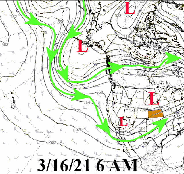
Here was the upper air chart this morning...
The Storm (the red L across Arizona) for tonight and tomorrow will be very compact making details in the forecast (type of precipitation and specific amounts) extremely challenging for forecasters. The exact track and mesoscale processes will determine the final outcome. Here is the guestimate from the Weather Prediction Center for the next 7 days (with the majority of this falling with this first system)...
So, if you didn't go back to the post on the 5th, here is the outline I left you with....
These following periods are not the ONLY possible weather....they just have my attention.
1) March 10-17, but especially around March 15. This should be the next active period but probably only 1 storm will impact the high plains and that would be around the 15th. Before then it could be the eastern plains. I wouldn't be surprised if there was a blizzard, especially for higher elevations of the high plains.
Instead of 1 storm for the high plains - make that 2 although much of the high plains north of Kansas will miss out on this one.
2) March 25-31 is a period of potentially much below normal temperatures. That could be problematic as with this recent rain and the mild temperatures coming up, there may be some early breaking of dormancy of some vegetation. Also, the b word comes to mind. The last 10 days of March are actually the most active for blizzards, based on history.
I think there will be a few more opportunities for storms as March is closing out. Any system that would bring much below normal temperatures is not showing up at this time. But, I still think there is that chance.
3) April 17-20 could be interesting. If the warm sector is far enough north/west then perhaps a severe weather outbreak? Hopefully no blizzard but I wouldn't be surprised for areas of the high plains.
This still looks to be on track.
4) April 25-May 2 could potentially see much below normal temperatures. If there is going to be a late frost or freeze, that would be the time period.
No change in the thought process for this period.
I will wait a bit more before venturing out on a summer outlook.
Again if you didn't have a chance to fill out that brief survey, I would appreciate it greatly if you could help me out.


No comments:
Post a Comment