Thursday, August 10, 2023

September is the transition month - what can we expect going into fall?

For many in the Great Plains, July was near normal to above normal, and in some cases, exceedingly wet.  Yet, there was quite a large area (comparatively speaking) that did not benefit from the continued active weather pattern.  Here is a look at the rainfall percent of normal for July....


This was a shift in the pattern from what had been a wet northeast Colorado, northwest Kansas and western Nebraska.  However, so far in August this wet area has shifted back north.  Now the question is will that continue as we transition into fall? 

One good thing about the wetness across what had been the hardest hit area of the drought is that temperatures were highly mitigated due to the wet ground and lush vegetation, 

The upper air map is illustrating an unusual southern shift in a relatively strong jet stream (compared to normal for August).  Here is the map from this Thursday morning...


The shift can be tied to many things going on across the northern Hemisphere (namely areas of forcing and those teleconnections).  This might be a clue going into the fall months and into winter/spring in what we can expect as the new weather pattern (2023/2024) begins to organize.   This is and will be discussed at length in outlook reports that are sent to clients of Hutton Weather Futures.  Consider joining those already subscribed that are informed to make business decisions from accurate long-range forecasts!  Visit my website Hutton Weather Futures for additional information on how to subscribe.

Thursday, June 29, 2023

Wet July?

This crazy weather that went from a significant drought to significant wetness (for many) looks to continue off and on this summer.  The upper-level flow this past 60 days has been unusual at times.  For a while back in May winds aloft were anomalously week for the time of year and actually contributed to westward moving convection and can be attributed to some of the monstrous rainfall totals this past 45 days.  There are rainfall observations of 15 to 20 inches since May 1 and I can find quite a few of those reports in the Texas Panhandle, east central Colorado, western Kansas, and southwest Nebraska.  Of course, as is typical with convection, adjacent locations missed out on some of those bigger rains.  There are locations that have had 5 to 6 times normal rainfall!  Look at the map of percent of normal rainfall in the 60-day period ending 06/25!!


Of course, we should not expect these types of anomalies for the remainder of the summer.  It's not a zero percent chance of that happening, but the atmosphere will likely not allow it.  The upper air map from this morning shows a continued active pattern despite being late June. 


The winds aloft are certainly weaker than they would be earlier in the year, but still strong enough to support occasional complexes of storms, similar to what moved across Nebraska and northern Kansas overnight (6/28).  As long as the upper high across southwest Canada continues to dominate at that location, and the upper air high (currently over Arkansas and Louisiana) doesn't expand into the central part of the country and park there, then I believe there will be continued opportunities for more rain in July.  I don't see much chance of a repeat of July 2022 when the spigot was shut off.

In the reports I send out through a subscription to Hutton Weather Futures, I have detailed and highlighted those periods/days of increased odds of rainfall for July and August.  Conversely, decreased odds of any rainfall have been noted.  Ideas of when the first fall freeze are shaping up and I've come up with odds on that.  Won't you consider joining the growing number of folks that have been reaping the benefits of accurate long-range forecasting!   Visit my website for additional details on how to sign up.

Wednesday, May 10, 2023

May is all over the place!

This past month has seen varying amounts of rainfall (and snow in some areas) which is certainly typical for the Great Plains.  However, the same areas that have been hardest hit from the drought seem to be missing out on many of the opportunities, but yet there was one widespread rainfall event the last week of April that blessed a large part of southwest Kansas.  Look at precipitation this past month....


The colder than normal conditions and precipitation had been expected as I laid out months in advance. Based on the pattern that set up in the fall and timing the harmonics of the wavelength of the pattern, I have identified the most likely periods of opportunity for rainfall going into June.  Of course, it doesn't mean that it will rain everywhere on a given day or period, it is just the time of increased opportunity that the atmosphere may respond with more rainfall.  A sample graph for June is below.  For folks that have subscribed to my outlook reports I will advance this into July and August as well and include periods of when I expect the most heat to be.


Consider joining this premium service that could help you in planning of your operation in the crop and livestock world.  Try it out for a month for $100 and see what you think!


Go to:  https://huttonweatherfutures.com/ to learn more about that opportunity for a premium service.

Thursday, April 6, 2023

Same pattern, same result

The active pattern continues but has produced about identical conditions across the Plains and into the midwest and Mississippi Valley.  The wind and dirt have been brutal, but expected.  The blizzards and heavy snow across the northern parts of the western Corn Belt have been significant.  The severe weather including tornadoes across the midwest and Mississippi Valley have been expected based on my reports I have been providing.  Here is the precipitation totals that have occurred this past 30 days ending today April 6....


Prospects for changes for April are not great.  There are subtle hints of better things to come but it could be a while yet.   In my reports to my customers of Hutton Weather Futures I have addressed these opportunities.  

Consider joining this premium service that could help you in planning of your operation in the crop and livestock world.  Try it out for a month for $100 and see what you think!

Go to:  https://huttonweatherfutures.com/ to learn more about that opportunity for a premium service.

Friday, March 17, 2023

More wind - little precipitation - better days ahead

This past weather system that rolled through yesterday, March 16, packed a punch in terms of crashing temperatures and high wind.  At least a little precipitation was generated. 

Here is a map showing what fell during the 3 day period of March 14-16...


In the report I sent to the subscribers to my longrange outlooks, the next period that "could" bring some precipitation is coming up next week.  It likely won't be just one system, but a series of weaker storm systems.  After that there should be a couple more opportunities going into April.   In the report I sent out to those subscribers and in subsequent reports I'll be sending, more dates of opportunity have been identified.  Please consider joining this premium service that could help you in planning of your operation in the crop and livestock world. 

Go to:  https://huttonweatherfutures.com/ to learn more about that opportunity for a premium service.

Thursday, February 23, 2023

Update 02/23/23

As a reminder I will only be updating this blog site on occasion as I move forward with my consulting company, Hutton Weather Futures LLC.  I will provide more detail in outlooks emailed to subscribers and the reports will of course be much more frequent as a subscription service.  That web address is https://huttonweatherfutures.com/  

As I have mentioned in the reports I have been emailing to my customers, weather systems in this current pattern are on schedule.  The next system that I have targeted is for late this weekend.  It will likely be the first severe weather "outbreak" for the central part of the country.  Rainfall on the west end will be limited once again but may be farther west this time.

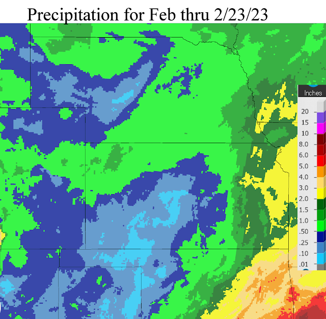
So far for February, the results from the active pattern have been nearly the same (eastern areas benefiting greatly).  Here is a map of precipitation that has fallen this month (February)....


Other systems are due periodically in March with one in particular expected around the spring equinox. 

Hopefully you will consider subscribing to my consulting update reports as I'm certain I can provide useful information (inputs) into making your crop and livestock production profitable.  

Wednesday, February 1, 2023

Weather Systems are on schedule?

 First - if you haven't been visiting this blog site lately, please review the one I did on January 20 (click here) to read up on how this blog will be handled going forward.  With my consulting company, Hutton Weather Futures LLC, I will provide more detail in outlooks emailed to subscribers and the reports will of course be much more frequent as a subscription service.  That web address is https://huttonweatherfutures.com/.  I will only occasionally update this blog site "swkswx.blogspot.com". 

As I have mentioned in the reports I have been emailing to my customers, weather systems in this current pattern are on schedule.  The next system that I have targeted for February 7-8 has been showing up in some of the long-range computer forecast models but with inconsistent timing and inconsistent features.  Confidence is fairly high that there will be impacts across parts of the Great Plains.  Details at this point are uncertain.

Looking at the current upper air map, any potential storm for next week is not really showing up on this map at least as of Wednesday evening (1st)....


The storm moving across northern Mexico has been weakening but still very capable of producing a widespread precipitation event from southwest Texas and eventually into the lower Mississippi Valley.  It is way too far south to impact the central plains.   The strong system across the eastern Pacific (the big red L) will be moving northeast into Canada and will only promote warming for the central plains but with no indication of any moisture.

Any potential storm next week hopefully will benefit the area that has been consistently getting missed as you can see in the precipitation maps for January (the first is the amount and 2nd is the precent of normal).


For January that is a hefty amount of precipitation for Nebraska and northwest Kansas!

Again, I have started the subscription service at https://huttonweatherfutures.com.  I hope you will consider subscribing and join the others receiving these frequent updates of the expected weather as we get into the growing season.